
Downtown Winnipeg rewards walkers with a compact core where riverfront paths, cultural landmarks and heritage streetscapes sit within an easy stroll of one another. This self-guided route highlights ten essential stops that can comfortably fill a day on foot, with plenty of time for coffee breaks, gallery browsing and lingering on scenic benches. Whether you are visiting for the first time or rediscovering the city, these stops trace a loop that connects the rivers, the historic Exchange District and the modern heart of the city.
How to Use This Downtown Winnipeg Walking Route
This walking route is designed as a flexible loop beginning and ending at The Forks, one of Winnipeg’s most accessible and visitor-friendly hubs. The sequence moves from the riverfront through the historic Exchange District and back into the modern downtown core before returning to the water. Walking time between stops is generally 5 to 15 minutes, though you may want to allow longer in winter conditions or if you plan to explore galleries, museums and shops in detail.
Distances are deliberately modest so the route works in all seasons, including Winnipeg’s very cold winters and warm, often humid summers. Surfaces range from paved riverwalks and sidewalks to occasional cobblestone or brick sections in heritage areas. Comfortable footwear, layered clothing and awareness of changing weather are important, especially along the riverfront where wind and ice can alter conditions quickly.
You can follow the full loop in a single day or break the route into two or three shorter outings. Transit connections, ride-share pick-up points and the covered Winnipeg Walkway network in the core make it easy to shorten the walk or adjust it for accessibility needs.
Stop 1: The Forks National Historic Site
The Forks, at the confluence of the Red and Assiniboine rivers, is an ideal starting point for a downtown walk. This riverside gathering place has served as a meeting ground for Indigenous communities, traders and newcomers for thousands of years and today blends green space, public art, markets and riverfront paths in one compact site.
The Forks Market and Public Spaces
The Forks Market occupies former railway stables that have been converted into a multi-level hall filled with local food vendors, small shops and artisan stalls. Inside, you will find everything from coffee and craft beer to regional specialties and Canadian-made gifts, which makes it a good spot to fuel up before you start walking or to plan your lunch stop later in the day.
Immediately outside the market, plazas and patios open toward the river, framed by public art, seasonal programming and plenty of benches. In summer, buskers and outdoor events add energy. In winter, the site often supports skating trails, fire pits and warming huts, drawing both locals and visitors even in the coldest months.
Oodena Celebration Circle and River Lookouts
Near the heart of The Forks, Oodena Celebration Circle forms a shallow circular amphitheatre that recognizes the site’s deep Indigenous history. Sculptural elements, a sundial and interpretive signage invite quiet reflection and provide a transition between the busy market area and the more contemplative riverfront.
From the surrounding paths and viewing spots, you gain an immediate sense of Winnipeg’s geography, with the downtown skyline to the west, St. Boniface across the Red River and bridges and rail lines converging nearby. This vantage point helps orient you before you start walking northwest along the waterfront toward the Exchange District.
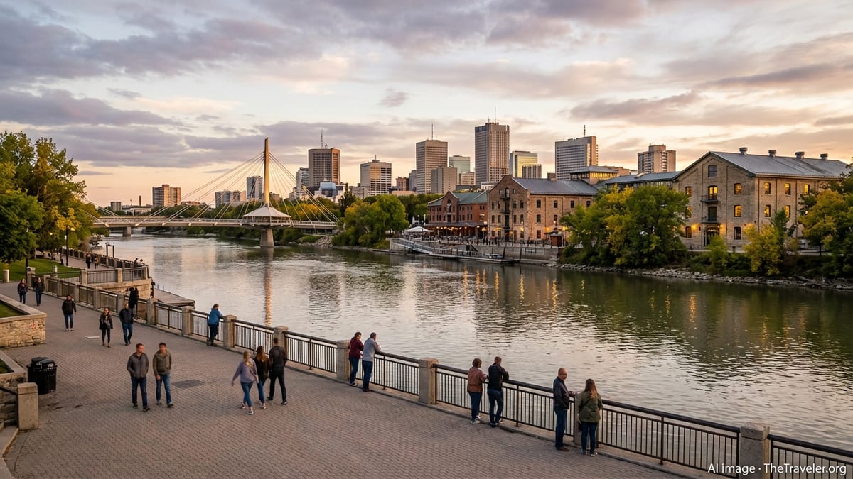
Stop 2: Stephen Juba Park and the Red River Path
Leaving The Forks, follow the riverfront north toward Stephen Juba Park. This linear green space runs along the western bank of the Red River and forms a quiet, leafy corridor between the downtown core and the historic warehouse streets to the west. It is a gentle walk that trades traffic noise for birdsong, public art and filtered skyline views.
The park was created in the 1980s when the city and province set aside waterfront land for public use, and it has since become a favourite for joggers, cyclists and strollers. Its broad paths and open lawns offer a very different perspective on downtown than the commercial streets just a few blocks away.
Waterfront Trails and Public Art
The multi-use pathways through Stephen Juba Park are generally flat and paved, with occasional connections up to surrounding streets. Along the way, you will encounter pieces of public art by local artists, low stone walls, interpretive panels and a modest dock area used by seasonal water taxis when river conditions allow.
In summer, mature trees provide dappled shade and glimpses of boats on the river. In autumn, foliage adds rich colour, while in winter the riverside can feel particularly quiet and expansive. The park’s open sightlines and frequent benches make it a comfortable section of the walk to slow down and simply watch the river’s changing moods.
Transition to the Exchange District
Several short streets connect Stephen Juba Park with the eastern edge of the Exchange District. As you turn west from the park, the environment shifts quickly from natural riverbank to brick warehouses, narrow lanes and historic commercial buildings. This transition marks your entry into one of Canada’s most intact early 20th century commercial districts and sets up the next series of stops on the route.
Stop 3: Old Market Square and the Heart of the Exchange District
The Exchange District covers roughly twenty city blocks packed with heritage warehouses, former financial institutions and early skyscrapers. Old Market Square, near the centre of the district, offers a natural gathering point and a convenient place to orient yourself among the angled streets and intricate façades.
Once the hub of grain and wholesale commerce, the Exchange has evolved into a mixed-use neighbourhood where design studios, independent retailers, restaurants and cultural institutions occupy refitted heritage buildings. Its streets reward slow exploration, with details such as original signage, decorative brickwork and ghost signs revealing layers of history.
Old Market Square and The Cube
Old Market Square itself is a compact park framed by historic brick buildings and tree-lined paths. At its centre stands a distinctive metal performance structure often referred to as The Cube. During the warmer months, the square hosts outdoor concerts, festivals and special events, while the surrounding patios and cafes offer prime people-watching.
Even when no events are scheduled, Old Market Square functions as a living room for the district, with seating, public art and views down character-filled side streets. It is also a common starting point for themed walking tours, including history, architecture and seasonal ghost walks that delve into the area’s stories.
Warehouse Architecture and Side Streets
From the square, wander along streets such as Bannatyne, McDermot and Albert to experience the district’s trademark warehouse architecture. Many buildings date from Winnipeg’s boom period between the 1880s and early 1900s, when the city’s position on the railway network and its role in the grain trade drove rapid construction.
Look for stone and brick exteriors with large arched windows, detailed cornices and former loading docks now converted into café entrances and shopfronts. The narrow, sometimes angled streets, together with remnants of cobblestone and lane networks, create an urban fabric that feels markedly different from the more modern grid to the south.
Cafes, Galleries and Creative Spaces
The Exchange District has steadily become a cultural and creative hub, home to independent galleries, design studios, specialty shops and cafes. Many operate at street level in restored warehouse spaces, while upper floors house offices, studios and residential lofts.
This mix gives the area a lived-in feel beyond business hours, making it a pleasant place to linger into the evening. A coffee stop or gallery visit here offers a natural break between riverfront walking and the more formal cultural institutions that await at the next stop.
Stop 4: The Manitoba Museum and Cultural Corridor
Just northeast of the main warehouse cluster, the Manitoba Museum anchors a small cultural corridor that also includes a planetarium and science gallery. Although technically just beyond the densest part of the Exchange, the complex is close enough to integrate naturally into a downtown walking route and adds a strong interpretive dimension to the day.
Even if you do not plan a full museum visit, passing by the site underscores the role downtown Winnipeg plays as the province’s cultural centre, with institutions that explore natural history, human stories and Indigenous perspectives from across Manitoba.
Collections and Exhibits
The Manitoba Museum is known for exhibits that trace the province’s geological and ecological history, as well as detailed reconstructions of historical environments and communities. Galleries range from representations of northern ecosystems and prairie towns to displays focused on transportation, technology and human experience.
The adjacent planetarium and science-focused spaces provide further opportunities for indoor exploration, which can be particularly welcome in extreme weather. For walkers, this stop can be either a brief architectural and streetscape pause or a longer immersion in curated exhibits, depending on time and interest.
Planning Your Time Here
Because a thorough visit to the Manitoba Museum can easily fill several hours, consider your priorities for the day. Some visitors choose to dedicate a morning or afternoon to the museum and then complete the rest of the walking route on a separate day. Others opt for a shorter visit, focusing on a few select galleries before continuing south toward City Hall and the main downtown intersections.
From the museum area, it is a straightforward walk back toward Main Street and Winnipeg’s civic buildings, setting up the next two stops that highlight both the city’s governance and its most famous intersection.
Stop 5: City Hall and Civic Landmarks
Returning toward the core, Winnipeg’s City Hall area provides a change of scale from the low warehouse district to more open civic plazas and institutional buildings. This stretch of the walk highlights how municipal functions, public art and historic fabric co-exist within the downtown grid.
The space around City Hall also serves as a vantage point for understanding the broader shape of the city, with views toward the Exchange District, the modern commercial core and major arterial streets that fan outward to residential neighbourhoods.
City Hall and Public Spaces
Winnipeg’s City Hall complex incorporates administrative offices and public meeting spaces, fronted by plazas that are often used for announcements, civic gatherings and seasonal displays. While architectural opinions on the modern design vary, the site plays an undeniable role as a symbolic centre of local government.
As you pass through, notice how pathways, artwork and landscaping guide movement across what might otherwise be an expanse of concrete. Benches and plantings soften the space and provide short-term resting points before you continue south toward the city’s best-known crossroads at Portage and Main.
Connections to Nearby Heritage Streets
From City Hall, short walks lead back into the Exchange’s side streets, making this a useful pivot if you wish to revisit certain blocks or explore architectural details you may have missed earlier. The proximity of heritage areas to the civic complex highlights how compact downtown Winnipeg is, with key sites rarely more than a few minutes apart on foot.
When you are ready to move on, follow Main Street or nearby parallel routes south toward Portage Avenue, where the city’s financial, commercial and cultural activities intersect in a different way.
Stop 6: Portage and Main and the Underground Concourse
The intersection of Portage Avenue and Main Street has long been shorthand for Winnipeg itself, often invoked in national weather reports and economic commentary. At street level, it is a busy meeting point of traffic and towers; below ground, a concourse links the corners and provides sheltered passage during harsh weather.
While pedestrians currently have limited direct crossing options at the intersection itself, the underground concourse and surrounding sidewalks still make this an important stop on any downtown route, both for its symbolic value and its practical role as a transit and walkway hub.
The "Crossroads of Canada"
Portage and Main’s reputation as a key Canadian crossroads dates back to Winnipeg’s early days as a rail and grain hub, when the intersection served as a focal point for booming commerce. Today, the surrounding blocks house bank headquarters, office towers and retail complexes, reflecting the city’s ongoing role as a regional economic centre.
Standing back from the immediate traffic, you can take in the variety of building styles from different decades, noting how glass-fronted towers have risen alongside older stone and brick structures. This juxtaposition encapsulates much of downtown Winnipeg’s visual character.
Winnipeg Walkway and Underground Access
Beneath the streets, the Winnipeg Walkway system connects many downtown buildings through a network of tunnels and skyways, including an underground concourse at Portage and Main. The covered route provides year-round, climate-controlled access between office towers, shopping areas and transit stops, making winter walking more manageable for commuters and visitors alike.
For the purposes of this walking route, a short detour through the concourse can demonstrate how the city has adapted to its climate. Emerging again at street level, continue west along Portage Avenue toward the arts and entertainment district clustered near a major indoor arena.
Stop 7: Canada Life Centre and Sports & Entertainment District
Walking west from Portage and Main, you arrive at a pocket of downtown organized around a large multi-purpose arena and its surrounding restaurants, bars and hotels. This district illustrates how sports and entertainment venues can act as catalysts for downtown activity, particularly in the evenings and on event days.
Even when no games or concerts are scheduled, the area’s plazas, public art and wide sidewalks contribute to a sense of energy. The mix of visitors, office workers and residents creates a dynamic but generally walkable environment.
The Arena and Event Atmosphere
The downtown arena, home to professional hockey and other events, has become a key landmark on Winnipeg’s skyline. On game nights, fans converge from across the city and beyond, filling nearby restaurants and spilling into the streets before and after events.
For walkers, the arena’s exterior spaces, including forecourts and adjacent plazas, provide opportunities to observe public art, informational displays and light installations designed to animate the area. Security, crowd-control barriers and staff presence are more visible on major event nights, so consider timing your visit based on whether you prefer a quieter or more festive atmosphere.
Dining, Nightlife and Street Life
The blocks around the arena host an evolving collection of eateries, pubs and casual dining spots. Patio seating often appears in milder months, contributing to street life along key routes leading toward the venue.
This section of the walk can double as either a mid-route meal stop or a transition into evening, especially if you plan to pair your walking tour with a game or concert. From here, your route bends south and east toward cultural institutions and green space, closing the loop back to the river.
Stop 8: Broadway, the Legislative Precinct and Urban Green Space
Heading south from the arena area brings you onto or near Broadway, a broad, tree-lined avenue that runs west from Main Street toward the Manitoba Legislative Building. This corridor offers a calmer walking experience than the busier retail streets, with wide sidewalks, landscaped medians and views of stately office buildings and institutions.
Broadway’s generous proportions and mature trees give it a grand-boulevard character that contrasts with the tighter grain of the Exchange District. It also serves as a gateway to one of Winnipeg’s most important civic landmarks and the surrounding gardens.
Manitoba Legislative Building and Grounds
The Manitoba Legislative Building, with its recognizable central dome, sits at the western end of this section of Broadway, facing a formal lawn and gardens. The grounds are open to the public and include statues, memorials and manicured plantings that invite slow strolling and quiet rest on benches.
From the pathways around the building, you can appreciate views back toward the downtown skyline as well as details of the structure’s classical architecture. Seasonal flowers, shaded lawns and mature trees make this a popular lunchtime and weekend destination for residents, and a pleasant green pause for visitors walking the route.
Connections Back to the River
From the Legislative grounds, short paths and streets lead back to the Assiniboine River and its riverwalk, which in turn links east toward The Forks. Depending on water levels and seasonal closures, you can choose between riverside paths or adjacent streets to complete your loop.
This combination of formal civic space and informal riverbank trails illustrates how downtown Winnipeg’s most significant institutions remain closely tied to its waterways, offering walkers multiple routes that balance architecture and nature.
Stop 9: St. Mary’s Cathedral and Quiet Downtown Streets
As you angle back toward The Forks, a short detour brings you past St. Mary’s Cathedral, a Roman Catholic cathedral on St. Mary Avenue that adds another layer to downtown’s architectural and cultural mix. Surrounded by office blocks and residences, the church’s stone façade and tower provide a striking counterpoint to nearby modern structures.
This section of the walk moves through quieter downtown streets where the rhythm of daily city life becomes more apparent, from office workers on breaks to residents walking dogs and running errands.
Architecture and Atmosphere
St. Mary’s Cathedral combines Romanesque revival and European-influenced design elements, with arched windows, stonework and a traditional interior layout. Even viewed only from the outside, the building offers a sense of continuity with the city’s late 19th and early 20th century growth.
Side streets in this area feature a mix of mid-century office blocks, newer residential towers and ground-level services such as cafes and small shops. Traffic volumes are generally lower than on Portage or Main, making this a comfortable place to slow your pace and appreciate everyday details of downtown life.
Planning Rest Stops and Amenities
Because this part of the route runs close to the Winnipeg Walkway system and several commercial buildings, it offers practical opportunities to find washrooms, indoor seating and quick snacks, especially in the winter months when stepping indoors periodically can be helpful.
From here, the route continues east and slightly south, descending once more toward the riverfront and your final stop at The Forks, where you began.
Stop 10: Return to The Forks and River Confluence
Completing the loop brings you back to The Forks, where the Red and Assiniboine rivers meet. Returning here at a different time of day than when you started can dramatically change your impression of the site, as lighting, crowds and programming evolve from morning to afternoon or into evening.
This final stop offers a chance to reflect on how interconnected downtown Winnipeg’s districts are, despite their distinct personalities. Within a relatively compact area, you have moved from historic warehouses and civic plazas to sports venues, legislative grounds and layered riverfront parks.
Evening Views and Seasonal Experiences
In the evening, lights from the nearby bridges, riverside paths and adjacent neighbourhoods reflect off the water, creating a distinctly urban but approachable atmosphere. Restaurants and bars around The Forks often stay active later into the night, making it easy to combine your walk with a relaxed dinner or final drink.
Seasonality shapes the experience here: in summer, open-air patios and concerts fill the space; in autumn, cooler air and fall colours emphasize the site’s natural setting; in winter, skating trails and warming huts transform the river surface into a temporary public square; and in spring, rising water and migrating birds signal the city’s shift into a new season.
Adapting and Extending the Route
From The Forks, confident walkers can extend their outing by crossing the pedestrian bridge toward St. Boniface, exploring additional riverbank trails or simply repeating favourite segments of the loop at a different pace. Transit stops nearby also make it easy to return to accommodations elsewhere in the city.
However you adapt the route, the central idea remains the same: downtown Winnipeg is best understood on foot, at a human scale, where its history, culture and contemporary life are all within easy walking distance of the rivers that shaped the city’s beginnings.
The Takeaway
This ten-stop walking route through downtown Winnipeg reveals a city whose character emerges not from a single landmark but from the relationships between riverbanks, historic streets, modern towers and civic spaces. Starting and ending at The Forks, you trace a loop that links ancient meeting grounds with warehouse-era architecture, cultural institutions, sports and entertainment districts, legislative gardens and quiet residential pockets.
By keeping distances manageable and weaving together both indoor and outdoor options, the route remains practical in every season, while still allowing for spontaneous detours, museum visits and coffee breaks. Above all, it encourages visitors to slow down and experience Winnipeg as locals do: one block, one river bend and one neighbourhood at a time.
FAQ
Q1. How long does this downtown Winnipeg walking route take to complete?
Most walkers can complete the full ten-stop loop in about four to six hours, including time for short breaks and light exploration at each stop.
Q2. Is this walking route suitable in winter?
Yes, the route can be done in winter with proper clothing and footwear, though you may wish to shorten sections and use the indoor walkway network during extreme cold.
Q3. Can I break the route into smaller segments?
You can easily divide the walk into two or three shorter outings, focusing separately on The Forks and riverfront, the Exchange District, and the Portage and Broadway corridors.
Q4. Are there plenty of places to eat along the route?
Yes, you will find many options at The Forks, in the Exchange District and around the arena and Portage Avenue area, ranging from quick snacks to sit-down meals.
Q5. Is the route accessible for strollers and mobility aids?
Most sections use paved sidewalks and paths, though some older streets and riverfront areas may have uneven surfaces, occasional inclines or seasonal ice and snow.
Q6. Do I need tickets or reservations for any of the stops?
Outdoor spaces such as parks and squares are freely accessible, while museums, arenas and certain attractions may require paid admission or tickets for events.
Q7. What is the best time of day to start the walk?
Late morning is a good choice, giving you daylight for river views and heritage streets, plus the option to finish with dinner or evening drinks at The Forks.
Q8. Can I join guided tours along parts of this route?
Yes, seasonal guided tours of the Exchange District and other themed walks are often available, which you can combine with self-guided segments of the route.
Q9. Is it safe to walk downtown Winnipeg in the evening?
Many people walk in well-used areas such as The Forks, the Exchange District and the arena district, though it is wise to stay alert, stick to lit routes and walk with others when possible.
Q10. How can I adjust the route if I am short on time?
If time is limited, focus on The Forks, Stephen Juba Park and the Exchange District, which together provide a strong overview of downtown within a compact area.