
Few waterfronts in Canada are as walkable and atmospheric as Victoria’s Inner Harbour. Historic architecture, Indigenous art, cafe patios, floatplanes, and working marinas all sit within an easy loop that most visitors can cover in a relaxed half day.
This route focuses on ten key stops you can link together on foot, following sections of the David Foster Harbour Pathway and connecting streets to experience both the postcard views and the lived-in character of downtown Victoria.
How to Use This Inner Harbour Walking Route
This route is designed as a flexible loop that starts and ends near the Fairmont Empress and the British Columbia Parliament Buildings, the symbolic heart of Victoria’s waterfront. You can walk it in either direction, break it into shorter segments, or focus on just a few highlights if you are visiting on a cruise stop or day trip. Most of the route follows flat, paved paths and city sidewalks that are suitable for a wide range of fitness levels.
The ten stops below are ordered in a way that makes sense on the ground, moving from the Legislative Precinct and Causeway to the Songhees shoreline and back through Old Town and Chinatown. Expect to spend three to five hours with photo breaks, snacks, and museum time. Comfortable walking shoes, a windproof layer, and a bit of flexibility for changing harbour weather will keep the day enjoyable in any season.
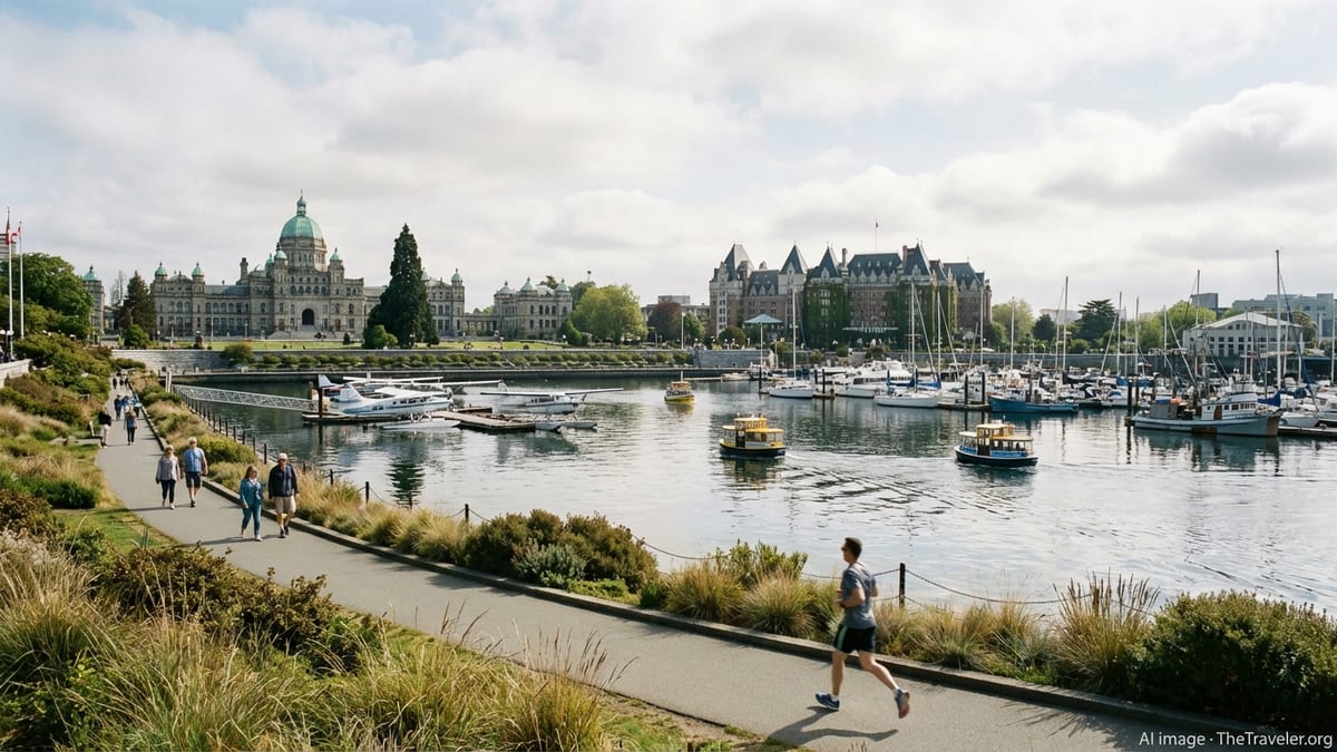
Parliament Buildings and the Legislative Precinct
The domed British Columbia Parliament Buildings anchor the south side of the Inner Harbour and are a natural starting point for orienting yourself. The lawns, statues, and waterfront vistas around the Legislative Precinct provide a sweeping first impression of Victoria’s setting, framed by boats, distant hills, and the grand facade of the Fairmont Empress across the water.
1. British Columbia Parliament Buildings
Begin on the broad lawns in front of the Parliament Buildings, where you can take in the full scale of the late nineteenth-century architecture and its central dome. The buildings are ringed by pathways, flowerbeds in season, and views across the harbour to the floatplane docks and marinas. Even without going inside, the exterior is a highlight at any time of day.
Walk around the perimeter to notice the stonework, statues, and the important presence of Indigenous art and interpretive signs that point to the much older history of these lands. In the evening, thousands of white lights trace the outline of the buildings, making this one of the most atmospheric spots in the city for a twilight stroll or night photography.
2. Confederation Garden Court and Harbour Viewpoints
Just beside the Parliament Buildings, small landscaped spaces and viewing areas give slightly different perspectives on the Inner Harbour. Confederation Garden Court and adjacent walkways offer benches, shade trees, and good vantage points for watching harbour ferries zigzag between docks. It is a quiet place to pause with a coffee in the morning before the main waterfront fills with visitors.
From these viewpoints you can also look back toward the Royal BC Museum and nearby hotels, getting a sense of how compact and walkable the district really is. Use this moment to orient yourself to the David Foster Harbour Pathway signs, which will guide you along the shoreline later in the route.
The Empress, Causeway, and Museum District
From the Legislative Precinct, it is a short walk across Belleville Street to reach the city’s most photographed hotel, the Fairmont Empress, and the lively Causeway promenade below. This central section of the Inner Harbour is where you will likely spend the most time taking photos, listening to buskers in the warmer months, and watching the constant movement of boats and seaplanes.
3. Fairmont Empress and the Inner Harbour Causeway
Facing the water with its ivy-draped exterior and steep rooflines, the Fairmont Empress has symbolized Victoria’s tourism era for more than a century. Even if you are not staying or booking afternoon tea, it is worth walking up to the front entrance to appreciate the architecture and then circling around the hotel to glimpse its gardens and harbour-facing terraces.
From the Empress, descend to the Inner Harbour Causeway, the broad lower-level walkway lining the marina. In late spring through early fall this promenade hums with local artists, musicians, and food vendors, and in winter it becomes a calmer place for contemplative walks, framed by seasonal lights. Wide views across to the Songhees shoreline, the Parliament Buildings, and the marina make this one of the most photogenic sections of the route.
4. Royal BC Museum and Thunderbird Park
A block inland from the Empress along Belleville Street, the Royal BC Museum and the adjacent Thunderbird Park form an essential cultural stop on your walk. The museum is known for its in-depth exhibits on natural history, Indigenous cultures, and the province’s social history, and it can easily occupy several hours if you have the time.
Even on a tighter schedule, step into Thunderbird Park, where carved poles and historic structures stand in a small green space surrounded by city buildings. Interpretive signs help explain the history and cultural significance of the works, many of which relate to the First Nations of the coast. This stop brings important context to the harbour landscape you are walking through.
Steamship Terminal, Seaplanes, and the David Foster Harbour Pathway
Continuing west along Belleville Street, you reach the transportation hub of the Inner Harbour: a cluster of ferry terminals, seaplane docks, and marina facilities. Here the city’s past as a maritime gateway overlaps with its present-day role as a jumping-off point for trips across the Salish Sea, while the David Foster Harbour Pathway starts to carry you closer to the waterline.
5. Steamship Terminal, Seaplane Base, and Causeway Lookouts
The historic Steamship Terminal building houses transport services and visitor facilities, set just above the water where ferries and whale-watching boats come and go. Strolling past its arches and windows, you will often hear boarding calls and see travellers queuing for sailings to nearby coastal towns or to Washington State, which underscores how connected this compact harbour is to the wider region.
Beside the terminal and along the edge of the marine docks, platforms and railings provide clear views of floatplanes landing and taking off. These small aircraft are a defining feature of the harbour skyline, rising and descending in front of the Parliament Buildings and the Empress. Pause here to watch a few departures, then follow the signed David Foster Harbour Pathway as it begins to bend south and west around the point.
6. Laurel Point and the David Foster Harbour Pathway
Further along the shoreline, the David Foster Harbour Pathway leads you toward Laurel Point, a grassy headland with panoramic views back to downtown. The path here is wide, mostly level, and popular with locals out for a jog or an everyday stroll, which gives you a sense of the harbour as a lived space rather than just a visitor attraction.
From Laurel Point you can look across to the Songhees side of the harbour and trace the next section of your walk. Informal viewpoints, benches, and occasional public art pieces invite you to linger, especially in the late afternoon when the light softens on the city’s brick and stone facades. When you are ready, continue around the point toward the colourful flotilla of Fisherman’s Wharf.
Fisherman’s Wharf and the Working Harbour
Southwest of the main Inner Harbour, Fisherman’s Wharf provides a different, more casual angle on Victoria’s waterfront life. Here, floating homes, fishing boats, and small food kiosks create a cheerful jumble of colour and activity, especially in the warmer months. It is still within easy walking distance of the Legislative Precinct, yet it feels like a small maritime village of its own.
7. Fisherman’s Wharf Floating Village
At Fisherman’s Wharf, the boardwalk loops around clusters of vividly painted float homes, tour boats, and working vessels. Walking the docks lets you see the harbour from just above the waterline, with reflections of houseboats, masts, and passing water taxis shimmering below. The area can be lively at midday, but quiet mornings and evenings reveal its more everyday character.
Food stands and small eateries, which change from year to year, typically offer casual fare such as fish and chips, ice cream, and seafood snacks. This makes Fisherman’s Wharf a convenient place for a meal break before you retrace your steps to rejoin the David Foster Harbour Pathway or head inland through the James Bay neighbourhood toward your next harbour viewpoint.
Songhees Walkway and Panoramic Harbour Views
Crossing to the north side of the Inner Harbour gives you a complementary perspective on many of the buildings and landmarks you saw up close earlier in the day. The Songhees shoreline, sometimes called the Songhees or West Song Walkway, forms a largely continuous waterfront path with long, open views back toward downtown, the Parliament Buildings, and the Empress.
8. Songhees Walkway and West Bay Views
To reach the Songhees side, make your way to the Johnson Street Bridge and cross over the water, then follow the signed harbourside path west. The Songhees Walkway is a mostly flat, paved route lined with condos, parks, and small marinas, and it is widely used by local walkers, runners, and cyclists. Despite the residential development, there are frequent stretches where you are walking right above the rocky shoreline with unobstructed views.
Benches along the way invite you to sit and watch the choreography of the harbour: kayakers crossing the channel, tugs nudging barges, harbour ferries looping in tidy arcs, and cruise ships or navy vessels appearing in the distance. Clear sightlines back to the Parliament Buildings and the Empress also make this one of the best places to photograph Victoria’s skyline without crowds in the frame.
9. Johnson Street Bridge and Inner Harbour Gateway
As you return toward downtown, the Johnson Street Bridge serves as a literal and symbolic gateway between the Inner Harbour and the Upper Harbour. The current bascule bridge opened in 2018 and is known for its striking, modern profile and blue-toned lighting after dark. Separate paths for pedestrians and cyclists make it straightforward to cross on foot while taking in the industrial and maritime scenery on either side.
From the mid-span, you can look south to the cluster of historic buildings around Wharf Street and Bastion Square, and north toward shipyards and working docks that illustrate Victoria’s ongoing relationship with the sea. Once you have crossed back to the downtown side, follow the harbour edge briefly before climbing up toward Old Town, where nineteenth-century warehouses have been adapted into today’s shops, restaurants, and offices.
Old Town, Bastion Square, and Chinatown
The final segment of your Inner Harbour walk lifts you slightly away from the water into Old Town and Chinatown, districts that grew alongside the harbour’s early trading and gold-rush eras. Narrow lanes, brick warehouses, and heritage shopfronts linger here, many of them carefully restored, and the area rewards slow wandering as much as any single landmark.
10. Bastion Square and the Old Town Waterfront
Bastion Square, reached via a short climb from Wharf Street, occupies the site of Victoria’s original fort and is now a pedestrian plaza framed by historic buildings. Seasonal markets, art events, and small patios keep the square active, while the staircase at its western edge offers another fine view over the Inner Harbour and the Songhees shoreline. This is a good place to reflect on how much of the city’s commercial life once revolved directly around the waterfront below.
From Bastion Square, continue through the surrounding Old Town streets, where brick warehouses and former trading houses now host boutiques, cafes, and small galleries. The pattern of narrow lanes and courtyards hints at the dense, improvised cityscape that supported shipping, warehousing, and migrant communities from the mid-nineteenth century onward. When you are ready, angle northeast toward Canada’s oldest Chinatown to complete the loop.
Bonus Stop: Fan Tan Alley and Chinatown
While slightly beyond the immediate waterfront, Fan Tan Alley and the surrounding blocks of Chinatown are close enough to belong on any comprehensive Inner Harbour walking route. Fan Tan Alley, known as one of the narrowest streets in Canada, threads between tall brick walls and opens into a series of tiny shops and workspaces. Walking through it offers a vivid sense of how businesses once fit into every available corner of this compact district.
Broader nearby streets and courtyards display Chinese-influenced architectural details, hanging lanterns, and heritage facades that speak to the long-standing presence of Chinese Canadians in Victoria’s history. From here, it is a short, mostly downhill stroll back toward Government Street and the harbour, where your loop can end near the Empress or the Parliament Buildings.
The Takeaway
Victoria’s Inner Harbour rewards anyone willing to explore on foot. By following this ten-stop route, you can experience its ceremonial side at the Parliament Buildings, its cultural depth at the Royal BC Museum and Thunderbird Park, its working character at Fisherman’s Wharf and the Songhees shoreline, and its layered history in Old Town and Chinatown. The overall distance is manageable for most visitors, yet the variety of views, stories, and neighbourhoods along the way make it feel like a much larger journey.
Whether you have a full day or just a few hours between ferry connections or cruise excursions, you can adapt this loop to match your schedule. Focus on the waterfront highlights if you want open vistas and iconic photos, or linger in museums, markets, and side streets if you prefer context and atmosphere. However you pace it, walking the Inner Harbour is one of the most satisfying ways to understand why Victoria consistently appears on lists of Canada’s most livable and visitable cities.
FAQ
Q1. How long does it take to walk a full Inner Harbour loop with these 10 stops?
Most visitors can complete the route in three to five hours at a relaxed pace, including time for photos, coffee breaks, and short museum or gallery visits.
Q2. Is the Inner Harbour walking route suitable for strollers and wheelchairs?
Much of the route follows flat, paved paths like the Causeway, David Foster Harbour Pathway, and Songhees Walkway, but there are a few slopes and stairs. Ramps and alternative streets are available in most cases, so with some advance planning it can work for many mobility levels.
Q3. When is the best time of year to walk around Victoria’s Inner Harbour?
Late spring through early fall offers the warmest weather, longest days, and most activity on the Causeway and at Fisherman’s Wharf. Winter and early spring are quieter but can be rewarding for peaceful walks and stormy harbour views if you dress for cool, damp conditions.
Q4. Is it safe to walk the Inner Harbour area at night?
The immediate Inner Harbour, Government Street, and Songhees Walkway are generally busy and feel reasonably safe into the evening, especially during peak season. As in any city, stay aware of your surroundings, avoid poorly lit side streets, and follow local advice from your accommodation about current conditions.
Q5. Can I shorten the route if I have only a couple of hours?
Yes. A compact loop linking the Parliament Buildings, Empress and Causeway, Steamship Terminal, and a short stretch of the David Foster Harbour Pathway, then back through Old Town, gives you a strong overview in about two hours.
Q6. Are guided tours available around the Inner Harbour?
Local operators frequently offer walking tours that cover the Legislative Precinct, Old Town, and Chinatown, as well as themed experiences such as food tours or ghost walks. These can be a good way to add historical and cultural context to the route described here.
Q7. Where can I find restrooms along the route?
Public facilities are typically available near the Parliament Buildings, around the main harbour promenades, in some parks, and inside major attractions such as the Royal BC Museum. Many cafes and restaurants along the way provide facilities for customers as well.
Q8. What should I wear and bring for a day walking the Inner Harbour?
Comfortable walking shoes, a light waterproof or windproof layer, and sun protection are recommended in most seasons. A reusable water bottle, small backpack, and camera or phone for photos will also be useful.
Q9. Can I combine this walk with whale-watching or harbour tours?
Yes. Several whale-watching and sightseeing operators depart from docks along the Inner Harbour and Fisherman’s Wharf. You can easily schedule a tour in the middle of your walking day and resume the route afterward.
Q10. How do cruise passengers fit this Inner Harbour route into a short port call?
Passengers docking at Ogden Point can walk or shuttle to the Legislative Precinct, then follow a condensed loop that covers the Parliament Buildings, Empress and Causeway, Steamship Terminal, and Old Town, with optional detours to Fisherman’s Wharf or Chinatown if time permits.