
Long before visitors gazed in awe at the blue depths of Crater Lake, a towering volcano dominated this corner of southern Oregon. Mount Mazama, now reduced to a broken ring of cliffs encircling an impossibly clear lake, has one of the most dramatic life stories of any peak in North America.
From cataclysmic eruptions and deep cultural meaning to its ongoing volcanic potential, these 12 fascinating facts reveal why Mount Mazama remains a place of scientific intrigue and quiet power.
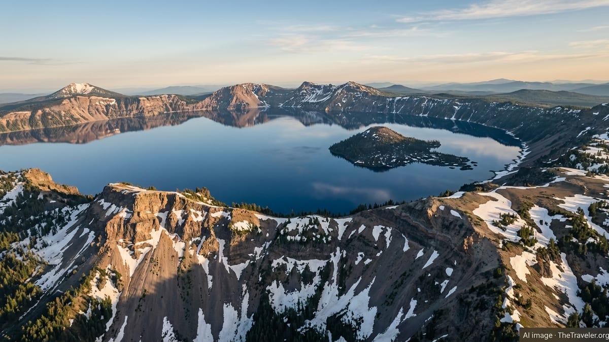
1. Mount Mazama Was Once One of the Giants of the Cascades
Today, visitors see only the shattered rim and serene waters of Crater Lake, but for most of its life Mount Mazama rivaled the highest volcanoes in the Cascade Range. Its former bulk and height are key to understanding just how extraordinary its final eruption was.
From Summit Giant to Sunken Rim
Before its collapse, Mount Mazama is estimated to have risen to roughly 12,000 feet above sea level, placing it among the tallest peaks in Oregon and the broader Cascade Volcanic Arc. For context, that would have made it comparable in stature to Mount Hood and higher than many of its volcanic neighbors.
The mountain sprawled as a broad, composite volcano built from overlapping cones and shields over hundreds of thousands of years. Its slopes were mantled in ice during repeated glacial periods, and deep U-shaped valleys were carved into its flanks by glaciers that later filled with lava from younger eruptions. The Crater Lake cliffs you see today are cross-sections of this long volcanic and glacial history.
A Volcano With Many Lives
Geologists interpret Mount Mazama not as a simple, single cone but as a complex volcanic edifice that evolved in stages. Early activity built nearby peaks such as Mount Scott, just east of today’s caldera, before the main Mazama cone shifted westward and grew to its full height.
This long lifespan, thought to extend back roughly 400,000 to more than 420,000 years, allowed Mazama to accumulate an enormous volume of lava and volcanic rock. By the time of its final eruption, the volcano’s upper half rested on a large, silica-rich magma chamber, setting the stage for catastrophic failure.
2. A Cataclysmic Eruption Caused the Mountain to Vanish
Crater Lake exists because Mount Mazama quite literally collapsed into itself. The event that transformed a towering volcano into a vast basin ranks among the most powerful eruptions on Earth in the past 12,000 years.
The Climactic Eruption About 7,700 Years Ago
Around 7,700 years ago, in an eruption that unfolded over a matter of days, Mazama expelled a staggering volume of magma. Modern studies estimate that tens of cubic miles of material were blasted or flowed out, with the eruption column rising high into the stratosphere and pyroclastic flows racing down every valley radiating from the volcano.
As magma was rapidly withdrawn from the underlying chamber, the overlying edifice could no longer support itself. Large sections of the summit and upper slopes collapsed inward in a series of massive block failures, creating a depression roughly 4,000 feet deep. This newly formed caldera stretched about 5 by 6 miles across at the rim, instantly erasing the mountain’s former summit profile.
An Eruption Felt Across a Continent
The scale of the climactic eruption was so great that its ash blanket forms a key time marker in soils, sediments, and lake beds across western North America. Fine ash from Mazama has been identified in at least eight U.S. states and several Canadian provinces, reaching as far as parts of Alberta and southern British Columbia.
This ash fall and the vast sheets of pumice and pyroclastic flow deposits reshaped the surrounding landscape for tens of miles. Valleys were choked, forests were obliterated, and thick pumice blankets still underlie many of the park’s trails and viewpoints today, subtly influencing which plants can grow where.
3. The Caldera Slowly Filled to Become Crater Lake
Visitors often imagine Crater Lake forming instantly when the mountain collapsed, but the water that gives the caldera its name arrived more slowly. The filling of this natural basin is a story of climate, hydrology, and time working together on a massive volcanic wound.
No Rivers Flow In or Out
One of the most remarkable facts about Mount Mazama’s caldera is that Crater Lake has no major streams feeding it and no surface rivers draining it. Instead, the lake is almost entirely sustained by direct precipitation in the form of snow and rain, along with a balance of evaporation and groundwater seepage.
Over centuries after the eruption, winter snowpack and seasonal rains accumulated behind the caldera walls. As the basin gradually filled, the water level rose until it reached an equilibrium where inflow from precipitation roughly matched outflow through evaporation and slow leakage through porous deposits along the rim.
Among the Deepest and Clearest Lakes in the World
The collapse of Mount Mazama left behind an exceptionally deep basin. Today Crater Lake reaches a maximum depth of just under 2,000 feet, making it the deepest lake in the United States and one of the deepest in the world.
Because the lake is fed almost exclusively by precipitation, with minimal sediment-laden inflow, its waters are famously clear and vividly blue. Water clarity tests often reveal exceptional visibility, and the rich blue hue is a result of light penetrating deeply and shorter wavelengths scattering back to the observer.
4. Mount Mazama Still Hides Volcanoes Beneath the Water
To many visitors, Mount Mazama appears quiet and finished, with its activity consigned to ancient history. Modern seafloor-style surveys of the caldera, however, show that volcanic processes continued after the collapse and that some of the mountain’s youngest features are completely hidden from casual view.
Wizard Island Is Only the Most Obvious Cone
Wizard Island, the conical island rising from the lake’s western side, is the best known post-collapse volcano inside the caldera. It is a cinder cone built by relatively modest eruptions that occurred after the main magma chamber had emptied and the caldera had begun to stabilize.
The cone’s summit crater and its lava flows record a later, quieter phase of Mazama’s life. These eruptions did not rebuild the mountain to anything near its former height but show that magma was still finding pathways upward beneath the flooded caldera floor.
Hidden Domes and Cones on the Lake Bed
High-resolution mapping of the caldera floor using multibeam sonar and other tools has revealed additional volcanic features submerged beneath hundreds of meters of water. These include smaller cones, lava domes, and a central platform that never rose high enough to break the lake’s surface.
These underwater structures, along with lava interacting with lake water to form pillow-like textures, illustrate that the period after collapse was geologically active. Crater Lake today is not just a water-filled hole but a complex volcanic landscape partly disguised by its deep, clear waters.
5. Ash From Mazama Is a Time Marker Across the Pacific Northwest
One of the most scientifically valuable legacies of Mount Mazama is the vast sheet of ash and pumice it spread across western North America. This tephra blanket acts as a geological timestamp, helping researchers date other events and reconstruct ancient environments.
Mazama Ash in Lakes, Peat Bogs, and Soils
The distinctive chemical signature and pale color of Mazama ash allow it to be identified far beyond Oregon. Layers of fine volcanic particles from the climactic eruption have been found in lake sediments, peat bogs, and soil profiles across multiple states and Canadian provinces.
Because the eruption was brief in geological terms, the Mazama ash layer pinpoints a moment in time. When scientists find this ash in a core from a lake bed or wetland, they can associate the surrounding organic material with an approximate age of around 7,700 years, providing an anchor for climate and ecological reconstructions.
A Window Into Past Climates and Ecosystems
The ash blanket does more than simply date sediments. The way it lies within soil profiles, the pollen grains preserved alongside it, and the plant and animal remains above and below it all help reveal how landscapes reacted to the eruption and how ecosystems changed through the Holocene.
In places close to Mount Mazama, the ash and pumice layers can be tens of feet thick, dramatically altering drainage patterns and soil development. Farther away, a thin dusting may be the only sign of the eruption, yet even this faint record becomes invaluable in piecing together the environmental story of the Pacific Northwest.
6. The Klamath People Preserve Powerful Stories of the Eruption
For the Indigenous Klamath people, Mount Mazama and Crater Lake are not just geologic features. They are central characters in a sacred landscape, remembered in oral traditions that may echo real observations of the ancient eruption.
A Battle Between Spirit Beings
Klamath stories describe a dramatic conflict between powerful spirit beings associated with the underworld and the sky, often interpreted by scholars as symbolic references to the volcanic eruption and the destruction of the mountain. In many tellings, the mountain is broken and a deep hole is left behind, which eventually fills with water.
Although the details vary among versions, the narratives emphasize themes of imbalance, destruction, and eventual renewal, mirroring the cycle of eruption, collapse, and the later emergence of a beautiful, life-sustaining lake. The Klamath name for Crater Lake, often translated in English as “sacred water” or similar concepts, reflects this deep spiritual connection.
Oral Tradition as Geological Memory
Anthropologists and geologists have long noted that Indigenous oral histories from many regions sometimes contain vivid descriptions of natural events such as eruptions, earthquakes, and floods. The Klamath stories about the transformation of Mount Mazama are frequently cited as one of the most compelling examples of this phenomenon in North America.
While it is difficult to directly equate mythic narratives with specific geologic dates, the parallels between the stories and the evidence of a catastrophic eruption are striking. For travelers, recognizing these cultural perspectives adds depth to any visit, reminding us that Mazama’s story has human as well as geologic dimensions.
7. Mount Mazama Is Dormant, Not Extinct
Despite its tranquil appearance, the Mount Mazama system is not considered geologically dead. Modern monitoring and hazard assessments treat it as a dormant volcano that could, one day, erupt again on a smaller scale.
Subtle Signs of an Active System
After the climactic eruption, all known volcanic activity has been confined within the caldera itself. The youngest features, such as Wizard Island and other submerged cones, formed as magma continued to intrude and erupt beneath the basin. Although no eruptions have occurred for several thousand years, Mazama still sits within an active segment of the Cascade Volcanic Arc.
The area also shows signs of ongoing tectonic and magmatic processes, including regional faulting around the volcano and subtle geothermal activity. These clues support the view that magma still resides at depth, even if it has not approached the surface in recent millennia.
Modern Monitoring and Hazards
The United States Geological Survey and partner agencies monitor the broader Crater Lake region as part of the Cascade volcano network. Seismic instruments, geodetic measurements, and other tools help detect small earthquakes, ground deformation, or thermal changes that could herald renewed activity.
Most scenarios considered by scientists involve eruptions much smaller than the one that created the caldera, likely limited to localized vents inside or near the lake. Even modest activity could have serious local impacts, including ash fall, lava interacting with lake water, and potential debris flows down nearby valleys. For travelers, this underscores that the serene beauty of Crater Lake rests atop a living volcanic system.
8. Pumice Deserts and Eroded Spires Reveal the Eruption’s Aftermath
Hiking around the remnants of Mount Mazama, visitors encounter more than a dramatic lake view. The surrounding landscape is dotted with haunting landforms that testify to the power and aftermath of the climactic eruption.
The Stark Beauty of the Pumice Desert
North of the caldera rim lies an area known informally as the Pumice Desert, a broad, pale expanse where plant life struggles in the porous, nutrient-poor deposits left by the eruption. Here, thick layers of frothy volcanic rock blanket the ground, forming a striking contrast to the dark forests that ring much of the park.
The open, almost lunar appearance of this area illustrates how difficult it is for ecosystems to reclaim ground buried in lightweight, fast-draining pumice. Over thousands of years, hardy species have begun to colonize the surface, but the process remains slow, giving travelers a rare glimpse of a landscape still healing from a prehistoric catastrophe.
Volcanic Fumarole Pipes Turned to Stone
Elsewhere on the flanks of Mount Mazama’s legacy, erosion has sculpted spires and pinnacles out of once-buried volcanic deposits. These slender towers formed where hot gases rose through thick ash and pumice, cementing vertical channels into hard rock. As surrounding material eroded away, the tougher fumarole pipes remained, standing like stone chimneys against the sky.
These formations, found in certain drainages and along river valleys, offer a close-up look at the inner plumbing of volcanic deposits. They remind visitors that the ground beneath their feet was once a chaotic landscape of ash clouds, searing flows, and venting gases.
9. Crater Lake’s Color and Clarity Depend on a Delicate Balance
The deep blue of Crater Lake, filling the caldera of Mount Mazama, is one of its most iconic features. Yet that color and clarity are not guaranteed forever. Subtle shifts in climate and ecology are already leaving their mark on this volcanic basin.
Clean Water From Sky to Lake
Because the lake has no major inflowing rivers, it receives little sediment or pollution from distant sources. Most of its water arrives as snow that melts and trickles directly down steep inner walls, picking up very little material on its journey.
This unusual hydrologic setup is a big reason why light can penetrate so deeply into the water column, enhancing the lake’s vivid color. Any substantial increase in sediment or nutrients, whether from natural processes or human influence, could change that optical clarity and subtly alter the visitor experience.
Climate Change and a Sensitive Volcanic Lake
Long-term monitoring has shown shifts in Crater Lake’s snowfall patterns and water temperatures over the past century. Warmer conditions can reduce average snowpack, change the timing of snowmelt, and potentially encourage more biological activity in the water.
More algae growth, for example, could gradually mute the intense blue color by scattering light differently. Although Crater Lake remains among the cleanest and clearest large lakes in the world, scientists watch these trends closely. The legacy of Mount Mazama thus intersects with one of today’s most pressing global issues, as a caldera lake responds to a changing climate.
10. Mount Mazama Anchors a Crossroads of Tectonic Provinces
Mount Mazama did not arise in isolation. Its location at the intersection of volcanic and tectonic trends gives the caldera and its surroundings a complex geologic backdrop, enriching the story for travelers who want to look beyond the rim.
Where Arc Volcanoes Meet a Graben
Mazama sits within the Cascade Volcanic Arc, a chain of volcanoes fed by the subduction of an offshore oceanic plate beneath the edge of North America. At the same time, it lies along the Klamath graben, a north-northwest-trending basin formed by crustal stretching and faulting.
This meeting of a volcanic arc with a fault-bounded basin helps focus magmatism in the Mazama region. Over at least the last several hundred thousand years, magma from depth has repeatedly found pathways upward here, producing not only the main Mazama edifice but also a host of smaller shield volcanoes, cinder cones, and lava fields scattered across the surrounding high country.
A Transition Toward the Basin and Range
To the east, the landscape grades into the Basin and Range Province, a vast region of alternating mountain ranges and down-dropped valleys created by crustal extension. Seen from a viewpoint along the caldera rim, the broad, stepped horizons in the distance hint at this tectonic architecture.
For visitors, understanding this context transforms Mount Mazama from an isolated scenic spot into a keystone of western North American geology. It stands at a literal and figurative crossroads where subducting plates, stretching crust, and surging magma converge.
11. Scientific Study Here Helped Define What a Caldera Is
Mount Mazama and Crater Lake have played an outsized role in shaping scientific understanding of volcanic collapse. The clarity of the caldera’s form and the accessibility of its exposed layers made it a natural classroom for early geologists and a continuing reference point today.
From Early Surveys to Global Recognition
In the early 20th century, pioneering geological surveys of Crater Lake meticulously mapped the caldera walls, lava flows, and volcanic deposits radiating from Mount Mazama. These studies highlighted how the mountain’s summit had disappeared and how the remaining ring of cliffs framed a deep basin rather than a simple explosion crater.
As geologists compared Mazama with other volcanic depressions around the world, Crater Lake became a textbook example of a collapse caldera. The term itself, now widely applied to large volcanic basins in places from Iceland to Indonesia, owes much of its modern usage to detailed work done here.
A Natural Laboratory for Volcano Research
Today, Mount Mazama continues to attract researchers interested in magma evolution, eruption dynamics, and hazards assessment. The multicolored layers in the caldera walls record changing magma compositions and eruption styles over hundreds of thousands of years, while the post-collapse cones within the lake offer insight into how volcanic systems recover after major failures.
Ongoing studies also explore sedimentation on the lake floor, landslide deposits along the inner walls, and how volcanic landscapes respond to long-term climatic shifts. For science-minded travelers, every viewpoint becomes a window into a sophisticated natural archive.
12. Visiting Mount Mazama Connects Scenic Beauty With Deep Time
Standing on the rim of Crater Lake, it is easy to be captivated purely by the scenery. Yet every view into the caldera of Mount Mazama also offers a chance to contemplate deep time, sudden catastrophe, and the resilience of landscapes and cultures.
A Traveler’s Experience of a Vanished Peak
As you circle the rim by road or trail, each overlook reveals a different facet of the caldera: sheer walls where lava layers stack in colorful bands, sheltered coves cut into the rim, or sweeping vistas where Wizard Island seems to float in a sea of blue. These views make it easier to imagine the original cone of Mount Mazama arching thousands of feet above the point where your eyes now trace the rim.
Boat tours on the lake, when operating, bring visitors closer to the inner walls and the rocky slopes of Wizard Island, where coarse lava blocks and cinders record the volcano’s final bursts of activity. Even a quiet moment watching clouds reflected on the water becomes more meaningful when you know that this tranquil scene sits atop one of the Cascades’ most powerful eruption sites.
Respecting a Living, Sacred Landscape
For many, a visit to Mount Mazama’s caldera is also a chance to consider how natural wonders intersect with cultural meaning and present-day stewardship. The area remains sacred to the Klamath and other Indigenous peoples, and its designation as a national park reflects a broader recognition of its value.
Staying on designated trails, treading lightly on fragile pumice surfaces, and listening to both scientific interpretation and Indigenous voices all help ensure that Mount Mazama’s story can continue to educate and inspire. Travelers who approach the caldera with curiosity and respect become part of an ongoing relationship with a landscape that is both ancient and alive.
The Takeaway
Mount Mazama is far more than the backdrop to a postcard-perfect lake. It is a vanished giant whose catastrophic collapse created one of the world’s most striking calderas, a natural laboratory that shaped how scientists understand volcanic processes, and a sacred landscape woven into the traditions of the Klamath people. From hidden underwater cones and far-traveled ash to subtle signs of continued volcanic potential, its story spans deep geologic time and resonates with contemporary concerns about climate and hazards.
For travelers, learning these 12 fascinating facts transforms a visit from a simple sightseeing stop into a journey through fire, ice, and cultural memory. To stand on the rim of Crater Lake is to stand at the edge of a story still unfolding, written in lava flows, clear water, and the enduring presence of a mountain that no longer exists in the way it once did.
FAQ
Q1. Where is Mount Mazama and Crater Lake located?
Mount Mazama and the caldera that holds Crater Lake are in southern Oregon, within Crater Lake National Park in the southern Cascades.
Q2. Is Mount Mazama considered an active volcano?
Mount Mazama is classified as dormant rather than extinct. There have been no recent eruptions, but the volcanic system is still considered capable of future activity.
Q3. How deep is the caldera and Crater Lake?
The caldera is roughly 4,000 feet deep from original summit to floor, and Crater Lake itself reaches nearly 2,000 feet in water depth at its deepest point.
Q4. When did Mount Mazama’s big eruption occur?
The climactic eruption that caused the summit to collapse and formed the caldera took place about 7,700 years ago, during the Holocene epoch.
Q5. Can visitors see evidence of the eruption today?
Yes. Steep caldera walls, pumice-covered plateaus, eroded spires, and the presence of Wizard Island and other volcanic features all record the eruption’s power and aftermath.
Q6. Does any water flow into or out of Crater Lake?
Crater Lake has no major rivers entering or exiting. It is primarily fed by rain and snow and balanced by evaporation and slow seepage through the surrounding rock.
Q7. Why is Crater Lake so blue and clear?
The lake’s water comes mostly from direct precipitation, which is low in sediment and pollutants. This clarity allows light to penetrate deeply and enhances its intense blue color.
Q8. Are there volcanoes on the floor of the caldera?
Yes. In addition to Wizard Island, mapping has revealed submerged cones, domes, and lava platforms on the caldera floor that formed after the main collapse.
Q9. What role do Indigenous stories play in understanding Mount Mazama?
Klamath oral traditions describe a great mountain’s destruction and the creation of a deep water-filled hole, offering powerful cultural perspectives that may echo memories of the eruption.
Q10. Is it safe to visit Mount Mazama and Crater Lake today?
Yes. The area is considered safe for visitors, and any signs of renewed volcanic unrest would be closely monitored by scientists and communicated to park managers and the public.