
More news on this day
A powerful 7.1 magnitude earthquake struck off the coast of Malaysia’s Sabah state in the early hours of February 23 local time, jolting popular beach towns and island resorts across northern Borneo and briefly plunging one of Southeast Asia’s emerging tourism hotspots into panic, even as authorities reported no tsunami threat and only minor damage.
Rare Deep Quake Beneath the Sulu Sea
The United States Geological Survey said the quake hit at 16:57 UTC on Sunday, February 22, at a depth of about 620 kilometers beneath the Sulu Sea, roughly 55 kilometers north-northwest of Kota Belud and less than 100 kilometers from the Sabah capital Kota Kinabalu. Seismologists described it as an unusually deep, high-magnitude event in a region that rarely experiences strong earthquakes.
Despite its strength, the depth of the rupture meant that shaking at the surface was significantly reduced compared with a shallow quake of similar magnitude. Early assessments from Malaysian and international agencies rated the likelihood of casualties and major structural damage as low, though this did little to calm nerves among residents and visitors roused from their sleep along Sabah’s west and northern coasts.
Malaysia lies outside the volatile Pacific Ring of Fire and typically experiences only mild tremors from distant regional quakes. To have a 7.1 magnitude event directly associated with Sabah makes this one of the strongest earthquakes ever instrumentally recorded in or near the country, surpassing events that struck the state in the early 20th century and surpassing, in magnitude, the 2015 Ranau earthquake that killed climbers on Mount Kinabalu.
Experts noted that the shock originated within the downgoing slab of the Philippine Sea plate, far beneath Borneo, rather than along a shallow crustal fault. Such deep intraslab earthquakes are rare under Malaysia but can transmit vibrations across very large areas, explaining why the tremor was felt not only across Sabah but also in parts of Sarawak, Brunei and the southern Philippines.
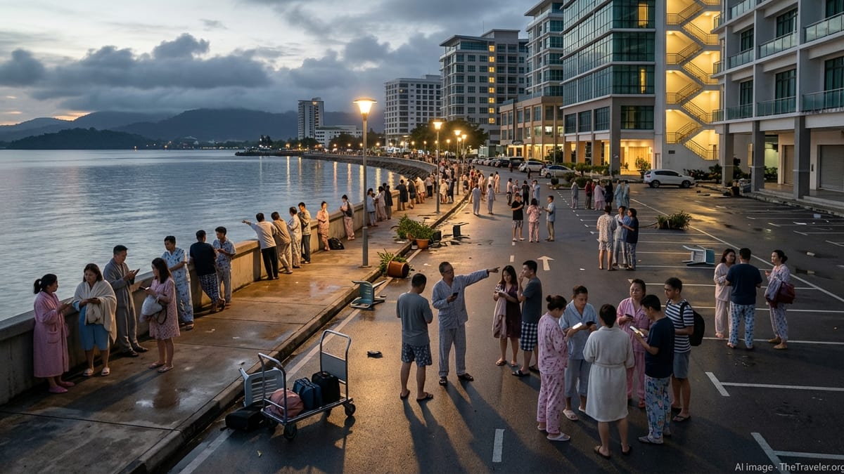
Panic in Coastal Resorts and Island Getaways
The quake struck just after midnight local time, when many visitors in Kota Kinabalu, the resort town of Kota Belud, and beach communities along the West Coast Division were asleep in seafront hotels or hilltop homestays. Witnesses described a low rumbling followed by several seconds of strong, rolling motion that rattled windows, set chandeliers swaying and triggered car alarms.
In Kota Kinabalu’s waterfront district, hotel staff ushered guests down stairwells and into open-air car parks as part of emergency procedures. Some tourists, barefoot and clutching passports or mobile phones, waited for nearly an hour as management teams checked for damage and monitored official advisories about possible aftershocks or tsunami risk.
On the nearby resort islands of Manukan, Gaya and Sapi, popular with day-trippers and divers, guests reported beds shaking and wooden structures creaking but said the power stayed on and communications were largely uninterrupted. Several beachfront operators temporarily moved guests away from the waterline until authorities confirmed that the depth of the earthquake made a tsunami highly unlikely.
Along the Kudat Peninsula and in smaller fishing and tourism villages north of Kota Belud, residents rushed out of stilt houses and low-rise shop lots, fearing a repeat of the deadly 2015 mountain landslides that followed a smaller but shallower quake near Ranau. This time, however, there were no immediate reports of rockfalls or major structural failures in the upland areas that attract hikers and nature lovers.
Authorities Move Quickly to Reassure Tourists
Within an hour of the tremor, Malaysia’s meteorological and disaster management agencies issued reassurances that no tsunami warning had been triggered and that the deep focus of the earthquake significantly reduced the likelihood of serious damage. The country’s meteorological department placed the magnitude slightly lower than international agencies but concurred that the epicenter lay offshore, far beneath the sea.
Sabah state officials said early inspections at key tourism nodes, including Kota Kinabalu International Airport, Jesselton Point ferry terminal and major beachfront hotels, found no structural damage. Airport operations continued as scheduled, and ferries to nearby islands resumed normal service after brief precautionary checks of piers and jetties.
Tourism authorities acknowledged, however, that the psychological impact of the quake was considerable. Sabah has invested heavily in branding itself as a safe, nature-focused destination for diving, trekking and family beach holidays. The sight of tourists gathered anxiously in hotel car parks and on darkened streets, sharing live videos of shaking rooms and swaying lamps, put state officials under pressure to demonstrate that emergency plans worked.
Local councils coordinated with hotel managers and tour operators to disseminate verified information in multiple languages, including English, Mandarin and Korean, given the diverse visitor profile on the ground. Hotlines were set up to field questions from concerned families abroad, and consular staff from several countries began gathering impact reports from their nationals in Sabah’s main resort zones.
Local Communities Balance Fear and Resilience
For many Sabahans, especially those living along the coast and in rural districts where tourism, fishing and small-scale agriculture are intertwined, the sudden quake triggered a mix of fear and stoic acceptance. Elder residents recalled previous tremors and spoke of traditional instincts to head to open ground when the earth moves, a reflex now reinforced by modern disaster awareness campaigns.
In popular homestay villages around Kota Belud and Tuaran, hosts guided guests into nearby fields or parking areas, distributing sarongs and bottled water while children huddled near their families. Some residents reported minor cracks in older masonry walls and dislodged ornaments in wooden homes on stilts, but there were no immediate indications of serious structural compromise.
Market vendors in Kota Kinabalu’s central area, preparing for the pre-dawn opening of fish and produce stalls, described merchandise toppling from shelves and hanging scales swinging violently for several seconds. By mid-morning, most stalls were back in operation, though conversations frequently returned to the night’s tremor and speculation about whether stronger aftershocks could still arrive.
Religious leaders from mosques, churches and temples in the region offered prayers and gatherings for residents and visitors who felt shaken by the event. Community groups used social media channels to share practical guidance on earthquake safety, reinforcing messages from official agencies about staying away from rumors and seeking updates only from verified sources.
Why a Strong Quake Caused Limited Damage
Despite the panic in tourist hotspots, seismologists emphasized that the very factor that made the quake so widely felt, its considerable magnitude, also played a role in limiting damage, because its energy was released far beneath the surface. Deep earthquakes like this one tend to spread their shaking over large distances while producing lower levels of ground acceleration at any single location compared with shallower events.
Preliminary analyses indicated that shaking intensity in Sabah’s major population centers generally remained in the light to moderate range. Buildings designed primarily for wind and tropical storm loads were still subjected to a noticeable jolt, but not the severe, high-frequency shaking that often causes catastrophic collapses in urban earthquakes along shallow faults.
Malaysia’s building codes have historically placed less emphasis on seismic resistance than those in neighboring countries situated directly along active plate boundaries. Nevertheless, modern reinforced concrete hotels and commercial buildings along Sabah’s coast appear to have withstood the tremor well. Engineers noted that the event serves as an important full-scale test of existing structures and may prompt authorities to further review design standards for taller buildings and critical infrastructure.
There were no immediate reports of significant disruptions to power plants, ports or telecommunications hubs. Minor, localized outages were quickly restored, and mobile networks, heavily relied upon by both tourists and residents, remained largely functional during and after the quake.
Memories of Past Disasters and Future Preparedness
The earthquake inevitably revived memories of the 2015 Ranau quake, which triggered deadly rockfalls on Mount Kinabalu and exposed gaps in disaster preparedness for climbers and rural communities. While the latest event did not unleash similar surface hazards, emergency planners and tourism operators acknowledge that it offers a fresh reminder of Sabah’s underlying seismic risk.
Guides and outfitters operating around Mount Kinabalu and in the Crocker Range reported that they felt the shaking but saw no evidence of new landslides or path blockages on key trekking routes. Park authorities nonetheless dispatched rangers to check popular trails, suspension bridges and visitor facilities at higher elevations, keen to reassure future climbers and avoid the perception of complacency.
Disaster management officials said they intend to review overnight evacuation procedures in hotels and guesthouses, particularly in high-rise properties where stairwell congestion and language barriers can slow the movement of guests. Training for front-line tourism workers, from reception staff to dive guides, is expected to be strengthened so they can better interpret seismic alerts and communicate calmly with anxious visitors.
Urban planners and academics have long urged greater integration of seismic risk into Sabah’s development strategy, noting that even rare events can have outsized economic and reputational impacts on a tourism-dependent region. The latest quake is likely to add weight to calls for more regular drills, updated hazard maps and clearer signage in multiple languages at hotels, ferry terminals and national parks.
Economic Ripples for Sabah’s Tourism Sector
In the immediate aftermath, tourism businesses in Sabah focused on reassuring current guests and assessing potential cancellations. Travel agents reported a surge in queries from overseas clients, particularly for bookings scheduled in the coming weeks for diving in the Tunku Abdul Rahman Marine Park, wildlife trips along the Kinabatangan River and beach stays near Kota Belud and Kudat.
Hotel managers along the Kota Kinabalu waterfront said they expected some short-term cancellations from risk-averse travelers but hoped that clear communication about the lack of serious damage would limit long-term fallout. Many pointed out that flights, ferry operations and most tours continued with minimal disruption, and that iconic attractions, from Mount Kinabalu to offshore coral reefs, remained open.
Economists suggested that the psychological impact of the quake could temporarily affect booking patterns, particularly from markets where media coverage emphasizes the magnitude without explaining the mitigating role of depth and the absence of a tsunami threat. Sabah’s tourism board is likely to respond with targeted campaigns highlighting both the resilience of local infrastructure and the region’s ongoing commitment to visitor safety.
Local businesses, including small guesthouses, dive shops and restaurants, said the event underscored the importance of having basic continuity plans, such as backup power, clear evacuation routes and staff training. Many described the quake as a “wake-up call” that, while frightening, may ultimately leave the industry better prepared for any future seismic surprises.
Regional Tremors Felt Across Borneo and Beyond
Reports from neighboring regions confirmed that the earthquake’s effects were felt far beyond Sabah’s main tourist corridors. In Brunei, residents described light to moderate shaking in Bandar Seri Begawan and coastal districts, prompting some to briefly evacuate high-rise residences. In the southern Philippines, including parts of Mindanao and the Sulu archipelago, people also reported swaying buildings, though no serious damage was recorded.
Communities in Sarawak and parts of peninsular Malaysia noted subtle but distinct tremors, particularly in taller buildings, reinforcing the idea that deep earthquakes can act like a bell rung at the center of a wide region. For travelers unfamiliar with seismic activity in Southeast Asia, social media posts capturing swaying curtains and rippling swimming pool water added to a sense of unease.
Regional monitoring centers worked closely to cross-check magnitude, depth and epicenter data, ensuring consistency in public messaging. The absence of a tsunami threat, confirmed by multiple tsunami warning centers, was repeatedly emphasized, given the sensitivity in coastal communities to any hint of elevated sea levels after major offshore quakes.
As the day progressed, geophysicists began to analyze the event within the broader pattern of seismicity in Southeast Asia, noting its unusual depth beneath the Sulu Sea and the implications for understanding how the Philippine Sea plate interacts with the Sunda plate beneath Borneo. While such scientific discussions may seem remote from the worries of tourists and hoteliers, they ultimately inform the hazard assessments on which future building codes and evacuation plans will be based.