
Idaho’s backroads link glacier-cut peaks, thundering waterfalls, and riverside hot springs in a compact loop that still feels wonderfully wild. This 7-day Idaho road trip itinerary focuses on the Sawtooth Mountains, signature waterfalls, and a string of natural hot springs, balancing scenic drives with short hikes, relaxed soaking, and small-town overnights. Use it as a framework, then adjust driving distances and activities to match your pace, season, and comfort level.
How to Use This 7-Day Idaho Road Trip Itinerary
This itinerary is designed as a flexible loop for travelers starting and ending in Boise, Idaho. It connects the Ponderosa Pine Scenic Byway along State Highway 21, the Sawtooth Scenic Byway on State Highway 75, and routes toward some of southern and eastern Idaho’s best-known waterfalls and hot springs. You can follow it in either direction, but driving counterclockwise from Boise usually means gentler acclimatization to mountain roads and elevation.
Daily drive times are estimates and can vary with construction, wildlife, weather, and photo stops. In good summer conditions, stretches between key stops are often in the range of two to four hours, but mountain passes and winding canyon sections can make drives feel longer. Build in extra time for slow vehicles, road work, and seasonal closures, particularly around Banner Summit and other high points.
For most drivers, a standard passenger car is adequate on the main highways. Some trailheads and primitive hot springs are reached by short gravel spurs, which can become rutted or muddy after storms or during spring snowmelt. A higher-clearance vehicle adds comfort and flexibility, but is not strictly required for the core highlights in this itinerary.
This is a route through active mountain environments. Spring runoff can swell rivers and waterfalls, smoke from wildfires can affect visibility late in summer, and early snow can dust passes as early as fall. Always check current conditions with Idaho transportation and local ranger districts before committing to a long drive day or a remote hike.
Day 1: Boise to Lowman via the Ponderosa Pine Scenic Byway
Begin in Boise and head northeast on State Highway 21, designated as the Ponderosa Pine Scenic Byway. The road leaves the city quickly and follows the Boise River and Mores Creek into forested foothills, then into the Boise National Forest. Historic Idaho City makes a logical rest stop, with remnants of its nineteenth century mining history visible along the main street and side roads.
From Idaho City, the highway climbs gradually through dense pine forest toward higher country. As you drive, watch for signed viewpoints and pullouts. Elk and deer sometimes graze in high meadows near dawn and dusk, and you may see raptors soaring over canyons. The drive is scenic but winding, so plan conservative timing and avoid rushing between stops.
Near Lowman, you enter a landscape defined by the South Fork of the Payette River. Here, the river, road, and forest come together in a narrow corridor that hosts several of Idaho’s most accessible hot springs on or near the roadside. Depending on your arrival time and energy, you may want to settle into your lodging first, then head back out for a late afternoon or evening soak when crowds thin and light softens across the canyon.
Lowman and nearby stretches of Highway 21 offer a modest selection of small lodges, motels, and campgrounds. Book ahead during peak summer weekends, when demand for river access and hot springs surges. Even in the shoulder seasons, smaller properties can fill quickly on fair-weather days.
Day 2: River Hot Springs Near Lowman
Dedicate your second day to exploring some of the hot springs along the South Fork of the Payette River corridor. Within a reasonable driving radius of Lowman, you will find well-known developed sites, rustic forest service campgrounds with soaking access, and informal pools built up by visitors over the years. Several of these springs sit just off the highway, with short walks from roadside parking areas leading to riverside pools.
Kirkham Hot Springs is among the best-known roadside spots in this area, often recognized by its steaming cascades flowing over rocky ledges into a series of natural pools beside the river. A short walk from the parking lot leads to multiple soaking options where visitors can shift between warmer pools and cooler river water. The site can be crowded during summer afternoons and weekends, so consider early morning or evening visits for a quieter experience.
Bonneville and Pine Flats hot springs lie further along the same corridor and typically require short trails or paths to reach. Here, geothermal water emerges from rocky slopes and forested banks before mixing with the river. Simple rock walls help capture warmer water, and in some pools, adjusting stones can regulate the temperature slightly. Take your time evaluating each pool’s depth, clarity, and temperature before entering, and always keep a safe distance from swift currents, particularly during spring runoff.
Because these hot springs are popular and sensitive, practice careful etiquette. Pack out every bit of trash, avoid glass containers, and skip soaps or shampoos that can harm aquatic life. Wear sandals or water shoes to protect your feet from sharp rocks, and keep an eye on changing water levels that can affect both pool comfort and safety.
Day 3: Over Banner Summit to Stanley and the Sawtooths
On Day 3, continue north on Highway 21 from Lowman toward Stanley. The road climbs steadily to Banner Creek Summit, a high point where winter conditions and avalanche hazards can sometimes lead to seasonal closures or chain requirements. In summer and early fall, the drive rewards patient drivers with expansive views over burned and regenerating forest, sweeping meadows, and distant ranges.
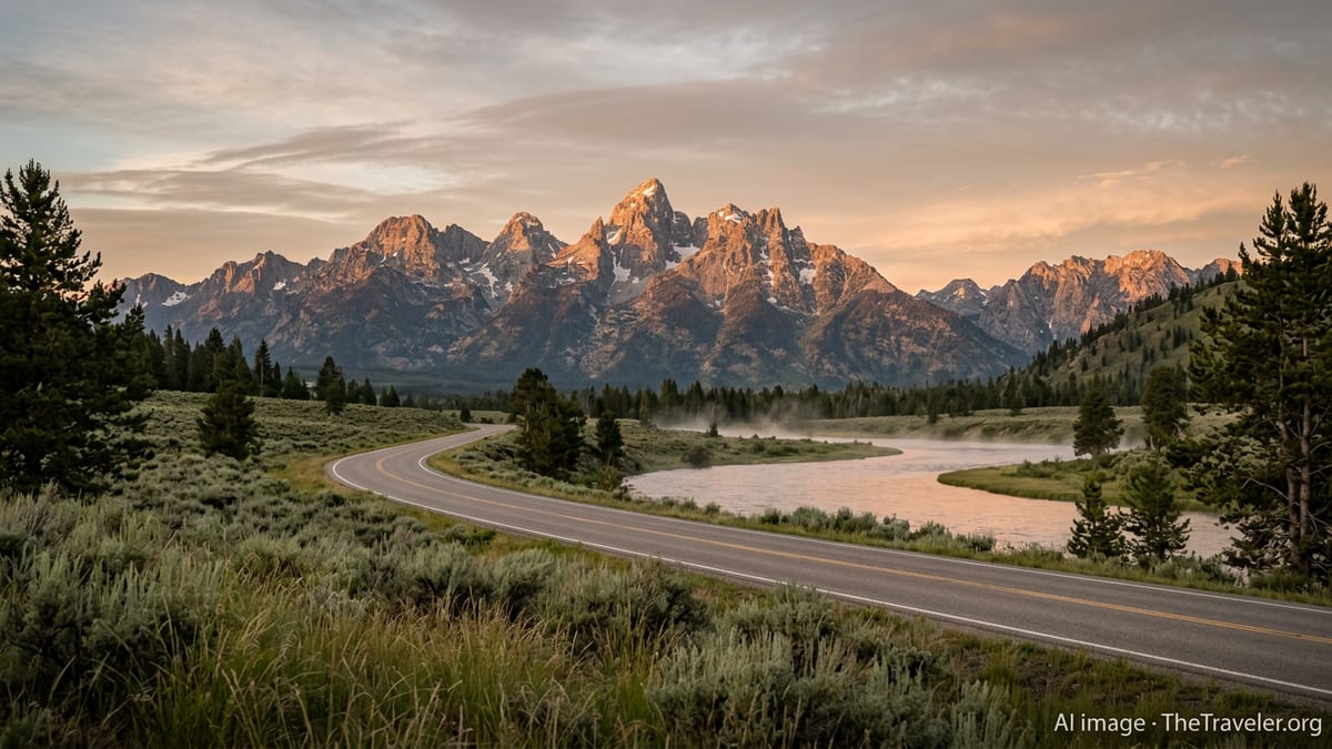
As you descend from the summit toward the Sawtooth Valley, the character of the landscape shifts dramatically. Jagged peaks of the Sawtooth Range rise sharply to the west, while broad grasslands and wetlands extend toward the Salmon River corridor. Pullouts near the base of the valley offer some of the best introductions to the classic Sawtooth skyline, particularly around sunrise and sunset when light grazes the ridgelines.
Stanley, with a small year-round population and a larger seasonal presence, serves as a base camp for exploring the Sawtooth National Recreation Area. Simple motels, cabins, campgrounds, and a few lodges provide a range of lodging options. Book ahead for July and August visits, when trailheads and river outfitters are busiest, and plan for cool nights even in midsummer due to the town’s elevation.
If time and conditions allow, consider a quick orientation walk around town and the nearby Salmon River. The confluence of highway, river, and mountain backdrops makes even short strolls rewarding. As light fades, temperatures usually drop quickly, often creating crisp evening air that pairs well with a short soak at a nearby hot spring.
Day 4: Sawtooth Trails and Stanley Area Hot Springs
Devote your fourth day to the heart of the Sawtooth Mountains. Numerous trailheads lie within a short drive of Stanley, providing access to alpine lakes, meadows, and river valleys. Popular day hikes commonly range from three to eight miles round trip with moderate elevation gain, though more ambitious routes are available for experienced hikers. Choose a trail that aligns with your fitness level and the season’s snow conditions, and start early to avoid afternoon thunderstorms that can build over high ridges in summer.
In the afternoon or evening, shift focus from hiking to soaking. A cluster of hot springs near Stanley provides a variety of experiences, from informal riverside pools to a well-known metal tub perched at river’s edge. Boat Box Hot Spring, also called Elkhorn Hot Spring, sits along the Salmon River a short drive from town. A small tub is fed by a pipe bringing hot water from the spring source, with river water nearby to help moderate temperature. Space is very limited, so many travelers treat this as a quick stop rather than a long soak.
Other hot springs near Stanley, including Sunbeam and additional riverside pools, offer slightly more room to spread out, though they too can feel busy at peak times. Wherever you go, rotate between hot water and cooler air or occasional river dips to avoid overheating. Sitting partly out of the water and drinking plenty of plain water, rather than alcohol, helps reduce dehydration and fatigue.
After sunset, the Sawtooth Valley often delivers exceptional night skies on clear evenings, with limited light pollution. If you are comfortable driving in the dark, consider a short post-dinner soak or a stargazing stop at a pullout away from town. Bring warm layers, as temperatures can fall noticeably once the sun disappears behind the mountains.
Day 5: Sawtooth Scenic Byway to Ketchum and Sun Valley
On Day 5, leave Stanley and head south on Highway 75, designated as the Sawtooth Scenic Byway. The road initially follows the Salmon River before climbing toward Galena Summit, one of the most celebrated viewpoints in central Idaho. From pullouts near the summit, you can look back toward the Sawtooth Range and forward into the Big Wood River valley, taking in a broad panorama of peaks and forest.
The descent from Galena Summit follows the headwaters of the Big Wood River through conifer forest into increasingly open terrain as you approach the resort communities of Ketchum and Sun Valley. This stretch of highway combines mountain scenery with more developed infrastructure, including ski areas, trail networks, and a paved multi-use path that runs along portions of the valley. It provides a contrast to the more remote feel of Stanley and the upper Salmon corridor.
Spend the afternoon exploring Ketchum’s compact downtown, where galleries, outfitters, and restaurants cluster within walking distance. The community has a strong outdoor culture, and local shops can offer up-to-date advice on trail conditions, biking routes, and seasonal events. In summer, short hikes or chairlift rides at nearby ski areas often provide easy access to elevated viewpoints above the valley.
While Ketchum is not a major hot spring hub in the same sense as Lowman or Stanley, the region’s geothermal activity continues along wider central Idaho. Depending on your timing and interests, you may opt for a second night in Stanley and a day hike deeper into the Sawtooth backcountry instead, then continue to Ketchum in the late afternoon. Both options keep you aligned with the overall loop toward Idaho’s waterfalls and southern hot springs.
Day 6: Southern Idaho Waterfalls and Hot Springs
From the Sun Valley area, begin angling south toward some of Idaho’s signature waterfalls and canyon country. One common pattern is to route through south central Idaho to reach the Snake River Plain, where the river has carved a broad canyon punctuated by dramatic falls. Shoshone Falls, near the city of Twin Falls, is often referred to as one of the largest waterfalls in the American West by volume when upstream flows are high, with a broad curtain of water dropping into a deep basalt amphitheater.
Shoshone Falls sits within a city-managed park setting with roads, viewpoints, and seasonal facilities. Water flow varies widely depending on the time of year and upstream irrigation demand. Spring and early summer typically bring stronger runoff and more impressive displays, while late summer and fall can be comparatively modest. Even in lower-flow periods, the canyon setting, rim viewpoints, and nearby walking paths remain worthwhile.
Beyond Shoshone Falls, the Thousand Springs area along the Snake River near Hagerman showcases another face of Idaho’s water landscape. Here, water seeps and cascades from canyon walls in multiple locations, feeding hanging gardens and side channels. Several units of a state park protect different segments, with viewpoints, picnic areas, and in some cases access to boat ramps or trails. Conditions and access points evolve over time, so confirm current details shortly before your trip.
Southern Idaho also hosts additional hot springs, including riverside pools and developed soaking complexes near agricultural towns. Some sites are accessible only by watercraft, while others are reached by short walks from parking areas. If you plan to combine waterfall viewing with another hot spring session on Day 6, keep drive times realistic and factor in time for meals, rest, and potential crowds at more popular stops.
Day 7: Eastern Idaho Detour to Mesa Falls or Return to Boise
If you have the time and interest, Day 7 can include a detour to eastern Idaho to visit Mesa Falls before looping back toward Boise. Upper and Lower Mesa Falls lie on the Henrys Fork of the Snake River, accessed by a forest road known as the Mesa Falls Scenic Byway. Here, the river plunges over a pair of impressive drops framed by basalt cliffs and mixed conifer forest. Upper Mesa Falls in particular is known for its wide curtain and viewing platforms that allow relatively close perspectives without technical hiking.
Depending on your starting point, visiting Mesa Falls adds several hours of driving to your itinerary, so it works best if you are already in eastern Idaho or combining this trip with a broader circuit that includes Idaho Falls or the Yellowstone region. In winter and early spring, snow and ice can affect road access and require extra caution, while summer and early fall generally offer easier driving and walking conditions.
Travelers opting to forgo the eastern detour can instead use Day 7 to return from the Twin Falls area toward Boise. Several routes cross the Snake River Plain, connecting agricultural communities, small canyons, and occasional viewpoints over the river corridor. While this leg is less mountainous than earlier days, it provides a glimpse into the irrigated landscapes and open skies that define much of southern Idaho.
Whichever path you choose, aim for a relaxed final evening. Build in buffer time for unexpected delays, last scenic stops, or one more soak if you pass a hot spring with available space and comfortable conditions. Reflecting on the week’s variety of landscapes, from tight river gorges to sharp alpine peaks and broad volcanic plains, can help you decide which corner of Idaho you might return to for a deeper dive.
Planning Tips, Seasons, and Safety
Central and southern Idaho are very much four-season destinations, but this road trip is usually most straightforward from late June through September, when high passes are typically snow free and most forest service campgrounds and facilities are open. Shoulder seasons in May, early June, and October can offer fewer crowds and cooler temperatures, but snow, ice, or lingering drifts may still affect trailheads, hot spring access paths, and mountain passes.
Summer brings warmer daytime highs, especially in canyon and plain sections, as well as potential afternoon thunderstorms in the high country and the possibility of wildfire smoke affecting air quality and visibility. Start hikes early, carry extra water, and pay attention to local advisories regarding fire restrictions and air conditions. In fall, nights become significantly colder in high valleys like Stanley, and some lodges, restaurants, or tour operators may shift to reduced hours or close for the season.
Water safety is a recurring theme on this itinerary. Rivers can run fast and cold even in midsummer, and rocks in and around waterfalls and hot springs are frequently slick with algae or spray. Avoid wading near the lip of any waterfall, keep a safe distance from unstable canyon edges, and never attempt to swim across a fast-moving current to reach a hot spring pool. Parents should keep children within arm’s reach near water and steep drop-offs.
Finally, remember that cell coverage is patchy or absent in many of the canyons and mountain valleys you will pass through. Download offline maps, carry paper backups, and let someone at home know your general route and timing. A basic roadside emergency kit, extra food and water, warm layers, and a full fuel tank before entering more remote stretches will all add a margin of safety and peace of mind.
The Takeaway
A 7-day Idaho road trip that threads together the Sawtooth Mountains, riverside hot springs, and dramatic waterfalls showcases how varied the state’s landscapes are within a relatively compact area. In a single week, you can move from pine-clad passes to high alpine basins, then down to lava-carved river canyons, while punctuating your days with short hikes and restorative soaks.
This itinerary outlines a balanced route, but its real strength is flexibility. You might spend extra time in the Sawtooths chasing alpine light and cold lakes, linger along the South Fork of the Payette for multiple hot spring sessions, or focus more heavily on the Snake River canyon and its waterfalls. Adjust your overnights, driving days, and side trips to match your interests, comfort with mountain driving, and the realities of season and weather.
Whatever adjustments you make, approach Idaho’s mountains and rivers with patience and respect. Build in margin for changing conditions, treat hot springs and fragile river corridors gently, and prioritize your own safety and that of others. Do that, and this 7-day loop will not only deliver memorable views and photographs, but also the rare sense of immersion that comes from moving slowly through big, still-wild country.
FAQ
Q1. What is the best time of year for this 7-day Idaho road trip?
The most straightforward period is typically late June through September, when high passes, campgrounds, and most trails are snow free and fully accessible.
Q2. Do I need a four-wheel-drive vehicle for the Sawtooth and hot springs areas?
No, the main highways and most access roads in this itinerary are usually passable in a standard car during summer, though higher clearance helps on rougher gravel spurs.
Q3. How many hours per day will I be driving on this route?
Most travel days involve roughly two to four hours of driving, not counting photo stops, short walks, construction delays, or time spent searching for parking at popular sites.
Q4. Are the natural hot springs suitable for children?
Many springs are family friendly, but temperatures, currents, and slippery rocks require close supervision. Always test water first and keep children away from fast-moving rivers.
Q5. Can I visit Shoshone Falls and Mesa Falls on the same trip?
Yes, but combining both often requires additional driving and at least one extra day, especially if you are also focusing on the Sawtooth region in a single week.
Q6. Do I need advance reservations for lodging in places like Stanley and Ketchum?
In peak summer and on holiday weekends, advance reservations are strongly recommended, particularly in smaller mountain towns where accommodations are limited.
Q7. Are dogs allowed on trails and at hot springs?
Leashed dogs are allowed on many national forest trails, but individual hot springs, parks, or lodging providers may restrict pets, so always check current rules before arriving.
Q8. How can I avoid crowds at popular hot springs and viewpoints?
Visit early in the morning or later in the evening, avoid weekends and holidays when possible, and be willing to move on if a small site is already at capacity.
Q9. Is swimming allowed at Idaho’s major waterfalls?
Swimming is generally unsafe and often prohibited near the base or lip of large waterfalls due to powerful currents, cold water, submerged hazards, and restricted access areas.
Q10. What should I pack specifically for this road trip?
Pack layered clothing for variable mountain temperatures, sturdy footwear, water shoes for hot springs, sun protection, offline maps, and extra food and water for remote stretches.