
Encircled by granite ridges and classic Muskoka forest, Lake of Bays offers some of the most atmospheric scenery in Ontario’s cottage country. From iconic lookout towers and island golf greens to thundering waterfalls and quiet village beaches, this lake in northeastern Muskoka rewards travelers who linger and explore its backroads.
Whether you come for a day trip from Huntsville or build an entire holiday around the region, these eight scenic spots around Lake of Bays showcase the area at its most memorable.
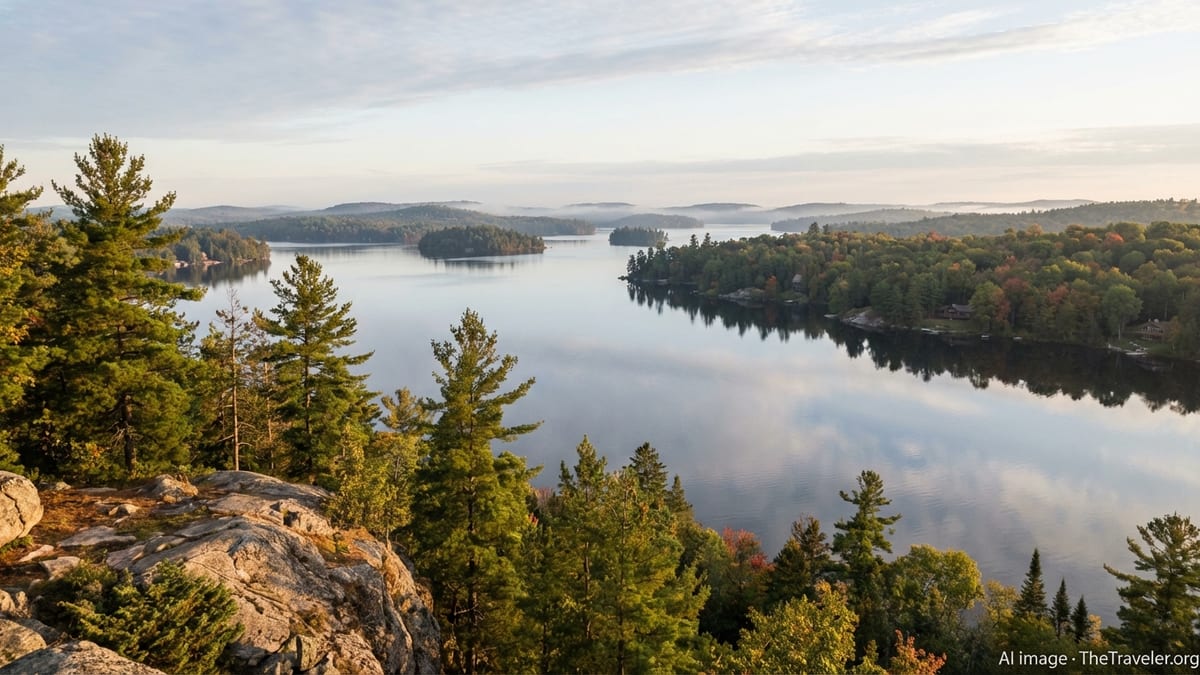
Dorset Scenic Lookout Tower
Rising above the treeline north of the village of Dorset, the Dorset Scenic Lookout Tower is the single most famous viewpoint on Lake of Bays. Built in 1967 on the site of a former forest fire lookout, the steel tower and its surrounding hilltop park deliver a sweeping panorama of blue water, forested islands and the rolling Algonquin Highlands. Even when the tower itself is closed outside the operating season, the access road, trails and high ground in this area remain a reference point for some of the best lake vistas in the region.
Climbing to One of Ontario’s Classic Lake Vistas
The Dorset Scenic Lookout Tower stands about 30 metres high on a hill that rises roughly 142 metres above Lake of Bays, so the combined elevation puts you far above the canopy. Visitors who climb the staircase to the main observation platform are rewarded with a 360-degree view that takes in long arms of Lake of Bays, nearby trading-post villages and the layered ridges that lead toward Algonquin Provincial Park.
On clear summer days you can pick out the tiny wakes of passing boats and the pale cuts of cottage roads threading through the forest. In autumn, the same view turns into a dense patchwork of crimson maples, gold birches and dark-green conifers that draws photographers from across the province. If you prefer to keep your feet closer to the ground, the shorter walk to Peek-a-boo Rock on the same hill offers a broad, less exposed viewpoint over Dorset and the lake.
Planning Your Visit
The tower site is reached via Dorset Scenic Tower Road, just off Highway 35. A small park surrounds the tower, with picnic tables, washrooms, an information kiosk and a short interpretive trail. During the main visiting season there is a per-vehicle parking fee and on peak fall-colour weekends visitors may face queues or be asked to park in the village and hike up via the marked trail from behind the Dorset Heritage Museum.
Because the site is exposed and high above the lake, weather can change quickly and winds feel stronger at the top. Comfortable walking shoes and layered clothing make the climb safer and more enjoyable. Outside the main operating season, always check local notices for access updates and seasonal closures, and remember that any climb is strictly at your own risk.
Ragged Falls and the Oxtongue River
Just northeast of Lake of Bays, the Oxtongue River tumbles through a narrow rock gorge in an impressive series of chutes and ledges known as Ragged Falls. Protected within Oxtongue River–Ragged Falls Provincial Park, this is one of Ontario’s best-known waterfalls and a powerful counterpoint to the calm bays and beaches on the lake below. The area is relatively compact and easy to reach, which makes it an ideal scenic stop on a loop that also includes Dwight or a day trip toward Algonquin Provincial Park.
Experiencing One of Ontario’s Top Waterfalls
From the small parking lot just off Highway 60, a short, well-groomed trail leads through mixed forest to the main overlooks above Ragged Falls. Here the Oxtongue River narrows and surges over a broken rock lip, plunging in foaming torrents between sculpted granite walls. Depending on recent rainfall and snowmelt, the falls can be a thundering brown-and-white torrent in spring or a more defined, emerald-edged cascade in late summer.
Rocky outcrops beside the trail allow for several different vantage points. Upstream, quieter pools and smaller drops hint at the river’s journey from Algonquin’s interior lakes. Downstream, the water powers on toward Oxtongue Lake and eventually Dwight Bay on Lake of Bays. In winter, the scene transforms again as ice formations creep along the rock, leaving open channels of fast-moving water framed by snow-laden branches.
Short Hikes, Paddling Routes and Safety Tips
Oxtongue River–Ragged Falls Provincial Park is set up primarily for day use, with basic facilities such as parking, a pit toilet and signed trails. There is no camping, and visitors are expected to bring their own drinking water and pack out all garbage. The main trail to the falls lookout is short, but roots and rocks can be slippery after rain or in shoulder seasons, so sturdy footwear is recommended.
For a different perspective, paddlers on Oxtongue Lake often follow the river upstream to the base of the falls, keeping to designated no-wake zones and respecting wildlife along the shore. This route reveals quieter stretches of current lined with cedars and spruce, and it is common to spot great blue herons, beavers and other wildlife along the way. Because currents become strong as you approach the base of the falls, always heed local advice and keep a conservative safety margin.
Dwight Beach and the Shores of Dwight Bay
On the western side of Lake of Bays, the small community of Dwight fronts a wide, shallow bay that feels tailor-made for relaxed summer days. Dwight Beach is one of the most family-friendly shorelines on the lake, with an expansive sweep of sand, gentle entry into the water and open views across Dwight Bay toward forested points and distant islands. It serves as a visual introduction to Lake of Bays for many travelers arriving from Huntsville and Highway 60.
A Classic Muskoka Beachfront
Dwight Beach combines natural beauty with easy access. A long arc of pale sand and gravel curves along the bay, backed by grass, mature shade trees and seasonal picnic tables. The lake here remains shallow for some distance, which warms the water earlier in the summer and makes it suitable for children and cautious swimmers. On calm days the mirror-like surface reflects sky and clouds, while evenings often bring soft pastel colours as the sun dips behind the hills.
Looking out from the shoreline, you can see the broader character of Lake of Bays: low granite ridges, scattered cottages tucked into the trees, and the occasional motorboat or canoe passing far offshore. Despite its popularity, the beach retains a relaxed, community feel, especially on weekday mornings and outside peak holiday periods.
Amenity Hub and Gateway to the Lake
The village of Dwight sits just behind the beach, providing practical conveniences that also make this a comfortable scenic stop. Travelers will find small shops, cafés and a well-known local bakery, along with public washrooms and designated parking areas near the waterfront. A short stroll from the sand leads to parks and open spaces where visitors can stretch their legs after time in the car.
Because Dwight lies along the corridor between Muskoka and Algonquin Provincial Park, it works well as either a base or a rest stop. Early risers can enjoy misty, almost deserted views over Dwight Bay before day-trippers arrive, while late-afternoon visitors often catch golden light slanting across the water. Respect posted signage about swimming areas, boat launches and parking, as the waterfront serves both locals and visitors.
Bigwin Island and Its Heritage Shorelines
Occupying a prominent position in the middle of Lake of Bays, Bigwin Island is the lake’s largest island and one of its most storied landscapes. For more than a century, this 222-hectare island has drawn visitors with a combination of natural beauty and resort-life history. Today it is best known for its private golf club and cottages, but the forest-framed shorelines and glimpses of heritage buildings still lend Bigwin Island a romantic, almost timeless quality when seen from the water.
Island Scenery Steeped in History
Bigwin Island’s history includes its role as the site of Bigwin Inn, once promoted as one of North America’s largest and most luxurious summer resorts. Many of the original structures and stone details remain part of the island’s built landscape, now adapted into a clubhouse, dining spaces and other facilities associated with the modern Bigwin Island Golf Club. Against a backdrop of pines, maples and rugged shoreline rock, these heritage features add texture to the island’s silhouette.
The island’s position near the centre of Lake of Bays means that views in all directions are dramatic. From passing boats you see long sweeps of fairway running down toward rocky bays, wooden docks framed by wind-bent white pines and cottages set discreetly among the trees. In autumn, the forest canopy across the island turns into a vivid mosaic of colour, reflected in the open water that surrounds it.
Experiencing Bigwin from the Water
Because Bigwin Island today is home to a private golf club and cottage community, general public access onto the island itself is limited and usually arranged through members, resort partners or special events. For most visitors, the most practical way to appreciate its scenery is from the water. Local marinas and lodges around the lake offer boat rentals, water taxis and guided cruises that pass close to the island’s shore.
Cruising Bigwin’s perimeter highlights the interplay of manicured golf greens and raw Canadian Shield geology. Quiet coves, narrow channels and open reaches around the island make for engaging paddling routes when weather allows. Boaters should always respect private property and wake restrictions, and keep an eye on navigation markers, as the lake contains shoals and rocks that may lie just below the surface.
Oxtongue Rapids and Marsh’s Falls
Downstream from Ragged Falls, the Oxtongue River continues its journey toward Lake of Bays in a series of lesser-known but highly photogenic rapids and small waterfalls. Oxtongue Rapids Park and the nearby Marsh’s Falls area provide more intimate river scenery than the dramatic gorge upstream. Smooth bedrock shelves, swirling currents and overhanging cedars create a setting that feels both wild and accessible, ideal for visitors seeking a quieter stop close to the lake.
River Sculpted Rock at Oxtongue Rapids Park
Oxtongue Rapids Park, situated near the village of Dwight, is a compact conservation area where the river slides over sloping rock in multiple channels. Rather than a single vertical drop, you see a long run of fast water punctuated by eddies and small standing waves. Flat rock benches along the shore make natural viewing platforms and picnic spots, while the sound of rushing water muffles road noise and creates a surprisingly secluded atmosphere.
Short paths wind through mixed forest to different vantage points, some at water level and others slightly elevated. In spring the rapids surge with snowmelt; by late summer the exposed rock shows patterns carved over thousands of years of flow. It is a favourite local spot for photographers and anyone who enjoys lingering beside moving water.
The Tranquil Charm of Marsh’s Falls
A little farther downstream, Marsh’s Falls offers a gentler, more pastoral counterpart to Ragged Falls. Here the river drops in a broader fan over rock ledges, surrounded by tall grasses, shrubs and mature trees. The falls and adjacent lands are protected within a nature reserve that recognizes both their ecological value and their role in the scenic character of the lower Oxtongue.
Access points and viewing areas in the Marsh’s Falls vicinity are limited compared with some of the region’s larger parks, and visitors should always respect signage, private property boundaries and sensitive vegetation. When approached quietly and carefully, this stretch of river reveals an abundance of birdlife and the subtle beauty of a watercourse approaching its mouth on Lake of Bays.
Baysville Waterfront and Bridge Views
At the southern end of Lake of Bays, the village of Baysville combines heritage charm with excellent waterside perspectives of the lake’s narrow, river-like reaches. This is where the Muskoka River flows into Lake of Bays, and the converging channels, low bridges and shoreline parks create a series of human-scaled viewpoints. Baysville’s waterfront is particularly appealing to travelers interested in pairing scenery with local history, as many early resort stories and logging-era tales are tied to this corner of the lake.
Strolling the River Mouth
The heart of Baysville’s scenic appeal lies along the streets and small parks that frame the river mouth. From public wharves and lawned areas near the main bridge, you can look upstream toward the Muskoka River’s wooded banks or downstream where the water broadens into the upper reaches of Lake of Bays. Reflections of boats, dock pilings and clapboard buildings in the calm water give the area a postcard quality, especially in the early morning or evening.
Simple walking routes link the compact core of the village with its waterfront, making it easy to pause for photographs or a bench-side break. Seasonal planters, mature trees and well-kept buildings contribute to a sense of place, while the constant presence of the water reminds you that this was, and remains, a community shaped by its lakes and rivers.
Small-Town Character in Every Season
Because Baysville is a lived-in village rather than a purpose-built resort, it offers year-round glimpses of everyday Muskoka life. In summer, the public docks host pleasure craft and the sounds of visitors heading out for a day on the lake. In autumn, hills around the village turn rich shades of orange and red, framing the bridges and shoreline with colour. Winter can bring scenes of frozen water, snow-dusted roofs and the sight of residents traveling by snowmobile across the lake surface.
Local businesses, inns and seasonal events give Baysville an energy that complements its scenery. Travelers who take the time to wander the streets, visit a café or stop at a small gallery often find that the village’s atmosphere becomes as much a part of their memory as the view from the water’s edge.
Port Cunnington and Northern Lake Vistas
Along the more lightly developed northern shores of Lake of Bays, the Port Cunnington area offers some of the lake’s widest open-water views. Here, peninsulas and islands align in such a way that long corridors of water stretch south toward Bigwin Island and west toward Dwight Bay. Historic resorts and family cottages occupy sheltered bays, while small public docks and marinas provide windows onto the bigger scenery beyond.
Looking Toward the Heart of the Lake
From vantage points around Port Cunnington, Lake of Bays feels expansive and almost oceanic on windy days. Low, tree-covered ridges ring the horizon, but the distance between opposing shores is greater than in many other parts of the lake. When skies are clear, this space fills with light, cloud reflections and the movement of boats crossing between northern cottages and central islands.
In the quieter hours of early morning or late evening, the same scenes become more introspective. Loons call from offshore, mist rises from the water and the silhouettes of islands emerge slowly as the sun climbs. For photographers, these transitional times of day often produce the most evocative images, with subtle colour shifts and delicate reflections on the water’s surface.
Resort Heritage and Lakeside Leisure
Port Cunnington has long been associated with traditional Muskoka resort life, and that heritage remains visible in the region’s architecture and shoreline layout. Steep-roofed buildings, vintage boathouses and broad lawns that sweep toward the water speak to more than a century of summer holiday culture. Many of these properties now operate as modern lodges or rental accommodations, offering guests direct access to swimming, paddling and evening lakeside fires.
Even if you are not staying overnight, a drive along the access roads leading to Port Cunnington can be rewarding for the glimpses they provide: sudden openings in the trees reveal broad reaches of the lake, and occasional public access points or marina areas let you step briefly onto docks to appreciate the full scale of the view. As always, be mindful of private property and follow any posted restrictions on access and parking.
Hidden Coves and Cottage Country Drives
Beyond the named lookouts, parks and villages, a large part of Lake of Bays’ scenic appeal lies in its quieter corners. Narrow side roads loop off the main highways to reach points, inlets and small bays where the pace slows even further. Many of these places are primarily residential cottage communities, but their public roads and occasional boat launches still provide legitimate, respectful vantage points from which to appreciate the lake’s subtler moods.
Scenic Backroads and Shoreline Drives
Roads such as Muskoka District routes leading to Fox Point, South Portage or other small communities often run close enough to the water to deliver framed views between the trees. Rock cuts, marshy inlets and glimpses of distant islands appear and disappear as you drive, especially in the shoulder seasons when foliage is thinner. Pullouts and roadside parks are few, so drivers should resist the temptation to stop where it is unsafe or prohibited, instead seeking out signed viewpoints and parking areas.
These cottage-country drives are particularly rewarding at the bookends of the day. Shortly after sunrise, low light grazes the rocky shoreline and illuminates thin bands of mist hovering above the water. Before sunset, longer shadows and warm tones bring out texture in the granite and tree trunks, and you may catch sight of deer or foxes along the forest edge.
Respectful Exploration and Local Etiquette
Because many of the lake’s side roads end in clusters of private cottages, visitors should keep local etiquette in mind. Use only clearly designated public access points such as municipal docks or boat launches, observe posted speed limits and be considerate of noise, especially in the early morning and evening. When in doubt about whether an area is public or private, err on the side of caution.
Approached with this respect, cottage-country drives reveal a dimension of Lake of Bays that formal attractions cannot. You see simple boathouses leaning over the water, weathered docks lined with canoes and clusters of Adirondack chairs waiting for their owners. Together, these small, authentic scenes complete the visual story begun at the tower, the waterfalls and the village beaches.
The Takeaway
Lake of Bays rewards travelers who venture beyond the highway and take time to absorb its varied landscapes. From the commanding perspective of the Dorset Scenic Lookout Tower to the raw power of Ragged Falls, from the family-friendly sands of Dwight Beach to the quiet grace of Baysville and Port Cunnington, each corner of the lake reveals a different personality. Bigwin Island’s storied shoreline, the sculpted rock of the Oxtongue River and the modest charm of hidden coves fill in the details.
Some of these sights can be experienced in a single day’s circuit, while others invite a slower stay over several days or seasons. Whichever rhythm you choose, the key is to move deliberately, watch the light, listen to the water and respect both the land and the communities that call it home. Do that, and the eight scenic spots around Lake of Bays will feel less like a checklist and more like chapters in your own evolving relationship with this classic Muskoka lake.
FAQ
Q1. When is the best time of year to visit Lake of Bays for scenery?
The most dramatic scenery typically appears in late September and early October, when fall colours peak, but summer brings warm-water swimming and winter offers serene, snow-covered views.
Q2. Is the Dorset Scenic Lookout Tower suitable for visitors with limited mobility?
The hilltop park and nearby viewpoints are accessible by vehicle during the operating season, but the tower itself is reached only by stairs and may not be suitable for those with serious mobility challenges or vertigo.
Q3. Do I need a permit to visit Ragged Falls and the Oxtongue River lookout?
Yes, visitors are generally required to purchase a day-use parking permit at the provincial park lot; once parked, access to the short trail and lookouts is included.
Q4. Are Dwight Beach and other village shorelines open to the public?
Dwight Beach includes designated public areas with signed access, while some other shoreline sections around the lake are private; always follow local signage and respect property boundaries.
Q5. Can I land on Bigwin Island if I am not a member of the golf club?
Bigwin Island is largely private, so casual landings are not encouraged; most visitors enjoy the island scenery from the water on boat tours, rentals or water taxis.
Q6. Is swimming safe near Ragged Falls and Oxtongue Rapids?
Swimming is not recommended close to the main falls or fast rapids because of strong currents and slippery rocks; instead, choose calmer, designated swimming areas on nearby lakes and beaches.
Q7. How much time should I allow to visit Dorset Tower and Ragged Falls in one trip?
Most visitors spend one to two hours at the Dorset Tower area and around an hour at Ragged Falls, making it reasonable to visit both comfortably in a single day.
Q8. Are there boat rentals available around Lake of Bays to explore scenic spots?
Yes, marinas, lodges and outfitters in communities such as Dwight, Baysville and around Port Cunnington typically offer seasonal rentals of motorboats, canoes and kayaks.
Q9. What kind of wildlife might I see around the lake and river areas?
Common sightings include loons, mergansers, great blue herons, beavers and white-tailed deer, with occasional chances to see moose along quieter stretches of the Oxtongue River.
Q10. Are the scenic roads around Lake of Bays safe to drive in winter?
Main routes are maintained year-round, but conditions can be icy or snow-covered; winter visitors should check forecasts, carry appropriate tires and allow extra time on narrower cottage roads.