
Encircling the world’s largest freshwater lake by surface area, the Lake Superior region stretches across Minnesota, Wisconsin, Michigan, and Ontario, offering a sweep of cliffs, islands, beaches, and boreal forest that feels almost oceanic in scale. Whether you come for hiking, scenic drives, waterfalls, or lighthouses, this inland sea rewards unhurried exploration and a healthy respect for its notoriously changeable weather. The following ten experiences highlight some of the most compelling ways to discover Lake Superior, from classic road trips to less-traveled trails overlooking the endless blue horizon.
Drive Minnesota’s North Shore on Highway 61
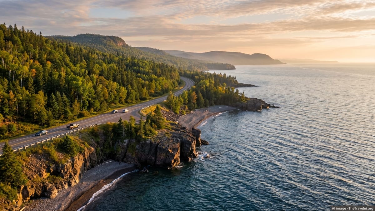
The North Shore of Lake Superior in Minnesota is one of North America’s classic scenic drives, tracing rocky shoreline and forested ridges from Duluth to the Canadian border. Much of the route follows Highway 61, with frequent pullouts and short walks that bring you directly to wave-washed basalt, pebble beaches, and overlooks where the lake fills the entire horizon. Several Minnesota state parks are strung along this corridor, making it easy to pair leisurely driving with frequent hikes and photo stops.
The drive is especially known for waterfalls and dramatic headlands. Gooseberry Falls State Park offers easy access to tiered waterfalls on the Gooseberry River just inland from the lake, while Split Rock Lighthouse State Park provides one of the region’s signature views: a historic light station perched high on a cliff, reached by short trails and stairways. Farther northeast, Tettegouche State Park, Temperance River State Park, and Cascade River State Park showcase deep river gorges, cascades, and sweeping lake vistas from rocky points like Palisade Head and Shovel Point, where cliffs rise straight from the water’s edge.
Allow at least a full day to drive from Duluth to Grand Marais with unhurried stops, and longer if you plan to hike in multiple parks. Minnesota state parks require a vehicle permit, which can be purchased at park entrances and helps support maintenance of trails, facilities, and natural resources. Driving conditions are generally straightforward, but you should be prepared for fog, rain, or sudden changes in wind off the lake, especially in shoulder seasons when weather can shift quickly.
In summer, the North Shore bustles with road trippers, cyclists, and campers, while autumn transforms the ridges above the lake into a patchwork of red and gold. Winter driving can be more challenging, yet the payoff for those properly equipped is a landscape of frozen waterfalls, ice-framed shorelines, and quiet parks where snowshoeing and cross-country skiing replace warm-weather hiking.
Walk Lakeside on the Gitchi-Gami State Trail
For a slower, more immersive way to experience Minnesota’s North Shore, the Gitchi-Gami State Trail offers paved sections suitable for walking, biking, and in-line skating. Planned as an 88 mile route between Two Harbors and Grand Marais, the trail is currently built in several noncontiguous segments but already links some of the region’s most photogenic stretches of shoreline. Portions near Gooseberry Falls and Split Rock Lighthouse are particularly popular, giving users continuous views of Lake Superior along gently rolling terrain.
The trail often parallels Highway 61 but diverges where possible for better scenery and safety, traversing state park land and public right of way. You can expect long sightlines to the open lake, occasional glimpses of ships on the horizon, and a front row view of rocky coves and ledges where waves crash in windy weather. Benches and wayside areas appear at intervals, inviting you to rest and watch the water or enjoy a picnic away from vehicle traffic.
Because segments are disconnected, it pays to research which portion best fits your day, fitness level, and interests. Short family-friendly outings might focus on the Gooseberry Falls to Split Rock Lighthouse section, where interpretive signs explain the region’s geology and cultural history. Cyclists and skaters can cover more ground by linking multiple sections, but should remain alert for transitions, road crossings, and changing pavement conditions.
Spring through autumn are prime seasons, although shoulder periods can be delightful if you dress for wind and variable temperatures. In high summer, you will want sun protection, water, and insect repellent, especially on forested stretches set back from the lake. In all seasons, remember that Lake Superior’s weather can cool the air dramatically compared to inland areas, so layering is wise even on seemingly warm days.
Explore Pictured Rocks National Lakeshore by Trail and Water
On the south shore in Michigan’s Upper Peninsula, Pictured Rocks National Lakeshore offers one of the most distinctive landscapes on Lake Superior. Multicolored sandstone cliffs, shaped by centuries of wind, waves, and freezing spray, rise above turquoise water in a palette of ochre, green, and rust. The lakeshore also includes secluded beaches, sand dunes, and inland forests dotted with waterfalls and lakes, making it an all-season destination for hikers and paddlers.
Trails near Munising and Grand Marais provide multiple vantage points on the cliffs and shoreline. Popular day hikes include the paths to Miners Castle, Chapel Rock, and Grand Portal Point, where cliff-top overlooks reveal sweeping views of the lake and the sculpted rock formations below. Inland, routes to waterfalls such as Miners Falls, Munising Falls, and Sable Falls showcase smaller scale canyons, mossy ravines, and dense hardwood forest that turns vivid in autumn.
On the water, sightseeing cruises and guided boat tours from the Munising area are the most accessible way to appreciate the full extent of the cliffs, especially for first-time visitors. Some operators also offer glass-bottom tours that combine views of the painted rock walls with glimpses of historic shipwrecks in the clear water below. For experienced paddlers prepared for cold water, changing winds, and potential surf, sea kayak tours provide a close-up perspective on caves, arches, and coves that is unmatched from land.
Conditions around Pictured Rocks can change rapidly, so planning around marine forecasts, trail closures, and seasonal services is important. The park’s roads and visitor centers operate on varying schedules, and winter brings opportunities for snowshoeing and cross-country skiing, along with the need for careful navigation on icy roads and trails. Whenever you visit, treating the lakeshore as a wilderness destination, not a resort area, will help you prepare adequately for its remoteness and power.
Follow Michigan’s Upper Peninsula Scenic Shoreline Drives
Beyond Pictured Rocks, the broader Upper Peninsula of Michigan offers a network of scenic roads that skirt Lake Superior’s coves, sand beaches, and rocky headlands. Routes such as M 28 and M 26 give drivers frequent glimpses of the lake, with opportunities to pull off at roadside parks, sandy stretches, and small harbors that still feel closely tied to their maritime heritage. Many travelers combine these drives into segments of the larger Lake Superior Circle Tour, a multi day journey around the entire lake.
Along M 28 between Munising and Marquette, travelers encounter long, lightly developed strands of sand where dunes meet cold, clear water. Roadside parks and day use areas provide restrooms, picnic tables, and short trails to the shore, although facilities may be seasonally limited and subject to temporary closures for maintenance or upgrades. Between L’Anse and Ontonagon, U.S. 41 and M 38 connect bays, inlets, and viewpoints that look northward toward open water and distant points of land.
Farther west in the Keweenaw Peninsula, State Route 26 and Brockway Mountain Drive are standouts for scenery. Portions of M 26 run very close to the water’s edge between Eagle River and Copper Harbor, with frequent pullouts where you can step out onto cobble beaches and low cliffs. Brockway Mountain Drive, a steep side route above Copper Harbor, climbs to an elevated ridge where panoramic overlooks reveal forest, inland lakes, and Lake Superior stretching to the horizon. The road is typically closed to vehicles in winter and can be narrow and rough in places, so it rewards cautious, unhurried driving.
Because services can be sparse outside of the region’s main towns, it is wise to begin each day’s drive with a full tank of fuel and essential supplies. Cellular coverage can be patchy, particularly in forested stretches and near cliffs, so offline maps and paper guides remain useful. In return, you gain a driving experience that still feels wild and lightly traveled, especially early and late in the day when traffic is minimal and the lake’s changing light becomes the main event.
Hike Ontario’s Sleeping Giant Provincial Park
On the north shore of Lake Superior near Thunder Bay, Sleeping Giant Provincial Park protects the Sibley Peninsula, a distinctive mesa shaped formation that, from a distance, resembles a reclining figure. The park has more than 100 kilometers of hiking trails traversing boreal forest, inland lakes, and cliff edges that rank among Ontario’s highest. For hikers seeking big lake views and a sense of isolated wildness, this is one of the premier destinations on the Superior shoreline.
Signature routes include the Top of the Giant Trail, a challenging outing that gains substantial elevation to reach the plateau above the cliffs. From the main viewpoints, hikers can look down hundreds of meters to the lake and across to islands and peninsulas that dot the horizon. Shorter options such as the Sea Lion Trail lead to distinctive rock formations along the shoreline, while nature trails like Joe Creek, Sibley Creek, and Thunder Bay Bogs provide accessible introductions to local geology, wetlands, and forest ecology.
Sleeping Giant also offers a mix of frontcountry and backcountry camping, with Marie Louise Lake Campground providing vehicle accessible sites and rustic cabins, and remote campsites scattered along longer trails. Water based activities on Marie Louise Lake, including paddling and swimming in calm conditions, complement the more exposed experiences along the Lake Superior shoreline, where waves, cold water, and wind demand added caution.
The park operates seasonally for many services, with a defined summer camping period and winter operations that support activities like snowshoeing and cross-country skiing. Because the park sits directly on Lake Superior, temperatures can be significantly cooler than inland Thunder Bay, and fog or wind may arrive quickly even on otherwise stable weather days. Checking current advisories, trail conditions, and any special regulations before arrival helps ensure a safe and rewarding visit.
Road Trip Through Lake Superior Provincial Park
Further east along Ontario’s coastline, Lake Superior Provincial Park lies between Sault Ste. Marie and Wawa, presenting one of the most continuous stretches of undeveloped shoreline accessible by highway. The Trans Canada Highway passes directly through the park, but short side roads and trailheads lead to secluded cobble beaches, river mouths, and cliff top lookouts that feel far removed from the pavement. For many travelers, this section is a favorite part of the Lake Superior Circle Tour, thanks to its mix of easy roadside stops and more demanding hikes.
Hiking routes vary from short walks to multi day backcountry treks. Well known trails include those to the Agawa Rock pictographs, where Indigenous rock paintings decorate a cliff face directly above the water, and longer routes into the park’s interior lakes and highlands. The shoreline itself alternates between sweeping sand beaches and rugged rocky sections, so you can tailor each stop to your comfort level and the day’s conditions. In calm weather, the water appears startlingly clear and blue, while storms reveal the lake’s more intimidating personality.
The park offers a variety of campgrounds and backcountry sites, along with day use areas that make it feasible to explore even if you are simply passing through in a single day. As with much of the Lake Superior coast, water temperatures remain cold even in midsummer, and the combination of waves, currents, and submerged rocks means swimming should be approached with caution. At viewpoints and cliff top lookouts, it is important to stay behind barriers and give cliff edges a wide berth, especially when surfaces are wet or icy.
Services within the park are intentionally limited to preserve its wild character, so you should plan ahead for fuel, food, and any specialized gear. A flexible schedule is also helpful, as fog, rain, or strong winds can obscure views or make certain shoreline destinations unsafe. When the weather cooperates, however, few places on the lake offer such a concentrated sense of remoteness along a major highway.
Discover Wisconsin’s Apostle Islands from Shore and Sea
On the lake’s southwest corner, Wisconsin’s Apostle Islands region combines charming harbor towns with a protected archipelago known for sandstone cliffs, sea caves, and historic lighthouses. Much of the area falls within Apostle Islands National Lakeshore, where islands are accessible primarily by boat and offer a network of hiking trails, beaches, and backcountry campsites. From the mainland communities, visitors can book sightseeing cruises, shuttles to specific islands, or guided kayak tours that explore caves and arches when lake conditions allow.
On land, the Bayfield Peninsula provides its own scenic drives, orchards, and shoreline walks with views across to the islands. Short trails near Meyers Beach lead to forested clifftops where you can look down on the mainland sea caves that paddlers explore beneath. In winter, if conditions align and the lake ice becomes thick and stable enough, ice formations around the caves occasionally attract visitors on foot, although this is unpredictable and subject to strict safety assessments and closures.
Island hiking experiences vary widely. Some islands have maintained trails that loop through second growth forest to viewpoints, beaches, and lighthouse sites, while others feel more rugged and undeveloped. Overnight camping on the islands requires permits and advance planning, particularly in peak summer when demand is highest. Throughout the archipelago, you are reminded that this is a true inland sea: fog, wind, and waves can disrupt plans with little warning, and water remains cold even during heat waves on shore.
Because access to many of the Apostle Islands depends on boat schedules, weather, and lake conditions, building flexibility into your itinerary is essential. Having backup activities on the mainland, such as visiting local museums, orchards, and galleries or driving the peninsula’s back roads, ensures you can still make the most of your time if open water excursions are delayed or canceled.
Stroll Urban Waterfronts in Duluth, Thunder Bay, and Marquette
While much of Lake Superior’s appeal lies in its wildness, the lake is also framed by historic port cities that offer accessible waterfront walks, cultural experiences, and comfortable bases for day trips. In Duluth, Minnesota, the harborfront and canal district provide close up views of ore ships passing under an iconic lift bridge, backed by hillsides that rise steeply from the lakeshore. Paved paths, parks, and scenic drives like Skyline Parkway give visitors a sense of the lake’s scale without having to venture far from hotels and restaurants.
Across the border in Thunder Bay, Ontario, the revitalized waterfront presents open views toward the Sleeping Giant and the open lake, along with public art, green space, and seasonal events. It serves as both a recreational area for residents and a gateway for travelers heading to or from the Sibley Peninsula. Interpretive displays, museums, and cultural centers in the city provide context about regional history, including Indigenous communities, fur trade routes, and the evolution of Great Lakes shipping.
On the Michigan side, Marquette combines a lively university town atmosphere with extensive lakefront paths and parks. Old ore docks, lighthouses, and preserved industrial structures reflect the city’s role in mining and shipping, while nearby hills and trail systems make it easy to move from downtown streets to forested overlooks in a short drive. For travelers circling the lake, these cities offer opportunities to rest, resupply, and learn about the human stories tied to Lake Superior, balancing the wilderness focus of many smaller communities.
Using these hub cities as bases also allows for more flexible responses to Lake Superior’s unpredictable weather. When fog, high winds, or rain limit visibility on exposed cliffs or boat tours, you can shift to indoor attractions, neighborhood walks, and local dining while waiting for conditions to improve. Each city has its own character, but all three share a close, daily relationship with the lake that shapes their identity and rhythm.
The Takeaway
Travel around Lake Superior is as much about respecting a powerful natural system as it is about checking marquee sights off a list. The hikes, scenic drives, and boat trips described here showcase a range of experiences, from paved shoreline paths and urban promenades to remote cliffs where you can watch weather roll in across miles of open water. What unites them is a sense that this inland sea operates on its own terms, unconcerned with visitor schedules or expectations.
By planning ahead, remaining flexible, and approaching the lake with humility, you can safely enjoy some of the most dramatic freshwater scenery in the world. Layering clothing for sudden temperature shifts, building extra time into driving days, and paying close attention to local advisories all contribute to a smoother journey. In return, Lake Superior offers moments that linger long after you leave: the low thunder of waves against stone, the sudden appearance of a freighter on the horizon, or the first glimpse of cliffs glowing in late afternoon light.
Whether you undertake a full Lake Superior Circle Tour or focus on one segment, from Minnesota’s North Shore to Ontario’s remote parks, the experiences highlighted here provide a framework for trip planning and inspiration for future returns. Many travelers find that one visit simply sparks a desire to see the lake in different seasons, from autumn color to the quiet white expanse of winter. However you choose to explore, Lake Superior rewards patience, curiosity, and a willingness to slow down and let its immense presence set the pace.
FAQ
Q1. When is the best time of year to visit Lake Superior for hiking and scenic drives?
The most popular months are June through October, when roads and trails are generally clear, services are widely available, and daylight is long. Summer offers lush greenery and comfortable temperatures along the shore, while September and early October usually bring vibrant fall color on the ridges. Winter and early spring can be rewarding for those prepared for snow and ice, but require extra planning and flexibility.
Q2. Is it realistic to drive the entire Lake Superior Circle Tour in one trip?
Many travelers complete the Circle Tour in about a week, but that pace allows only brief stops at a selection of highlights. If you want to hike, take boat tours, and explore multiple parks in depth, ten days to two weeks is more comfortable. Some visitors choose to divide the circuit into segments over multiple trips, focusing on one shore at a time.
Q3. How cold is the water in Lake Superior during summer?
Even in mid summer, surface temperatures in most nearshore areas remain quite cold compared to many inland lakes. On some shallow, protected beaches the water may feel relatively mild on calm, sunny days, but sudden changes in wind can rapidly bring colder water to the surface. Anyone entering the lake should be prepared for brisk conditions and limit time in the water, especially far from shore.
Q4. Do I need special permits to hike in parks around Lake Superior?
Most day hikes in state, provincial, and national parks around Lake Superior require either a vehicle entry permit, a day use fee, or both. Backcountry camping typically involves additional reservations and permits, sometimes with quotas in high demand areas. Requirements vary by jurisdiction, so checking each park’s current rules before your trip is important to avoid surprises.
Q5. How challenging are the hiking trails along Lake Superior’s cliffs?
Trail difficulty ranges from short, paved or well graded paths suitable for most visitors to strenuous routes involving significant elevation gain, rocky footing, and exposure near cliff edges. Well known hikes such as the Top of the Giant in Ontario or extended sections of Pictured Rocks’ trail system are demanding and best suited to hikers with good fitness, sturdy footwear, and experience on rugged terrain. When in doubt, start with shorter walks and build up as you gauge conditions and your comfort level.
Q6. What safety considerations are unique to Lake Superior compared with other lakes?
Lake Superior’s size, cold water, and rapid weather shifts create conditions more akin to an inland sea than a typical recreation lake. Waves can build quickly, fog can reduce visibility with little warning, and nearshore currents and submerged rocks pose hazards to swimmers and boaters. Staying informed about weather and marine forecasts, using proper safety gear, and being conservative about paddling or swimming decisions are all prudent steps.
Q7. Are scenic roads around Lake Superior open year round?
Major highways are maintained year round, although winter travel can involve snow, ice, and occasional closures or delays. Some secondary scenic routes, such as Brockway Mountain Drive in Michigan’s Keweenaw Peninsula, close to regular vehicle traffic in winter and may be used instead for snowmobiling or other seasonal activities. Before planning a shoulder season visit that depends on a specific road, verify its typical operating schedule and any recent advisories.
Q8. Can I rely on mobile phone service when hiking or driving near Lake Superior?
Coverage around Lake Superior is improving but remains inconsistent, especially in remote parks, forested interiors, and cliff lined sections of shore. You should not assume a constant signal for navigation or emergencies. Downloading offline maps, carrying paper backups, and letting someone know your plans are sensible precautions, particularly before longer hikes or drives through sparsely populated areas.
Q9. What kind of clothing and gear should I pack for a multi day trip?
Layers are essential, as temperatures can shift quickly between sunny inland areas and the cooler lakeshore. A waterproof shell, warm mid layer, and hat and gloves are useful even in summer, especially on boats or exposed headlands. Sturdy footwear, sun protection, insect repellent, and a small first aid kit round out a basic kit, with additional specialized gear such as trekking poles or dry bags as needed for your chosen activities.
Q10. Is it possible to visit Lake Superior without a car?
Limited bus services, airport shuttles, and seasonal tour operators connect some communities and parks, but most of Lake Superior’s trailheads and viewpoints are easiest to reach by private vehicle. Travelers without a car can still enjoy urban waterfronts in cities such as Duluth, Thunder Bay, and Marquette, and may be able to join guided excursions or day trips from these hubs. However, those seeking maximum flexibility and access to remote areas will find a car or camper van much more practical.