
Few road trips capture the raw beauty of Lake Superior, the legacy of copper mining, and the slow rhythm of small northern towns quite like a loop around Michigan’s Keweenaw Peninsula. Starting in the college town of Houghton, this itinerary traces US 41 and M-26 to Copper Harbor and back along the peninsula’s shorelines, connecting panoramic overlooks, ghostly mine ruins, quiet beaches, and forested curves that feel made for lingering drives.
Understanding the Keweenaw Peninsula Loop
The classic Keweenaw loop begins in Houghton, crosses the Portage Lake Lift Bridge into Hancock, then follows US 41 north through Calumet toward Copper Harbor. From Copper Harbor, many travelers add the Brockway Mountain Drive spur before returning west along the shore-hugging M-26 through Eagle Harbor and Eagle River, reconnecting with US 41 or continuing on M-26 back toward Houghton. The result is a satisfying circuit that showcases both the peninsula’s interior history and its dramatic Lake Superior coastlines.
This loop is easily done in a long day of driving with short stops, but it is far more rewarding when stretched over two or three days. That slower pace allows time to tour historic mines, walk beachside trails, linger over meals in small-town cafes, and catch at least one Lake Superior sunset. The drive itself is not especially long by distance, yet the narrow roads, frequent pullouts, and frequent photo stops tend to slow travel far more than most visitors expect.
Seasonality matters here. Lake-effect snow can bury the Keweenaw, and key scenic byways such as Brockway Mountain Drive typically close to regular vehicles in winter and early spring while remaining open to snowmobiles and winter recreation. Shoulder seasons bring quieter roads and cooler temperatures, while summer and early autumn offer the best chances for clear lake views, accessible hiking trails, and open attractions along the route.
Road conditions can change quickly in this northern climate, so it is wise to check local forecasts and any travel advisories before setting out. Even in ideal weather, travelers should expect slower speeds along portions of M-26 and Brockway Mountain Drive, where curves, hills, and narrow shoulders reward careful, unhurried driving and frequent breaks at signed scenic turnouts.
Launching From Houghton and Hancock
Houghton is both a natural and practical starting point for the Keweenaw loop. It has a compact downtown with hotels, eateries, and access to the Portage Waterway, plus the presence of Michigan Technological University gives the town a youthful energy that contrasts with the quieter communities farther north. Before driving on, many visitors stroll the waterfront, stock up on groceries or picnic supplies, and visit small museums or galleries that hint at the region’s copper-mining past.
The Portage Lake Lift Bridge linking Houghton and Hancock is a landmark in its own right. This towering double-deck vertical-lift bridge carries US 41 and M-26 over the canal and serves as the only road connection between the southern Keweenaw and the section locals often call Copper Island. Crossing it is a symbolic threshold: once on the Hancock side, you are fully committed to the peninsula and its network of forested roads.
Hancock climbs a hill directly above the canal, its main street lined with brick buildings, cafes, and reminders of the Finnish immigrants who helped build this region. A short detour up Quincy Hill brings you to the Quincy Mine complex, where year-round tours explore underground levels and the towering No. 2 Shaft-Rockhouse that overlooks the waterway. Stepping into the mine offers context for the ruins you will see elsewhere on the loop and is one of the best introductions to the Keweenaw’s industrial heritage.
Leaving Hancock, US 41 climbs out of town and begins tracing the spine of the peninsula past forest, wetlands, and small communities. This stretch is less about dramatic scenery than settling into the rhythm of the drive. The highway passes near the local airport, small lakes, and remnants of historic townsites before reaching the more concentrated mining-era architecture of Calumet and Laurium, natural places to pause before continuing north.
Calumet, Laurium and the Heart of Copper Country
Calumet, once a booming mining hub, now feels like a time capsule of late nineteenth and early twentieth century architecture. Its brick commercial blocks, churches, and civic buildings form the core of Calumet’s historic district, which is part of Keweenaw National Historical Park. Walking the streets here helps turn vague notions of “copper country” into something tangible: a place where tens of thousands of people once lived and worked in an isolated northern landscape.
Travelers with an interest in history can spend several hours in and around Calumet visiting interpretive centers, restored buildings, and small museums that tell the story of labor, immigration, and industrial risk. Even a shorter stop to stroll main streets, step into a café, or photograph ornate facades provides a sense of how substantial these communities once were. Laurium, just to the south, features large homes that reflect the wealth generated by copper, and a slow drive through its residential streets adds another layer to the story.
From Calumet, US 41 and M-26 overlap briefly as they continue north through forest and scattered settlements. The traffic typically thins beyond this point, and the road feels more like a corridor into a wilder peninsula. Soon the highways diverge at the small community of Phoenix. Here you make a decision that shapes the feel of your loop: continue on US 41 toward Delaware and Copper Harbor through the interior, or follow M-26 as it swings toward Lake Superior and some of the peninsula’s most photographed shoreline.
Many travelers choose a combination, driving the interior US 41 route north to Copper Harbor and then looping back along the coast on M-26. This approach delivers a sense of progression from the built environment of the mining towns to increasingly remote forest and then out to the open water of Lake Superior, all within a single day’s worth of unhurried driving.
US 41 to Copper Harbor: Forest Corridors and Historic Sites
Continuing on US 41 from Phoenix, the highway narrows into a classic Northwoods corridor. In summer, trees arch over the road in places to form a leafy tunnel, while in autumn the canopy glows with color. The sense of remoteness increases even though you are still on a major state trunkline, and traffic often falls away to a few cars and the occasional service truck.
Along this stretch are remnants of the region’s deep mining history, including the Delaware Mine site south of Copper Harbor. In season, guided and self-guided tours descend into one of the peninsula’s older copper mines, offering a more intimate experience than some of the larger heritage sites. Even without a tour, interpretive signs and preserved structures give an evocative glimpse of nineteenth-century industry set against today’s quiet forest.
As US 41 nears Copper Harbor, the forest occasionally opens to reveal glimpses of inland lakes and rocky outcrops. Roadside markers and small pullouts provide short walking opportunities and viewpoints. The approach to town feels gradual, with the highway eventually entering Copper Harbor along a modest main street lined with lodgings, eateries, outfitters, and seasonal shops that cater to both road trippers and hikers, bikers, and paddlers.
Beyond the village, US 41 continues a short distance toward Fort Wilkins Historic State Park and the narrow eastern tip of the peninsula. The highway’s official terminus lies just past the park entrance, marked by signage that notes the long distance to the opposite end of US 41 in Florida. Here, the sense of having reached the literal end of the road is strong, and many travelers park to walk, visit the restored nineteenth-century military post, or simply stand along the shore watching Lake Superior’s waves roll in from the open horizon.
Copper Harbor, Brockway Mountain and the North Shore
Copper Harbor is a compact base with a surprising range of outdoor opportunities for such a small community. In summer and early fall, nearby trail systems draw mountain bikers and hikers, while boat tours and paddling trips explore the sheltered harbor and open lake. Lodging options range from simple motels and cabins to small resorts and campgrounds. Dining can be limited outside peak season, so it is wise to check hours ahead and keep some basic provisions on hand.
One of the signature experiences above Copper Harbor is Brockway Mountain Drive, an approximately nine-mile ridge-top road linking the heights above town with M-26 to the west. In snow-free seasons, this byway offers expansive views over Lake Superior, the surrounding forest, and the small grid of Copper Harbor far below. Multiple pullouts along the route allow travelers to step out, photograph the landscape, and watch passing weather systems roll in across the lake.
Because Brockway Mountain Drive climbs steeply, features hairpin turns, and is unplowed in winter, it is best tackled in dry conditions and at a leisurely pace. Low gears and careful driving are recommended, especially in vehicles towing trailers or with limited braking power on steep grades. During winter, the closed road becomes a corridor for snowmobiles and human-powered recreation, adding to the region’s appeal for those comfortable traveling in deep snow and subfreezing temperatures.
Back in Copper Harbor, a short drive east brings you to the shoreline around Fort Wilkins and Lake Fanny Hooe, where campgrounds, day-use areas, and a historic bridge over a small creek frame quieter scenes than the dramatic vistas atop Brockway. Whether you spend an afternoon or several days based here, Copper Harbor forms the natural turning point of the loop, after which the route bends southwest along M-26 to showcase the peninsula’s most striking coastal scenery.
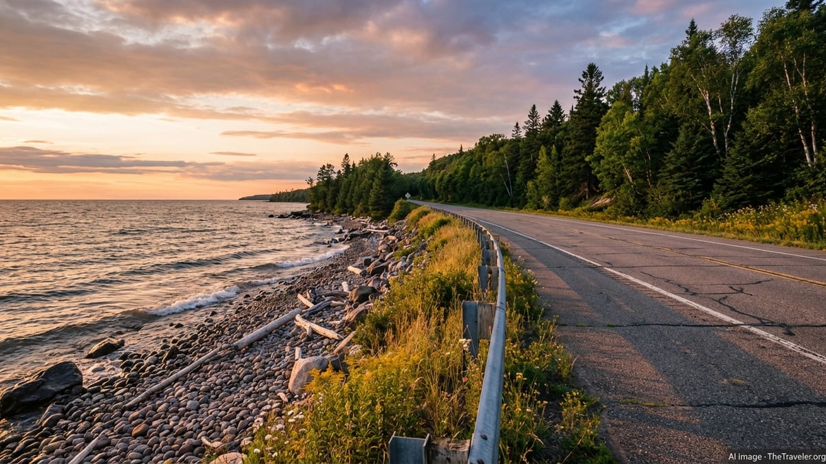
Scenic M-26: Eagle Harbor, Eagle River and the Lake Superior Coast
Heading west from Copper Harbor, M-26 closely follows the north shore of the Keweenaw, carving a route between rocky bluffs and Lake Superior’s restless water. This is the portion of the loop that often lingers in memory: a series of small coves, sandy or cobbled beaches, lighthouses, and wayside parks where the lake feels immediately present. Pullouts are frequent, and it is worth taking advantage of them rather than trying to drive this stretch in a single push.
Eagle Harbor is one of the first substantial stops along this route, a quiet harbor community tucked into a natural bay. Its historic lighthouse and breakwater provide focal points for photographs and short walks, and a small public beach invites picnics and quick swims in warm weather. A grid of local streets climbs the hillside above the harbor, lending a lived-in feel that balances the area’s role as a seasonal vacation enclave.
Farther west, Eagle River sits at the mouth of a river that spills into Lake Superior beside a small falls and a historic bridge. The village has a scattering of shoreline cottages, lodging, and dining, and the nearby beach and roadside parks offer easy access for watching sunsets or wandering the shoreline. Between Eagle Harbor and Eagle River, M-26 threads past protected coves, rock shelves, and viewpoints where Lake Superior’s moods are fully on display, from glassy calm to wind-whipped whitecaps.
Continuing toward the interior, M-26 eventually swings away from the open lake and back into forests and small communities on its return toward Calumet, Lake Linden, and, ultimately, the Houghton area. Travelers who prefer to stay close to the shoreline for as long as possible can add short detours along local roads to reaches of sand and cobble, small wetlands, and understated wayside parks that often see fewer visitors than the better-known harbor towns.
Planning Your Keweenaw Peninsula Loop Itinerary
How long you allocate for the Keweenaw loop depends on your travel style, tolerance for long driving days, and interest in lingering at historic sites or on trails. A dedicated, long summer day could include a morning departure from Houghton, key stops in Hancock and Calumet, an afternoon in Copper Harbor and on Brockway Mountain, and a sunset drive along M-26 back toward Houghton. However, that pace leaves little margin for weather, photography, longer hikes, or mine tours.
Many travelers find that two full days and one or two overnights create a more relaxed experience. One common plan includes a first day exploring Houghton and Hancock, touring Quincy Mine, and continuing to Calumet for a walk through its historic district before arriving in Copper Harbor for the night. The second day can then be dedicated to Brockway Mountain, shoreline exploration around Copper Harbor, and an unhurried M-26 return, with time for stops in Eagle Harbor, Eagle River, and smaller roadside parks.
Accommodation options fill quickly during peak summer and fall color season, especially in Copper Harbor and the harbor towns along M-26. Booking ahead is strongly recommended for weekend and holiday travel. Camping is available at state park and private campgrounds around the peninsula, and some travelers combine camping nights in the north with hotel stays in Houghton or Hancock at the start or end of the loop.
Regardless of timing, it is wise to build flexibility into your plan. Lake Superior’s weather can shift rapidly, with fog, sudden rain, or gusty winds changing visibility and driving comfort. Having an extra hour or two in the schedule allows you to wait out a passing shower at a café, linger over an unexpectedly good viewpoint, or take a spur road that catches your attention without worrying about arriving late at your evening stop.
Practical Tips for Driving the Keweenaw Loop
The Keweenaw’s roads are paved but can be narrow, winding, and occasionally rough, particularly on side roads and older segments that see harsh freeze-thaw cycles. Driving at moderate speeds and staying alert for wildlife, especially deer, is important, particularly at dawn and dusk. Cell coverage can be patchy in the more remote sections, so offline maps or printed directions are useful backups.
Fuel is available in the major communities, but stations become sparse between Calumet and Copper Harbor and along parts of M-26. Topping off your tank in Houghton, Hancock, or Calumet before continuing north reduces the risk of range anxiety, especially if you plan detours to small trailheads or remote beaches. Electric vehicle charging infrastructure is evolving but still limited, so EV drivers should research locations and plan carefully.
Packing layers and weather-resistant clothing is essential even in midsummer, as Lake Superior can produce cool breezes and quick temperature swings. Footwear suitable for wet rock and sand will make spontaneous beach stops, lighthouse visits, and short hikes more comfortable. Insect activity peaks in late spring and early summer, so repellent and lightweight long-sleeved clothing are prudent if you plan to spend much time outside the car.
Respect for local communities and the natural environment remains central to a low-impact visit. That includes packing out all trash, staying on designated trails, observing posted rules at historic sites, and keeping noise levels low in small towns and near residential areas. Lake Superior’s waters are cold and conditions can change quickly, so swimmers and paddlers should exercise caution, stay near shore in rough weather, and avoid climbing on wet, sloping rocks where waves can unexpectedly surge.
The Takeaway
A loop from Houghton to Copper Harbor and back along the Keweenaw Peninsula’s scenic coastlines offers more than a simple checklist of stops. It is an immersion in a landscape where industrial history and raw natural beauty intertwine, where empty beaches lie a short drive from century-old mine shafts, and where small towns retain a distinct sense of place shaped by long winters and the ever-present lake.
By giving yourself time to move slowly, pausing in Houghton and Hancock, wandering through Calumet’s historic streets, exploring Copper Harbor’s trails and shoreline, and savoring the curves of M-26 along the water, you transform a day drive into a deeper experience. This route rewards curiosity, patience, and a willingness to follow side roads and footpaths to quiet overlooks and forgotten foundations.
Whether you visit at the height of summer, under the intense colors of early autumn, or in the lingering light of late spring, the Keweenaw loop stands out as one of the Midwest’s most memorable road trips. It captures the enduring pull of Lake Superior, the resilience of communities at the edge of the map, and the simple pleasure of steering along a two-lane highway where the horizon is wide and the schedule is your own.
FAQ
Q1. How long does it take to drive the Keweenaw loop from Houghton to Copper Harbor and back?
The loop can be driven in roughly four to six hours without long stops, but most travelers prefer to spend one or two full days exploring along the way.
Q2. What is the best time of year to drive this itinerary?
Late spring through early fall generally offers the best conditions, with summer and early autumn providing the widest range of open attractions, clear roads, and comfortable temperatures.
Q3. Is Brockway Mountain Drive open year-round?
No. Brockway Mountain Drive is typically open to vehicles in the snow-free months and is not plowed in winter, when it is primarily used by snowmobiles and winter recreationists.
Q4. Are the roads between Houghton and Copper Harbor suitable for all vehicles?
US 41 and M-26 are paved and usually suitable for standard passenger vehicles, but drivers of large RVs or vehicles towing trailers should use extra caution on steep or winding segments and avoid Brockway Mountain Drive in poor conditions.
Q5. Can I complete this loop as a day trip from Houghton?
Yes, it is feasible as a long day trip with selected stops, though staying overnight in Copper Harbor or another community along the route allows for a more relaxed experience.
Q6. Are fuel and food readily available along the route?
Fuel and dining options are available in Houghton, Hancock, Calumet, and Copper Harbor, with more limited services between these communities, so it is wise to refuel and carry snacks and water.
Q7. What kind of weather should I expect near Lake Superior?
Weather can be highly changeable, with sudden shifts in temperature, fog, wind, or rain, even in summer, so packing layers and preparing for rapid changes is important.
Q8. Are there good hiking opportunities along this loop?
Yes. Trails near Copper Harbor, Brockway Mountain, state parks, and local nature preserves provide hikes ranging from short viewpoints to longer routes through forest and along shorelines.
Q9. Is cell phone coverage reliable throughout the Keweenaw Peninsula?
Coverage is generally good in and near towns but can be inconsistent in remote stretches, so downloading maps in advance and not relying solely on mobile data is recommended.
Q10. Do I need reservations for lodging on this route?
Reservations are strongly recommended during peak summer, autumn color season, and holiday periods, particularly in Copper Harbor and smaller coastal communities where accommodations are limited.