
More news on this day
Alabama is preparing for a dramatic shift in weather this week, as a powerful system brings the risk of severe thunderstorms, a brief burst of wintry precipitation in parts of the state, and a hard freeze that could affect travel and outdoor plans.
Get the latest news straight to your inbox!
Powerful System to Trigger Severe Storms First
Forecast guidance indicates that the first phase of the pattern will unfold with unseasonably warm, moist air surging north from the Gulf of Mexico. This setup is expected to help fuel showers and thunderstorms as a strong cold front approaches from the west. Daytime heating and increasing wind shear aloft are projected to make some of these storms strong to severe, especially across central and southern Alabama.
Publicly available outlooks suggest damaging wind gusts will be the main concern, but isolated hail and a brief tornado cannot be ruled out in the most intense cells. The greatest risk window is expected from late afternoon into the evening as the front sweeps across the state, coinciding with higher traffic volumes on major routes and potentially disrupting short-haul travel and outdoor activities.
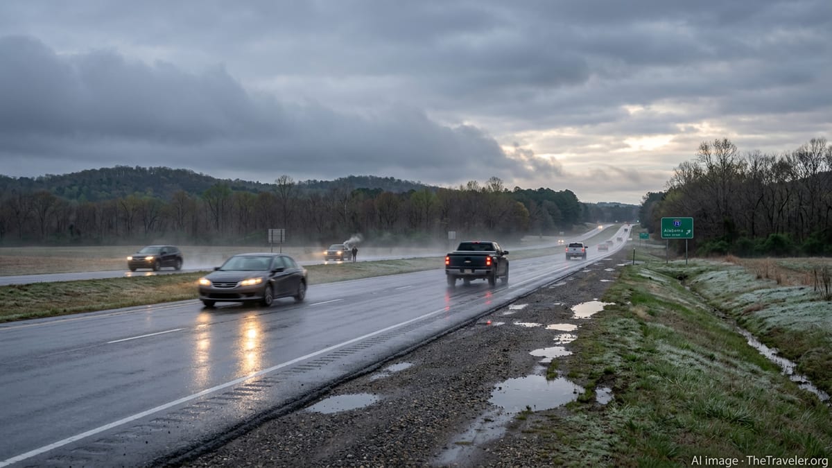
Travelers driving through Alabama or flying in and out of the state during this period may experience delays tied to heavy rain, sudden reductions in visibility, and pockets of standing water on roadways. Aviation operations at regional airports could also be affected by gusty crosswinds and thunderstorms in the vicinity, prompting temporary ground stops or rerouting.
Residents and visitors are being encouraged through public forecasts and advisories to keep a close eye on rapid changes in radar imagery and short-term updates. Conditions can deteriorate quickly with severe storms, and the fast-moving nature of the front means the window to respond to worsening weather may be limited in some communities.
Wintry Mix and Light Snow Possible in Northern Counties
As the cold front passes and much colder air rushes into Alabama, temperatures are expected to tumble sharply. Forecast discussions indicate that in the northern tier of the state, near the Tennessee border and in higher elevations, rain may briefly transition to a wintry mix or light snow as the deeper moisture begins to exit. Any accumulation is expected to be light, but even a minor coating can create slick spots, especially on bridges and overpasses.
The timing of this wintry phase appears most likely from late night into early morning, when surface temperatures are dropping fastest. This raises concerns for overnight and early-commute travelers, particularly on secondary roads that may not respond as quickly to changing conditions. Drivers unfamiliar with winter weather in the Deep South may underestimate how quickly wet roads can turn slippery when temperatures fall below freezing.
While widespread, heavy snowfall is not anticipated, the changeable conditions themselves pose a challenge. Parts of the state may see thunderstorms and temperatures in the 60s or 70s during the day, followed by flurries and readings near or below freezing within a relatively short span of time. This kind of rapid swing can catch travelers off guard, especially those passing through Alabama as part of longer interstate routes.
Forecasters are emphasizing that even if snowfall is limited, cold air arriving on the heels of departing rain could result in patches of black ice where temperatures drop quickly. Elevated stretches of interstate and shaded rural roads in northern Alabama merit particular caution as the colder air settles in.
Hard Freeze Threat Extends Across Much of the State
Behind the storm system, a strong push of Arctic air is expected to spill deep into Alabama, producing a hard freeze for many locations that have already begun their spring warm-up. Nighttime lows are projected to fall into the 20s across large portions of the interior, with some colder pockets possible in valleys and higher terrain. Even along the Gulf Coast, temperatures are forecast to dip significantly compared with recent days.
This hard freeze comes at a sensitive time of year, as many landscapes across Alabama are already showing early-season blooms, budding trees, and planted gardens. A sudden drop well below freezing can damage ornamental plants, fruit trees, and early crops, with potential ripple effects on agritourism sites and local markets that draw visitors during the spring season.
Travelers using campgrounds, state parks, or rural lodging are likely to encounter frosty mornings, frozen ground, and the possibility of icy patches on walkways and unpaved access roads. Outdoor water lines and hoses at cabins, RV parks, and vacation rentals may be vulnerable to freezing if not properly insulated, affecting basic services for guests.
Public messaging from weather services and local outlets is highlighting the need to safeguard pets, exposed pipes, and sensitive vegetation before the coldest nights arrive. For those visiting Alabama during this period, the freeze will feel especially stark following the mild, humid conditions often associated with early spring in the region.
Travel and Tourism Plans Face Rapidly Changing Conditions
The back-to-back sequence of severe storms, a brief wintry turn in the north, and a widespread hard freeze could complicate travel and tourism plans across Alabama for several days. Outdoor festivals, sporting events, and scenic drives that rely on stable spring weather may face postponements, reduced attendance, or chilly conditions that contrast sharply with expectations for mid-March.
Major travel corridors, including key interstate routes crossing the state, are likely to experience varying impacts over a short time frame: heavy rain and thunderstorms during the frontal passage, followed by gusty winds and falling temperatures, then early-morning frost or ice in certain areas. Visitors making road trips through the South may need to adjust departure times or routes to sidestep the most hazardous conditions.
Urban centers such as Birmingham, Montgomery, and Mobile could see disruptions to routine commutes and short-distance travel as storms move through, particularly during peak hours. After the frontal passage, calmer but sharply colder weather is expected to dominate, shifting the focus from immediate storm hazards to lingering cold-related concerns such as icy patches and wind chills.
In popular outdoor destinations, including lakes, state parks, and coastal areas, the volatile pattern may curtail boating, hiking, and beach plans. Travelers are being urged through public forecasts and advisories to pack for a wide range of weather conditions, from rain gear and layers for thunderstorms and wind to cold-weather clothing suitable for freezing mornings.
How Visitors and Residents Can Prepare
Given the diversity of hazards expected in such a short period, preparation is being framed as a multi-step process rather than a single action. For the severe weather phase, guidance from public information campaigns stresses the importance of monitoring radar and local alerts, knowing safe indoor locations, and avoiding flooded roadways. Travelers are encouraged to plan fuel stops and overnight stays with the storm timing in mind, reducing the chance of being on the road during the most intense activity.
As the system transitions to colder conditions and possible wintry precipitation in the north, motorists are advised to slow down, leave extra space on bridges and overpasses, and watch for changing road textures that may signal ice. Rental car users unfamiliar with local conditions may benefit from checking vehicle tire condition and defrost systems before setting out on early-morning drives.
Looking ahead to the hard freeze, both residents and visitors can take steps such as protecting outdoor taps where possible, bringing sensitive potted plants indoors, and preparing extra layers or blankets, especially in lodging that may not typically require heavy heating in March. Those staying in cabins, RVs, or older accommodations should verify that heating systems are in good working order before overnight temperatures plunge.
With Alabama poised to experience a rapid shift from storms and warm air to snow chances and freezing temperatures, the core message from public weather information is to stay flexible and informed. By checking updated forecasts frequently and building extra time into travel plans, visitors and locals alike can better navigate a week of unusually volatile conditions across the state.