
The canals of Amsterdam are at once the city’s circulatory system and its calling card. From the horseshoe curve of the 17th century canal belt to the narrow waterways of the Jordaan, they shape how the city looks, breathes and moves. To stroll across one of the city’s 1,500 or so bridges or glide beneath them on the water is to encounter Amsterdam’s history in motion: trade and engineering, wealth and hardship, strict planning and organic growth, all reflected back off the water’s surface.
How a Marsh Became a Canal City
Amsterdam’s canal story begins long before the elegant townhouses and tour boats. The city grew out of reclaimed marshland near the mouth of the Amstel River, where settlers in the Middle Ages built dikes and dug simple drainage ditches to keep their feet dry. Over time, these ditches evolved into rudimentary canals that helped manage water levels in a low-lying landscape vulnerable to flooding from both river and sea.
By the 14th century, several of the oldest canals in the historic center were already in place. The Oudezijds Voorburgwal, often cited as Amsterdam’s oldest canal, was dug in the late 14th century as part of a system of defensive works and drainage channels. In those years, canals served multiple practical purposes at once: fortification, firefighting reservoir, open sewer and transport corridor. The water was a working surface, not yet a picturesque backdrop.
As Amsterdam’s trade boomed in the 16th century, the city outgrew its medieval shell. Ships brought grain, timber, spices and textiles from across Europe and beyond, and the population surged. The narrow ring of older canals and alleys could not cope with the pressure. City leaders understood that if Amsterdam was to retain its commercial edge, it needed an ambitious plan for expansion, and water management had to be at the heart of it.
That plan arrived in the early 17th century, during what is now known as the Dutch Golden Age. Merchants and magistrates commissioned surveyors, hydraulic engineers and urban designers to create a new kind of city plan: a calculated combination of defense, drainage and high-status residential development that would become the famous canal belt. The result would fundamentally reframe Amsterdam’s identity, both in its own time and for centuries to come.
The Masterstroke: The 17th Century Canal Belt
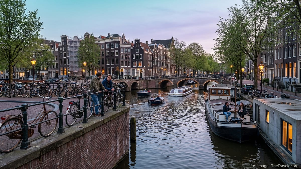
The defining feature of Amsterdam’s waterway layout is the semi-circular ring of three great canals curving around the old center: Herengracht, Keizersgracht and Prinsengracht. Together with the earlier Singel, which once formed the medieval defensive moat, they form the Grachtengordel, or canal belt, dug in phases from around 1613 onwards.
This design was far from organic. City planners plotted a series of parallel canals arcing out from the Amstel in a careful geometry that allowed for gravity-based drainage and efficient circulation. Cross streets and radial canals intersected the rings at regular intervals, creating blocks well suited for orderly development. The soil excavated to dig the canals was used to raise building plots and embankments above flood-prone levels, reinforcing the engineering logic of the plan.
Each ring carried a social function as well. The Herengracht, closest to the medieval center, was designed as a prestigious residential canal for the governing elite and wealthiest merchants. Grand canal houses with ornate gables and deep plots lined its quays, particularly along the stretch later dubbed the “Golden Bend.” Keizersgracht and Prinsengracht, progressively further out, attracted prosperous traders, artisans and small-scale industry. The rings were at once a hydraulic system and a social map etched into water.
Today, walking these canals reveals the clarity of that 17th century concept. Despite later infill, widening and rebuilding, the underlying pattern remains intact, with almost mathematical regularity in the spacing of bridges, intersections and plots. It is this coherence that helped earn the “Seventeenth-century canal ring area of Amsterdam inside the Singelgracht” UNESCO World Heritage status in 2010, recognized as a masterpiece of combined urban design and hydraulic engineering.
Understanding the Layout: Rings, Radials and Hidden Corners
For visitors, Amsterdam’s canal map can seem tangled at first glance, but it follows a logic that quickly becomes intuitive. Imagine the medieval core around Dam Square and the Oude Kerk as a roughly triangular island. Around this older center the canal belt curves in a horseshoe, open toward the Amstel. The Singel forms the innermost water boundary of the belt, followed by Herengracht, Keizersgracht and Prinsengracht outward toward former pasturelands.
Cutting across these concentric canals are a series of radial waterways and streets that run roughly perpendicular to the river. Brouwersgracht in the northwest and the Amstel itself in the southeast anchor the belt. Smaller cross-canals such as Leidsegracht and Vijzelgracht stitch the rings together and historically formed key east–west movement corridors. If you picture the old city like a spider’s web, the rings are the circular strands and the radials are the spokes.
Beyond the formal canal belt, additional watercourses weave through neighborhoods that grew up more informally. The Jordaan, to the west of Prinsengracht, was once a working-class quarter of narrow canals, small workshops and crowded housing. Several of its canals have been filled in over the centuries, turned into streets when water management and transport patterns changed. Yet enough waterways remain, such as Bloemgracht and Egelantiersgracht, to preserve the area’s intimate, almost village-like character.
To the east, the smaller canals of the former Jewish Quarter and the Plantage district reveal another side of Amsterdam’s layout, where horticultural gardens, warehouses and later cultural institutions replaced the grand houses of the Herengracht. Across the IJ, the broad tidal inlet that serves as the city’s northern waterfront, modern developments add new basins and marinas to the historical water network, extending canal culture into once-industrial zones.
Numbers That Tell the Story
Amsterdam’s canal system is impressive not just visually but statistically. The city today has around 165 named canals with a combined length of roughly 100 kilometers, traced primarily within the central boroughs. Where these waterways intersect, split and wrap around islands, they create a patchwork of some 90 small urban “islands” separated by water.
Spanning these channels is a dense lattice of bridges that has earned Amsterdam its reputation as one of Europe’s most walkable water cities. Depending on how you count, the city manages well over a thousand bridges, from simple stone arches to wrought-iron drawbridges. The municipality’s core inventory lists more than 1,200 official bridges, while broader counts that include smaller pedestrian spans and culverts put the total closer to 1,900 or more. Even the conservative figures mean that, in theory, you could cross a different Amsterdam bridge every day for several years without repeating yourself.
Structures along the canals reflect a similar density of heritage. Within the World Heritage canal belt alone, nearly 8,000 protected monuments line the water. These range from merchant palaces and former warehouses to churches, guildhalls and modest workers’ dwellings squeezed between their more opulent neighbors. Together they form one of the most extensive ensembles of early modern urban architecture anywhere in Europe.
The physical dimensions of the main canals also tell you something about their design intent. In the 17th century, they were engineered wide and deep enough for freight barges and timber rafts to navigate safely, but narrow enough to keep quayside distances walkable and crossing bridges affordable. That balance, set centuries ago, still governs how the water is used today, from sightseeing boats to small electric runabouts threading their way beneath low arches and past houseboats.
Working Water: From Trade Artery to Urban Living Room
Originally, Amsterdam’s canals were instruments of commerce. Barges once delivered goods directly to canal houses, where winches and hoist beams still visible above gables were used to haul barrels, bales and crates into attic storage. Timber floated in from the Baltic, grain arrived from the Baltic and Poland, and luxury goods like spices and silks came via the city’s vast maritime networks. For centuries, water was the quickest and most efficient way to move heavy cargo in and out of a dense city center.
At the same time, the canals served as drainage and sewage conduits, receiving waste from households and workshops. This double role as lifeline and open sewer was not unique to Amsterdam, but it created notorious pollution problems. Over time, investments in locks, pumping stations and later modern sewage systems gradually turned the canals from foul-smelling hazards into cleaner, better circulated water bodies. By the late 20th century, water quality had improved enough that fish returned in large numbers and, on hot days, even swimming became more common.
Today, the canals are no longer industrial arteries but urban living rooms. Cargo barges have given way to passenger boats, private sloops, paddleboarders and kayakers. Houseboats moored along many canals transform the water’s edge into an elongated floating neighborhood. Some of these vessels are converted barges; others are purpose-built concrete hulls with modern amenities. Their presence, regulated by strict mooring and licensing rules, adds a domestic, even bohemian, layer to the historic streetscape.
Despite this shift toward leisure, the canals remain regulated pieces of critical infrastructure. Water levels are carefully managed through locks and sluices that connect the network to the IJ and regional polders. Municipal engineers must constantly monitor subsidence, quay wall stability and bridge safety. Recent surveys have led to multi-year programs of quay and bridge reinforcement, as aging brickwork and timber piles show the stress of centuries of use, heavy traffic and changing groundwater levels.
What Makes Amsterdam’s Canals Unique
Many European cities boast beautiful waterways. Venice has its lagoon, Bruges its intimate channels, Copenhagen its harbors. Amsterdam’s canals stand apart in the way they blend strict planning with everyday livability. The Grachtengordel was not just incremental growth along a river; it was one of the first large-scale, fully planned urban expansions in early modern Europe, conceived as a cohesive hydraulic and social design that remained largely intact.
Another distinguishing feature is the way the canals structure daily life. In Amsterdam, water is not a backdrop that you occasionally glimpse. It is something you cross dozens of times a day on foot or by bicycle, and something you navigate alongside as you move through the city. The narrowness of the streets and the closeness of the water’s edge bring pedestrians, cyclists and boaters into constant visual contact, creating a sense of human-scale intimacy rare in a capital city.
The city’s architecture reinforces this uniqueness. The long rows of canal houses form an almost continuous urban “theater set,” with slender plots, tall facades and decorative gables framing the water. Because the houses tilt subtly forward or sideways over centuries of settling, and because owners have adapted them in countless small ways, the result is a streetscape that feels both harmonious and individual. Reflections in the water double the visual effect, particularly at night when windows and bridge lamps light up.
Finally, Amsterdam’s canals are unusual for the degree to which they have been integrated into contemporary sustainability efforts. The city has embraced the waterways as a testing ground for electric mobility, urban ecology and climate adaptation. Initiatives range from zero-emission tour boats and floating waste collectors to experiments with waterborne logistics, treating canals as green corridors in both an environmental and a social sense.
Canal Culture Today: Boats, Bridges and Everyday Rituals
To understand the canals as a visitor, it is worth paying attention not only to the water itself but to how residents use it. On summer evenings, small open boats packed with friends drift past with picnic baskets and soft music, pausing to chat with people sitting on quayside benches or houseboat decks. In winter, when temperatures drop low enough to form ice, locals instinctively look to the canals and wonder if skating might be possible, reviving a tradition that remains powerful in the Dutch imagination even if truly hard freezes are less frequent.
Several festivals and citywide events either center on or incorporate the canals. During major celebrations, flotillas of boats become mobile party spaces, and decorated bridges provide natural viewing stands. Illumination projects in the darker months turn the water into a canvas for light art, with installations projecting, reflecting or hovering just above the surface. These events emphasize how fully the canals belong to the city’s shared cultural life, not just its tourism industry.
At the same time, the city has had to confront the pressures that intensive canal use brings. Amsterdam’s popularity as a city-break destination has made sightseeing boats a near-constant presence on some routes, while privately rented party boats can generate noise and congestion. Residents living along busy stretches have pushed the municipality to introduce stricter rules, from maximum speeds to limits on amplified music and alcohol consumption on board.
The result is a delicate balancing act: keeping the canals open, lively and economically productive while preserving quality of life and the fragile historic fabric. Recent court cases and policy debates about tour boat permits, houseboat regulation and maximum vessel sizes show how central the waterways remain to the city’s identity and politics. When Amsterdam negotiates its future, it often does so through discussions about what should and should not happen on its canals.
Environmental Challenges and the Move to Cleaner Canals
Like any historic infrastructure, Amsterdam’s canals face 21st century challenges that their designers could not have anticipated. Climate change and heavier rainfall events put extra strain on the drainage function, forcing the city to rethink storage capacity and overflow routes. At the same time, subsidence and aging foundations threaten quay walls and bridge piles, prompting large-scale reinforcement works that inevitably disrupt traffic and canal views but are necessary for long-term safety.
Water quality, though dramatically improved compared with a century ago, remains a constant concern. Runoff from streets, waste from pleasure craft and the sheer intensity of boat traffic all require monitoring and mitigation. Floating trash is a visible symptom, but less visible pollutants such as fuel residues and microplastics are equally on officials’ radar. Anti-litter campaigns and dedicated cleanup boats now patrol the canals regularly, and awareness among residents and visitors about their impact on the water continues to grow.
One of the most visible shifts is the move toward clean boating. The city has been tightening emissions rules on the waterways for years, pushing commercial tour operators to transition from diesel to electric propulsion and restricting older two-stroke outboard engines. For visitors, this translates into quieter, smoother canal cruises with minimal exhaust fumes, a marked contrast to the diesel-chugging boats of the past.
Looking ahead, further measures are coming into force that will bar traditional combustion engines from the inner canals in favor of electric, hydrogen-powered or otherwise zero-emission vessels. At the same time, Amsterdam is working on installing adequate charging facilities and shore power connections to support this transition. The long-term aim is a canal system that contributes to, rather than detracts from, the city’s climate and livability goals, while remaining accessible to both residents and guests.
Navigating the Canals as a Visitor
For travelers, Amsterdam’s canals are more than a scenic backdrop; they are a practical way to orient yourself and experience the city on a human scale. Traditional glass-roofed tour boats offer an efficient introduction, circling the main canal belt and highlighting key architectural and historical points. Smaller open boats and intimate guided cruises provide a quieter, more flexible alternative, often reaching narrower canals that larger vessels cannot enter.
Self-drive rental boats and pedal boats give visitors the chance to take the helm, but they also come with responsibilities. The city’s boating rules require skippers to adhere to low speed limits, stay on the right, give way to larger commercial vessels and minimize noise for residents. Alcohol restrictions apply to operators, and mooring is only allowed at designated places with appropriate permits. For those unfamiliar with boating, it can be worth choosing a trip with a professional skipper who knows the rules, depths and traffic patterns.
Exploring on foot or by bicycle along the canals can be just as rewarding, especially if you focus on a particular stretch rather than trying to cover everything at once. A slow walk along Herengracht between Brouwersgracht and Vijzelstraat, for example, reveals some of the grandest Golden Age facades, while a stroll along Brouwersgracht and into the Jordaan showcases a more informal, residential side of canal life. Early morning and late evening are especially atmospheric times, when commuter traffic subsides and the water mirrors a softer light.
In all cases, treating the canals as lived spaces rather than simply a backdrop for photos helps preserve their character. Remember that the people whose houseboats and canal-side homes you pass are not props in a postcard but neighbors going about their daily lives. Keeping noise down, observing local etiquette and supporting responsible operators are small but significant ways to contribute to the future of the canals you came to enjoy.
The Takeaway
Amsterdam’s canals are much more than a picturesque grid of waterways. They are the outcome of centuries of negotiation with water, commerce and community, a sophisticated 17th century engineering solution that still structures city life in the 21st century. The concentric canal belt, the fine-grained network of cross-canals and bridges, and the dense fabric of canal houses all testify to a remarkable period of vision and investment that gave Amsterdam its enduring shape.
What makes these canals truly distinctive, though, is how alive they remain. Boats still pass beneath low arches every few minutes, residents still sit on stoops with their feet almost touching the water, and city officials still debate how best to protect and adapt the network for a future of climate uncertainty and sustainable mobility. For visitors who take the time to look beyond the postcard view, the canals offer a layered story about planning and improvisation, power and everyday life, conservation and change.
To walk, cycle or sail along Amsterdam’s canals is to move through a living world heritage site in real time, where history is not sealed behind museum doors but reflected in the water that still flows beneath your feet. Understanding how and why those canals came to be, and what it takes to keep them functioning today, deepens that experience and reveals a city that has always been, and remains, shaped by water.
FAQ
Q1. How many canals are there in Amsterdam?
Amsterdam has roughly 165 named canals within its central area, with a combined length of about 100 kilometers. Smaller ditches, harbors and basin-like waterways sit outside this core figure, but the 165 main canals form the recognizable historic network visitors explore today.
Q2. Why were Amsterdam’s canals originally built?
The canals were built primarily for water management, defense and transport. In a low-lying marshy environment, they helped drain land and control flooding, formed defensive moats around the city and provided efficient routes for moving goods and people at a time when roads were poor and heavy loads were easier to move by water.
Q3. What is the Grachtengordel?
The Grachtengordel, or canal belt, refers to the semi-circular ring of major canals built in the 17th century around Amsterdam’s medieval center. It includes, from inside to outside, the Singel, Herengracht, Keizersgracht and Prinsengracht. This planned expansion is recognized as a UNESCO World Heritage site due to its combined urban, architectural and hydraulic significance.
Q4. Are the canals natural rivers?
No, Amsterdam’s canals are artificial waterways created by human engineering. They were dug through marshes and reclaimed land, connected to natural rivers and lakes via locks and sluices, and constantly managed to maintain stable water levels. Their curves and intersections follow a designed plan rather than natural river courses.
Q5. Can you swim in the canals?
While organized events sometimes include supervised canal swims and locals do occasionally take a dip on very hot days, casual swimming is not officially encouraged everywhere. Water quality has improved significantly, but currents, boat traffic and hidden obstacles can make swimming risky. Visitors should always check local guidelines and avoid entering busy navigation channels.
Q6. Why do some canals in Amsterdam no longer exist?
Over the centuries, several canals were filled in and turned into streets, particularly in working-class districts like the Jordaan. This happened for reasons including poor water quality, the rise of road transport and public health concerns. The infilled waterways often retain “gracht” or related names, hinting at their canal past even though they are now paved.
Q7. What are the houseboats on the canals?
Houseboats in Amsterdam are floating homes moored along many of the city’s canals. Some are converted cargo barges; others are modern floating structures built specifically for residential use. They are highly regulated, with permits controlling their number and locations, and together they create distinctive linear neighborhoods on the water.
Q8. How is boat traffic on the canals regulated?
Boat traffic is governed by speed limits, right-of-way rules, noise restrictions and licensing requirements. Skippers must obey low speed limits, stay on the right, give way to larger vessels and observe designated routes and mooring rules. Commercial tour boats operate under separate permits, and the city is gradually tightening environmental standards for engines.
Q9. Why is Amsterdam moving toward electric boats?
Amsterdam is encouraging or requiring a shift to electric and other zero-emission boats on its canals to reduce air and noise pollution and help meet broader climate targets. Traditional diesel engines contribute to emissions and can be noisy in narrow waterways lined with housing. Electric boats provide a quieter, cleaner experience for both residents and visitors.
Q10. What is the best way to experience the canals as a first-time visitor?
A classic option is to take a guided canal cruise that circles the historic belt and explains key landmarks. After that, exploring on foot or by bicycle along selected stretches, such as parts of Herengracht or the canals of the Jordaan, lets you appreciate the architecture and everyday life at a slower pace. Choosing responsible operators and respecting local rules helps ensure that the canals remain enjoyable for everyone.