
More news on this day
An extended blast of arctic air is colliding with fresh rounds of snow and ice across the Cincinnati metro and the broader Tri State region of Ohio, Kentucky and Indiana, triggering a tangle of snow emergencies, hazardous road conditions and mounting disruptions to travel.
As counties shift in and out of formal advisories, residents find themselves navigating a confusing patchwork of local rules while still reeling from the deadly January winter storm that killed more than 150 people nationwide and froze transportation networks from the Midwest to New England.
More News
- Caribbean Travel to U.S. Upended by New Visa Freezes and Expanded Bans
- Mexico Restores E-Visas for Brazilians, Paving the Way for Borderless Tourism
- Philippine Airlines Joins Regional Carriers Powering Southeast Asia’s Tourism Boom
Region on Edge After Deadly January Winter Storm
The latest snow emergencies in the Cincinnati area come less than two weeks after a sprawling late January winter storm, described by forecasters as potentially historic, buried much of the United States under snow and ice. That system prompted emergency declarations from more than 20 governors, caused more than 10,000 flight cancellations in a single day and knocked out power to more than a million customers at its peak. The death toll has climbed past 150, making it the deadliest North American winter storm since the 2021 Texas power crisis.
Ohio, Indiana and Kentucky were all swept up in that wave of severe weather. Indiana’s governor issued a statewide disaster declaration following widespread heavy snow, while Ohio’s governor declared a state of emergency as ice and whiteout conditions spread along major travel corridors. In Kentucky, where at least 16 storm related deaths have been recorded, stretches of highway and secondary roads were periodically impassable and emergency crews struggled to keep pace with collisions and stranded motorists.
Although Cincinnati itself avoided the very worst of the January storm’s totals, the metro area saw days of treacherous pavement, recurring crashes and intermittent power and communication issues. The memory of jackknifed semis blocking interstates and emergency vehicles inching along icy hills is still fresh, leaving public officials and residents acutely sensitive to any new round of winter alerts.
That lingering anxiety is now coloring the response to the current arctic outbreak and its associated snow, as Tri State communities brace for conditions that, while less extreme than last week’s peak, are still dangerous enough to cripple local travel and threaten vulnerable residents.
Arctic Blast Locks In Brutal Cold Over Cincinnati
On Monday night and into Tuesday, a fresh surge of arctic air settled over the Ohio River Valley, keeping the Cincinnati region in a deep freeze even as the heaviest snow began to ease. Forecasters report highs stuck in the 20s for several days, with lows dipping into the teens and single digits in outlying areas. Wind chills have made it feel even colder, especially during the early morning commute and overnight hours.
Local meteorologists say this latest cold spell is part of the same pattern that fueled the late January storm, with frigid air from the Arctic spilling south and colliding with a series of fast moving disturbances. For the Cincinnati area, that has meant multiple rounds of light to moderate snow on top of already frozen ground, creating a persistent glaze of ice on less traveled streets, neighborhood hills and rural routes.
A Winter Weather Advisory remains in effect for portions of southeast Indiana, northern Kentucky and parts of Ohio, reflecting the mix of snow covered roads, refreezing slush and the risk of black ice. Even where snow intensity has dropped, temperatures are too low for chemical treatments to work quickly, forcing plow crews to rely heavily on mechanical clearing and sand.
While forecasters hint at a modest warmup late in the week, with the possibility of temperatures briefly reaching the mid 30s and even 50s the following week, officials warn that the immediate focus must remain on surviving three more days of deep cold. Overnight lows well below freezing will allow even minor meltwater to refreeze, resetting the hazard each morning and extending the threat of spin outs and fender benders on untreated surfaces.
Patchwork of Snow Emergencies and Travel Advisories
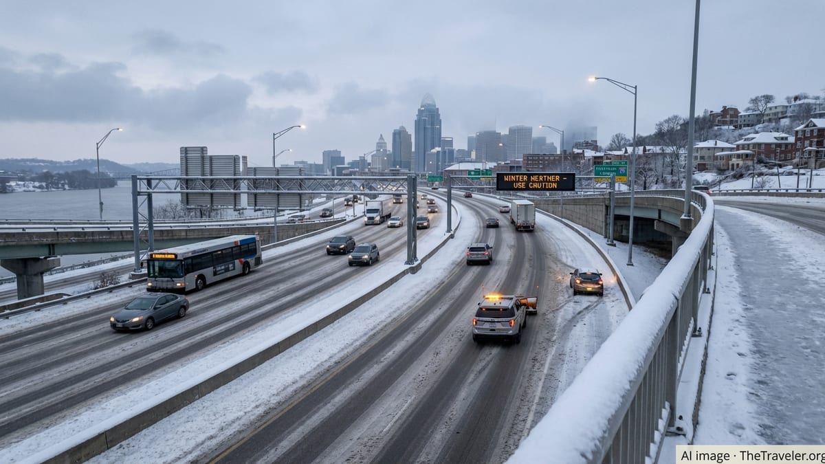
Across the Greater Cincinnati area, residents woke Tuesday to a shifting mosaic of snow emergencies and travel advisories, as county and city leaders responded to evolving road conditions. In Ohio, several counties including Adams, Clinton and Highland recently maintained Level 1 snow emergencies, while the city of Cincinnati itself declared a local snow emergency that restricts parking along designated snow routes to clear space for plows.
In northern Kentucky, counties such as Bracken, Gallatin, Grant, Owen and Pendleton have at times moved into Level 1 snow emergencies, urging caution and limiting street parking in problem zones. Pendleton County has gone as high as Level 3 at points, effectively closing roads to non emergency travel and warning residents that venturing out without urgent cause could subject them to enforcement measures.
On the Indiana side of the river, counties including Dearborn, Franklin, Ohio, Union, Ripley and Switzerland have cycled through yellow and orange travel advisories. Under Indiana’s color coded system, yellow advisories urge heightened caution and limited travel, while orange advisories strongly discourage driving and recommend that people stay home unless absolutely necessary. Switzerland County has at times remained under an orange advisory while others have downgraded.
The rapid pace of change, with some jurisdictions rescinding or downgrading their snow emergencies even as neighboring areas tighten restrictions, has left many commuters uncertain about what is permitted and where. Local television stations and radio outlets are dedicating continuous coverage to updating county by county conditions, but late night and early morning shifts remain especially challenging as conditions can worsen faster than public messaging can be updated.
Road Crews Race Conditions as Crashes Mount
As snow bands moved through and then tapered off, transportation departments on all three sides of the Ohio River scrambled to keep primary routes passable. Plow drivers in Cincinnati and Hamilton County concentrated on major interstates, bridges and key arterials, while suburban and rural crews spread out along hilly neighborhood streets and winding county roads that quickly become skating rinks in arctic outbreaks.
Officials report dozens of crashes and slide offs across the Tri State in recent days, including multi vehicle wrecks along stretches of interstates 71, 74 and 75 and numerous minor collisions on secondary roads. Emergency dispatch logs show a familiar pattern of trouble spots: on and off ramps, bridge decks, shaded curves and steep neighborhood hills where even all wheel drive vehicles can lose traction in a matter of seconds.
Although the current system has not produced the crippling, hours long interstate shutdowns seen during the late January storm, authorities say the potential remains anytime a sudden burst of heavier snow coincides with peak travel times. One lingering concern is the presence of packed snow left from earlier events, which can act as a slick, compact base under any new accumulation and make it harder for plows to clear down to bare pavement.
City officials in Cincinnati and nearby municipalities have again activated snow emergency parking rules on designated routes. Vehicles left on those streets risk ticketing or towing so that plows can make repeated passes. In some smaller jurisdictions, police have begun door to door notifications or social media blitzes to get cars moved before overnight snow refreezes into hard ruts and berms.
Air, Rail and Bus Travelers Face Disruptions
The Cincinnati/Northern Kentucky International Airport has thus far avoided the wholesale shutdowns that paralyzed major hubs during the late January winter storm, but the latest arctic blast has still led to delayed departures, extended deicing times and a ripple of schedule changes. Airlines are juggling aircraft and crews that are still out of position after thousands of weather related cancellations across the country in recent weeks.
Passengers report lines at ticket counters and service desks as carriers consolidate lightly booked flights and rebook travelers misconnected by upstream delays. While runway clearing at CVG has remained relatively efficient, problems at origin and destination airports affected by the same cold pattern have caused cascading disruptions. Airlines have reminded customers to monitor their apps closely and arrive early, anticipating longer security and boarding processes when winter conditions are active.
Intercity bus and rail services have not been spared. Regional bus lines serving Cincinnati, Lexington, Louisville, Indianapolis and Columbus have canceled or re timed runs on days when road conditions deteriorate quickly. Slower traffic and jackknifed trucks on main corridors can add hours to what would otherwise be routine trips, straining driver hour limitations and forcing mid route rest periods.
Rail passengers are also encountering lingering delays as freight and passenger operators work through congestion and weather damaged infrastructure stemming from the wider January storm. Even where tracks are clear, speed restrictions are common in extreme cold to reduce the risk of rail defects and braking issues, stretching timetables and cutting into tight transfer windows.
Public Health, Homeless Shelters and Power Grid Under Strain
The arctic blast and its accompanying snow emergencies are putting renewed pressure on public health resources and social services in the Cincinnati region. Cold related injuries such as frostbite and hypothermia remain a concern, particularly among people experiencing homelessness, the elderly and households facing energy insecurity. Hospitals and urgent care centers have seen a mix of weather related slips and falls, minor crash injuries and respiratory complaints exacerbated by the cold, dry air.
Local governments and nonprofit organizations in Hamilton County and northern Kentucky counties have opened or expanded warming centers and emergency shelters, extending hours and adding cots where possible. Outreach teams are canvassing encampments and underpasses, offering transportation to shelters as nighttime wind chills plunge. Some counties have partnered with faith based groups to convert church halls and community centers into temporary overnight refuges.
So far, the regional power grid has largely held, avoiding the extensive blackouts that plagued southern states and parts of the Ohio River basin in late January. Utilities credit aggressive tree trimming, staggered maintenance schedules and lessons learned from past cold snaps. Nevertheless, scattered outages are being reported as ice and heavy, wet snow accumulate on smaller lines, and utility crews are operating under extended shifts to restore service before indoor temperatures can drop to unsafe levels.
Emergency management officials caution that even brief power interruptions can be dangerous when outdoor temperatures are in the teens. They are urging residents to check on neighbors, particularly older adults and people with disabilities, and to use space heaters, fireplaces and generators with extreme care to avoid fires and carbon monoxide poisoning.
Travel Guidance for Residents and Visitors
With overlapping advisories and rapidly changing conditions, local officials are pressing both residents and visitors to prioritize safety over rigid travel plans. In counties under Level 1 emergencies or yellow advisories, motorists are advised to stay off the roads unless travel is necessary and to use extra caution if they must drive. Level 2 or orange advisories raise the bar, strongly encouraging people to remain at home and restricting travel to essential trips only.
Those who do venture out are being urged to slow down considerably, increase following distances and assume that any untreated surface may be slick. Emergency responders emphasize that many winter crashes occur not during the height of snowfall, but in the hours after precipitation ends, when drivers mistakenly believe the danger has passed while invisible black ice is forming in shaded areas and on bridges.
For out of town travelers planning to fly in or out of Cincinnati, transportation officials recommend building flexibility into itineraries. That includes booking earlier flights where possible, allowing large buffers between connections and confirming ground transportation options that can adapt to changing road conditions. Travelers heading to nearby cities such as Louisville, Lexington, Dayton or Indianapolis by car are also being told to monitor state transportation agency updates, as conditions can deteriorate quickly a short distance from the relatively milder Ohio River corridor.
Employers across the Tri State region are once again dusting off remote work policies and flexible scheduling arrangements used extensively during the pandemic and previous winter storms. Businesses that can operate virtually are being encouraged by local leaders to do so on the coldest and most hazardous days, both to reduce the risk to employees and to ease the burden on still stretched road crews and first responders.
FAQ
Q1: What is a Level 1 snow emergency or yellow travel advisory in the Cincinnati Tri State area?
In most Ohio counties and nearby Kentucky jurisdictions, a Level 1 snow emergency or yellow travel advisory means roads are hazardous due to snow or ice and drivers should use heightened caution. Travel is not banned, but motorists are urged to limit trips, allow extra time and be prepared for slick spots, especially on secondary roads and bridges.
Q2: How is a Level 2 or orange advisory different from Level 1?
A Level 2 snow emergency or orange travel advisory indicates that road conditions have deteriorated to the point where travel should be restricted to essential purposes only. Drivers are strongly encouraged to stay home if they can, and those who must travel should expect significantly reduced speeds, poor visibility and the possibility of blocked or partially cleared lanes.
Q3: What does a Level 3 or red travel advisory mean for drivers?
A Level 3 snow emergency or red travel advisory effectively closes local roadways to non emergency traffic. Only emergency vehicles and individuals with urgent, unavoidable reasons to travel should be on the roads. In some jurisdictions, motorists who ignore Level 3 restrictions can face fines or other penalties if they become stranded and require rescue.
Q4: Are flights at Cincinnati/Northern Kentucky International Airport being canceled?
While the airport has avoided a full shutdown, the arctic blast and recurring snow have led to scattered delays and some cancellations, especially when combined with disruptions at other hubs affected by the same weather pattern. Travelers are advised to check with their airline frequently on the day of departure and to arrive early to allow for deicing and longer processing times.
Q5: Is it safe to drive between Cincinnati and nearby cities like Louisville, Lexington or Indianapolis right now?
Conditions vary widely depending on timing and exact route. Major interstates are a priority for plow crews, but stretches can still become icy or snow covered quickly during heavier bursts or overnight refreezing. Before starting any trip, drivers should review the latest advisories in each state, check real time traffic maps and be prepared to postpone or reroute if conditions worsen.
Q6: How long is the arctic cold expected to last in the Cincinnati area?
Forecasts suggest that temperatures will remain below freezing for several days, with highs mostly in the 20s and lows in the teens or single digits. A brief warmup into the 30s may arrive late in the week, followed by a more noticeable moderation that could bring highs into the 50s the following week, but dangerous cold will persist in the short term.
Q7: What should visitors do if their hotel or short term rental loses power during the cold snap?
Guests should first contact property management or the front desk to report the outage and get updates on restoration efforts. If indoor temperatures begin to fall quickly or if anyone in the party is medically vulnerable, visitors should consider relocating to a warming center, another hotel with power or a public facility designated by local emergency managers, and avoid using grills or generators indoors because of carbon monoxide risks.
Q8: Are public transit services in Cincinnati still operating during the snow emergencies?
Most local bus routes and transit services strive to maintain operations, though schedules may be adjusted and some less traveled routes or stops could be temporarily suspended. Riders should monitor service alerts from the regional transit authority, expect delays and dress for extended waits in subfreezing temperatures.
Q9: How can residents without garages protect their vehicles in this kind of weather?
Drivers are encouraged to park off designated snow emergency routes so plows can pass, clear snow and ice from all windows and lights before driving, and keep at least a half tank of fuel in case they are delayed. Using a windshield cover or tarp can speed deicing, and lifting wipers away from the glass before a storm can keep them from freezing in place.
Q10: What basic items should people keep in their cars during this arctic blast?
Officials recommend a winter emergency kit that includes warm clothing or blankets, gloves and hats, a flashlight, phone charger, ice scraper, small shovel, sand or kitty litter for traction, bottled water and non perishable snacks. Having these supplies on hand can make a significant difference if a vehicle becomes stranded or delayed in dangerous cold.