
From the depths of the Grand Canyon to the glowing saguaros of the Sonoran Desert, Arizona delivers some of the American Southwest’s most dramatic landscapes and cities. It is also a state of extremes, where triple-digit heat, powerful summer monsoons, and fast-changing conditions can quickly derail an unprepared trip. This guide covers the essentials you need to know before you go, blending up-to-date practical advice with ideas for making the most of your time in the Grand Canyon State.
Understanding Arizona’s Seasons and Weather
Arizona’s weather varies sharply by region and elevation, and your experience will differ greatly between low desert cities such as Phoenix and Tucson and high-country hubs like Flagstaff or Prescott. Summer in the desert, typically from late May through September, often brings extreme heat with daytime highs that can exceed 110 degrees Fahrenheit in Phoenix and other low-lying areas. In contrast, the high country can be 20 to 30 degrees cooler, with pleasantly warm days and cool nights.
From roughly June through September, the North American monsoon brings increased humidity, thunderstorms, lightning, and dust storms across much of the state. The National Weather Service identifies this as Arizona’s most hazardous weather season, with risks that include flash floods, downbursts, and sudden dust storms that can reduce visibility to near zero on highways. Travelers should monitor daily forecasts, especially if driving long distances, hiking canyons, or visiting rural areas during this period.
Winter in northern and high-elevation Arizona can be snowy and cold, particularly around Flagstaff, the Mogollon Rim, and the Grand Canyon’s rims. Snowstorms occasionally close highways and can lead to chain or traction requirements. In contrast, winter in the desert is generally mild and sunny, making it a peak season for visitors seeking warmth. Spring and autumn are often the most comfortable and predictable times statewide, though sudden cold fronts or early heat waves are still possible.
No matter when you visit, it is crucial to plan around heat and sun exposure. Local and federal agencies emphasize hydration, sun protection, and limiting mid-day exertion, particularly in summer. Simple habits such as drinking water continuously, wearing light-colored clothing, and planning strenuous hikes for early morning can dramatically reduce the risk of heat-related illness.
Current Conditions at the Grand Canyon and Other Key Parks
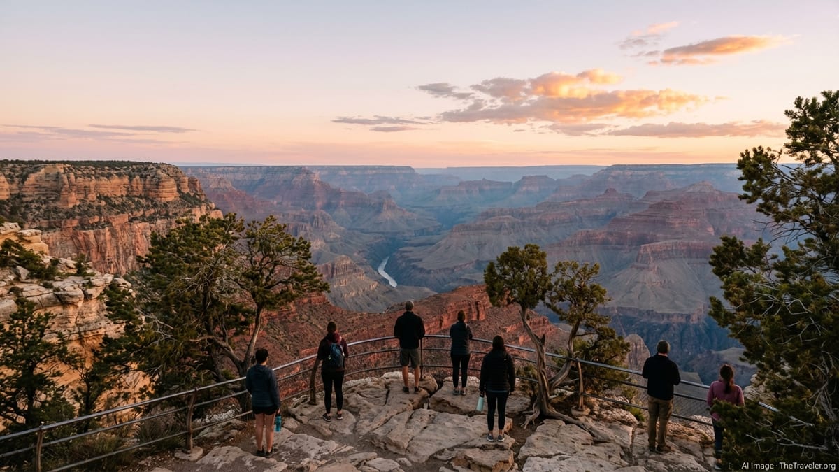
Grand Canyon National Park remains Arizona’s marquee destination, attracting millions of visitors each year. As of late 2025 and early 2026, the South Rim is open for day visitors with major viewpoints, trails, and visitor services operating, though travelers should check the National Park Service’s latest operational updates before arrival for any changes to facilities, shuttle schedules, or trail access. The park continues long-term work on the Transcanyon Waterline, which has led to intermittent restrictions and temporary suspensions of some overnight accommodations on the South Rim to conserve water.
The North Rim has been significantly affected by recent wildfires, including a large blaze in 2025 that damaged historic structures and led to extended closures. In addition to seasonal winter closures that typically run until mid-May, some access limitations and repair work may persist into the 2026 season. Travelers considering a North Rim visit should regard reopening dates as tentative and verify current conditions shortly before travel, as fire damage, weather, and infrastructure repairs can alter timelines.
Inside the canyon, iconic trails such as Bright Angel and South Kaibab on the South Rim generally remain open, though segments and connecting bridges may occasionally close for maintenance or safety reasons. Hiking to the Colorado River and back in a single day is strongly discouraged for most visitors due to heat, elevation change, and limited rescue capacity. Campgrounds and Phantom Ranch reservations are often booked well in advance and are subject to change if water restrictions tighten, so flexible planning and backup lodging in nearby towns such as Tusayan, Williams, or Flagstaff are wise.
Beyond the Grand Canyon, other major Arizona parks include Saguaro National Park near Tucson, Petrified Forest National Park along Interstate 40, and a network of national monuments and state parks that protect red rock formations, slot canyons, and historic sites. While these areas generally remain open year-round, localized closures can occur after heavy rains, snow, wildfires, or extreme heat. Checking conditions with park managers before visiting remote trails or backcountry routes is essential.
Where to Go: Regions and Highlights
Arizona can be loosely divided into three major travel regions: the low desert, the central highlands, and the Colorado Plateau in the north. The low desert includes Phoenix, Scottsdale, and Tucson, as well as surrounding communities in the Sonoran Desert. Here you will find modern resorts, golf courses, desert botanical gardens, and extensive hiking networks through saguaro-studded landscapes. In cooler months, these cities host festivals, spring training baseball, and outdoor events that draw visitors from across North America.
The central highlands around Sedona, Prescott, and Payson offer a mix of red rock formations, pine forests, and small-town charm. Sedona in particular is famous for its vivid sandstone buttes and canyon trails. The area is also marketed for wellness retreats, spas, and spiritual tourism. Because Sedona is relatively compact and popular, parking and trailhead congestion are common at peak times. Early starts and midweek visits can help reduce crowding.
Farther north, the Colorado Plateau region encompasses Flagstaff, the Grand Canyon, Page, and the Navajo Nation, among other destinations. This high-elevation landscape features vast canyons, mesas, and iconic viewpoints of the Colorado River and Lake Powell. Weather here is more variable, with cooler summers and potentially snowy winters. Many travelers use Flagstaff as a base for Grand Canyon day trips, while Page serves as a gateway to desert slot canyons and boat tours on the lake.
Smaller communities and tribal lands across Arizona, including the Hopi mesas, Tohono O’odham Nation, and other sovereign nations, offer opportunities to learn about Indigenous cultures, art, and history. Access, photography rules, and visitor services vary, so advance research and respectful adherence to local guidelines are essential when adding these experiences to an itinerary.
Practical Planning: Getting Around and When to Book
Arizona is a road trip state, and most visitors rely on rental cars to reach parks, small towns, and trailheads. Major airports in Phoenix, Tucson, and Flagstaff offer connections to U.S. hubs, with Phoenix Sky Harbor handling the majority of long-haul flights. Once on the ground, Interstate 10 and Interstate 17 serve as primary north-south routes, while Interstate 40 carries traffic across northern Arizona. Distances can be deceiving; although roads are generally well maintained, long stretches of highway pass through remote desert with limited services.
Booking rental cars, park lodges, and guided tours well ahead of peak periods is advisable. Spring, autumn, and winter holidays see heavy demand, as do popular events such as spring training baseball and major festivals. For the Grand Canyon, South Rim lodging inside the park often fills months in advance even when water-related capacity limits are not in place. If on-park accommodations are not available, planning to stay in nearby gateway towns and commuting by car or shuttle to the rim is a reliable strategy.
Travelers should also factor in driving safety during the monsoon and winter seasons. Afternoon thunderstorms can bring sudden downpours and flash floods to low-water crossings and washes, particularly in central and southern Arizona. Dust storms, known locally as haboobs, periodically sweep across highways near Phoenix and Tucson, causing near-zero visibility and multi-vehicle collisions. In northern Arizona, winter storms can rapidly change road conditions, and short-lived closures are not uncommon. Building extra time into itineraries and being prepared to delay or reroute is part of safe travel in the state.
For those who prefer not to drive, limited options exist. Shuttle services link some cities with the Grand Canyon South Rim, and guided day tours operate from Phoenix, Scottsdale, Sedona, and Flagstaff to major attractions. However, public transportation outside urban cores is thin, and rideshare options may be sparse in rural or tribal areas, especially late at night.
Staying Safe: Heat, Monsoon, and Outdoor Hazards
Arizona’s most significant travel risk is extreme heat, particularly in the low desert from late spring through early autumn. Public health and weather agencies emphasize that heat-related illness can develop quickly and that even healthy travelers are vulnerable. Recommended precautions include drinking water regularly, avoiding alcohol and excessive caffeine in the heat, wearing light, breathable clothing, and planning strenuous outdoor activities for early morning or late evening. Many local agencies advise staying indoors or in shade during mid-day hours on the hottest days.
During monsoon season, thunderstorms can produce hazardous lightning, flash flooding, and strong winds. Dry washes and slot canyons that appear safe may fill rapidly with water from storms miles away. Travelers should avoid camping in washes or close to creeks during stormy periods and never attempt to drive across flooded roads. Even shallow water can sweep away vehicles, and road surfaces under muddy water may be damaged or missing. Dust storms require particular caution for drivers; if caught in a wall of dust, authorities recommend pulling completely off the roadway, turning off lights, setting the parking brake, and waiting for conditions to improve rather than continuing at reduced visibility.
On hiking trails, dehydration, overexertion, and altitude changes are common challenges. The Grand Canyon is particularly deceptive because hikes begin with an easy descent and end with a strenuous climb back to the rim, often in hotter temperatures. Park staff repeatedly warn against trying to hike from the rim to the river and back in one day unless you are extremely fit, well-prepared, and experienced in desert hiking. Elsewhere in the state, rattlesnakes, cactus spines, and unstable rock surfaces are everyday hazards; watching where you place your hands and feet and wearing closed-toe shoes is advisable.
Travelers should also be aware of wildfire risk, which can trigger rapid closures of trails, forests, and roads, especially in dry, windy conditions. Smoke from distant fires may affect air quality and visibility even where flames are not present. Checking local fire restrictions before lighting any campfire and adhering strictly to rules on public lands is essential. In some seasons, complete fire bans are in place across large areas of forest and desert.
Culture, Indigenous Lands, and Responsible Travel
Arizona is home to numerous tribal nations, and large parts of the state are sovereign Indigenous lands with their own regulations, cultural norms, and visitor expectations. Many popular destinations, from canyon overlooks to cultural centers and artisan markets, are located on or near these lands. Visitors should approach these areas with humility and respect, recognizing that they are not simply tourist attractions but living communities with deep historical and spiritual significance.
Photography is often restricted at certain ceremonial sites, dwellings, and community areas, and in some cases, permits are required. Signs may prohibit photos, video, or drone use. When in doubt, it is courteous to ask permission before taking close-up images of individuals, homes, or ceremonies. Purchasing art, textiles, and crafts directly from local makers is a meaningful way to support communities, but bargaining styles and expectations will vary. Paying fair prices and learning about the cultural context of what you buy helps ensure that your visit has a positive impact.
Across the state’s public lands, responsible travel also means minimizing your footprint in fragile desert and canyon ecosystems. Staying on marked trails, packing out all waste, and avoiding disturbing wildlife are basic principles that help preserve landscapes for future visitors. In arid environments, even seemingly minor actions such as stepping off trail onto cryptobiotic soil or carving into sandstone can cause long-lasting damage.
Travelers can further reduce their environmental impact by limiting single-use plastics, refilling large water containers rather than buying multiple small bottles, and choosing accommodations and tour operators that emphasize sustainability. Many parks now provide recycling and refill stations, though facilities may be sparse in remote corners of the state, so advance planning is useful.
Money, Lodging, and Health Considerations
Arizona’s larger cities and major tourist towns widely accept credit and debit cards, and contactless payments are common. However, some rural areas, small businesses, and tribal enterprises may prefer cash or have limited card processing capacity, particularly if network outages occur during storms. Carrying a modest amount of cash as a backup is prudent when traveling outside urban centers.
Lodging options range from luxury resorts and branded hotels to roadside motels, short-term rentals, and campgrounds. In peak seasons, rates in popular areas such as Sedona, Scottsdale, and the Grand Canyon region can rise sharply, and minimum-stay requirements may apply. Travelers with flexible dates may find more moderate prices midweek or in shoulder seasons. Camping on public lands is a budget-friendly alternative, but it requires careful planning around water access, fire restrictions, and sudden weather shifts.
Basic healthcare is widely available in cities and larger towns, but clinics and hospitals may be sparse across remote stretches of highway and tribal lands. Travel insurance that covers medical care and evacuation from remote areas is worth considering, especially if you plan backcountry hiking, river trips, or off-road driving. Visitors with chronic conditions affected by heat, altitude, or air quality should speak with a healthcare provider before the trip and carry enough medication to cover unexpected delays.
Tap water is generally safe to drink in cities and most developed recreation areas, though temporary advisories or restrictions can occur in smaller communities and park facilities, especially when infrastructure problems or waterline repairs are underway. Carrying extra water in your vehicle and having purification tablets or a filter for remote hikes adds a layer of security.
The Takeaway
Arizona rewards thoughtful travelers with an extraordinary mix of canyon vistas, desert sunsets, mountain forests, and dynamic cities. It is a state that demands respect for its climate, landscapes, and cultures, and understanding these realities is key to a smooth trip. With careful timing, realistic planning around heat and distances, and a willingness to adjust to changing conditions, you can experience the Grand Canyon State at its best.
As you plan, think beyond simply ticking off famous viewpoints. Build in time to linger in less crowded places, to learn from local guides and communities, and to witness how fragile and resilient desert environments can be. Arrive prepared, travel responsibly, and Arizona will likely stay with you long after you leave, from the echo of your footsteps on a canyon trail to the silhouette of a lone saguaro against the evening sky.
FAQ
Q1. When is the best time of year to visit Arizona?
The most comfortable periods for many travelers are spring and autumn, when desert temperatures are milder and high-elevation areas are generally accessible, though conditions can still change quickly.
Q2. Is it safe to visit Arizona in summer?
It can be, but only with serious heat precautions. Plan activities for early morning or evening, drink water constantly, limit mid-day sun exposure, and be ready to change plans if heat advisories are issued.
Q3. Do I need a car to get around Arizona?
A car is the most practical option for reaching parks, small towns, and trailheads. Limited shuttles and tours exist, but public transport outside cities is sparse.
Q4. What should I know about visiting the Grand Canyon right now?
The South Rim is generally open for day visits, but waterline work and seasonal or fire-related issues can affect lodging and some facilities. Check current park updates shortly before your trip.
Q5. How can I stay safe during Arizona’s monsoon season?
Monitor forecasts daily, avoid flooded roads and washes, do not camp in dry streambeds, be prepared for sudden dust storms, and head indoors when thunderstorms develop nearby.
Q6. Are there any special rules for visiting tribal lands?
Yes. Tribal nations set their own regulations. Always follow posted rules, respect photography restrictions, and seek permission or guidance from local authorities or visitor centers when unsure.
Q7. What should I pack for an Arizona road trip?
Bring plenty of water storage, sun protection, layers for temperature swings, a paper map for areas without mobile coverage, and an emergency kit with basic supplies.
Q8. Is tap water safe to drink in Arizona?
In cities and most developed areas it is generally safe, though occasional local advisories or restrictions can occur. In remote or backcountry settings, treat or filter water before drinking.
Q9. How far in advance should I book Grand Canyon lodging?
Inside-the-park lodging often fills months ahead of peak dates, especially when capacity is reduced by infrastructure projects. Booking as early as possible and having backup options nearby is wise.
Q10. Are wildfires a concern for travelers?
Wildfires can affect air quality, visibility, and access to certain areas, especially in dry, windy seasons. Check local fire conditions and follow all restrictions on campfires and outdoor burning.