
More news on this day
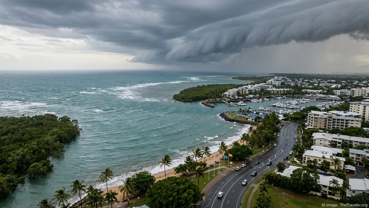
Australia’s tropical north is on heightened alert as Tropical Cyclone Narelle intensifies in the Coral Sea, with forecast guidance indicating a rapid escalation to a severe Category 4 system and mounting risks of widespread travel disruption in the days ahead.
Get the latest news straight to your inbox!
Cyclone Narelle Strengthens in Coral Sea With Category 4 Fears
Forecast tracks from international and Australian meteorological agencies on March 18 indicate that Tropical Cyclone Narelle, currently over the warm waters of the northern Coral Sea, is entering a phase of rapid intensification. Publicly available bulletins describe a powerful system with strong core winds and deep convection, moving steadily toward the Queensland coast under highly favorable ocean and atmospheric conditions.
Outlook charts suggest Narelle is likely to reach or approach Category 4 intensity on the Australian scale before or near its first land interaction, with some guidance pointing to a further window for strengthening as it nears Far North Queensland. The combination of very warm sea surface temperatures, abundant moisture and relatively low wind shear is being cited as a key driver behind expectations for what observers describe as potentially explosive intensification.
As of Wednesday, model consensus continues to focus on a track toward the Cape York Peninsula and Far North Queensland coastline late this week, before the system is projected to cross into the Gulf of Carpentaria. From there, medium-range guidance suggests Narelle could restrengthen over the Gulf and ultimately bring severe weather westward toward Australia’s Top End over the weekend.
Although exact landfall timing, location and peak intensity remain uncertain, the trend toward a stronger cyclone close to densely visited coastal areas has prompted heightened concern in the travel and tourism sector, particularly around Cairns, Port Douglas and the broader Great Barrier Reef gateway region.
Flight Schedules Under Strain as Airlines Prepare for Disruptions
Major domestic and regional carriers serving northern Queensland are beginning to adjust operations as Narelle’s projected path narrows. According to published airline advisories and airport notices, carriers are preparing for rolling schedule changes, including the potential for same-day cancellations into and out of Cairns, Townsville and smaller regional airports along the Far North Queensland coast as conditions deteriorate.
Advance planning typically includes repositioning aircraft away from the cyclone’s projected impact zone, consolidating services on earlier flights, and issuing flexible rebooking options for passengers holding tickets during the forecast window of severe weather. Publicly available information from previous cyclone seasons in Queensland shows that airlines often pre-emptively suspend operations at exposed airports once strong winds and heavy rain are imminent, both for safety and to avoid aircraft being stranded.
Travelers with upcoming itineraries into Cairns, the Daintree region or Cape York are being urged in public travel forums and advisory pages to closely monitor airline updates, opt in for real-time alerts and consider moving flights forward or delaying non-essential journeys. Industry observers note that even locations south of the forecast landfall zone, such as the Whitsundays and Mackay, may see knock-on schedule changes as fleets and crews are reshuffled.
Airports themselves are preparing for possible closures of runways and exposed facilities should gale-force winds and intense rain bands move ashore. Past experience with systems such as Cyclone Alfred and Cyclone Koji has shown that even short-lived closures can trigger multi-day disruption for domestic and international travelers connecting through Australia’s eastern hubs.
Cruise Itineraries and Reef Excursions Face Widespread Revisions
The marine tourism sector is also bracing for major disruption, with cruise operators and reef excursion companies widely expected to reroute or cancel sailings as Narelle approaches. Publicly available cruise tracking and advisory data indicate that lines operating along Australia’s east coast typically divert ships well away from projected cyclone paths, leading to port cancellations in Cairns, Port Douglas and nearby tender ports when strong systems threaten.
For international voyages transiting between the South Pacific and Southeast Asia, itinerary changes can include skipping calls in northern Queensland altogether, substituting ports further south, or extending sea days until conditions improve. This often has a domino effect on shore-based businesses, from reef tour operators and dive boats to waterfront restaurants and hotels that rely on the daily arrival of cruise passengers.
Locally based reef and island cruise companies serving the Great Barrier Reef are likely to suspend operations once winds and swell increase, prioritizing vessel safety and avoiding damage at exposed marinas and moorings. Published guidance from maritime authorities and past cyclone events in the region highlights that even after the core of a cyclone passes, lingering high seas, strong currents and turbid water can delay the safe resumption of snorkeling and diving trips.
Travelers already in coastal resorts are being advised through public channels to stay in contact with their accommodation providers and tour desks for the latest updates on reef trips, island transfers and coastal cruises, as operators may adjust departure times or cancel on short notice in response to changing forecasts.
Tourism Hotspots Activate Preparedness Plans Across Northern Australia
From Cairns and Palm Cove to more remote communities along the Cape York Peninsula, tourism-reliant towns are activating seasonal cyclone plans tailored to both residents and visitors. Publicly accessible local council information outlines measures such as securing waterfront promenades, clearing loose debris, reviewing evacuation routes and ensuring backup power arrangements for key services including hospitals, accommodation facilities and airports.
Accommodation providers in Far North Queensland commonly adopt structured cyclone checklists during high-risk periods, including reinforcing outdoor fixtures, moving furniture indoors, checking emergency lighting and stocking essential supplies. Travelers may notice on-site preparations increasing as Narelle draws closer, with resort staff temporarily closing pools, beach access points and exposed rooftop bars or viewing decks.
The current forecast scenario, which indicates that Narelle could cross Cape York before emerging into the Gulf of Carpentaria and tracking toward the Northern Territory, has also caught the attention of tourism operators in Darwin and across the Top End. Public weather outlooks suggest bands of heavy rain, coastal flooding and strong winds could extend across a wide area, affecting road conditions on popular driving routes and potentially leading to temporary closures of nature-based attractions.
Observers note that recent seasons have already challenged northern Australia’s tourism industry with a combination of heavy rainfall events and tropical systems. This has led many operators to refine contingency plans, from flexible booking policies to backup excursions that are less exposed to weather, such as indoor cultural experiences and urban attractions.
What Travelers Should Do Now as Narelle Threatens to Intensify
With forecast confidence growing that Narelle will remain a significant cyclone as it nears land and possibly intensifies toward Category 4, travel experts and public advisory platforms are emphasizing early action for anyone planning to visit or transit through northern Queensland and the Top End in the coming days. This includes confirming accommodation bookings, checking cancellation policies, and reviewing travel insurance coverage for weather-related disruption.
It is recommended that travelers monitor official weather updates, airline and cruise notices, and accommodation communications at least daily, and more frequently as the projected impact window narrows. Publicly available information on previous cyclone impacts in Australia shows that local conditions can change rapidly, with roads, airports and ports shifting from normal operations to restricted or closed within a matter of hours once severe weather arrives.
Those already in the region are being encouraged through public channels to follow local advice regarding safe shelter, avoid unnecessary coastal travel once warnings escalate, and build extra time into any overland journeys to account for road closures or flooding. Visitors planning road trips between Queensland and the Northern Territory, or into remote parts of Cape York, may need to consider alternative routing or postponement until the system has passed and road conditions are reassessed.
As Tropical Cyclone Narelle continues to evolve over the Coral Sea, its expected intensification and complex, cross-continent track place Australia’s northern travel corridor under sustained pressure. The coming days are set to be critical for residents, tourism operators and travelers alike as they navigate a fast-changing situation shaped by one of the most closely watched cyclones of the 2025–26 Australian season.