
Vatnajökull National Park covers a huge portion of eastern and central Iceland, wrapping its vast ice cap around volcanic peaks, tumbling outlet glaciers and dramatic coastlines. For travelers, this can feel both exciting and overwhelming: with so much ground to cover, knowing where to focus your limited time becomes essential. The park is divided into distinct regions, each with its own character, access points and standout experiences, from gentle hikes to raw, backcountry adventures. This guide highlights the best areas to explore, helping you match Vatnajökull’s wild landscapes with your interests, season and comfort level.
Skaftafell: Classic Trails Beneath the Ice Cap
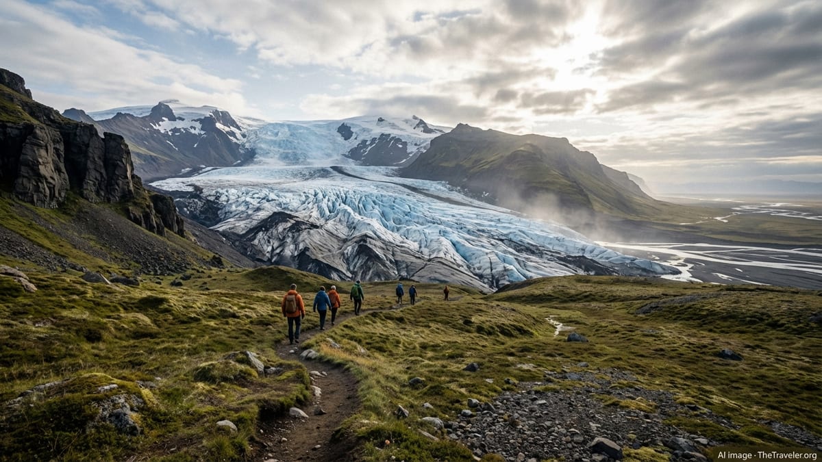
Skaftafell is the most accessible and developed corner of Vatnajökull National Park, set along Iceland’s Ring Road in the southeast. Once a stand‑alone nature reserve, it is now a key gateway to glacier country, with a visitor center, marked paths and services that make it an ideal base for first‑time visitors. The scenery is a striking mix of birch scrub, black sand outwash plains and gleaming outlet glaciers spilling down from the ice cap above.
Most visitors come to Skaftafell for its hiking, which caters to a wide range of abilities. Well‑maintained trails fan out from the main parking area, leading to viewpoints over the Skaftafellsjökull glacier tongue, gentle valley walks and more demanding routes into the high heath. The infrastructure and clear signage mean you can explore independently in good conditions, while guided tours are available if you want to venture onto the ice itself with specialist equipment and a qualified guide.
One of Skaftafell’s headline attractions is Svartifoss, the “black waterfall” framed by dark hexagonal basalt columns that resemble an enormous pipe organ. The walk to the falls takes roughly one to two hours round trip for most visitors, climbing steadily from the visitor center across open slopes dotted with dwarf birch. The reward is a compact natural amphitheater where white water plunges over geometric rock, a scene that has inspired modern Icelandic architecture. Arriving early or late in the day can make the experience feel more tranquil, especially in summer.
Beyond Svartifoss, Skaftafell offers routes with fewer crowds and bigger views. The Sjónarnípa viewpoint, reached on a moderate half‑day loop, offers a sweeping panorama straight down the Skaftafellsjökull glacier tongue and across the sandur plains toward the Atlantic. Stronger hikers can continue farther into Morsárdalur, a long glacial valley where braided rivers, distant icefalls and broad gravel flats create a powerful sense of scale. Even short walks here give a taste of Vatnajökull’s energy, but the weather shifts quickly, so layered clothing and a flexible plan are important.
Jökulsárlón & The Glacier Lagoons
East of Skaftafell, the landscape opens into a series of glacier lagoons where outlet glaciers meet lowland plains. The most famous of these is Jökulsárlón, a broad, deep lake filled with icebergs that have calved from the Breiðamerkurjökull glacier. The result is a constantly changing mosaic of blue and white ice blocks drifting silently past, some streaked with volcanic ash and others polished to a translucent sheen. Even from the roadside parking area, the view feels otherworldly, especially under shifting Icelandic light.
On the seaward side of the road lies the stretch of black sand commonly called Diamond Beach, where chunks of ice from the lagoon wash ashore and glint in the sun. Walking along this shoreline is an easy way to experience the contrast of dark volcanic sand and crystal ice, and it remains accessible in most seasons, though storms and tides can reshape the beach almost daily. Visitors should keep a respectful distance from the surf, as waves can be stronger and more unpredictable than they appear from afar.
For a closer look at the icebergs and glacier faces, seasonal boat and zodiac tours operate on Jökulsárlón and nearby lagoons such as Fjallsárlón and Heinabergslón. These trips typically run from late spring into autumn, adjusting start and end dates based on ice and weather conditions each year. On calm days, low‑angled light reflects off still water and ice surfaces, creating a serene atmosphere. Guides tend to emphasize safety and environmental awareness, explaining how the lagoons are shaped by retreating glaciers and ongoing climate change.
This area is also a launch point for guided glacier walks and, in the colder months, tours into natural ice caves that form beneath the ice cap. Access to these caves is highly seasonal and depends on safety assessments made locally each year, so it is essential to rely on reputable operators who monitor conditions closely. Whether you explore from the shoreline or join a guided excursion, the lagoons offer one of the most immediate and photogenic encounters with Vatnajökull’s ice.
Jökulsárgljúfur: Canyons, Waterfalls and Volcanic Cliffs
On the park’s northern side, the Jökulsárgljúfur area presents a very different face of Vatnajökull. Here, the Jökulsá á Fjöllum river has carved a deep, rugged canyon system, flanked by cliffs, rock formations and large waterfalls. The most famous of these is Dettifoss, often described as one of Europe’s most powerful waterfalls, where glacial meltwater surges over a broad horseshoe drop into a mist‑filled chasm. The rumble of water and persistent spray create an intense sensory experience, especially at close viewpoints.
Trails from parking areas on both sides of the canyon lead to multiple viewpoints over Dettifoss and the smaller falls of Selfoss and Hafragilsfoss, each offering different angles and distances. While access roads are generally improved and signposted, seasonal closures or restrictions can occur due to snow, ice or rockfall risk. Recent years have seen occasional landslides in the broader Dettifoss region, reminding visitors that this is a dynamic, evolving landscape where conditions must be checked before travel, particularly outside the main summer season.
Away from the main waterfall viewpoints, Jökulsárgljúfur invites exploration of volcanic and erosion‑sculpted terrain. The horseshoe‑shaped basin of Ásbyrgi, with its sheer cliffs and sheltered woodland, feels like a natural amphitheater and has easy, family‑friendly trails. Farther south, the remains of older catastrophic flood events can be seen in jagged rock formations and scoured canyon walls. Spending a full day in this area allows time to combine short walks to viewpoints with a longer hike along sections of the canyon rim, always keeping well back from unprotected edges.
Because Jökulsárgljúfur is more remote than the southeast coast, services and facilities are more spread out, and some roads are gravel rather than paved. Visitors who value quieter trails and broad, open vistas tend to find this region especially rewarding. Late spring through early autumn is the most practical season for independent travel here, with longer daylight hours and more predictable road conditions, though weather can still change abruptly.
Remote Highlands: Askja, Eldgjá and Langisjór
Beyond the more accessible glacier fronts and canyon viewpoints lie Vatnajökull’s highland regions, where the combination of volcanic activity and glacial influence is starkly apparent. Places such as Askja, Eldgjá and the Langisjór area offer some of the most remote and rugged experiences in Iceland, typically reachable only via highland roads that open in summer and require suitable vehicles and experience to navigate safely. These areas attract travelers who are comfortable with limited services, variable track conditions and a strong emphasis on self‑reliance.
Askja is a volcanic caldera complex in the central highlands, surrounded by black lava deserts and ridges of rhyolite and basalt. In the short summer window when access tracks are open, visitors can hike to views over the main caldera lake and the smaller, geothermal crater lake Víti. Snow patches often linger on the surrounding slopes even in mid‑season, and the weather at this altitude can be markedly colder and more changeable than on the coast. Because of the delicate geothermal environment and potential hazards, it is important to stay on marked paths and heed local guidance about safe vantage points.
To the south, Eldgjá is a vast volcanic fissure system associated with one of the largest known historical eruptions in Iceland. Today it is a dramatic canyon with steep walls and a notable waterfall, accessible via highland routes that usually open during the drier months. Trails in this area pass through a mix of mossy lava, pumice slopes and river valleys, offering views that tie present‑day landscapes to deep geological events. Weather and river levels can affect route choices, so many visitors opt to join guided highland excursions that include Eldgjá as part of a longer itinerary.
Langisjór, a long, narrow highland lake framed by ridges and lava fields, rounds out this trio of remarkable but remote landscapes. Its shoreline and nearby hills provide quieter hiking compared with more famous areas closer to the Ring Road, and the stark contrast between clear water and dark volcanic ground creates a distinctive atmosphere. Reaching Langisjór generally involves rough tracks and fords that are unsuitable for standard rental cars, which means planning, checking current road information and, when in doubt, traveling with experienced drivers or organized tours.
Hidden Canyons and Lesser‑Known Valleys
Between the major glacier fronts and well‑publicized waterfalls, Vatnajökull National Park shelters smaller canyons and valleys that feel surprisingly wild, even when they are not far from the main highway. One such place is Múlagljúfur, a steep, verdant canyon in the southeast that remains less visited than nearby Jökulsárlón. A rough access track and unmarked junctions can make the trailhead slightly confusing for first‑time visitors, but those who find their way are rewarded with a balcony‑like viewpoint over deep chasms, hanging waterfalls and glacially carved peaks.
The hike into Múlagljúfur is relatively short but involves uneven, sometimes narrow paths along slopes that drop steeply toward the canyon. In dry summer conditions, hikers with good footwear and a head for heights often describe it as moderately demanding rather than technically difficult. The views from the upper vantage points feel unexpectedly expansive, with waterfalls like Hangandifoss and Múlafoss cutting through the cliffs below, and glacier tongues visible in the distance. Because this is not a fully serviced site, visitors need to be especially careful with route‑finding, staying on established trods and keeping a safe distance from unstable edges.
Elsewhere around the park, side valleys such as Morsárdalur near Skaftafell offer quieter alternatives to headline trails. In Morsárdalur, long day hikes or overnight treks traverse broad glacial valleys where braided rivers, patches of birch woodland and distant icefalls create a sense of vastness. These routes typically suit fit, experienced hikers who are comfortable with longer distances, occasional river crossings and limited shelter. Weather windows, daylight hours and river levels are key considerations when planning any extended valley hike in Vatnajökull.
Because these canyons and valleys have seen rising interest in recent years without the same level of infrastructure as more established sites, visitors can help protect them by practicing low‑impact travel. That means sticking to existing paths, packing out all litter and resisting the temptation to venture onto unstable slopes or cliff edges for photographs. With thoughtful behavior, it is possible to enjoy the thrill of discovery while supporting the park’s long‑term conservation goals.
On the Ice: Glaciers, Ice Caves and Safety
At the heart of Vatnajökull National Park lies its defining feature: the Vatnajökull ice cap itself, one of the largest in Europe by volume. From its high, gently domed interior, numerous outlet glaciers flow outward through valleys toward the lowlands, creating the icy tongues visible from Skaftafell, the glacier lagoons and various viewpoints around the park. For many travelers, standing at the edge of one of these glaciers, or carefully stepping onto the ice with a guide, is the highlight of their visit.
Guided glacier walks depart from hubs such as Skaftafell and the Jökulsárlón region, supplying crampons, ice axes, helmets and other safety equipment as needed. Routes change over time as crevasses open, snow bridges collapse and melt patterns shift, so guides constantly adjust the exact paths they take. A typical excursion might involve hiking over rough moraine before stepping onto gently inclined ice, where visitors can peer into small crevasses, observe blue ice strata and feel the subtle movement of the glacier beneath their feet. Group sizes, age limits and fitness expectations vary by operator and season.
In winter and the colder shoulder seasons, conditions occasionally allow access to natural ice caves that form where meltwater and air carve tunnels beneath or within the glacier. These caves are inherently temporary, often changing from one year to the next and sometimes within a single season. Professional guides assess their stability, monitor weather and temperature trends, and decide when it is safe to enter. Visitors should expect that tours may be rerouted, shortened or canceled if conditions are not suitable; this flexibility is a central part of staying safe in such an environment.
Independent travel on glaciers without proper training, equipment and local knowledge is strongly discouraged. Crevasses, moulins and unstable seracs can be hidden beneath snow or disguised by surface patterns, and the consequences of a misstep can be severe. Even when simply walking close to a glacier tongue or along lagoon shores, it is important to respect safety boundaries, avoid standing on overhanging ice and stay well back from calving fronts where ice can break suddenly. By treating the ice cap as a living, shifting landscape rather than a static backdrop, visitors can enjoy Vatnajökull’s most dramatic feature with appropriate caution.
Planning Your Visit: Seasons, Access and Practical Tips
Because Vatnajökull National Park spans such a large area and a wide range of elevations, planning a visit begins with understanding Iceland’s seasons and regional differences. Summer, typically June through August, offers the broadest access, with highland tracks opening, long daylight hours and a fuller range of tours and services. This is also when the most popular areas are busiest, so those seeking quieter experiences might favor early mornings, late evenings or the shoulder months of May and September, accepting a greater chance of unsettled weather.
Winter, from roughly November to March, transforms much of the park into a snowy, icy landscape where short days, storms and limited road access shape what is realistic. In these months, travel focuses on lower‑elevation areas along the south coast and selected parts of the north, with guided glacier walks, ice cave tours and aurora watching as key draws. Road conditions can change rapidly, so visitors should check up‑to‑date travel advisories, weather forecasts and park announcements before driving, and allow extra time for delays or detours.
Across all seasons, it is wise to consider Vatnajökull’s main regions as separate trip segments rather than a single destination to “cover” quickly. Skaftafell and the glacier lagoons make a natural pairing on a multi‑day journey along the south coast. Jökulsárgljúfur and the northern canyons fit easily into a broader circuit of North Iceland. The highlands around Askja, Eldgjá and Langisjór generally require dedicated planning, often with specialized vehicles or organized tours that can adjust to river levels and track conditions. Visitor centers positioned around the park provide current information, exhibits and, in some seasons, ranger‑led activities.
Simple preparations can significantly improve the experience. Layered clothing, including waterproof outerwear, is important even in summer, as wind and rain can arrive with little warning. Sturdy footwear with good grip makes trails safer and more enjoyable, particularly on wet, rocky or uneven ground. A flexible itinerary that allows for weather‑related changes, coupled with realistic driving distances and rest breaks, helps keep a Vatnajökull adventure rewarding rather than rushed. Respecting signed closures, staying on marked paths and following local guidance about sensitive areas all support the park’s efforts to balance access with conservation.
The Takeaway
Vatnajökull National Park is not a single viewpoint or roadside stop but a mosaic of distinct landscapes, each revealing a different aspect of Iceland’s relationship with ice and fire. Skaftafell offers approachable trail networks and iconic sights like Svartifoss and Sjónarnípa, making it an ideal starting point for many travelers. The glacier lagoons around Jökulsárlón provide intimate contact with drifting icebergs and the spectacle of calving glacier tongues, while Jökulsárgljúfur showcases the erosive power of glacial rivers through canyons, cliffs and thunderous waterfalls.
For those willing to venture farther, the highlands around Askja, Eldgjá and Langisjór deliver a sense of remoteness that is increasingly rare, where weather, track conditions and time all demand respect. Hidden canyons and quieter valleys, from Múlagljúfur to Morsárdalur, reward patient exploration and careful route‑finding, offering powerful experiences away from busy viewpoints. Across all these areas, guided glacier and ice cave excursions open a window onto the interior of the ice cap, provided visitors treat safety advice as non‑negotiable.
Ultimately, the best areas to explore in Vatnajökull National Park depend on your time, season, interests and appetite for adventure. By focusing on a few key regions rather than trying to see everything at once, and by staying flexible in the face of Iceland’s changeable weather, you can experience the park in a way that feels both immersive and manageable. Whether you leave with memories of basalt‑framed waterfalls, iceberg‑strewn shorelines, roaring canyons or silent highland plateaus, Vatnajökull has a way of lingering long after the journey home.
FAQ
Q1. What is the easiest area of Vatnajökull National Park for first‑time visitors?
The Skaftafell area on the south side of the park is usually the easiest for first‑time visitors, thanks to its clear trail network, visitor center, services and proximity to the Ring Road.
Q2. When is the best time of year to visit Vatnajökull National Park?
Summer from June to August offers the widest access and longest days, while late spring and early autumn provide fewer crowds. Winter visits are also possible in selected areas but require more flexibility and preparation.
Q3. Do I need a guided tour to go on Vatnajökull’s glaciers?
Yes, for safety reasons travel onto the glacier surface should be done with certified guides who provide equipment and choose routes that reflect current conditions on the ice.
Q4. Can I see ice caves all year round?
No, natural ice caves are highly seasonal and their availability changes each year. They are typically visited in the colder months when conditions are stable enough, and tours may be canceled or rerouted if safety is in question.
Q5. Is it possible to visit both Jökulsárlón and Skaftafell in one day?
They can be visited in one day as they are within a reasonable driving distance of each other, but many travelers prefer to stay nearby and spread their time over at least two days to avoid rushing.
Q6. Are there easy hikes suitable for families?
Yes, Skaftafell offers several short, well‑marked trails to viewpoints and glacier edges that many families enjoy, and Ásbyrgi in the Jökulsárgljúfur area has gentle woodland paths and accessible viewpoints.
Q7. Do I need a 4x4 vehicle to explore the park?
For main sites along the Ring Road, a standard car usually suffices in good conditions. Reaching highland areas such as Askja, Eldgjá and Langisjór generally requires a suitable 4x4 and experience with Icelandic highland roads, or joining a guided tour.
Q8. How many days should I plan for Vatnajökull National Park?
A minimum of two to three days allows time to see Skaftafell and the glacier lagoons at a relaxed pace. Adding the northern canyons or highland regions calls for additional days within a longer Iceland itinerary.
Q9. Is wild camping allowed inside the park?
Camping rules vary by area and are subject to regulations designed to protect nature. In most cases it is best to use designated campsites or follow current guidance from park authorities and local information centers.
Q10. How can I minimize my impact while visiting Vatnajökull?
You can minimize impact by staying on marked paths, respecting closures, carrying out all litter, avoiding fragile mossy areas and following local safety and conservation advice from rangers and guides.