
More news on this day
A powerful nor’easter is bearing down on New York and the wider Tri-State area, with forecasters warning of a potentially historic blizzard bringing life-threatening snow, fierce winds and hazardous travel from Sunday into Monday.
First Blizzard Warning in Nearly a Decade
The National Weather Service has issued a rare blizzard warning for New York City, Long Island, southern Connecticut and parts of New Jersey, the first such alert for the region since 2017. The rapidly intensifying storm is expected to organize off the Mid-Atlantic coast on Sunday, then track northward, locking the densely populated Interstate 95 corridor under a band of intense snow and punishing winds.
Forecast models now widely agree that the nor’easter will be one of the strongest snow events of recent years for the metropolitan region. Meteorologists say confidence in a high-impact storm surged over the past 24 hours as the system’s projected track shifted closer to the shoreline, placing New York and surrounding communities directly in the bull’s-eye.
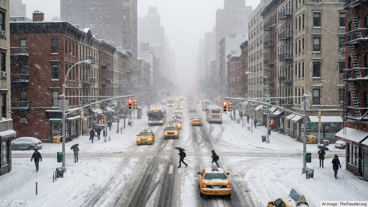
Blizzard conditions are defined by sustained winds or frequent gusts of at least 35 miles per hour, coupled with falling or blowing snow that reduces visibility to a quarter-mile or less for at least three consecutive hours. Officials caution that even experienced winter drivers may find travel “dangerous, if not impossible” during the height of the storm.
Heavy Snowfall and Whiteout Risk Across the Region
Snow is expected to begin across the New York City area on Sunday morning or midday, likely mixing with rain near the coast initially before colder air locks in. By Sunday evening, forecasters anticipate a rapid intensification, with snowfall rates climbing to 1 to 2 inches per hour and potentially higher in localized bands overnight.
Across the five boroughs, current projections call for 13 to 18 inches of accumulation, with the possibility of totals topping 20 inches where the most persistent snow bands set up. Long Island, coastal New Jersey and parts of southern Connecticut are poised for some of the highest amounts, with forecasters warning that subtle shifts in the storm track could still nudge final totals up or down.
North and west of the city, including interior New Jersey, the Hudson Valley and inland Connecticut, totals are expected to be somewhat lower but still significant, generally in the 5 to 10 inch range. Even in these areas, bursts of heavy snow and blowing drifts could create brief whiteout conditions, especially overnight Sunday into the Monday morning commute.
Travelers are being urged to complete any essential journeys by late Saturday or very early Sunday. Transportation agencies warn that once the heaviest snow and wind arrive, plows may struggle to keep up and visibility will collapse, making even short drives treacherous.
Damaging Winds and Widespread Power Outage Threat
Compounding the snow hazard will be strong, gusty winds as the storm deepens off the coast. Forecasts call for sustained winds of 25 to 35 miles per hour, with gusts frequently reaching 45 to 55 miles per hour across much of the Tri-State area, and locally higher along exposed shorelines and barrier islands.
Those wind speeds, combined with heavy, wetter snow expected along the immediate coast, heighten the risk of tree damage and downed power lines. Utilities across New York, New Jersey and Connecticut have activated storm response plans, staging additional crews and equipment near anticipated trouble spots in an effort to restore electricity quickly where outages occur.
Residents are being advised to prepare for the possibility of losing power for extended periods, particularly in communities with above-ground lines. Officials recommend charging phones and essential devices in advance, having flashlights and batteries on hand, and avoiding the use of candles, which can pose a fire risk. Those who rely on electrically powered medical equipment are being encouraged to confirm backup power sources or alternate care arrangements.
Wind chills will add another layer of danger, especially overnight. With temperatures dropping into the 20s and strong gusts, apparent temperatures will feel closer to the single digits in some locations, increasing the risk of frostbite and hypothermia for anyone stranded outdoors or without adequate heat.
Coastal Flooding Concerns Along New York and New Jersey Shores
While heavy snow will dominate inland headlines, coastal flooding is emerging as a significant secondary threat for shoreline communities from the Rockaways and southern Queens to Long Island’s South Shore, New York Harbor, the Jersey Shore and parts of coastal Connecticut. The powerful onshore winds and low atmospheric pressure associated with the nor’easter are expected to push water levels above normal during several tidal cycles.
Coastal flood watches and warnings are in effect for vulnerable bays, inlets and back-bay areas, where forecasters anticipate minor to locally moderate flooding. Inundation of 1.5 to 3 feet above ground level is possible in some low-lying neighborhoods, which could flood roadways, parking lots and ground-level structures, particularly during high tide late Sunday night and early Monday.
Officials warn that flooding may be obscured by falling and blowing snow, making it difficult for drivers to gauge water depth and roadway hazards. Residents in at-risk zones are being urged to move vehicles to higher ground, avoid parking in waterfront lots and secure outdoor items that could be swept away by rising water or high waves.
In addition to flooding, pounding surf and strong winds may cause beach erosion and damage to dunes and coastal infrastructure. Emergency managers are closely watching vulnerable stretches of shoreline that were already stressed by earlier winter storms this season.
States of Emergency and Travel Disruptions
In anticipation of the storm’s impact, state and local leaders across the Tri-State area are moving swiftly to mobilize resources and discourage nonessential travel. New York Governor Kathy Hochul has declared a state of emergency for more than 20 counties, unlocking additional funding and allowing for faster deployment of equipment and personnel to the hardest-hit communities.
New York City officials say hundreds of salt spreaders and snowplows are being prepositioned on major arteries, bridges and bus routes, supported by contracted equipment to bolster city fleets. Similar preparations are under way in New Jersey and Connecticut, where state transportation departments are coordinating with local agencies to prioritize highways, commuter corridors and emergency access routes.
Major airports serving the region, including John F. Kennedy, LaGuardia and Newark Liberty, are warning travelers to expect extensive delays and cancellations beginning Sunday and potentially rippling into Monday and Tuesday. Airlines have already begun issuing travel waivers, allowing customers to rebook flights without change fees ahead of the storm.
Rail and bus services are also bracing for disruption. Commuter rail operators and regional bus carriers say schedules may be reduced or suspended if conditions deteriorate, particularly if drifting snow blocks tracks or major roadways. Travelers are being urged to monitor carriers’ alerts and avoid last-minute trips as the storm peaks.
New York City Braces: Schools, Shelters and Street-Level Impacts
Within New York City, officials are focused on safeguarding some 8.5 million residents through what could be the biggest winter storm in nearly a decade. The city’s Emergency Management department has activated its situation room and is coordinating with police, fire, sanitation, transit and health agencies to monitor conditions and adjust operations in real time.
Mayor Zohran Mamdani has urged New Yorkers to stay off the roads once snow intensifies and to use public transit only if absolutely necessary. The city is weighing decisions on school closures and remote learning for Monday, with an announcement expected as confidence in the timing and intensity of the storm solidifies. Families are being told to prepare for the possibility of children remaining home.
Attention is also turning to the city’s most vulnerable residents, including those without stable housing. Outreach teams are expanding efforts to bring people indoors ahead of the worst weather, with additional shelter capacity and warming centers set to open. After a deadly cold snap earlier this winter, city leaders say they are determined to reduce exposure risks as frigid temperatures and heavy snow converge.
At street level, residents are stocking up on groceries, medications and essential supplies in anticipation of being homebound for at least 24 to 36 hours. Corner stores and supermarkets reported brisk business on Saturday, while hardware shops saw surging demand for shovels, ice melt and snow brushes.
Advice for Travelers and Visitors to the Tri-State Area
For travelers and visitors currently in or headed to the New York metropolitan region, the message from authorities is clear: adjust plans now. Tourism officials and travel providers are advising nonessential visitors to consider postponing trips, particularly leisure travel scheduled for Sunday and Monday, when conditions will be at their worst.
Those already in the area are being urged to shelter in place once snow and wind intensify, and to avoid driving unless it is an emergency. Visitors staying in hotels are encouraged to confirm meal service options on-site, as many restaurants and attractions are likely to close or operate on reduced hours during the storm. Hotel staff can also provide updates on local conditions and public transit status.
For travelers who must be on the move, safety experts recommend assembling a winter emergency kit that includes warm clothing, blankets, water, nonperishable snacks, a flashlight, a charged phone and a portable power bank. Drivers should keep fuel tanks at least half full, clear snow from all windows, lights and roofs, and avoid back roads that may be plowed less frequently.
International visitors unfamiliar with northeastern U.S. winter storms are being reminded that blizzard conditions can change rapidly. A street that appears passable one moment can become impassable minutes later due to drifting snow and falling visibility. Officials stress that heeding local advisories and erring on the side of caution is essential.
What Comes After the Storm
While the worst of the storm is expected to taper off by Monday afternoon, the region will not snap back to normal immediately. Snow removal will be a multi-day effort, especially in outer borough neighborhoods and suburban communities with extensive side streets and cul-de-sacs.
Forecasters expect temperatures to gradually moderate into the upper 30s and 40s by the middle of next week, offering some natural melting. However, the combination of plowed snowbanks, lingering ice and refreezing overnight could keep sidewalks and intersections slippery, particularly in shaded areas.
Transportation networks may also face lingering disruptions. Airlines warn that aircraft and crew displacement could lead to continued cancellations and delays even after skies clear. Commuter rail lines and subway systems will need time to address snow and ice buildup, with some above-ground sections more vulnerable to weather-related slowdowns.
Despite the challenges, officials emphasize that advanced warning and extensive preparations should help the region weather the storm more safely. Residents and visitors who stay informed, limit travel and take basic precautions, they say, will play a crucial role in reducing injuries and easing the strain on emergency responders as the blizzard sweeps across New York and the Tri-State area.