
More news on this day
A rapidly deepening bomb cyclone has unleashed a blizzard across New York and the broader Northeast on Monday, paralyzing travel, cutting power to hundreds of thousands of customers and prompting officials to warn that the storm could rank among the most severe snow events to hit the region in more than a century.
Snowfall Records Fall as City Is Swallowed in White
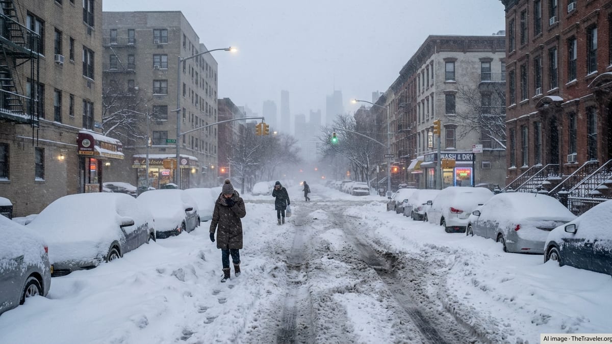
By Monday afternoon, snow totals across the New York metropolitan area had surged well past a foot, with parts of Long Island and central New Jersey buried under more than 20 inches. In Central Park, measurements surpassed 15 inches, already making this New York City’s heaviest snowstorm in at least five years and one of the most intense single-day events in recent memory. Snow bands pivoting in from the Atlantic piled on additional accumulations at rates of 2 to 3 inches per hour, periodically reducing visibility to near zero.
Communities on Long Island reported some of the region’s highest totals, with locations such as Islip recording over 22 inches by midday. In New Jersey, towns including Freehold and other interior communities tallied similar amounts, transforming streetscapes into towering canyons of snow. Farther north and east, parts of Connecticut, Rhode Island and coastal Massachusetts climbed toward or beyond the two-foot mark, with some neighborhoods in New England bracing for totals of 30 inches as the system continued its slow march up the coast.
The scale and rapidity of accumulation have little precedent in recent decades for major East Coast cities. Weather historians noted that while exact rankings will depend on final measurements and post-storm analysis, the combination of snowfall, wind and duration may place this event alongside legendary blizzards of the late 19th and early 20th centuries, fueling city officials’ warnings that New York is confronting one of its most severe snowstorms in roughly 150 years.
Even as the heaviest bands begin to pivot toward New England, forecasters caution that blowing and drifting snow will keep totals in flux in the hours ahead. Plow crews across the five boroughs and surrounding counties struggled to keep up as snow filled in behind them almost as fast as it could be cleared, leaving many smaller side streets completely impassable.
Bomb Cyclone Dynamics Turn Nor’easter into a Beast
Meteorologists classify the storm as a classic nor’easter that has undergone a process known as bombogenesis, the rapid intensification that turns a strong coastal low into what is commonly called a bomb cyclone. In this case, the storm’s central pressure plunged roughly 40 millibars in 24 hours as it tracked northward just off the Eastern Seaboard, an atmospheric freefall that easily meets the technical threshold for a bomb cyclone.
The intensifying low pressure system tapped into sharp temperature contrasts between frigid Arctic air pouring out of Canada and comparatively mild ocean waters of the western Atlantic. That clash fueled powerful uplift and moisture transport, helping build the expansive shield of heavy snow now draped from the Mid-Atlantic to Maine. Embedded within that shield, narrow but ferocious snow bands have been responsible for the highest accumulation rates and the most dangerous whiteout conditions.
As the storm deepened offshore, winds ramped up dramatically, particularly along the coast. Gusts of 60 to more than 80 miles per hour were recorded from Long Island to Cape Cod, turning ordinary snow showers into a full-scale blizzard. In New York City, gusts above 50 miles per hour blasted down avenues and across bridges, driving fine snow into every crevice and turning sidewalks into shifting dunes.
Forecasters at the National Weather Service and private outlets such as The Weather Channel and AccuWeather stressed that the combination of rapid pressure falls, strong winds and heavy snow made this system especially dangerous. Even locations accustomed to winter storms have been urged to treat this event as exceptional, with warnings that travel could be life-threatening and that visibility might abruptly drop to near zero in a matter of seconds.
Travel Bans, Flight Cancellations and a Region at a Standstill
As the storm intensified overnight, officials up and down the Northeast corridor moved swiftly to shut down nonessential travel. In New York City, Mayor Zohran Mamdani declared a state of emergency and imposed a ban on most vehicular traffic on city streets through at least midday Monday, carving out limited exceptions for emergency services and essential workers. Police checkpoints and electronic message boards reminded drivers that violation of the restrictions could bring hefty fines.
Major highways across the region were subject to a patchwork of restrictions. Portions of the New York State Thruway, the Long Island Expressway and key New Jersey routes were closed to trucks and other commercial vehicles, with some stretches temporarily off limits to all traffic as whiteout conditions developed. New Jersey Transit suspended bus service and light rail on Sunday night, while the Long Island Rail Road halted operations as drifting snow overwhelmed tracks and switches. Subways in New York continued to run but with significant delays and suspensions on elevated lines in the outer boroughs.
Aviation fared little better. Airlines canceled thousands of flights scheduled for Sunday and Monday, effectively shutting down air travel at New York’s three major airports and severely curtailing operations in Boston, Philadelphia and other regional hubs. Passengers who had not already rebooked found themselves stranded in terminals or forced to scrap travel plans entirely. Airlines began waiving change fees several days before the storm, but the sheer number of cancellations left many travelers looking at rebookings days into the future.
Ride-hailing services and intercity bus operators also largely suspended service, leaving roads eerily quiet except for plows, ambulances and the occasional stranded motorist. For tourists in New York and Boston, the stoppage turned bustling streets into snow-cloaked pedestrian zones, where the only sounds were the crunch of boots and the distant rumble of plow blades scraping asphalt.
States of Emergency and Coastal Concerns
The governors of New York, New Jersey, Connecticut, Rhode Island and Massachusetts all issued states of emergency in advance of the storm, unlocking additional funding and enabling the rapid deployment of National Guard troops, utility repair crews and search and rescue teams. In New York, more than a hundred Guard members were pre-positioned to assist with stranded motorists, medical transport and storm damage assessments.
Along the shoreline from the Jersey Shore through Long Island and up into coastal New England, officials were equally concerned about the threat of coastal flooding. The storm’s intense low pressure and powerful onshore winds have combined to push water toward the coastline, raising the risk of storm surge on top of high astronomical tides. Low-lying neighborhoods in places such as Atlantic City, the Rockaways, coastal Connecticut and Rhode Island were warned to expect flooding of streets and basements, with some communities advised to move vehicles to higher ground well before high tide cycles.
Emergency management agencies urged residents in vulnerable areas not to underestimate the hazards of storm-driven waves, even if snowfall remains the most visually dramatic element of the system. Strong winds blowing over a snowpack can hide underlying ice and floodwater, making it difficult for first responders to distinguish between stable ground and deceptive slush. That challenge prompted repeated calls for the public to stay indoors and avoid venturing into flood-prone coastal zones.
Local governments also activated cold-weather shelters, warming centers and Code Blue emergency protocols to protect unhoused residents and anyone whose home might lose heat due to power failures. Community centers, school gymnasiums and places of worship opened their doors, while outreach teams fanned out ahead of the worst of the storm to encourage vulnerable individuals to come inside.
Power Outages, Infrastructure Strain and Safety Fears
The combination of heavy, wet snow and punishing winds has left energy providers scrambling to keep up with mounting outages. By Monday afternoon, more than half a million customers across the Northeast were without power, with some of the heaviest concentrations in coastal New York, Connecticut, Rhode Island and Massachusetts. Trees bowed or snapped under the weight of snow and ice, toppling onto power lines and blocking roads, complicating restoration efforts.
Utilities brought in mutual aid crews from states farther west and south, but they warned that dangerous conditions would slow repairs. In many communities, line workers could not safely deploy bucket trucks until winds dropped below certain thresholds, delaying reconnection for entire neighborhoods. Officials cautioned that some customers should prepare for the possibility of multi-day outages in the hardest-hit zones.
Public safety agencies repeatedly emphasized the hidden risks that accompany extended power cuts in frigid weather. Residents running generators were urged to keep them well away from doors and windows to prevent carbon monoxide poisoning, a recurring hazard during major winter storms. Fire departments also highlighted the dangers of using ovens or grills for heat and the importance of ensuring that outdoor vents for furnaces and dryers remain clear of snow to prevent exhaust buildup.
Hospitals and critical care facilities relied on backup generators to maintain operations, while transit agencies monitored the integrity of overhead catenary lines and signal systems battered by wind and ice. In some towns, water departments asked residents to drip faucets or insulate vulnerable pipes to reduce the risk of bursts that could further tax already strained infrastructure.
New York’s Snow Day Returns, Streetscapes Transformed
For many New Yorkers, the storm has resurrected a cultural institution that had almost vanished in the era of remote learning and work-from-home flexibility: the classic snow day. New York City public schools closed their doors on Monday, giving more than a million students an unexpected day off. Instead of logging into laptops, children in neighborhoods from the Bronx to Brooklyn poured into parks and streets, turning piles of plowed snow into impromptu sledding hills and fortress walls.
Tourists and residents alike flocked to iconic locations such as Central Park, Times Square and the Brooklyn Bridge, where familiar landmarks took on an otherworldly hush beneath a thick white blanket. Photographers documented near-deserted avenues, buried yellow cabs and pedestrians trudging through knee-deep drifts, capturing images reminiscent of archival photos from the city’s storied blizzards of the late 1800s.
Not all cultural institutions were able to share in the moment. Many museums, theaters and performance venues shuttered for the day, with Broadway shows canceling performances as cast members and audiences alike struggled to move through the city. Yet in some neighborhoods, local cafes and corner bodegas stayed open, providing hot drinks and a sense of community for those willing to brave the elements in search of coffee, groceries or simply conversation.
For visitors who arrived in the city just before the storm, the blizzard offered a once-in-a-lifetime travel story. Some could be seen taking photos on near-empty bridges or wandering through snow-cloaked side streets, marveling at a metropolis temporarily quieted by the forces of nature. Hotel concierges pivoted from booking tours to recommending nearby restaurants still operating and advising guests on safe walking routes through the drifts.
Tourism, Travel Plans and the Long Road to Recovery
The timing and scale of the storm are rippling through the region’s tourism economy. Late February is not peak season in New York or Boston, but the cities still host thousands of visitors drawn by museums, theater and winter sales. Many of those travelers now find themselves rearranging itineraries on the fly, as flights are canceled, rail services disrupted and popular attractions closed for cleanup and safety checks.
Hotels across Manhattan and other urban centers reported a mix of extended stays from stranded guests and last-minute cancellations from would-be arrivals unable to reach the city. Some properties offered reduced rates or flexible checkout times for those waiting out the storm, while short-term rental hosts juggled overlapping bookings as departures and arrivals shifted by days.
Farther afield, ski resorts in upstate New York, Vermont and New Hampshire viewed the bomb cyclone as both a challenge and an opportunity. While blizzard conditions and hazardous roads initially kept skiers away, the deep new snowpack promises excellent conditions once travel becomes safer. Tourism boards in mountain communities signaled that they expect a surge of visitors later in the week and into early March, provided lingering impacts on highways and secondary roads can be resolved quickly.
Urban officials, meanwhile, are already looking ahead to the cleanup and recovery phase. The cost of snow removal in New York City alone is likely to run into tens of millions of dollars, as fleets of plows, salt spreaders and front-end loaders work around the clock to clear streets and intersections. Business groups worry that prolonged disruptions could slow consumer spending, particularly if icy conditions persist and residents remain reluctant to venture far from home.
What Comes Next: A Brief Thaw and More Uncertainty
Forecast models suggest that, after the storm’s core lifts into the Canadian Maritimes, a period of relative calm will settle over the Northeast. Temperatures in New York, Philadelphia and Boston are expected to rise above freezing during the day for much of the coming week, helping to compact and gradually melt the snowpack. That daytime thaw, followed by refreezing at night, could create treacherous black ice on untreated surfaces, prompting continued caution for pedestrians and drivers even after skies clear.
The brief warmup will be a welcome respite for utility crews and municipal workers laboring in subfreezing conditions, yet it will not necessarily signal the end of winter’s grip. Meteorologists are monitoring additional disturbances forecast to move across the country later in the week and into early March, any of which could tap lingering cold air and residual moisture to produce fresh rounds of snow or wintry mix.
For now, officials are focused on the immediate task of digging out and keeping residents safe. They have urged the public to continue limiting travel, to check on elderly neighbors and those with medical conditions, and to be patient with plow and repair crews who must prioritize main arteries and critical infrastructure. Public health experts have also reminded people clearing driveways and sidewalks to pace themselves and to be alert for signs of overexertion or hypothermia.
As the bomb cyclone slowly moves away and the full magnitude of its impact becomes clear, residents, travelers and city leaders across the Northeast will be left to reflect on a storm that has turned streets into canyons of snow, revived memories of century-old blizzards and underscored the region’s enduring vulnerability to the raw power of winter weather.