
Driving in California is one of the best ways to experience the state’s vast diversity, from Pacific coastline to desert valleys and high Sierra passes. Whether you are flying in and renting a car or setting out on a long road trip, understanding how California’s highways work, which scenic routes are worth your time, and what rules define local driving culture will make your journey smoother and safer. This guide brings together practical advice, key legal basics, and route inspiration so you can confidently navigate the Golden State by car.
Understanding California’s Highway System
California’s road network is a mix of interstate freeways, state routes, and local roads that knit together cities, suburbs, mountains, and coastline. Interstates such as I‑5 and I‑10 run across multiple states and are designed for long distance, high speed travel. State routes, from the iconic State Route 1 to smaller connectors, often provide more scenic and local access. As you plan a trip, it helps to recognize that numbering and signage may shift as one continuous road changes from an interstate to a state highway or local boulevard while still feeling like the same corridor on the ground.
In urban regions such as Los Angeles and the San Francisco Bay Area, freeways are the backbone of daily commuting and can be heavily congested. Locals commonly refer to major routes by number, and in Southern California you will often hear definite articles, such as “the 405” or “the 110,” while Northern Californians are more likely to simply say “101.” These freeways can carry six or more lanes in each direction, with carpool or express lanes in the center that may require specific occupancy or electronic toll accounts.
In rural parts of the state, the highway experience is very different. Two lane state routes wind through wine regions, farm country, and national forests, sometimes with limited services for long stretches. It is common to find roads narrowing, losing their median, or shifting into steep grades and sharp curves with little warning. Cell reception may be limited in these areas, so paper maps or downloaded offline navigation can be a useful backup, and fuel stops should be planned with more care than in metropolitan corridors.
It is worth remembering that California is large and driving distances can be deceptive. A route that looks short on a map may involve mountain passes, dense traffic, or winding coastal sections that significantly slow your travel time. When in doubt, add extra driving time, especially if your itinerary links together high profile destinations such as Los Angeles, Yosemite, and San Francisco in a single trip.
Iconic Freeways and Long Distance Corridors
Several major highways form the spine of long distance driving in California. Interstate 5 runs roughly north to south through the Central Valley, connecting the Mexican border to Oregon. This is the fastest inland route between Southern and Northern California, favored by drivers who prioritize efficiency over scenery. Large portions of I‑5 are straight, flat, and agricultural, with rest areas and gas stations spaced at intervals that are adequate but sometimes sparse between major cities such as Los Angeles, Sacramento, and Redding.
Closer to the coast, U.S. Route 101 offers a more varied journey linking San Diego, Los Angeles, the Central Coast, and the Bay Area before continuing into redwood country in the far north. Much of 101 serves as an urban or suburban freeway, but stretches near Santa Barbara, San Luis Obispo, and Humboldt County can feel relaxed and panoramic, with ocean views, rolling hills, and stands of ancient trees. This route is slower than I‑5 but is often more pleasant for travelers who want to blend driving days with interesting overnight stops.
East to west, Interstate 10 connects the Los Angeles Basin to the deserts and onward to Arizona, while Interstate 80 ties the Bay Area to Sacramento, the Sierra Nevada, and Nevada. These cross state routes are heavily used by both commuters and freight traffic, which means lane discipline and awareness of trucks are particularly important. In winter, higher elevation segments such as I‑80 over Donner Pass can experience snow, chain controls, and temporary closures, while lower desert sections of I‑10 may see high winds and dust.
For access to national parks and mountain destinations, state highways play an important role. State Route 99 runs through the heart of the Central Valley, linking communities that serve as gateways to Yosemite, Sequoia, and Kings Canyon. Further east, U.S. Route 395 traces the eastern flank of the Sierra Nevada, providing a dramatic corridor past Mono Lake, Mammoth Lakes, and access roads into several park entrances and high passes. These highways reward attentive driving, as speed limits change when they pass through small towns and seasonal weather can affect road conditions.
Scenic Coastal Routes and Pacific Views
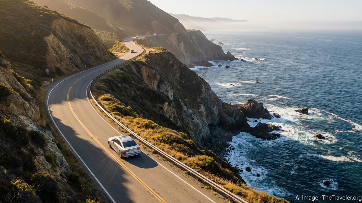
For many visitors, California’s ultimate driving experience is the coast. State Route 1, often referred to as the Pacific Coast Highway in southern sections, hugs the shoreline for long stretches and delivers sweeping views of cliffs, beaches, and ocean. Between Orange County and Los Angeles, it behaves like an urban arterial with frequent lights and local traffic. North of Los Angeles, particularly around Malibu and up toward Ventura, the road begins to feel more open, with beaches on one side and coastal mountains on the other.
The most celebrated portion of the route is between roughly San Simeon and Carmel, where the road threads through Big Sur. Here, steep cliffs, narrow shoulders, and sharp curves demand patient, focused driving. Rockslides and winter storms periodically close sections of the highway, sometimes for extended periods, and repair work can require one way traffic controls. Before committing to this segment, travelers should check current conditions and be prepared for slow speeds, frequent pullouts, and limited services. When the road is open, stopping only in designated turnouts rather than on narrow shoulders is essential for safety.
North of the Bay Area, Route 1 continues as a quieter, more rugged coastal drive through Sonoma and Mendocino counties before eventually rejoining U.S. 101. Here, fog, wind, and sudden curves are all part of the character of the road. Drivers should expect variable weather within a single day, with sunny views suddenly giving way to dense marine layer that dramatically reduces visibility. Using headlights in these conditions, even during daylight, improves both your visibility and your ability to be seen by others.
In Southern California, coastal driving also includes stretches of U.S. 101 and major city boulevards that parallel the shoreline. While these may lack the solitude of Big Sur, they make up for it with easy access to beaches, piers, and waterfront districts. Traffic can be heavy on weekends and during holidays, so leaving early in the morning or traveling on weekdays can help drivers enjoy more relaxed conditions and easier parking near the water.
Mountain Passes, Desert Highways, and National Parks
Beyond the coast and central freeways, California’s interior offers dramatic and sometimes challenging driving environments. The Sierra Nevada range features a series of passes that connect the Central Valley with the eastern side of the state. Some of these routes, such as those leading into Yosemite National Park, are well engineered but still steep and winding, with slow moving vehicles and frequent pullouts. Others are narrow mountain roads that close in winter due to heavy snow and avalanche risks. Summer travelers should anticipate slower travel times, sharp switchbacks, and the potential for overheating on older vehicles during long climbs.
Desert highways, particularly in Southern California, introduce their own considerations. Roads crossing the Mojave or leading toward Death Valley and Joshua Tree can be long and isolated, with significant distances between fuel, food, and water. Daytime temperatures can climb quickly in late spring, summer, and early autumn, which increases the risk of vehicle stress and dehydration for occupants. It is wise to start early, carry extra water, and keep your fuel tank comfortably above empty, especially when venturing off interstates onto quieter state routes or park roads.
National parks and recreation areas often feature lower speed limits, wildlife crossings, and sharp penalties for off road driving or damaging sensitive environments. Within these protected areas, enforcement by rangers can be strict, and drivers should adhere carefully to posted limits and rules. Pullouts and designated viewpoints are common, which allows you to enjoy scenery without blocking traffic. In popular parks such as Yosemite, traffic congestion can be intense during peak season, so leaving your car at a park and ride or using shuttle buses when available can be less stressful than driving into crowded valley floors or viewpoints.
Weather plays an outsized role in mountain and desert driving. Snow, ice, and chain requirements can impact higher elevations from late autumn to early spring, while flash floods and sudden storms can pose risks in arid regions. Checking forecasts, road condition reports, and any seasonal restrictions before departure, then monitoring updates during your journey, helps you avoid unpleasant surprises and last minute detours.
Key California Driving Laws and Rules of the Road
California’s vehicle laws are broadly similar to those in other United States states, but visitors should be aware of several important specifics. Seat belts are mandatory for drivers and all passengers, and child passengers must be secured in appropriate child safety seats or boosters according to their age, height, and weight. Using a handheld mobile phone while driving is prohibited, and drivers are expected to use hands free systems if they must make calls. Texting or other forms of manual phone use while operating a vehicle are illegal and can result in fines.
Speed limits vary by area and road type. On multi lane freeways in ideal conditions, the maximum posted limit is often around 65 miles per hour, with some rural stretches allowing up to about 70 miles per hour. Urban freeways and surface streets can have significantly lower limits, sometimes as low as 25 miles per hour in residential zones or near schools. Enforcement by local police and the California Highway Patrol is common, particularly in areas where speeding has been an ongoing safety issue. It is wise to treat posted limits as true maximums rather than targets, especially in heavy traffic or poor weather.
California has established rules for right of way at intersections, four way stops, and pedestrian crossings. At an all way stop, the first vehicle to arrive has priority, and when vehicles arrive simultaneously, the driver on the right proceeds first. Pedestrians in marked crosswalks, and in many unmarked crosswalks at intersections, have the right of way, and failing to yield can result in citations. Red light cameras and enforcement zones exist in some cities, so rolling through red lights or failing to come to a full stop at right on red turns can carry extra risk.
Driving under the influence of alcohol or drugs is treated seriously, with legal blood alcohol concentration limits in line with national norms and additional penalties for higher readings or repeat offenses. Cannabis use in vehicles is also regulated; open containers are restricted, and impairment from any substance can serve as grounds for arrest. For visitors, a single offense can have long term consequences, affecting driving privileges both in California and potentially in their home jurisdictions.
Local Driving Culture, Carpool Lanes, and Enforcement
Beyond formal statutes, California has a distinct driving culture that varies by region. In dense metropolitan areas, traffic can be fast moving when open and then suddenly congested, requiring constant attention. Lane changes are frequent, and drivers often merge assertively, particularly near on ramps and exits. Using your mirrors, signaling early, and maintaining calm when others drive aggressively is crucial. In more rural or small town areas, the pace generally slows and drivers may be more patient, but slow moving farm equipment or recreational vehicles can create bottlenecks.
High occupancy vehicle lanes, frequently called carpool lanes, are common on major freeways. These lanes are reserved for vehicles carrying at least a specified number of occupants during posted hours, with exceptions for some qualifying clean air vehicles that display special decals. Entry and exit points may be limited to specific sections of the lane marked by broken lines, and crossing solid double lines to enter or leave can result in fines. While carpool lanes can save significant time in heavy traffic, using them properly requires attention to signage and lane markings.
Speed enforcement and traffic monitoring are conducted by a mix of local police departments and the statewide highway patrol. Patrol vehicles may use both marked and unmarked cars, and enforcement zones are clearly posted in some high collision areas. California also has rules about moving over or slowing down when emergency or service vehicles are stopped on the shoulder with flashing lights. Observing these move over requirements protects both first responders and fellow motorists.
Parking rules can be strict, especially in busy city neighborhoods and beach areas. Colored curbs often indicate special restrictions, such as no stopping zones, loading zones, or limited time parking. Street cleaning schedules can result in tickets or towing if you park on the wrong side at the wrong time. Using legal, well marked lots, reading posted signs carefully, and allowing extra time to find parking in popular districts will reduce stress and potential fines.
Planning a Road Trip: Safety, Rentals, and Practical Tips
Successful driving in California starts with realistic planning. The state’s size means that trying to see many distant regions in a short period can lead to long, tiring days behind the wheel. When mapping out your itinerary, consider pairing nearby destinations into clusters and allowing at least several hours of buffer on long drives. Climbing from sea level to mountain passes, or navigating major urban corridors, takes both concentration and time.
If you are renting a car, standard vehicles are adequate for most major attractions, but some remote trailheads or unpaved roads may require higher clearance or four wheel drive. Rental contracts often restrict the use of vehicles on certain unpaved or off road routes, so checking terms before departure is important. Inspect the car for existing damage, test lights and wipers, and confirm how to activate basic features such as cruise control, hazard lights, and, where equipped, lane keeping or adaptive cruise systems.
Basic safety preparation goes a long way in California’s varied environments. Carrying water, snacks, a phone charger, and a simple emergency kit with a flashlight and first aid supplies is prudent. In winter, chains may be required on certain mountain routes, and if you have never used them before, seeking guidance or choosing an alternate route may be wise. During periods of high wildfire risk, smoke or temporary closures can affect roads, so stay informed through local news or official bulletins and be ready to adjust plans.
Fuel availability is generally good along interstates and major state highways, but can become limited in remote areas, coastal stretches, or inside some national parks. Keeping your tank at least half full in rural zones adds a margin of safety. For electric vehicles, public charging networks are expanding, especially in urban areas and along primary corridors, but planning routes around charging stops remains important outside major metropolitan regions.
The Takeaway
Driving in California offers a rare combination of efficiency and adventure, from fast interstates that link major cities to narrow coastal and mountain roads that reveal some of the most striking scenery in the United States. Understanding the structure of the highway system, recognizing how conditions shift between coast, desert, and mountains, and respecting the state’s driving laws will make your experience safer and more enjoyable. While distances can be long and traffic occasionally intense, thoughtful planning and a flexible mindset will help you turn what could be a stressful necessity into one of the great pleasures of your trip.
By balancing iconic drives such as State Route 1 with time on key corridors like I‑5 or U.S. 101, you can craft an itinerary that suits your interests and comfort level. Paying close attention to speed limits, signage, and parking rules, and staying alert to weather and road conditions, ensures that you remain on the right side of both safety and the law. With preparation, patience, and a sense of curiosity, California’s roads become not just a way to get from place to place, but an essential part of the journey itself.
FAQ
Q1. Do I need an international driver’s license to drive in California as a visitor?
Most visitors can drive in California using a valid driver’s license from their home country, as long as it is in English or accompanied by an acceptable translation. An international driving permit can be useful but is typically not required for short stays.
Q2. What is the general speed limit on California freeways?
The maximum posted speed on many California freeways is around 65 miles per hour, with some rural segments allowing up to about 70. Lower limits are common in urban areas, construction zones, and during adverse conditions.
Q3. Are carpool lanes free to use if I meet the occupancy requirements?
In many cases, carpool lanes are free for vehicles that meet the required number of occupants, but some corridors have express lane systems where dynamic tolls may apply. Always read posted signs to understand current rules.
Q4. Is it legal to turn right on a red light in California?
Yes, you may generally turn right on red after coming to a complete stop and ensuring the way is clear, unless signs specifically prohibit it at that intersection.
Q5. What should I know about parking near beaches and tourist areas?
Parking near beaches and popular attractions often has strict time limits, fees, and street cleaning schedules. Always read signs carefully and consider paid lots to avoid tickets or towing.
Q6. How do I handle toll roads and bridges in California?
Some bridges and a few freeway segments use electronic tolling systems, and payment is often collected without cash booths. Rental car companies may offer toll programs, or you can arrange payment using accepted electronic methods in advance.
Q7. Are there specific rules about using a mobile phone while driving?
California prohibits holding a mobile phone while driving. Calls must be hands free, and activities like texting or manually scrolling on devices are illegal and subject to fines.
Q8. When are chains required for driving in the mountains?
During winter storms or icy conditions, authorities may declare chain control on certain mountain roads. Electronic signs and checkpoints will indicate when chains are required or when only four wheel drive vehicles with proper tires may proceed.
Q9. Is it safe to drive through desert areas in summer?
Driving through the desert in summer is possible but requires extra caution. Start early, keep your vehicle well maintained, carry plenty of water, and plan fuel stops carefully to avoid being stranded in extreme heat.
Q10. Can I rely only on my phone’s navigation for a California road trip?
Phone navigation works well in most populated areas, but coverage can be weak in mountains, forests, and remote deserts. Download offline maps in advance or carry a paper map as a backup.