
California is built on movement. The state’s freeways, train lines, local buses and emerging electric vehicle network all promise easy mobility, yet the reality for travelers can be far more complicated. This guide takes a clear-eyed look at what actually works on the ground in 2026, what does not, and how to stitch together the options that make the most sense for your itinerary, budget and tolerance for hassle.
The Big Picture: How Californians Really Get Around
Most visitors arrive in California expecting to drive, and that instinct still reflects how the state is built. Outside a handful of dense urban cores, daily life is organized around freeways, wide arterial roads and large parking lots. Public transit exists in every major metro area, but coverage and frequency vary widely. For many trips, particularly in suburbs and rural regions, a car remains the most reliable way to move on your own schedule.
At the same time, the ground transport landscape is changing. Cities such as San Francisco, Los Angeles and San Diego are gradually improving rail and bus networks, investing in cleaner fleets and faster, more frequent service. Ridership is recovering toward pre‑pandemic levels on several systems, suggesting that when transit is reasonably fast, clean and predictable, travelers will use it. The state government is also pushing longer‑term shifts toward rail and zero‑emission vehicles as part of its climate goals.
For travelers, the result is a patchwork. In some corridors you can move efficiently without a car, linking airports, rail, and local buses or light rail. In others, service gaps, limited late‑night options and infrequent rural routes can turn a simple journey into a multi‑hour puzzle. Understanding where the networks are strong and where they thin out is the key to planning a smooth California trip.
Think of California not as a single unified transport system but as a series of overlapping zones. Major coastal cities are increasingly navigable by transit and rideshare, intercity corridors have reasonably good rail and bus coverage, while much of the interior and far north still requires a private vehicle. The best strategy is often to mix modes rather than rely entirely on one.
Driving and Car Rental: Freedom With Growing Friction
Renting a car continues to be the default choice for many visitors, and for good reason. A car offers unmatched flexibility for exploring coastal highways, wine regions, desert parks and small towns that see limited or no public transit. Road quality on main routes is generally good, signage is clear, and services along major interstates and US highways are frequent. For itineraries that hop between cities and national parks or include remote areas like Big Sur’s backroads or the Eastern Sierra, a rental remains the practical option.
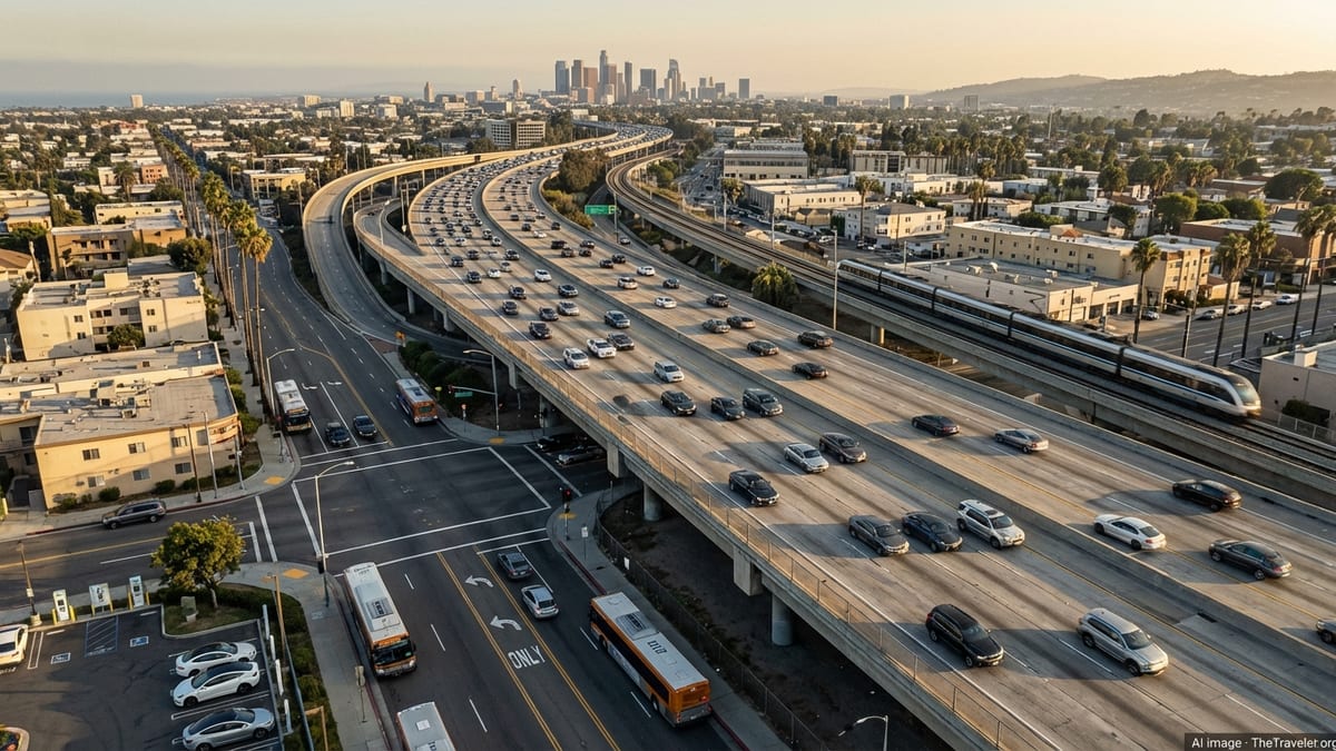
However, driving in California comes with mounting trade‑offs. Traffic congestion in metropolitan areas can be intense, especially on weekday mornings and late afternoons, and around popular beach districts on weekends. Parking has become expensive and sometimes scarce in dense neighborhoods of San Francisco, Los Angeles and San Diego. Travelers who assume they can simply pull up near major attractions and find cheap parking may be forced into costly garages or long walks from distant lots.
Costs are another drawback. Rental car prices have moderated since the worst of the pandemic shortages but can still spike during peak seasons, major conventions and holiday weekends. Fuel is typically more expensive than the national average due to state taxes and environmental regulations. Tolls are far less common than on the East Coast, but some metropolitan express lanes and certain bridges around the Bay Area use electronic tolling that can surprise out‑of‑state drivers if they are not familiar with plate‑based billing or rental company surcharges.
What genuinely works with driving is the ability to design complex, spontaneous trips that link cities with rural and wilderness destinations on your own terms. What increasingly does not work is trying to use a car as your primary way of getting around inside California’s densest urban cores, where traffic, parking costs and local policies often favor transit and walking over private vehicles. For many travelers, a hybrid plan that uses a car for intercity legs and then relies on transit or rideshare while in the city strikes the best balance.
Public Transit in the Cities: Strong Cores, Weak Edges
California’s major metropolitan regions each have their own network of buses, light rail and regional rail, and they differ sharply in how useful they are for visitors. San Francisco and the surrounding Bay Area remain the easiest region to navigate without a car. Within the city, Muni buses and light rail connect most neighborhoods with relatively short waits on core routes, and recent investment in vehicles and transit‑priority lanes has helped restore ridership to a substantial share of pre‑pandemic levels. For trips between San Francisco and nearby cities such as Oakland or Berkeley, regional systems like BART and commuter rail provide faster cross‑bay links than driving during peak traffic.
Los Angeles has expanded its rail network over the last decade and now offers light rail and subway lines that reach from downtown to Santa Monica, North Hollywood, Long Beach and parts of the San Gabriel Valley. These lines can be very effective for specific point‑to‑point journeys, such as connecting downtown to the beaches or transferring between rail and airport shuttles. The challenge is that much of the region’s built environment still favors driving, and transit may require one or two transfers plus walking along wide boulevards. Service is improving on key bus corridors, especially those with bus‑only lanes, but travelers should still expect longer door‑to‑door times than in older transit cities like New York or Chicago.
San Diego and Sacramento offer city transit systems that are useful along certain spines but thin out quickly. San Diego’s trolley lines cover downtown and several suburban corridors, and buses serve popular attractions such as Balboa Park and some beaches. Yet service frequencies can drop in the evening, and routes do not reach every coastal community or inland suburb in a convenient way. Sacramento’s light rail connects downtown to some neighborhoods and suburbs, but service is less dense than in larger metros. In both cities, transit can work well for straightforward trips to central districts but will not fully substitute for a car if you want to explore widely.
Where urban transit works for travelers is in dense, tourist‑heavy corridors: downtown San Francisco to Fisherman’s Wharf, downtown Los Angeles to Santa Monica, or San Diego’s waterfront to Old Town. It becomes less effective when you need to chain together multiple errands or visit neighborhoods far from rail lines. Late‑night service remains a weak point across most California systems, so anyone planning dinners, shows or nightlife should confirm last departures rather than assume trains and buses will run deep into the night.
Intercity Trains and Buses: Mixed Reliability Across Long Distances
For moving between cities, California offers more options than many visitors realize. Amtrak’s state‑supported routes, including the Pacific Surfliner along the Southern California coast, the San Joaquins in the Central Valley and the Capitol Corridor between the Bay Area and Sacramento, provide comfortable, scenic travel with spacious seating and the ability to move around on board. Reserved seating and on‑board Wi‑Fi make these trains attractive alternatives to driving, especially along congested highway corridors. In some cases, total travel time is competitive with cars once you factor in traffic and rest stops.
Amtrak Thruway buses supplement rail service, extending the network to cities not directly on the tracks and filling timetable gaps. Several privately operated intercity bus companies also connect major hubs such as Los Angeles, San Francisco, San Diego and Las Vegas. These services can be cost‑effective and reduce the stress of driving, but quality varies by operator and route, and schedules may be limited to a few departures per day. Bus travel is most effective along high‑demand corridors where multiple companies compete and offer modern coaches, and less appealing on lightly used routes where departures are sparse.
California’s long‑promised high‑speed rail remains a work in progress rather than a current travel option. Construction continues on an initial segment in the Central Valley, and state officials view electrified high‑speed trains as the future backbone of the intercity network, but as of early 2026 there is no passenger service in operation. Travelers should treat high‑speed rail as a future development rather than something to rely on for upcoming trips. In the meantime, existing conventional rail and bus services carry the load, with gradual upgrades in track, stations and rolling stock.
What works well with intercity rail and bus travel is the ability to avoid freeway fatigue and urban traffic, enjoy scenic routes and reduce emissions compared with solo driving. The limitations lie in frequency, susceptibility to delays on shared freight tracks, and the need to plan around fixed departure times. Travelers with flexible schedules, single destinations and moderate luggage often thrive on these services. Those with tight connections, bulky gear or multiple remote stops may find a car or short‑haul flights more practical, even with the extra cost and environmental impact.
Rideshares, Taxis and Micro‑Mobility: Filling the Short‑Trip Gaps
Services such as Uber and Lyft are now deeply embedded in California’s transport ecosystem, especially in large cities and tourist destinations. For many travelers, rideshares excel at bridging the “last mile” between train stations, hotels, restaurants and attractions, or handling trips where parking a rental car would be costly and stressful. They are widely available in metropolitan areas during the day and evening, and pick‑up zones at major airports are clearly signed, if not always conveniently close to the terminal.
The drawbacks largely relate to cost and variability. Surge pricing can make rides expensive during major events, rush hours and weekend nights in entertainment districts. Wait times can spike in outlying suburbs, late at night or in smaller towns, and service quality depends heavily on the individual driver and vehicle. Traditional taxis remain available at airports and in some downtowns, often with regulated fares, but they do not have the same coverage as rideshares away from major hubs.
Shared scooters and dockless or station‑based bikes have become a fixture in several California cities, especially San Francisco, Los Angeles and some college towns. These can be a fast and fun way to cover short distances on dedicated bike lanes, waterfront paths and traffic‑calmed streets. They are less practical on steep hills, in heavy traffic or when carrying luggage. Availability can be inconsistent between neighborhoods, and local rules about where you may ride and park are actively enforced in some areas.
Where these micro‑mobility options shine is in compact, relatively flat districts with visible bike infrastructure, such as parts of Santa Monica, downtown San Diego’s waterfront or central San Francisco. They work poorly on high‑speed arterials, in areas without bike lanes, or for travelers unfamiliar with riding in urban traffic. Helmets are strongly recommended, and some jurisdictions require them for riders below certain ages. Travelers should also factor in that app access and payment usually require a data connection and a compatible smartphone.
Electric Vehicles and Charging: Better, But Not Effortless
California is one of the easiest places in the United States to rent and drive an electric vehicle, thanks to widespread adoption and a rapidly growing public charging network. The state has surpassed two hundred thousand public and shared charging ports, far more than in most regions of the country. Many hotels, shopping centers and visitor attractions offer Level 2 chargers in their parking facilities, and fast‑charging stations now line the main interstates used for coastal and cross‑state road trips.
For travelers comfortable with basic route planning, an EV can work very well on popular corridors such as Los Angeles to San Diego, Los Angeles to Palm Springs, or up and down the spine of the Central Valley. Modern models typically offer enough range to cover several hours of freeway driving between charges, and apps from both vehicle manufacturers and independent networks make it easier to locate available chargers and monitor charging status. The driving experience itself is quiet and responsive, often making long drives less tiring than in traditional gasoline cars.
The weak spots appear when you move off the main arteries or travel in peak holiday periods. Fast‑charging coverage in rural mountain regions, remote desert areas and some coastal stretches remains patchy. Chargers can occasionally be out of service or congested, creating delays for drivers who arrive with a low battery and limited alternatives nearby. Level 2 chargers at hotels are convenient overnight but may be shared among many vehicles, so you cannot assume a dedicated spot will be available upon arrival unless specifically reserved or confirmed with the property.
In practical terms, EVs work best for travelers who are willing to build charging stops into their itinerary, choose routes that track major highways and stay at accommodations that explicitly offer charging on site. They are less suitable for spontaneous detours far from the network, or for tightly timed itineraries where an unexpected wait at a busy charger would cause missed tours or check‑ins. For many visitors, a plug‑in hybrid can be a safer compromise, offering some electric driving in cities with the backup of a gasoline engine for remote stretches.
Airports, Shuttles and Station Transfers: The First and Last Miles
California’s major airports vary significantly in how easy they are to enter and exit without a private car. San Francisco International and Los Angeles International both connect to regional rail systems through people movers and dedicated transit lines, allowing travelers to reach downtowns without renting a car or taking a taxi. Oakland and San Diego airports also provide bus or rail links to nearby transit hubs. When these systems are running frequently, they offer a predictable, often faster path into the city than battling highway congestion in a car.
Airport shuttles and shared ride vans once common at terminals have become less universal, replaced in many locations by a mix of rideshares and hotel‑operated minibuses. Some regions still maintain regional bus links from airports to outlying cities, particularly in the Central Coast and Central Valley. These can be very useful for budget‑conscious travelers or those planning to rely on transit once they reach their base city. However, they often run on limited schedules, sometimes only a few times a day, and may require prebooking.
Railway and intercity bus stations within cities are generally centrally located, but station‑area environments differ. Some, like the main stations in downtown Sacramento or San Diego, sit within walking distance of hotels and restaurants. Others are in industrial districts that feel less comfortable late at night. In most cases, a short rideshare or local bus ride completes the journey from station to lodging. Planning this last leg in advance helps avoid confusion upon arrival, especially after long journeys or in unfamiliar neighborhoods.
What works well in the airport and station context is using rail links and clearly marked shuttle services for the main trunk into the city, then switching to rideshare or transit for the final approach. What fails travelers most often is assuming that every airport or station will have frequent, simple public transport at all hours. In reality, late‑night arrivals and early‑morning departures can intersect with thinner service, so checking timetables and arranging backup options is essential.
The Takeaway
Navigating California efficiently in 2026 means embracing a layered approach rather than relying on a single mode of transport. Driving still unlocks vast portions of the state, particularly national parks, wine regions and rural coastlines, but it is no longer the only viable option in and between major cities. Public transit in urban cores, when used along its stronger corridors, can be both practical and economical. Intercity trains and buses offer a comfortable alternative to freeways on many routes, especially for travelers without tight schedules.
Electric vehicles, rideshares and micro‑mobility add further nuance. EVs are increasingly realistic for road trips that stick to well‑served corridors and plan for charging, while scooters and bikes can be ideal for short hops in dense, bike‑friendly districts. Rideshares and taxis seal the gaps when luggage, late‑night arrivals or awkward station locations make other choices impractical. No single mode is perfect, but each has contexts where it clearly works and others where it falls short.
For travelers, the most successful California itineraries tend to share a few traits. They leverage rail or bus where it is strong, reserve cars for genuinely car‑dependent regions, and avoid driving in the densest urban cores when better alternatives exist. They account for late‑night and early‑morning service limitations, especially around airports, and treat new technologies like EVs and shared scooters as useful tools rather than magic solutions. With this mindset, California’s evolving transport network becomes not a barrier but an integral, even enjoyable, part of the journey.
In short, what works in California ground transport is informed choice and flexibility. What does not work is assuming that one mode will carry you seamlessly from beach town to mountain trail to downtown high‑rise. Take the time to understand the strengths and weaknesses of each option, plan around them, and you will discover that the state’s vast distances and tangled freeways conceal a surprisingly rich set of ways to move.
FAQ
Q1. Can I visit California without renting a car?
Yes, if you focus on well‑served urban areas and intercity corridors. Cities like San Francisco and parts of Los Angeles, plus rail routes such as the Pacific Surfliner, can support a car‑free itinerary, but rural areas and many national parks still require a vehicle or organized tours.
Q2. Is public transit in California safe for visitors?
Generally yes, especially during the day and on busy routes. As in any large city, it is wise to stay aware of your surroundings, keep valuables out of sight and sit near other riders or the operator at night.
Q3. How reliable are California trains for long‑distance travel?
Intercity trains are comfortable and often scenic, but they can be affected by delays, particularly on tracks shared with freight. They work best if you can allow some schedule flexibility and avoid tight same‑day connections.
Q4. Should I consider an electric vehicle for a California road trip?
Yes, for trips along major corridors with good fast‑charging coverage, especially if your accommodations offer charging. For remote regions or complex itineraries, a gasoline car or plug‑in hybrid may be less stressful.
Q5. Are rideshares easy to find outside major cities?
Rideshares are widely available in large metros and many mid‑sized cities, but service can thin out in smaller towns and rural areas, particularly late at night. In those regions, do not rely on rideshares as your only option.
Q6. What is the best way to get from the airport to downtown?
Where available, airport rail links or dedicated buses are usually the quickest and most predictable options. Otherwise, rideshares and taxis provide straightforward door‑to‑door service, though often at a higher cost.
Q7. Can I use bikes and scooters safely in California cities?
Yes, in many areas with visible bike lanes and calmer streets, bikes and scooters can be convenient. Riders should follow traffic laws, wear helmets where required and avoid high‑speed arterials without dedicated infrastructure.
Q8. How far in advance should I book intercity buses or trains?
For busy weekends, holidays and popular routes, booking several days or more in advance is sensible. On many routes you can buy tickets closer to departure, but planning ahead improves seat choice and sometimes price.
Q9. Is late‑night public transit widely available?
Late‑night service exists in some core corridors but is limited overall, especially in smaller cities and suburbs. If you plan to be out late, confirm last train or bus times and consider rideshares as a backup.
Q10. How do California’s traffic conditions affect travel plans?
Traffic can be heavy around major metros, particularly at commute times and on weekend afternoons near beaches and popular destinations. Building extra time into your schedule, traveling outside peak hours when possible and using real‑time navigation can reduce stress and delays.