
Cape Point, with its saw-toothed cliffs and restless seas, is one of South Africa’s most dramatic coastal landscapes. Set near the southern tip of the Cape Peninsula, it is part of Table Mountain National Park and lies within the broader Cape Floral Region, a UNESCO World Heritage Site.
Travelers are drawn here not only by the romance of “the end of Africa,” but also by the remarkable combination of rugged geography, rich wildlife, and some of the most scenic coastal drives in the world.
Where Exactly Is Cape Point?
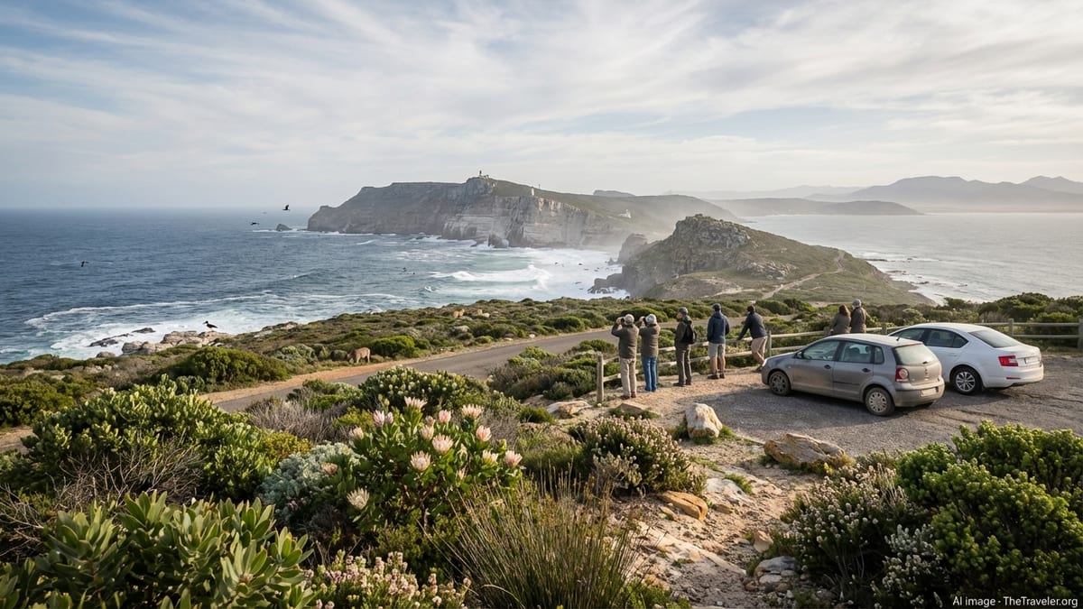
Cape Point occupies the southern end of the Cape Peninsula, a mountainous finger of land that stretches south from central Cape Town into the Atlantic Ocean and False Bay. The point falls within the Cape of Good Hope section of Table Mountain National Park, a protected area that preserves indigenous fynbos vegetation and a long sweep of unspoiled coastline. Although many visitors assume that Cape Point is the southernmost tip of Africa, that title belongs to Cape Agulhas further east. Cape Point and the nearby Cape of Good Hope instead mark the southwestern extremity of the continent and the meeting place of powerful oceanic influences.
Geologically, the peninsula is dominated by hard Table Mountain sandstone, a resistant rock that weathers slowly and forms sheer cliffs, broken ridges, and isolated peaks. Over millions of years, waves and wind have carved the coast into bays, headlands, and towering sea cliffs. At Cape Point these processes are on full display, with the narrow promontory plunging into deep water and smaller coves tucked into its flanks. The result is a landscape that feels simultaneously remote and accessible, within a couple of hours’ drive of central Cape Town yet seemingly far removed from city life.
From an orientation point of view, the reserve is bounded by the Atlantic Ocean on the west and False Bay on the east. Roads loop through the interior of the park, connecting viewpoints, picnic areas, and beaches such as Buffels Bay and Bordjiesrif. The Cape of Good Hope, a lower, rockier headland famous in maritime history, lies a short distance west of Cape Point itself and is reachable by road and walking paths. Together, these two landmarks create the iconic image of the Cape Peninsula’s wild southern terminus.
The Dramatic Geography of the Cape Peninsula
The experience of Cape Point only makes full sense in the wider context of the Cape Peninsula’s geography. North of the point, a spine of mountains runs toward Cape Town, punctuated by peaks such as Constantiaberg and the more northerly Table Mountain. These peaks are part of the same sandstone formation that forms the cliffs at Cape Point. The range separates the cool Atlantic coast from the more sheltered False Bay side, influencing local weather patterns and creating a mosaic of microclimates.
Cliffs of up to 200 meters drop almost vertically into the sea around Cape Point, giving visitors sweeping views that can extend, on a clear day, across False Bay to the distant Hottentots Holland Mountains. The narrowness of the peninsula at its southern end heightens the sense of being on a sliver of land embedded in the ocean. The sea here is anything but placid. Swells driven by the Southern Ocean meet local currents, and winds funnel around the headlands, creating notoriously changeable conditions. For centuries, sailors regarded these waters with a mixture of awe and dread, a reputation reflected in the many shipwrecks that lie along the nearby coasts.
Inland from the cliffs, low ridges and shallow valleys host pockets of sandy soils and rocky outcrops. While the relief is less spectacular than at the immediate coastline, it is critical for the region’s biodiversity. Seasonal wetlands form in depressions, and coastal plains offer grazing for large antelope. The geography creates a sequence of vistas as you drive or walk through the reserve: one moment you are surrounded by shoulder-high fynbos, the next you emerge onto a lookout where the sea seems to stretch endlessly in three directions.
The Cape Floral Kingdom and Fynbos Ecosystems
Beyond the cliffs and ocean views, Cape Point is part of one of the world’s great botanical treasures. The Cape Floral Kingdom, the smallest of the planet’s six floral kingdoms, is also one of the richest in terms of plant diversity and endemism. Fynbos, the signature vegetation type, dominates the landscape. This shrubland, adapted to nutrient-poor soils and periodic fires, is characterized by tough-leaved proteas, heaths, and restios, along with a variety of bulbs and flowering shrubs that create splashes of color at different times of year.
Visitors driving to Cape Point in late winter and spring may notice hillsides dusted with blooms, from bright yellow leucadendrons to delicate ericas. Many of these plants occur nowhere else on Earth. The harsh conditions of wind, salt spray, and lean soils have selected for species that conserve water, tolerate fire, and anchor themselves in shifting sands or shallow rocky crevices. Conservation agencies prioritize the control of invasive alien plants in the reserve because even small disturbances can displace specialized fynbos communities.
Fynbos also supports a complex web of ecological relationships. Certain proteas are pollinated by sugarbirds and sunbirds, which in turn depend on the nectar-rich flowers for food. Small mammals such as native mice and shrews forage among the shrubs, while reptiles bask on rocks during sunny spells. Fire, often sparked by lightning or human activity, plays a central role in renewing fynbos. Many plants are adapted to germinate after burns, and management plans aim to allow natural fire cycles while reducing the risk to infrastructure and visitors.
Wildlife: From Antelope to Coastal Birds
Although Cape Point is not a “big five” safari destination, it hosts a surprisingly diverse range of wildlife. Eland, the world’s largest antelope, graze on open slopes and in coastal grasslands within the reserve, sometimes appearing close to picnic sites or along access roads. Smaller antelope such as bontebok and grey rhebok also occur, taking advantage of grassy patches among the fynbos. The reserve is one of the few places on the peninsula where such species roam relatively freely in a near-natural setting.
Cape mountain zebra, a stocky, sure-footed subspecies adapted to rugged terrain, may be seen in quieter areas of the park. Ostriches patrol the coastal flats and are often spotted near beaches like Buffels Bay, where their silhouettes against the ocean make for memorable photographs. Visitors should keep a respectful distance, especially during breeding season, as even seemingly placid animals can become defensive.
Marine and coastal wildlife are another highlight. Southern right whales visit False Bay seasonally, typically from the Southern Hemisphere winter into spring, when they come close to shore to calve and rest. From elevated viewpoints above the bay, patient observers can sometimes spot blows, tail flukes, or even breaching whales. Dolphins occasionally move through the surrounding waters, and offshore islands along the broader peninsula host Cape fur seals. Rocky shores near the reserve support intertidal life, from anemones to limpets, revealed at low tide on accessible stretches of coast outside the most exposed headlands.
Birdlife is particularly varied. In addition to nectar-feeding species associated with fynbos, coastal birds such as cormorants, gulls, and oystercatchers work the wave-washed rocks. Raptors patrol the cliffs, riding updrafts created by onshore winds. For casual visitors, the combination of large, easily visible species like ostrich with a background chorus of smaller birds creates a sense of a living, dynamic landscape rather than a static scenic backdrop.
Managing Human–Wildlife Encounters
With high visitor numbers and a semi-wild setting, managers at Cape Point devote substantial effort to handling interactions between people and wildlife. The most visible challenge involves chacma baboons, intelligent primates that have learned to associate humans and vehicles with food. In the past, unsecured picnics and open car windows led to frequent raids, resulting in injuries, property damage, and habituated animals that were difficult to manage.
Current policies emphasize minimizing food access and discouraging feeding of any kind. Park authorities deploy monitors to move baboon troops away from busy areas and educate visitors about keeping distance, securing food in closed containers, and never confronting animals. Signage throughout the reserve reinforces these messages. Travelers who understand and respect these guidelines help reduce conflict and support the long-term survival of the baboon population in the area.
Similar principles apply to other species. Feeding ostriches or antelope is prohibited, as it can alter natural behavior and create dependency. Speed limits on internal roads are set to reduce the risk of collisions with wildlife, especially at dawn and dusk when animals are more active. For predators such as smaller carnivores or raptors, minimal disturbance is the goal: staying on designated paths and refraining from approaching nests or dens protects both animals and people.
Reaching Cape Point: Scenic Routes and Classic Drives
Getting to Cape Point is part of the appeal, with the Cape Peninsula offering some of South Africa’s most photogenic roads. Many visitors choose to approach along Chapman’s Peak Drive, a renowned coastal route that runs between Hout Bay and Noordhoek on the Atlantic side of the peninsula. This approximately nine-kilometer road hugs steep mountainsides, with more than a hundred bends opening onto views of cliffs, ocean, and wide sandy bays. It operates as a toll road, with fees contributing to ongoing rockfall protection and maintenance, and may close temporarily in severe weather or when safety work is underway.
Chapman’s Peak Drive is widely described by travel writers as one of the world’s great marine drives, not only for its scenery but also for its engineering. Sections of the road were cut into sheer rock faces, and protective tunnels and nets now shield vehicles from rockfalls. There are several designated viewpoints where drivers can pull over, stretch their legs, and photograph the coastline. When combined with a visit to Cape Point, the route creates a loop that showcases both the Atlantic and False Bay sides of the peninsula.
On the eastern flank, roads through coastal communities such as Muizenberg, St James, Kalk Bay, Fish Hoek, and Simon’s Town trace the shore of False Bay. This route offers a more urban flavor, with Victorian-era buildings, working harbors, and beaches popular with swimmers and surfers. Just outside Simon’s Town, the Boulders Beach area is famous for its colony of African penguins, making it a natural stop on the way to the reserve. Continuing south, the main road passes through smaller settlements before entering the Cape of Good Hope section of Table Mountain National Park.
Travelers often design a full-day circuit that starts in central Cape Town, follows Chapman’s Peak Drive to Noordhoek, crosses to the peninsula’s eastern side, visits the penguins at Boulders, and then continues to Cape Point and the Cape of Good Hope. Returning to the city can be done along the False Bay route or via inland roads through the southern suburbs. Road conditions on the main routes are generally good, but tight curves, narrow shoulders, and strong winds mean drivers should allow extra time and avoid rushing, especially if stopping frequently for photographs.
Exploring Cape Point: Viewpoints, Trails, and the Funicular
Once inside the reserve, a network of roads and paths makes it easy to explore key viewpoints and quieter corners. The main parking area near the base of Cape Point gives access to the headland itself. From here, visitors can walk up a steep but well-maintained path to the old lighthouse, a stone structure perched high above the sea. The climb is short but can feel strenuous in hot or windy conditions, with steps and paved sections weaving through fynbos and past lookouts with progressively wider views.
For those who prefer not to walk the entire way, the Flying Dutchman Funicular provides a short rail journey from the lower station near the car park to an upper station closer to the lighthouse level. Operating since the mid-1990s, it was the first commercial funicular of its type in Africa. The ride takes only a few minutes, passing through low vegetation with glimpses of the cliffs and ocean, and is particularly popular with families and travelers with limited mobility.
Beyond the old lighthouse, a path continues toward the new lighthouse, built lower down on a more exposed section of cliff to improve visibility in poor weather. Additional paths lead along the ridge to side viewpoints that look out over the confluence of swells and the jagged coastline on both the Atlantic and False Bay sides. For safety, visitors are advised to stay behind railings and avoid venturing too close to sheer edges. Gusting winds are common, and waves can strike the base of the cliffs with enough force to send spray high into the air.
Elsewhere in the reserve, shorter walks connect beaches, tidal pools, and interior lookouts. Around the Cape of Good Hope, paths climb modest hills that yield sweeping panoramas of the headlands and bays. The relative openness of the landscape, dominated by low vegetation rather than tall trees, ensures that even brief strolls can feel expansive. Signposted trails of varying length allow more experienced hikers to explore less frequented areas, although conditions can change quickly and appropriate clothing, water, and navigation tools are essential.
Weather, Seasons, and Safety Considerations
The weather at Cape Point is famously changeable. Located at the junction of ocean currents and exposed to prevailing winds, the peninsula can experience four seasons in a single day. In summer, typically from December to March, conditions are often warm and dry, but strong southeasterly winds can bring dust, haze, or sudden drops in temperature. In winter, from about June to August, cold fronts sweep in from the Atlantic, bringing rain, low cloud, and occasionally dramatic seas that pound the cliffs.
For travelers, preparation is crucial. Layered clothing, including a windproof outer layer, is advisable even on seemingly clear days. Sun protection is important in all seasons, as ultraviolet levels are high and the combination of cool breezes and reflective ocean surfaces can make sunburn more likely. Footwear with good grip is recommended, especially on paths that can become slippery when wet. Fog and low cloud can reduce visibility near the headlands, obscuring views and making it harder to judge distances at cliff edges.
Park authorities monitor conditions and may temporarily restrict access to specific areas if safety is compromised. On the approach routes, Chapman’s Peak Drive in particular can close due to heavy rain or high winds because of rockfall risk. Within the reserve, walking off marked paths is discouraged. Mobile phone reception is generally good on higher ground but may be patchy in some low-lying or remote areas. Carrying water is essential, as services within the park are limited to designated visitor nodes and there are long stretches without shade.
The Takeaway
Cape Point distills the essence of the Cape Peninsula into a single, powerful setting. Cliffs of pale sandstone plunge into restless seas, while tough fynbos plants cling to slopes shaped by wind and fire. Wildlife, from heavy-footed eland to quick, darting birds, moves through a landscape that has challenged sailors, inspired explorers, and now captivates travelers from around the world.
The journey to the point, whether along the switchbacks of Chapman’s Peak Drive or the gentler curve of the False Bay coast, is as memorable as the destination itself. Once there, the interplay of geography, weather, and wildlife offers constantly shifting scenes: clouds rolling over ridges, shafts of light striking distant peaks, or whales surfacing in the bay below. It is a place where the boundaries between land and sea, urban and wild, feel porous and dynamic.
For visitors who approach with curiosity and respect, Cape Point is more than a viewpoint at the end of the road. It is an introduction to the broader story of the Cape’s unique ecosystems, its maritime heritage, and the delicate balance required to protect such a distinctive landscape in a modern, busy world.
FAQ
Q1: Is Cape Point the southernmost tip of Africa?
Cape Point is the southwestern tip of the Cape Peninsula but not the southernmost point of Africa. That distinction belongs to Cape Agulhas, located further east along the coast. Many travelers visit both sites, but Cape Point is closer to Cape Town and more dramatic in terms of cliffs and coastal scenery.
Q2: What is the difference between Cape Point and the Cape of Good Hope?
Cape Point is the high, narrow headland topped by lighthouses and lookouts, while the Cape of Good Hope is a lower, rocky promontory a short distance to the west within the same reserve. Both lie inside the Cape of Good Hope section of Table Mountain National Park and are connected by roads and walking paths.
Q3: How long does it take to visit Cape Point from Cape Town?
Most visitors allow a full day for a round trip from central Cape Town. Driving time each way can be around 60 to 90 minutes depending on the route and traffic, but stops along Chapman’s Peak Drive, Boulders Beach, and viewpoints inside the reserve easily turn the excursion into a leisurely, full-day outing.
Q4: Do I need a car to reach Cape Point?
A private car offers the most flexibility, especially for stopping at scenic viewpoints, but it is not essential. Guided tours operate from Cape Town and typically include transport, commentary, and visits to other attractions along the peninsula. Some visitors combine public transport and ride-hailing services for part of the journey, but this requires more planning.
Q5: What kind of wildlife can I expect to see?
Common sightings include eland, bontebok, ostriches, and various smaller antelope, as well as baboons and a wide array of birdlife. In season, you may spot southern right whales in False Bay from elevated viewpoints. While large predators are not a feature of the area, the combination of land and coastal species makes wildlife viewing rewarding.
Q6: Is it safe to walk around Cape Point?
Designated paths and lookouts are generally safe for visitors who respect signage and stay behind barriers. The main risks are strong winds, steep cliffs, uneven surfaces, and sudden weather changes. Good footwear, appropriate clothing, and sensible behavior near edges are essential. Solo hiking on longer, remote trails should be approached with caution and proper preparation.
Q7: When is the best time of year to visit?
Each season offers something different. Summer brings longer days and warmer temperatures, but also stronger winds and more visitors. Winter can deliver dramatic seas and clearer air between cold fronts, though rain and low cloud are more common. Spring and early summer often feature fynbos blooms and comparatively mild conditions. Checking a short-term forecast before visiting is advisable at any time of year.
Q8: What should I wear and bring for a day at Cape Point?
Layered clothing, including a windproof jacket, sturdy walking shoes, a hat, and sunscreen are recommended. Carry sufficient drinking water and snacks, as facilities are concentrated at a few nodes rather than spread throughout the park. A camera or binoculars enhance the experience, especially for observing wildlife and distant views.
Q9: Is the Flying Dutchman Funicular worth using?
The Flying Dutchman Funicular is convenient for those who prefer to avoid the steepest part of the walk to the old lighthouse or who have limited mobility. It offers a short, scenic ride and reduces climbing time, allowing more visitors to enjoy the upper viewpoints. Fit travelers may choose to walk both ways but often combine one direction on foot with a ride.
Q10: Can I swim at beaches within the Cape Point reserve?
Several beaches inside the wider reserve, such as Buffels Bay and Bordjiesrif, have calmer areas suitable for paddling or swimming in good conditions, sometimes with tidal pools. However, water temperatures can be cold, currents strong, and weather changeable. Lifeguard presence is limited, so caution is essential and entering the water at exposed or unsupervised spots near the headlands is not recommended.