
More news on this day
From the arches of Clifton to the rail bottlenecks of Oxford and the leafy paths near Plym Bridge, a trio of high-profile schemes scheduled around 2026 is reshaping how Britain thinks about getting from A to B. Together they signal a decisive push to prioritise rail capacity, safer roads and active travel routes, as ministers promise that better connectivity and greener journeys will underpin the country’s economic recovery.
Clifton and the New Era of River Crossings
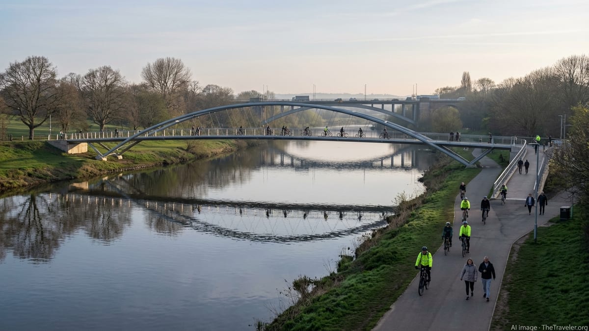
In the Midlands, the area long associated with Clifton Bridge over the River Trent is becoming a symbol of how the UK is reworking its river crossings for a different kind of mobility. While Clifton’s 1960s-era road bridge remains a vital artery for traffic skirting Nottingham, the focus in 2026 is shifting a short distance along the river to a new generation of crossings designed primarily for people on foot and on bikes. At the heart of this shift is a new pedestrian and cycle bridge over the Trent, conceived to complement the existing highway structures and ease pressure on some of the region’s most heavily used roads.
The new crossing, carrying only walkers and cyclists, is due to open in spring 2026 and will be the first bridge to span the river in Nottingham since Clifton Bridge was completed some six decades ago. Engineers lifted the main span into place in late 2025, in a delicate operation that underlined how much more complex it now is to build new infrastructure within densely populated urban corridors. The structure’s network-arch design reflects a wider move in bridge engineering towards lighter, more efficient forms that can integrate with riverside parkland rather than dominate it.
For transport planners, the bridge is a response to two overlapping pressures: mounting congestion on urban approaches to Clifton Bridge, and a growing appetite for active commutes along the Trent. The aim is to pull local trips off the main road network and onto a continuous traffic-free route linking riverside neighbourhoods to business districts and tram stops. City officials argue that offering a realistic alternative to short car journeys is a more sustainable way of protecting the strategic function of existing bridges than simply adding more road capacity.
The project has also become a test case for how quickly the UK can deliver medium-scale schemes when there is political momentum and relatively modest engineering risk. Unlike some large highway projects that have struggled with costs and planning objections, the Nottingham crossing has advanced steadily from concept to construction, providing a model for other cities that are exploring similar people-first bridges near older road crossings such as Clifton.
Oxford’s Botley Road Works and a Rail Hub Under Pressure
Nowhere are the tensions between local disruption and long-term benefit more visible than in Oxford, where a multi-year overhaul of the city’s western rail approaches has turned Botley Road into a byword for congestion and frustration. The closure of the key radial route under the railway in 2023 for bridge replacement, flood defences and utility diversions was originally expected to last around 18 months. Instead, a series of complications beneath the road surface, including complex buried utilities and drainage structures, has pushed the full reopening date back to August 2026.
Network Rail and Oxfordshire County Council insist that the reprogrammed works will finally unlock a step-change in capacity at Oxford station. The project includes a wider road bridge, improved flood protection, upgraded sewers and new box structures to support additional tracks and platforms. Officials say that the station throat is currently close to its operational limits, constraining both intercity services and the launch of new regional routes. By rebuilding the bridge and realigning track, engineers aim to create space for an extra platform on the western side and more flexible signalling, paving the way for more frequent services across the Thames Valley and beyond.
The price has been years of disruption for residents, businesses and bus users who rely on Botley Road as a main route into the city centre. Local politicians have repeatedly pressed Network Rail for firmer timetables and clearer communication, while small firms along the corridor report reduced footfall and higher delivery costs. In response, project managers have introduced measures such as enhanced information sessions, targeted local bus services and revised phasing, including an emphasis on opening new pedestrian and cycling routes ahead of the final road works to restore some connectivity.
Rail engineers face a critical possession window between 1 and 8 February 2026, when the railway over Botley Road will be closed so the old bridge can be demolished and its replacement installed. During that period, buses will substitute for trains between Oxford and Didcot Parkway, and the existing walkway beneath the bridge will be diverted through the station using temporary step-free structures. That intensive week of work is expected to mark the turning point towards completion, allowing road reconstruction, utilities reinstatement and surface works to continue through the summer ahead of the planned August reopening.
Transforming Oxford Station for East West Rail and Beyond
Botley Road’s upheaval is only one element of a broader, nearly £200 million investment in Oxford’s rail hub that is scheduled to shape services well into the 2030s. The city sits at a strategic crossroads between north-south intercity routes, freight movements and the emerging East West Rail corridor linking Oxford to Milton Keynes and Cambridge. For years, constrained platforms, flat junctions and a narrow bridge over Botley Road have throttled the number of trains that can pass through each hour.
The current programme, centred on an expanded western side of the station, is designed to unlock that constraint. Plans include a new through platform, additional track, a second station entrance and a wider highway bridge, along with redesigned approaches for buses, bikes and taxis. Once complete, Network Rail says the station will be able to handle at least three more passenger trains per hour and a significant uplift in freight paths. That extra capacity is vital for the staged rollout of East West Rail services and proposals to open the Cowley branch line to passenger trains, which would connect new housing and employment sites to the national network.
Alongside the heavy rail works, Oxford is reshaping how people move through the station precinct on foot and by bike. A new four metre wide pedestrian and cycle route on the north side of Botley Road is due to be followed by an equally wide route on the south side when the road reopens, replacing the cramped tunnel that long served as an uncomfortable pinch point. Elevated from the carriageway and segregated between walkers and cyclists, the twin underpasses are intended to accommodate a rapid growth in active travel and support the city’s low-traffic neighbourhoods and bus-priority measures.
Local officials argue that integrating these improvements with the station upgrade is essential if Oxford is to absorb rising passenger numbers without overwhelming its medieval streetscape. They see the project as an example of how rail investment, bus planning and cycling infrastructure can be designed together, rather than in isolation. The test in 2026 and beyond will be whether residents feel that the years of disruption and detours have been justified by more reliable trains, safer crossings and smoother journeys between west Oxford, the city centre and the wider region.
Plym Bridge Corridor: From Disused Railway to Strategic Green Route
Further south-west, the area around Plym Bridge and the eastern approaches to Plymouth is showing how former railway alignments are being repurposed to support modern travel habits. Over the past decade, the city has gradually converted stretches of disused trackbed near the River Plym into a continuous, largely off-road walking and cycling route. That work has already included reopening the Laira Rail Bridge to non-motorised users and creating several phases of shared path linking new housing to the city centre.
The next stage of this programme, taking shape in the mid-2020s and feeding into the 2026 network, focuses on extending the route through Plymstock by unblocking an old rail bridge under Colesdown Hill and pushing the path onto Elburton Road. The aim is to create a direct, accessible corridor for people walking, cycling or using mobility aids, connecting residential districts to schools, employment zones and bus interchanges without forcing users onto busy arterial roads. Council documents describe the long-term goal as a continuous strategic cycle spine running along the old railway towards Plym Bridge and beyond.
Transport planners in Plymouth argue that such green corridors serve multiple roles at once. They provide safe, family-friendly routes for everyday trips, support tourism by linking into riverside trails and country parks near Plym Bridge, and offer an alternative to car-based commuting on constrained suburban roads. In policy terms, they also contribute to carbon and air-quality targets by making it easier to choose active modes for journeys of a few kilometres, which make up a significant share of urban travel.
Delivering each segment has required patching together funding from local budgets, developer contributions and national active travel grants. Progress has therefore been incremental, but by the time the Colesdown Hill link is open and tied in with other works around 2026, much of the original railway alignment will have been transformed into an accessible, surfaced route. The city hopes that this will in turn strengthen the case for further investment towards Tavistock and the wider hinterland, knitting the Plym Bridge corridor more closely into the region’s transport map.
National Strategy: Linking Local Schemes to a Bigger Transport Vision
The upgrades at Clifton, Oxford and along the Plym Bridge corridor are part of a wider recalibration of how the UK funds and delivers its transport infrastructure. Ministers have repeatedly stressed that improving existing road and rail assets, and adding selective new capacity, is central to unlocking growth and supporting the delivery of new homes. Recent funding announcements have bundled major strategic highways with smaller but locally transformative rail and active travel projects, arguing that all contribute to productivity and access to jobs.
In practice, this has led to a patchwork of schemes moving forward on different timescales, from large multibillion-pound tunnels and bypasses to comparatively modest bridge widenings and path extensions. Clifton’s new pedestrian and cycle bridge over the Trent, for example, sits alongside much larger investments in motorway junctions and trans-Pennine upgrades on national priority lists. Oxford’s station expansion is closely tied to the East West Rail programme, a flagship rail corridor intended to knit together regional economies without routing every journey through London.
Officials at the Department for Transport describe the 2026 period as a turning point, with multiple projects finally reaching delivery after years of planning. They argue that while individual closures and diversions can be deeply unpopular in the short term, the cumulative effect of these investments should be more reliable rail services, safer and less congested roads, and a dense network of active travel routes in and around urban centres. That in turn, they say, will support labour mobility and make regional cities such as Nottingham, Oxford and Plymouth more attractive to both residents and employers.
Critics, however, point to the pattern of delays and cost increases on several schemes, using the Botley Road experience in Oxford as a cautionary tale. They warn that unless lessons are learned about early ground investigations, utility coordination and community engagement, the risk of disruption and budget overruns will remain high. With public finances under pressure, the performance of the 2026 wave of projects will be closely watched as a test of whether the UK can deliver complex infrastructure on time and within revised budgets.
Economic, Environmental and Social Payoffs
Behind the engineering details lies a broader question: what kind of transport system do these upgrades signal for the next generation of travellers? At Clifton and along the Trent, the answer leans towards a more balanced mix of road capacity and dedicated space for people walking and cycling. In Oxford, the emphasis is on squeezing more out of an intensively used rail corridor while reshaping local road layouts to favour buses and active modes. Around Plym Bridge, the shift is more radical, taking corridors once reserved for freight trains and handing them over almost entirely to non-motorised users.
Economists argue that these changes, while disruptive during construction, are likely to yield long-term dividends. Extra rail paths at Oxford should make it easier to run frequent commuter and regional services, cutting journey times and improving reliability for thousands of passengers each day. Enhanced river crossings near Clifton promise to reduce delays for drivers by moving local trips onto parallel active routes, while also boosting footfall along regenerated waterfronts. In Plymouth, a fully formed Plym Bridge greenway could support local businesses that depend on tourism and outdoor recreation, while giving residents more choice in how they travel to work or school.
The environmental benefits are also central to the case for these schemes. More people walking, wheeling or cycling in Nottingham and Plymouth, combined with mode shift from road to rail in and out of Oxford, should help cut tailpipe emissions and improve local air quality. In Oxford’s case, new flood defences and upgraded drainage around Botley Road are designed to make critical infrastructure more resilient to extreme weather, reducing the risk of future closures that would force traffic onto diversion routes. At a national level, these incremental gains form part of a wider push to align transport policy with net-zero commitments.
Socially, better designed bridges and paths can open up travel options for people who do not drive or own a car. Step-free walking routes under Botley Road, accessible gradients on the Plymstock paths and traffic-free crossings at the Trent bridge are all being promoted as examples of inclusive design. Advocacy groups emphasise that if the UK is serious about levelling up access to jobs, education and healthcare, investments cannot be limited to headline-grabbing megaprojects but must also focus on the everyday links that knit neighbourhoods together.
Can 2026 Deliver on Its Promises?
As 2026 approaches, the pressure on project teams at Clifton, Oxford and along the Plym Bridge corridor is intensifying. Timelines for bridge openings, track possessions and path completions are being scrutinised by local media and national commentators alike. Any further slippage risks undermining public confidence in the broader infrastructure programme and handing opponents new ammunition in debates over future schemes.
For central government, these projects are an opportunity to demonstrate that a more joined-up approach to transport can work in practice: that a river crossing need not be purely about road traffic, that a station upgrade can double as a catalyst for better walking and cycling links, and that disused rail corridors can be revived to support everyday mobility rather than left to decay. Success on these fronts would help justify continued investment at a time when competing demands on the public purse are growing.
For the communities living alongside the works, the test will be simpler and more tangible. When the dust settles and the diversions come down, will trips feel quicker, easier and safer than before? Will buses be more reliable, trains less crowded and bridges more pleasant to cross on foot or by bike? If the answer on the ground in Clifton, Oxford and around Plym Bridge is yes, the upheaval of the early 2020s may come to be seen not just as a necessary inconvenience, but as the moment the UK began to remake the bones of its transport system for a more flexible, low-carbon age.