
More news on this day
After days of springlike warmth in the 60s, Colorado residents are facing an abrupt return to winter as a fast-developing snowstorm drops several inches of snow, slicks major highways and slows air and road travel across the state.
Get the latest news straight to your inbox!
From T‑Shirts to Parkas in Less Than a Day
Publicly available forecast discussions show that unseasonably warm air surged across Colorado in recent days, sending afternoon temperatures into the 60s and in some Front Range spots much higher than the late‑March average. Many areas saw dry roads, open trails and a distinctly early‑spring feel as residents took advantage of mild conditions.
That pattern flipped quickly as a strong cold front swept south along the Rockies, undercutting the warm air mass and driving temperatures down by 30 to 40 degrees in a matter of hours in parts of the urban corridor. By early Saturday, rain along the Interstate 25 corridor and adjacent plains had transitioned to heavy, wet snow as colder air deepened over the region.
Meteorological analyses describe a classic Colorado spring setup, with upslope winds pushing moisture-laden air against the Front Range and foothills. This configuration often wrings out impressive snowfall totals in a short timeframe, especially when it follows a stretch of record or near‑record warmth that can make the change feel even more dramatic.
The sharp temperature plunge is occurring against the backdrop of an exceptionally warm cold‑season pattern in Colorado, with climate summaries noting that recent months have ranked among the warmest on record. The new storm underscores how quickly conditions can still revert to winter despite an overall warming trend.
Snow Totals Climb as Storm Focuses on Front Range and Mountains
Early measurements and snow reports indicate that the heaviest accumulations are targeting the Front Range foothills and mountain communities, with several inches already on the ground and more expected as snow bands pivot across the region. Some higher‑elevation locations are being flagged for snow totals measured in the double digits, especially on west‑ and north‑facing slopes.
Within the Denver metro area and along the lower I‑25 corridor, snow amounts are more variable, depending on elevation, the timing of the changeover from rain to snow, and surface temperatures. Forecasters highlight that pavements, warmed by the recent spell of 60‑degree days, are initially melting some of the snow, but bursts of heavier precipitation and nighttime cooling are allowing slush and compacted snow to build on less‑traveled roads, bridges and elevated ramps.
Across the high country, ski areas and mountain towns are welcoming a fresh blanket of late‑season snow after what regional climatology reports describe as a lean snow year in some basins. Snow‑water‑equivalent measurements at certain long‑term monitoring sites have recently been running well below median, and even a single storm delivering several inches of dense, moisture‑rich snow can offer modest but important relief.
Along the eastern plains, forecast guidance points to lighter but still impactful accumulations, with blowing snow possible where winds align with open terrain. In these areas, even a few inches can briefly reduce visibility and create patchy drifts across rural highways and county roads.
Roads, Highways and Mountain Passes Face Rapidly Changing Conditions
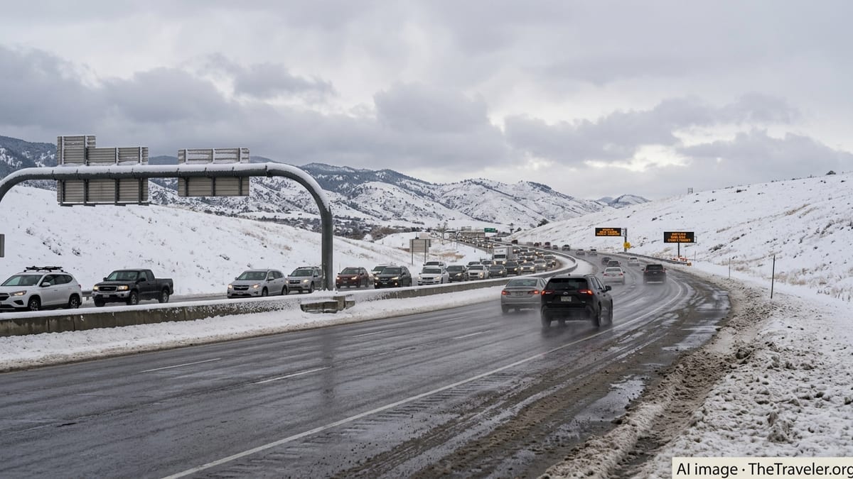
Transportation bulletins and traveler reports describe quickly deteriorating driving conditions across portions of the Front Range, foothills and mountain corridors as snow intensity increases. Slushy and snow‑packed stretches are being noted on segments of Interstate 70 through the foothills, along U.S. 285, and on key approaches to the major mountain passes that connect the metro area with ski country.
State transportation updates emphasize that the combination of a recently warm pavement surface and heavy, wet snow can be deceptive for drivers. Lanes that appear merely wet can transition to a slick mix of slush and ice as temperatures slide toward freezing, particularly overnight and during the coldest hours of the morning. Bridges and overpasses, which cool faster than the surrounding roadway, are especially vulnerable to sudden icing.
Chain and traction requirements are being reported on some higher‑elevation stretches, especially for commercial trucks and vehicles lacking adequate winter tires. Travelers heading over the Continental Divide and through popular resort gateways are being urged, via official bulletins and road‑condition maps, to build in extra time, prepare for sudden slowdowns and carry proper winter equipment even if they are starting their trip from a warm, snow‑free city.
In the metro corridor, local traffic cameras and commuter updates show reduced speeds and intermittent spin‑outs where snow bursts coincide with peak travel times. While major arterials are seeing plow and treatment activity, side streets, neighborhood hills and shaded intersections are likely to remain slick longer, particularly as daytime melting refreezes overnight.
Air Travel, Regional Mobility and Safety Concerns
According to publicly available flight tracking dashboards and airport status boards, the snowfall and shifting winds are contributing to delays and scattered cancellations at Denver International Airport, a critical hub for both domestic and international traffic. Ground crews face the challenge of deicing aircraft, clearing taxiways and managing ramp operations in heavy, wet snow that can quickly clog equipment and slow turnaround times.
Passengers connecting through Denver or originating flights from the Front Range are being advised, in widely shared travel advisories, to monitor airline notifications closely, allow additional time to reach the airport on potentially slick roads, and be prepared for gate or schedule changes as the storm evolves. Even modest operational disruptions in Denver can ripple into delays at other airports across the country.
Regional bus services and intercity shuttles between Denver, Colorado Springs, Fort Collins and the mountain resorts are also experiencing weather‑related slowdowns, with some operators publicly announcing schedule adjustments and urging riders to check for updates before departing. In mountainous terrain, visibility reductions from snow and low clouds may prompt temporary pauses or rerouting for safety.
Public safety messages shared through broadcast outlets and official social channels stress familiar winter precautions: reduce speed, increase following distance, pack warm clothing and emergency supplies in vehicles, and exercise extra caution on untreated or partially treated surfaces. Pedestrians and cyclists are being reminded that slushy crosswalks, icy curb ramps and reduced sightlines can all increase the risk of accidents.
Climate Context and What Comes Next for Colorado Travelers
Climatologists and long‑term records consistently point out that March and April are among Colorado’s snowiest months, even as recent years have delivered increasingly frequent warm spells and record‑setting highs. The current event fits a well‑known pattern of sharp swings between warm, dry days and heavy, wet snow that can arrive with little more than a day of lead time.
Recent climate summaries from regional research institutions describe a broader picture of warmth and dryness across multiple water years, punctuated by intense but episodic storms that deliver large amounts of precipitation over short windows. For travelers and residents alike, this means planning for a wider range of possible conditions, especially during the transitional seasons when sun, rain and heavy snow may all occur within the same week.
Short‑term forecasts suggest that once the core of the storm moves east, skies will gradually clear and temperatures will begin to rebound, aided by Colorado’s strong late‑March sun angle. That same sunshine is likely to melt snow quickly on many paved surfaces, even as shaded areas and higher elevations hold on to their new accumulation longer.
For now, those on the roads and in the air across Colorado are navigating a familiar but still jarring reality: a state where an afternoon in the 60s can be followed almost immediately by a snowstorm bringing several inches of accumulation, travel disruptions and renewed respect for the volatility of spring in the Rockies.