
Lake Superior is one of North America’s most rewarding road trip and adventure destinations, but it can also be one of the most unforgiving. The lake’s vast size, cold water, shifting weather and long distances between services mean that small planning errors can quickly snowball into uncomfortable or even dangerous situations. Avoiding a handful of common mistakes will go a long way toward turning your Lake Superior journey into the memorable experience you imagined.
Underestimating Lake Superior’s Size, Distances and Driving Time
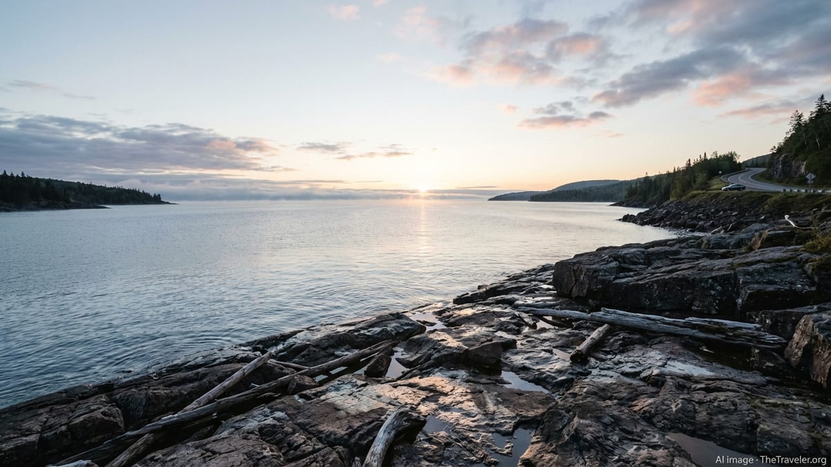
First-time visitors often picture Lake Superior as a large but manageable regional lake rather than an inland sea. In reality, the shore sprawls across three U.S. states and one Canadian province, and the classic Circle Tour route can easily exceed 1,300 miles depending on side trips. Travelers who assume they can “wing it” in a few days frequently end up rushing from town to town, driving long after dark and missing many of the scenic stops that make the region special.
Another common mistake is treating the drive like typical interstate highway travel. Much of the route follows two-lane roads that curve along the shoreline, pass through small communities and traverse stretches of forest and rocky headlands. Wildlife crossings, construction zones and slower local traffic are all routine. What looks like a three-hour drive on a map can easily stretch into four or five, especially in peak summer or during autumn leaf season when viewpoints and small towns are busy.
Because of these factors, building flexibility into your itinerary is crucial. Plan shorter driving days than you think you need, especially if you want to stop for hikes, waterfalls, lighthouses and museums. Give yourself extra buffer time for border crossings and ferry rides, and assume that at least one day will be affected by weather that keeps you off the water or delays your schedule. The more margin you build in, the less likely you are to feel like you are chasing the trip instead of enjoying it.
Overnight logistics deserve the same care. Some stretches of shoreline, particularly on the Canadian side and in parts of Michigan’s Upper Peninsula, have long gaps between larger towns, gas stations and lodging. Waiting until late afternoon to look for a room can leave you driving much farther than you planned, or settling for something far from the lake. Research distances between communities ahead of time, decide where you want to be at the end of each day and reserve in advance during busy seasons.
Misjudging Weather, Seasons and the Lake’s Cold Water
Lake Superior’s weather catches many visitors off guard. The lake’s cold surface moderates the surrounding climate, often keeping shorelines cooler and foggier than inland locations, especially in spring and early summer. Travelers who pack only for warm, sunny days can find themselves shivering in wind off the water, walking in cold drizzle or facing sudden temperature drops when a front passes through. Local authorities in the region routinely remind visitors that conditions can change quickly, with fog, strong winds and waves developing with little notice.
The cold water itself is one of the most important and most overlooked factors. Even in midsummer, average water temperatures remain in the cold range. Agencies such as Parks Canada and the U.S. National Park Service emphasize that the lake’s typical water temperature hovers in the upper 30s to 40s Fahrenheit, a level where hypothermia can develop rapidly for anyone who ends up in the water without proper protection. They highlight guidance such as the “1-10-1” rule for cold water immersion, which notes that you have about one minute to get your breathing under control, around ten minutes of meaningful movement, and roughly an hour before cold becomes life-threatening. This underlines how unforgiving a capsize or unexpected swim can be.
Visitors accustomed to smaller inland lakes may treat Superior like a big swimming hole, venturing far from shore without flotation or wading into rough surf for photos. Safety agencies around the lake, including university police departments and coastal communities, repeatedly warn that strong currents and large waves can be deadly and that rock formations and breakwalls are notorious for dangerous rip currents. Ignoring posted flags, warning signs or lifeguard instructions, or assuming that “it looks fine right now,” are mistakes that have had real consequences in recent years.
Seasonal timing also plays a major role in your experience. Spring can bring dramatic waterfalls and fewer crowds, but water and air remain cold and trails may still be muddy or partially snow covered. Summer offers more reliable warmth and open services, yet biting flies, thunderstorms and heavy traffic on popular weekends can be frustrating if you did not anticipate them. Autumn delivers spectacular colors but shorter days and fast-changing weather. Winter travel can be magical for those prepared for subfreezing temperatures, snow and ice, but it is also the season when road closures, limited services and hazardous shoreline conditions are most pronounced. Assuming the lake behaves like a typical summer resort area is a recipe for disappointment.
Overlooking Water, Hiking and Shoreline Safety
Many of the region’s signature experiences happen near or on the water, from short swims and beach walks to sea kayaking, canoeing and sightseeing cruises. A common mistake is to equate Lake Superior with more benign waters where an unexpected dip is merely inconvenient. In reality, safety agencies on both sides of the border stress that immersion without appropriate thermal protection can lead to rapid loss of coordination and strength. For paddlers and small boat users, failing to wear life jackets, skipping dry suits or wet suits in cold conditions and paddling alone magnify the risks significantly.
Even staying on shore presents hazards that many travelers underestimate. University and municipal safety advisories for popular beaches around the lake note that rip currents are common near certain rock outcrops and breakwalls. Waves that look thrilling from a distance can sweep people off piers or jetties, dragging them into turbulent water. Climbers on wet rocks near waterfalls or along steep headlands can slip quickly, and rescue may take time in remote areas. Choosing dramatic photo angles or cliff edges without thinking through the consequences is an all-too-common misstep.
Hikers also sometimes treat Lake Superior’s backcountry trails like short in-town walks, neglecting to carry proper footwear, layers, water and navigation tools. National and provincial park staff emphasize that weather can deteriorate abruptly, leaving unprepared hikers cold, wet and disoriented. In parks such as Pukaskwa and on wild stretches of coast, visitors are advised to register before backcountry trips, carry detailed maps and understand that fog or storms can limit visibility for days. Relying solely on smartphone maps or assuming that cell coverage will always be available are planning errors that can compound quickly if you make a wrong turn.
The best safeguard is to adopt a “big water” mindset whenever you are near the lake. Wear a properly fitted life jacket when boating or paddling, dress for the water temperature rather than the air, and stay well back from the edge during powerful wave events. On trails, treat even short hikes as real excursions by bringing water, a basic first-aid kit, extra layers and a paper map or compass. Respect barriers and warning signs at overlooks, waterfalls and cliff edges, and resist the temptation to climb over them for a better photo.
Not Accounting for Limited Services, Connectivity and Cross-Border Logistics
Another frequent surprise for Lake Superior travelers is how quickly you can transition from a busy harbor town to long stretches of forest-lined road with little development. Fuel, groceries, restaurants and even cellular coverage can be sparse in these areas. Drivers who let their gas tanks drop too low or assume they can always find a cafe by the next bend may find themselves anxiously watching the fuel gauge. Likewise, travelers who assume constant mobile data access can get caught without offline maps or the ability to check weather alerts and road conditions when they may need them most.
Planning a full Circle Tour introduces additional layers of complexity, particularly at the international border between the United States and Canada. While the main crossings near Sault Ste. Marie and Thunder Bay operate regularly, traffic can back up during busy seasons, and processing takes time. Travel writers and regional magazines note that it is not uncommon to wait on bridges or in queues for significant periods, sometimes in hot sun or muggy conditions. Visitors who do not carry enough water, forget to use restrooms before entering a slow-moving line or neglect to fill the fuel tank can find the process more stressful than it needs to be.
Documentation is another area where oversights are common. A passport or approved travel document is required for crossing the border, and each country has its own rules for items such as food, alcohol and outdoor equipment. Travelers sometimes assume that the rules they remember from a past visit still apply or that friendly agents will overlook minor violations. In reality, policies and screening procedures can change, and unexpected confiscations or delays at customs can derail tightly timed itineraries.
To avoid these pitfalls, download offline maps, travel apps or guide information before you leave strong signal areas, and bring printed confirmations of key reservations. Keep your fuel tank at least half full in remote stretches, and carry snacks and drinking water in the vehicle. If you plan to cross the border, verify documentation and customs regulations well before departure, and build plenty of buffer into your schedule so that a longer-than-expected line does not force you to skip a planned hike or scenic detour.
Being Unprepared for Wildlife, Road Hazards and Driving Conditions
Driving around Lake Superior offers exceptional scenery, but it also comes with unique hazards that many visitors underestimate. Wildlife is a constant presence, and regional travel accounts frequently mention encounters with deer, moose, foxes and even bears along the roadside. Large animals can appear suddenly, especially at dawn and dusk, and collisions can be serious. Drivers unused to watching the edges of forested highways closely sometimes carry too much speed into dimly lit stretches, reducing their ability to react.
Road conditions themselves can vary widely with the season. In summer, heavy tourist traffic, construction zones and slow-moving recreational vehicles can lead to sudden backups or risky passing attempts by impatient drivers. In shoulder seasons and winter, rain, sleet, snow and black ice are all possible, particularly in higher elevations and near exposed stretches of shoreline. Short, intense storms rolling off the lake can drastically reduce visibility, and fog advisories for portions of Lake Superior are common in warmer months as cold water interacts with humid air.
Motorcyclists and cyclists on the Circle Tour face their own set of challenges. Travel features about riding the loop emphasize the importance of being prepared for long distances between services, strong crosswinds in open areas and fatigue from hours on winding two-lane roads. Gravel patches, frost heaves and debris from storms can appear without warning. Riders who do not factor in these conditions, or who overestimate how many miles they can comfortably complete in a day, may find the experience more exhausting than enjoyable.
The safest approach is to treat every day’s drive as a scenic journey rather than a race. Slow down in areas with wildlife warning signs and dense forest, and avoid driving during peak animal movement times if possible. Check road and weather forecasts each morning, and be willing to adjust plans if conditions deteriorate. Ensure your vehicle or bike is in good mechanical condition, carry an emergency kit and keep someone at home informed of your route, especially if you will be traveling for long stretches without reliable cell coverage.
Ignoring Local Advice, Regulations and Environmental Impact
Local knowledge is one of the most valuable resources a Lake Superior traveler can tap into, yet many visitors either overlook it or actively ignore it. Park rangers, visitor center staff, marina operators and long-time residents all have firsthand experience with the lake’s moods, seasonal patterns and hidden hazards. When they recommend avoiding certain rock formations in rough surf, advise extra layers on a seemingly mild day or suggest alternative routes because of construction or wildlife, they are drawing on years of observation. Brushing off that advice as overly cautious can lead to avoidable trouble.
Regulations are another area where complacency creates problems. Rules about campfire locations, backcountry permits, food storage and boating lanes are not arbitrary. They are designed to protect both visitors and the fragile coastal ecosystems that make the lake so attractive. Cutting across vegetated dunes to reach a beach more quickly, ignoring posted closures or feeding wildlife for close-up photos all have cumulative impacts. They can accelerate erosion, habituate animals to human food and strain limited park resources.
Environmental awareness matters particularly around Lake Superior because so much of its appeal lies in its wild character and relatively clean waters. Travelers who leave trash on beaches, fail to pack out what they carry in or wash dishes in small streams contribute, even unintentionally, to degrading the experience for everyone. With more attention on the Great Lakes in recent years and evidence of changing ice cover and shifting seasonal patterns, local researchers and managers are acutely aware of how visitor behavior interacts with broader environmental pressures.
Respecting guidelines such as “leave no trace,” obeying signage and participating in local conservation efforts where possible are simple ways to give back to the region you are enjoying. Take advantage of ranger talks, community bulletin boards and local newspapers to stay informed about current conditions, temporary closures or cultural events. Treat your interactions with the landscape as a partnership rather than a one-sided consumption of views and amenities.
The Takeaway
Planning a trip to Lake Superior is an invitation to experience one of the most distinctive freshwater environments in the world. Its scale, weather and remoteness are part of its magic, but they also demand a level of respect and preparation that some travelers underestimate. Common missteps such as rushing the route, underpacking for the weather, treating the water casually or assuming services will always be close at hand can all erode the enjoyment of your journey.
By approaching the lake as an inland sea rather than a typical vacation lake, you set a more realistic baseline for your plans. Build flexibility into your schedule, prepare for cold water and fast-changing weather, heed local advice and be deliberate about safety on roads, trails and shorelines. The reward is a trip where the surprises are the good kind: an unexpected rainbow over a harbor town, a quiet sunset on an empty beach or a clear night sky alive with stars. With thoughtful planning and respect for the big lake’s power, your Lake Superior adventure can live up to the stories you will tell about it for years to come.
FAQ
Q1. How many days should I plan for a Lake Superior Circle Tour?
Most travelers find that 7 to 10 days allows a comfortable pace with time for sightseeing, though adding extra days is wise if you enjoy hiking or paddling.
Q2. Is it safe to swim in Lake Superior in summer?
Swimming can be enjoyable on warm days near shore, but the water remains cold, so staying close to shore, watching for waves and currents and exiting if you feel chilled are essential.
Q3. Do I really need a wet suit or dry suit for kayaking?
For paddling on the open lake or away from sheltered bays, a wet suit or dry suit is strongly recommended because of the cold water and the risk of rapid hypothermia if you capsize.
Q4. How bad is cell phone coverage around the lake?
Certain stretches, especially in remote Canadian sections and forested areas, have spotty or no coverage, so downloading offline maps and not relying on constant signal is important.
Q5. What is the best time of year to visit Lake Superior?
Summer offers the warmest conditions and the most services, while late spring and autumn provide fewer crowds and beautiful scenery but more variable weather and cooler temperatures.
Q6. Are there special safety concerns at Lake Superior beaches?
Yes. Strong currents, cold water and powerful waves can all be hazardous, particularly near rock formations and breakwalls, so obey warning signs and follow local safety guidance.
Q7. How should I prepare for driving conditions on the Circle Tour?
Expect two-lane roads, wildlife crossings and changing weather, plan shorter driving days than on interstates and keep your gas tank and emergency supplies topped up.
Q8. What documents do I need to cross between the United States and Canada?
Adults generally need a valid passport or approved travel document, and it is wise to check current border and customs requirements before your trip.
Q9. Can I complete the trip without advance reservations?
In shoulder seasons it may be possible, but in summer and during busy holiday or fall color periods, booking lodging and popular campgrounds in advance is strongly recommended.
Q10. How can I minimize my environmental impact while visiting?
Follow leave-no-trace principles, respect closures, stay on established trails, pack out all waste and support local businesses and conservation initiatives when you can.