
More news on this day
Travelers chasing North America’s most dramatic landscapes are increasingly looking beyond Arizona’s Grand Canyon to Mexico’s Copper Canyon, a sprawling chasm network estimated at four times larger in area.
Get the latest news straight to your inbox!
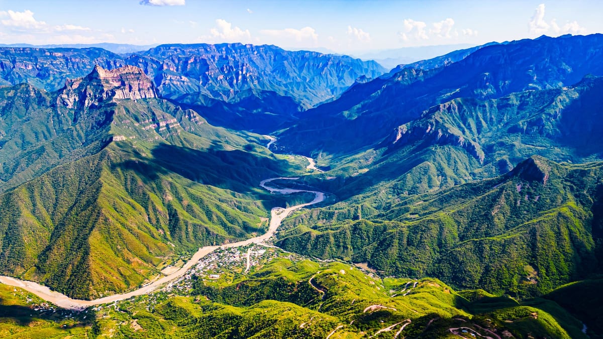
Image by TheTravel
A Canyon System That Dwarfs Arizona’s Icon
Publicly available geographic data and travel coverage describe Copper Canyon, or Barrancas del Cobre, as a linked system of six main canyons carved into the Sierra Madre Occidental in the Mexican state of Chihuahua. Together, these ravines sprawl across roughly 25,000 square miles, compared with about 6,000 to 7,000 square miles often cited for the Grand Canyon region.
While Arizona’s Grand Canyon measures about 277 miles in length, Copper Canyon’s combined chasms extend over a broader mountain plateau and occupy around a third of Chihuahua, Mexico’s largest state. Some individual gorges in the system drop more than 6,000 feet from rim to river, placing the deepest sections roughly 1,000 feet lower than the Colorado River corridor in Arizona.
The result is a landscape that feels more like an entire mountain province of ravines than a single canyon. Travelers arriving for the first time often encounter not one view but a succession of vast amphitheaters, side canyons, and cliff walls that run far beyond the frame of a typical viewpoint photograph.
Unlike the comparatively uniform rock palette of northern Arizona, Copper Canyon takes its name from the copper and green mineral stains that wash across its volcanic walls. Reports from recent visitors describe cliffs that seem to change color with the sun, shifting from pale gold in the morning to deep rust and forest green as evening approaches.
Remote Villages, Living Culture, and High-Elevation Rail
Beyond its statistics, Copper Canyon stands out for the communities that have long called it home. Public information highlights the presence of the Rarámuri, or Tarahumara, an Indigenous people known for endurance running traditions and for maintaining settlements perched on canyon rims and tucked into side valleys.
Instead of large gateway towns and highway loops, access into the Mexican canyon network often passes through small mountain villages, family-run guesthouses, and local markets. This disperses tourism across a wider region and means visitors are more likely to encounter working ranches, subsistence farms, and everyday life unfolding on canyon terraces.
One of the most distinctive features of the region is the Ferrocarril Chihuahua al Pacífico, commonly called El Chepe, a passenger rail line that runs between the city of Chihuahua and the Pacific port of Los Mochis. Travel coverage describes the journey as one of North America’s most dramatic train rides, threading dozens of tunnels and bridges as it climbs and descends through the canyons.
Stations such as Creel and Divisadero function as key jumping-off points for viewpoints, hiking routes, and canyon-edge lodges. Unlike the road-based visitation model around the Grand Canyon’s South Rim, many Copper Canyon itineraries still revolve around the rhythm of the train schedule, which shapes how tourists move and where they linger.
Adventure Tourism Without the National Park Crowds
In recent years, Mexican tourism promotion has highlighted Copper Canyon as a quieter alternative for travelers seeking Grand Canyon-scale scenery without peak-season congestion. Compared with Arizona’s national park infrastructure, the Copper Canyon region remains relatively lightly developed, with fewer paved viewpoints and less dense hotel clusters.
Available visitor reports describe a growing range of adventure options, from guided hiking and horseback trips to mountain biking routes and multi-day treks that connect canyon villages. In several locations, zipline circuits and an aerial tramway span high above the ravines, offering access to viewpoints that once required full-day hikes.
This lighter footprint brings trade-offs. Road conditions can vary, public transport between smaller settlements is limited, and many trails are unsigned, making local guides an important part of safe trip planning. For experienced travelers, however, that same lack of heavy infrastructure is part of the appeal, allowing long vistas and night skies largely free of artificial light.
Safety considerations remain an important factor, as Chihuahua has seen fluctuating levels of crime in recent years. Travel advisories urge visitors to check current guidance, work with reputable operators, and focus on established tourism hubs, especially when moving beyond the main rail corridor.
Climate, Seasons, and How Copper Canyon Compares
Copper Canyon’s elevation range creates sharper climatic contrasts than many first-time visitors expect. Higher rim towns can experience cool winters, even light snow, while canyon bottoms trend subtropical, with warmer temperatures and, at times, increased humidity. Seasonal rains typically green the slopes and feed waterfalls that rarely appear in the Grand Canyon’s arid setting.
During the dry months, usually late autumn through early spring, visibility tends to be clearer and temperatures more comfortable for hiking at mid-elevations. The summer rainy season brings more dramatic skies, fuller rivers, and cascades, though trails can become slippery and some backcountry routes less predictable.
Side-by-side, the Grand Canyon often wins for ease of access, extensive signage, and a well-established network of campgrounds and visitor centers. Copper Canyon, on the other hand, offers scale and depth on par with or greater than Arizona’s showpiece, layered with active rail travel, inhabited settlements deep within the ravines, and a sense of geographic isolation that is harder to find along a busy national park rim.
For travelers willing to trade familiar viewpoints for a more complex journey, the Mexican canyon system provides an alternative definition of “grand” that stretches far beyond a single overlook on the Colorado Plateau.