
More news on this day
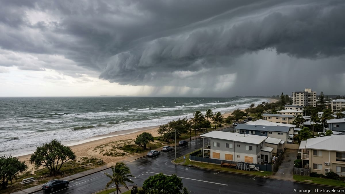
Queensland is on high alert as Severe Tropical Cyclone Narelle, now at category five intensity in the Coral Sea, tracks towards the state with forecasts indicating a rare triple landfall threat and the potential for destructive winds, life-threatening flooding and prolonged disruption across a wide stretch of the coast.
Get the latest news straight to your inbox!
Category Five System Intensifies in the Coral Sea
Publicly available information from the Australian Bureau of Meteorology indicates that Narelle formed in the eastern Coral Sea in mid-March before rapidly intensifying over very warm waters and favourable atmospheric conditions. The cyclone has since strengthened into a severe system, with sustained winds estimated above 200 kilometres per hour and higher gusts near the core.
Forecast guidance compiled in regional cyclone outlooks shows Narelle as one of the strongest systems of the 2025–26 Australian cyclone season to date, rivaling recent high-impact storms in the basin. Satellite imagery shared in current coverage depicts a large, well-defined eye and deep convective bands, consistent with a powerful, well-organised cyclone.
Meteorological summaries describe an expansive wind field, meaning damaging conditions are expected to extend far from the eye. This increases the likelihood that coastal communities will experience hazardous weather even if they are not in the direct path of the centre.
Rare Triple Landfall Scenario Emerges
Updated track maps issued for Queensland indicate that Narelle could take a looping or recurving path close to the coastline, raising the prospect of three separate landfall or near-landfall events over several days. This kind of complex motion has been recorded only occasionally in the Australian region, and it significantly complicates risk planning.
According to current projections, the cyclone may first brush or cross the coastal fringe of the far northern or central coast, then move back over water, maintaining cyclone strength, before curving again towards the shoreline further south. Each approach carries the potential for renewed destructive winds, storm surge and intense rainfall in overlapping areas.
Analysts following the official guidance note that even relatively minor changes in steering winds could shift the zones of greatest impact by hundreds of kilometres. As a result, a broad section of Queensland’s coast, including tourism centres, regional hubs and smaller outlying communities, is being urged through public messaging to prepare for an extended period of hazardous conditions rather than a single short-lived event.
Heavy Rain, Storm Surge and Flooding Risks for Coastal Communities
Hydrological outlooks and coastal impact assessments highlight heavy rain and freshwater flooding as one of the most serious concerns associated with Narelle. A slow-moving or looping cyclone can deliver repeated bursts of intense rainfall, greatly increasing the chance of river flooding, flash flooding in urban areas and landslides in hilly terrain.
Coastal hazard statements referenced in media coverage emphasize the risk of storm surge combining with high tides, particularly if landfall coincides with peak water levels. Low-lying coastal suburbs, river mouths and estuaries could face inundation, coastal erosion and damage to marinas, waterfront infrastructure and beachside properties.
Travel-focused reporting notes that roads in flood-prone valleys, bridges across major rivers and key highway links to tourist destinations may be disrupted during and after the cyclone. Prolonged power outages, interruptions to mobile coverage and reduced access to fuel and supplies in smaller communities are also being highlighted as likely secondary impacts if Narelle’s triple landfall scenario unfolds.
Queensland Tourism Belt Braces for Disruption
From the tropical north to the popular islands and beaches of central and southern Queensland, the cyclone’s projected path runs through some of Australia’s most visited holiday regions. Resort operators, caravan parks and tour providers are closely monitoring public information channels as they adjust bookings, plan for early departures and secure exposed infrastructure.
Airlines and travel providers have begun flagging the possibility of schedule changes at coastal airports, while ferry and cruise operations in the Coral Sea and along the Great Barrier Reef are under review for potential suspension if conditions deteriorate. According to coverage in national and regional outlets, visitors are being encouraged to stay informed through official warning services and to follow local advice on shelter and movement.
Travel insurers and accommodation providers are expected to experience a spike in inquiries, as travellers reassess itineraries that include island resorts, reef excursions and coastal road trips. Industry observers caution that even areas ultimately spared from direct wind damage may face days of transport disruption, hazardous seas and limited access to marine-based attractions.
Preparedness Messages Focus on Extended Hazard Period
Emergency management briefings and publicly shared planning documents for Queensland stress the importance of preparing for an extended period of adverse weather rather than a single peak of impact. Households along the projected track are being advised through broad public messaging to secure loose items, check drainage around properties and ensure access to essential supplies in case roads are cut or services are disrupted.
Regional councils and state agencies are updating flood mapping, reviewing evacuation route signage and considering the implications of repeated coastal impacts if Narelle returns to sea between landfalls. Infrastructure such as power networks, ports and critical transport corridors is being prioritised in readiness planning due to the potential for compound damage over multiple encounters with the system.
For travellers currently in Queensland or planning imminent trips, widely shared guidance recommends closely tracking official warnings, confirming arrangements with transport and accommodation providers and allowing for itinerary flexibility. With Narelle continuing to evolve and the triple landfall scenario still subject to change, forecasters and analysts emphasise that the cyclone’s impacts may extend well beyond its core, with conditions along the Queensland coast likely to remain hazardous for several days.