
More news on this day
Severe Tropical Cyclone Narelle is unleashing intense rainfall and dangerous flooding across parts of Australia’s Northern Territory, with rapidly rising rivers, expanding evacuation zones and widespread transport disruption creating an increasingly volatile situation for residents and travellers.
Get the latest news straight to your inbox!
Rapidly Escalating Flood Threat Across the Top End
Publicly available information on the 2025–26 Australian cyclone season shows Cyclone Narelle reached Category 5 intensity over warm Coral Sea waters before making initial landfall in far north Queensland and then tracking west into the Gulf of Carpentaria. As the system moved inland and weakened, its vast rain bands spread across parts of the Northern Territory, feeding multiple days of intense downpours over already saturated catchments.
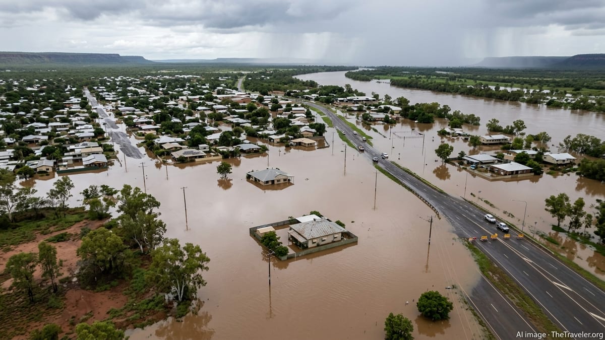
Forecast discussions and live coverage indicate that Narelle’s remnant core has stalled and slowed at times over inland areas, a pattern that significantly increases the risk of prolonged, high‑volume rainfall. In river systems that were already running high from earlier wet season events, the additional water is pushing levels toward or above major flood thresholds, particularly in low‑lying communities, pastoral districts and along key transport corridors.
Emergency mapping and flood bulletins point to a complex mix of riverine flooding from major waterways and fast‑moving flash flooding across creeks and urban stormwater systems. With soils unable to absorb further rain, runoff is moving quickly into rivers and across roads, cutting access to some communities with little warning.
In the Katherine region and parts of the Daly and Roper catchments, river height forecasts describe potential peaks consistent with previous historic flood events. Hydrologists are warning that the combined effect of upstream rainfall, local thunderstorms and ongoing inflows could keep floodwaters elevated for days even after Narelle’s circulation finally weakens and moves away.
Communities Evacuated as Rivers Rise Toward Major Levels
According to Northern Territory government updates and national media coverage, evacuations have been stepped up in several at‑risk communities as Narelle‑driven floodwaters spread across the landscape. Low‑lying neighbourhoods near major rivers, outstations, and remote Aboriginal communities are among the hardest hit, with some residents moved pre‑emptively before access roads become impassable.
Public bulletins describe a multi‑stage approach to evacuations, starting with voluntary relocations for residents in flood‑prone streets and caravan parks, followed by organised transfers from communities where river forecasts point to dangerously high peaks. In some areas, evacuation centres further inland or on higher ground are being readied to receive people for what may be an extended stay if infrastructure damage is severe.
Reports from the Katherine district and other regional hubs indicate that some residents who were affected by previous flood events in recent years are again facing difficult decisions about when to leave and what to take. Local news coverage highlights concerns about the safety of vulnerable residents, including older people, people with disabilities and those reliant on regular medical care, as access to clinics and pharmacies is disrupted by inundated roads.
State and federal disaster agencies are publicly flagging that evacuation operations may need to expand rapidly if Narelle’s rain bands persist or shift unexpectedly. Contingency planning is focusing on the possibility of multiple communities requiring simultaneous evacuation support, stretching available transport and accommodation capacity across the Top End.
Air, Road and Rail Networks Suffer Widespread Disruption
Travel conditions across the Northern Territory and adjacent parts of Queensland have deteriorated sharply as Cyclone Narelle’s impacts spread, with published travel advisories warning of extensive delays and cancellations. Major highways, including sections of long‑distance tourist routes, are affected by floodwater covering the carriageway, damaged pavement and debris washed across the road surface.
Transport agency updates show partial or full closures on key routes linking Darwin, Katherine and the Gulf communities, as well as on smaller outback roads used by four‑wheel‑drive travellers and tour operators. Even where roads remain technically open, authorities are urging extreme caution, with reports indicating rapidly changing water depths, hidden potholes and sections where shoulders have been eroded away.
Regional aviation has also been heavily disrupted. Flight information from domestic airlines and airport operators points to cancellations and schedule changes at several Northern Territory airports, particularly where crosswinds and reduced visibility make safe operations difficult. Airstrips in smaller communities have become unusable in some cases due to standing water and soft ground, limiting options for charter flights, medical evacuations and supply runs.
Rail freight corridors that carry essential goods into the Territory have been affected by inundated track sections and landslips in known trouble spots. Logistics firms and freight operators are reporting delays as trains are rerouted or held back until engineers can inspect and certify damaged sections of line. These disruptions are already affecting the movement of fuel, food and building materials into some regional centres.
Tourism and Remote Travel Plans Upended
For travellers, Cyclone Narelle has arrived at a critical time of year when many domestic and international visitors are moving through northern Australia. Travel industry reports indicate that tours to popular nature destinations, remote lodges and cultural sites across the Top End have been suspended or significantly curtailed, both for safety reasons and due to access roads being cut.
Operators in regions near the Gulf of Carpentaria and across the inland floodplain are advising that itineraries may need to be rewritten at very short notice, with some switching to last‑minute alternatives in less‑affected areas. Published commentary from tourism bodies emphasises that many iconic natural attractions, including gorges, waterfalls and national park campgrounds, are vulnerable not only to flooding but also to rockfalls, shoreline erosion and fallen trees.
Hotel and accommodation booking platforms are recording a wave of cancellations and date changes in the days following Narelle’s intensification, particularly in regional hubs that serve as gateways to remote experiences. At the same time, some motels and caravan parks on higher ground are housing evacuees and emergency workers, reducing availability for passing tourists.
Travel insurers and consumer groups are reminding visitors to review policy wording closely, as coverage for cyclone‑related cancellations and delays varies between providers. Publicly available advice stresses the importance of documenting disrupted plans and keeping receipts for alternative accommodation and transport where possible.
Safety Guidance for Travellers in an Unstable Weather Pattern
National meteorological guidance and disaster management briefings describe Cyclone Narelle as part of a broader pattern of higher‑risk weather over northern Australia this wet season, with saturated catchments and above‑average rainfall increasing the likelihood of further flooding even after the current system weakens. For travellers, this means that conditions can change quickly over a wide area, sometimes far from the cyclone’s centre.
Travel advisories recommend that anyone currently in, or planning to visit, the Northern Territory and adjacent Gulf and Cape regions maintain close attention to official weather warnings and local council updates. Public information highlights the need to avoid driving or walking through floodwaters, to respect road‑closure barriers, and to prepare for delays that may last longer than expected if infrastructure damage is extensive.
Visitors undertaking long outback drives are being encouraged to carry extra water, food and fuel, along with a means of communication that can function if mobile coverage is disrupted. Guides for remote travel in Australia also recommend registering trip intentions with local visitor centres or online platforms, so that someone is aware of planned movements in case roads close suddenly.
As Cyclone Narelle continues to unfold, the full extent of its impact on the Northern Territory’s communities, infrastructure and tourism industry will only become clear over the coming days. For now, publicly available information makes clear that caution, flexibility and careful attention to local conditions are essential for anyone travelling through the region.