
More news on this day
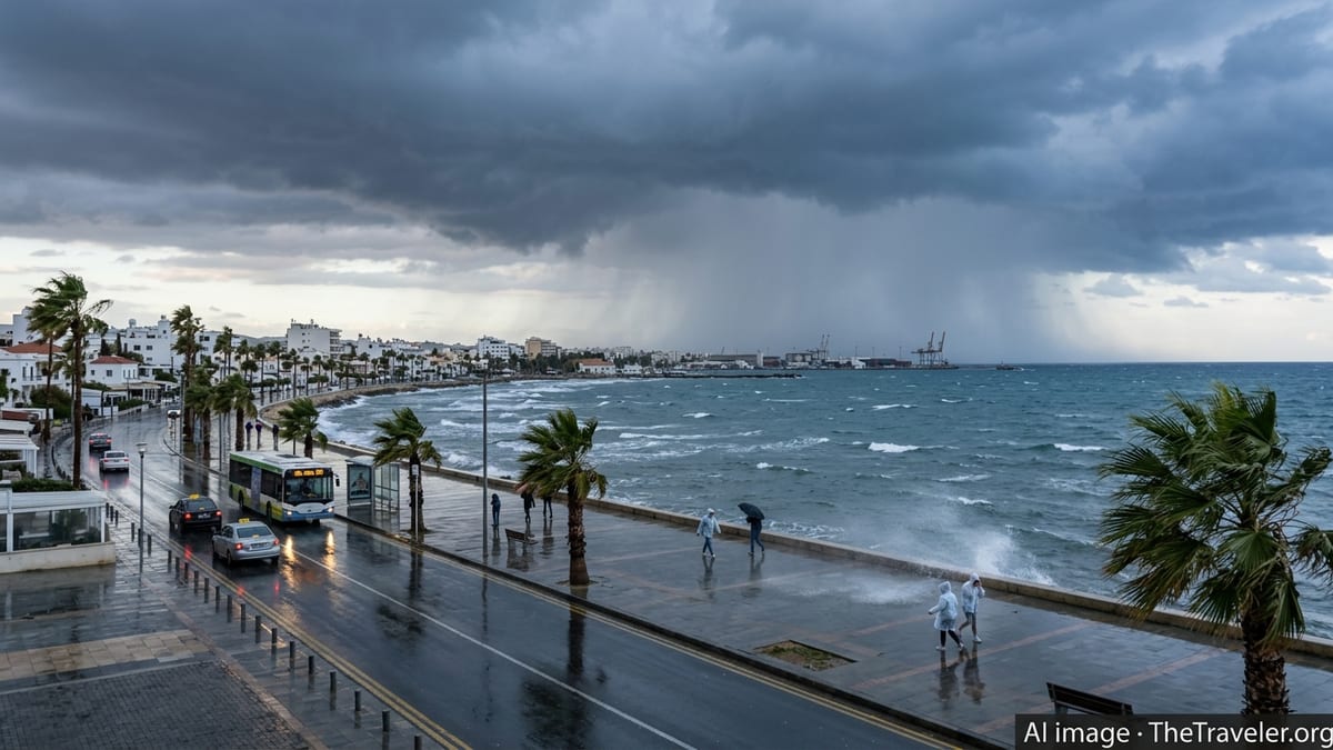
Cyprus is bracing for an intense spell of severe weather, with island-wide storm alerts in force and forecasters warning of heavy rain, thunderstorms, strong winds, and local flooding that are expected to disrupt air travel, road networks, and popular tourist activities over the coming days.
Get the latest news straight to your inbox!
Severe Weather System Targets Cyprus
Publicly available forecasts from the Cyprus Department of Meteorology indicate that a vigorous low-pressure system over the eastern Mediterranean is drawing unstable, moisture-laden air across the island, creating ideal conditions for powerful thunderstorms and prolonged downpours. Recent regional weather coverage links the pattern to the same broader trough that has fueled unsettled conditions across parts of the Mediterranean through late March.
Yellow-level storm warnings currently highlight the risk of intense rainfall, hail, lightning, and gusty winds over much of Cyprus, including coastal areas and higher ground. Meteorologists expect the heaviest activity to occur in bursts, with sudden squalls, sharp drops in visibility, and rapid accumulations of water on roads and in built-up areas.
The timing of the storm coincides with a busy period for inbound leisure travel, heightening concerns about disruption to flights serving Larnaca and Paphos airports, as well as organized tours and outdoor excursions. Travel industry updates describe operators moving quickly to review itineraries and adjust schedules in anticipation of weather-related delays.
Forecast discussion suggests that the most hazardous conditions could persist through at least the next 24 to 36 hours, with further updates expected as the system evolves. Travelers already on the island are being advised through public channels to closely monitor official bulletins and local media reports.
Flight Operations at Larnaca and Paphos Under Pressure
According to published information from aviation tracking platforms and local media coverage, airlines serving Larnaca and Paphos are preparing for possible delays, schedule changes, and occasional diversions as the storm approaches. Low cloud ceilings, wind shear, and intense rainfall can all slow arrivals and departures, forcing crews to extend holding patterns or reroute aircraft to nearby alternates when safe landing conditions are not assured.
Ground operations are also vulnerable, with strong gusts and standing water on aprons hampering baggage handling, refueling, and boarding. Industry reports from similar storm episodes in Cyprus in recent years show that even when runways remain open, turnaround times can lengthen significantly, triggering knock-on delays across the network.
Travelers flying into or out of Cyprus over the alert period are being urged in publicly available advisories to check flight status frequently and build extra time into transfers. Airlines commonly respond to such events by issuing flexible rebooking options, though policies differ by carrier and fare type.
Airport information channels are emphasizing that safety protocols take priority over punctuality when thunderstorms and crosswinds affect approach paths. While complete airport closures are not currently indicated in the forecasts, aviation observers note that conditions may change rapidly if storm cells intensify directly over key hubs.
Hazardous Road Conditions and Local Transport Disruptions
Recent local coverage of weather-related incidents in Cyprus highlights how fast-changing conditions can impact the island’s road network, particularly in urban centers such as Nicosia, Limassol, Larnaca, and Paphos, and on mountain routes leading into the Troodos range. Heavy downpours have been known to cause flash flooding in low-lying streets, overwhelm drainage systems, and trigger rockfalls or minor landslides on steep terrain.
Public traffic updates frequently warn that reduced visibility from torrential rain, waterlogged surfaces, and wind-blown debris can significantly raise the risk of accidents. Mountain roads, popular with visitors heading to traditional villages and nature trails, may become especially treacherous if hail or wet snow mixes with rain at higher elevations.
Local bus and coach services, including those linking major resorts with airports and inland attractions, are likely to experience slower journeys and potential route adjustments. Tour operators that rely on tight timetables for multi-stop excursions could face cascading delays if convective storms flare during peak travel hours.
Authorities have previously urged drivers in comparable weather situations to avoid unnecessary journeys, keep speeds low, and never attempt to cross flooded sections of road. While no widespread closures have been listed so far in publicly available bulletins, transport observers caution that targeted restrictions are possible if flooding hotspots reappear.
Impact on Outdoor Tourism, Beaches, and Cultural Sites
The approaching storm is expected to cut across many of the outdoor experiences that draw visitors to Cyprus in late March, from coastal promenades and beach clubs to yacht charters, diving excursions, and hiking routes. Tourism-focused weather briefings note that strong onshore winds and rough seas could prompt temporary suspensions of small-boat operations, particularly along exposed stretches of the south and west coasts.
Beachfront businesses may scale back services as conditions deteriorate, removing umbrellas and light structures to reduce the risk of wind damage. Lifeguard coverage on organized beaches, where already available for the season, is likely to focus on keeping visitors away from high surf and strong currents while storms are active.
Inland, popular heritage and cultural sites that involve extensive outdoor walking, such as archaeological parks and open-air museums, could also be affected by slippery surfaces, pooling water, and sporadic closures of certain paths or viewing areas. Tour groups may opt for shorter visits or rescheduled departures to avoid the worst of the weather.
Travel planners emphasize that many indoor attractions, including museums, galleries, and historic churches, remain accessible and can offer alternative experiences during periods of heavy rain. However, visitors are encouraged to verify opening hours on the day of travel, as staffing and safety checks can be influenced by severe weather.
Guidance for Travelers Currently on the Island
Travel advisories aimed at international visitors stress the importance of flexibility and preparedness while the storm warning is in place. Recommended precautions in recent Mediterranean weather events include keeping mobile devices fully charged, storing airline and accommodation details offline, and maintaining access to local news and official alert channels.
Travel risk specialists typically advise packing lightweight waterproof layers, sturdy footwear with good grip, and dry bags for electronics when moving around during intense rain. For those renting vehicles, familiarizing themselves with alternative routes and parking on higher ground away from flood-prone spots can reduce exposure to sudden flash flooding.
Visitors booked on organized tours, cruises, or activities are encouraged by publicly available guidance to stay in close contact with their providers, who are likely to adjust departure times, routes, or group sizes in response to evolving conditions. Many operators now post same-day updates on social channels and messaging apps, outlining any changes to plans.
While the current alerts have raised the prospect of notable disruption, forecasters also point out that Mediterranean storm systems can move through relatively quickly, with marked improvements once the main front passes. For now, travelers across Cyprus are being urged through open information channels to remain cautious, allow extra time for journeys, and be ready for last-minute changes until the severe weather risk eases.