
More news on this day
As a record-breaking March heatwave bakes the central United States, Powell County has joined a growing list of jurisdictions in Colorado, Nebraska, Oklahoma and Texas where early season wildfires are emerging under a volatile mix of extreme temperatures, strong winds and critically low humidity.
Get the latest news straight to your inbox!
Record March Heat Fuels an Early Fire Season
Publicly available weather analyses describe a rare early season heatwave stretching from the Rockies across the central Plains, pushing temperatures 20 degrees or more above normal in several states. Denver, Grand Island in Nebraska and Midland in Texas all registered new March records, with some locations in the Plains approaching or reaching the upper 90s Fahrenheit. These conditions are arriving weeks before the traditional peak of Great Plains fire activity, rapidly eroding what remained of winter moisture.
Forecasters and climate analysts characterize the event as statistically exceptional for March, pointing to a combination of lingering drought, unusually warm winter conditions and strong downslope winds off the Rockies. In parts of Colorado and neighboring states, this pattern has produced what meteorologists describe as a “perfect setup” for wind driven grass and brush fires, even in areas that would normally still be transitioning out of winter.
Across eastern New Mexico and the Texas High Plains, television forecasts and regional briefings highlight strings of record or near record high temperatures around Lubbock and surrounding communities. One local outlet reported an all time March record high in the upper 90s for the city, followed by only a brief cooldown before readings were expected to return to the same dangerous territory. The combination of intense heat, single digit relative humidity and ongoing drought has prompted repeated fire weather alerts.
In this environment, counties such as Powell, El Paso and others in the corridor from Colorado through Nebraska and into the southern Plains are seeing fire danger spike far earlier than residents typically expect. Fire managers in multiple states have been warning for weeks that if the pattern persisted into late March and April, early wildfires could become more frequent and more intense.
Nebraska’s Morrill Fire Highlights the New Risks
Nebraska has already provided a stark example of what these conditions can produce. The Morrill Fire, burning across parts of the Sandhills including Keith, Arthur, Grant, Garden and Morrill counties, has been documented as the largest single wildfire in the state’s recorded history. Official summaries indicate that the blaze ignited on March 12 and eventually burned more than 640,000 acres before containment was reported later in the month.
Satellite imagery, incident reporting and local coverage show huge swaths of rangeland and pasture blackened by the fire, which spread quickly through cured grasses under powerful winds. Air quality monitors and regional reports describe smoke spreading over much of western and central Nebraska, with haze and degraded visibility observed as far as northern Colorado and northwestern Kansas at the height of the event.
The scope of the damage has drawn attention not only because of the acreage involved but also due to the timing. The fire erupted during what is still technically late winter, on the heels of an unusually warm and dry season that left the Sandhills exposed. State agriculture officials have issued public guidance on aid programs and replacement feed for affected ranchers, emphasizing that many operations lost grazing land, fencing and other infrastructure in a matter of days.
While investigators continue to examine the specific ignition causes behind the Morrill Fire and other recent blazes in Nebraska, the rapid rate of spread has been widely linked to the broader weather pattern impacting the region. Forecast products issued in February already noted elevated fire potential across the Nebraska Panhandle and adjacent areas of Colorado and Wyoming heading into March, suggesting that the landscape was primed for a large event once a spark appeared.
Powell County and the Central Plains on Edge
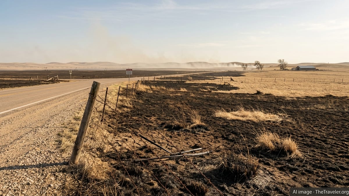
As attention has focused on Nebraska, Powell County and other central Plains jurisdictions have been placed under repeated red flag warnings and elevated fire danger outlooks. Regional predictive services have mapped out a corridor of above normal significant fire potential extending from southeastern Colorado across western Kansas into parts of Nebraska, driven by persistent warmth, low humidity and gusty winds.
Reports from Colorado and nearby states describe a pattern of warm, dry downslope winds sweeping out of the Rockies, sending temperatures in some Front Range communities into the 70s and 80s while rapidly drying fine fuels such as grass and light brush. In several counties, including Powell, officials have relied on preexisting burn restrictions and fire weather protocols to discourage open burning and other activities that could trigger new ignitions.
Local observations and social media posts from residents across the region describe hazy skies, the smell of distant smoke and dust plumes raised by high winds across already parched soils. Although not every red flag day results in a large fire, the frequency of such alerts in March has prompted concern among ranchers, farmers and rural communities that the core of fire season may be arriving earlier each year.
Emergency planners and land managers following the Morrill Fire and related incidents note that the Sandhills and similar grassland ecosystems can support extremely fast moving fires once fuels cure and winds increase. That dynamic leaves counties such as Powell, which share a mix of rangeland and agricultural land, particularly vulnerable when a strong heatwave overlaps with prolonged dryness.
Southern Plains Counties Ignite Under Red Flag Warnings
Farther south, Texas and Oklahoma are experiencing their own surge in fire weather hazards as the same heat dome presses into the southern Plains. Forecast discussions and local television coverage from the Lubbock region, which neighbors counties such as El Paso and others in west Texas, describe repeated strings of days with temperatures in the mid to upper 90s alongside humidity values as low as 5 percent.
In response, the National Weather Service has issued successive red flag warnings and fire weather watches for portions of the Texas Panhandle and South Plains, signaling that any spark could lead to rapidly spreading fires. Local meteorologists emphasize that these alerts are being driven by a combination of record heat, very dry air, drought stressed vegetation and frequent wind gusts above 40 miles per hour.
Oklahoma, which typically sees its peak wildfire risk in March due to chronic springtime winds, has also been swept into the current pattern. Fire weather outlooks and state briefings reference critically dry grasses and shrublands across large portions of the state, particularly in western and central counties. When strong frontal systems move through, they can generate both high winds and dry lightning, setting the stage for fast moving grass fires.
Counties across this belt, including Butler, Fremont and Garden in neighboring states, are wrestling with the same fundamental problem: an extended period of abnormal warmth and minimal precipitation that has left fuels desiccated at a time when jet stream driven wind events are common. Under these circumstances, even routine human activities such as equipment use, roadside sparks or discarded smoking materials can become dangerous ignition sources.
Climate Signals and a Lengthening Fire Year
The cluster of early season fires and fire weather emergencies across Colorado, Nebraska, Oklahoma and Texas is sharpening attention on broader climate trends in the central United States. Climate assessments released in recent years have consistently found that rising temperatures are lengthening the window of high fire danger in many parts of the West and Plains, with snowpack declining and spring arriving earlier in the calendar year.
In the current event, winter and early spring warmth left much of the central corridor with below average snow cover and soil moisture heading into March. Meteorological analyses indicate that a weakening La Niña pattern, combined with a persistent ridge of high pressure aloft, contributed to the development of the current heatwave and associated drought pockets.
Fire scientists and land management agencies have warned in previous outlooks that such patterns can drive a “fire year” rather than a discrete fire season, where significant wildfires become possible in any month that brings a brief spell of unseasonal heat, wind and dryness. The Morrill Fire in Nebraska and the elevated fire danger now affecting Powell County and neighboring jurisdictions appear to align with that emerging reality.
For communities across the central Plains, the immediate focus remains on monitoring conditions day by day as the brutal early heat continues. At the same time, public discussions around land management, building practices and emergency preparedness are increasingly framed by the expectation that extreme fire weather, once considered largely a late summer threat, may now arrive as early as March or even February in particularly warm years.