
More news on this day
Powell County has joined a widening swath of counties across Colorado, Nebraska, Oklahoma and Texas confronting unusually early wildfires as a brutal warm-season pattern of record heat, dry winds and low humidity tightens its grip on the central United States.
Get the latest news straight to your inbox!
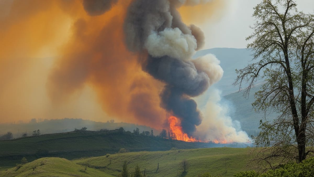
Image by Global Travel Alerts, Advisories, International Travel Alerts
Record-Breaking Heat and Wind Drive an Early Fire Season
Publicly available weather data for late March 2026 show temperatures running well above seasonal norms across the High Plains and southern Plains, with multiple sites breaking or approaching daily records. Forecast discussions from the National Weather Service highlight a persistent ridge of high pressure that is trapping heat and suppressing clouds, helping dry out rangeland and cropland weeks before the traditional peak of wildfire season.
At the same time, repeated strong wind events are sweeping the region. Surface observations and outlooks from the Storm Prediction Center describe gusts regularly topping 40 to 50 miles per hour across parts of Nebraska, Colorado, Oklahoma and Texas, particularly along the corridor from the Front Range into the central Plains. These winds are combining with relative humidity values in the teens and single digits to create what forecasters classify as critical or extremely critical fire weather conditions on numerous days in March.
Reports indicate that this pattern has primed grasslands and brush in counties such as Powell in Montana, Fremont and other Colorado counties, Garden and Morrill in Nebraska, and El Paso and other parts of Texas for rapid-fire spread. In many of these areas, vegetation that flourished after recent moisture has since cured, leaving a heavy load of fine fuels ready to ignite when exposed to downed power lines, roadside sparks or other ignition sources.
Climate monitoring summaries released this month note that much of the central United States entered spring with significant rainfall deficits, especially across western Nebraska, eastern Colorado and the Texas Panhandle. Those shortfalls, layered on longer-running drought classifications in parts of the region, have intensified concerns that March’s early wildfires are a harbinger of a prolonged and dangerous fire season.
Nebraska’s Morrill Fire Signals the Scale of the Threat
The most dramatic sign of the escalating risk has been in western Nebraska, where the Morrill Fire and related blazes have burned across an enormous swath of rangeland since igniting in mid-March. According to incident summaries and state situation reports, the Morrill Fire grew into the largest single wildfire in Nebraska’s recorded history, affecting Garden, Morrill, Keith, Arthur and neighboring counties and scorching more than 600,000 acres at its peak.
Satellite-based fire perimeter mapping and state briefings describe walls of flame driven eastward by severe winds, with grass and pastureland carrying fire at speeds that left limited time for defensive measures. Publicly available information from regional news outlets indicates that evacuations were ordered in several communities and that at least one fatality has been linked to the outbreak, underscoring the human toll of the event.
Garden and Morrill counties have been at the center of this crisis. Local coverage from the Nebraska Panhandle details how fast-moving vegetation fires jumped roads and firebreaks as wind gusts aligned with open terrain. Video and imagery shared by residents and emergency managers show blackened Sandhills pastures, destroyed fencing and damaged agricultural infrastructure stretching for miles.
Even as containment percentages have improved with cooler nights and targeted firelines, state agriculture and emergency agencies are preparing for a lengthy recovery. Initial assessments point to extensive losses of grazing land, challenges in relocating livestock, and the need for hay, fencing materials and financial support for affected producers in Morrill, Garden and surrounding counties.
Texas and Oklahoma Face Intensifying Grassfire Conditions
Farther south, much of Texas and western Oklahoma is entering what state fire agencies describe as the heart of the spring wildfire window. Climate outlooks for the Rio Grande Valley and Panhandle regions, released by the National Weather Service earlier this year, warned that cured grasses left behind by a winter cold blast could become highly flammable once temperatures rebounded and rainfall tapered off.
In response, fire weather alerts and red flag warnings have become frequent across counties such as El Paso and neighboring areas of far West Texas. Local meteorologists in cities like Lubbock have highlighted the combination of well above average temperatures, ongoing drought indicators, low humidity and intermittent strong winds as key ingredients for large grassfires. Public forecasts emphasize that even routine activities such as welding, outdoor burning or pulling trailers with dragging chains could ignite fires under these conditions.
Oklahoma has seen similar patterns. Regional outlooks and media reports describe an alignment of dormant or curing grasses, gusty south winds and expanding pockets of drought stretching from the Panhandle into western and central counties. Fire managers are urging residents to stay aware of daily fire danger ratings as the atmosphere grows hotter and drier heading into April, when severe weather season and lightning strikes can add another ignition source.
These southern Plains trends mirror the early-season outbreak farther north, suggesting that the corridor from the Nebraska Sandhills to the Texas-Mexico border may face repeated rounds of wildfire risk as the warm season advances, especially on days when dryline setups or passing storm systems intensify winds.
Colorado and the Central High Plains on High Alert
On the central High Plains, Colorado counties, including Fremont and others along the Front Range and eastern plains, are managing their own early season flare-ups. News coverage from the state in recent days has noted smoke plumes visible from communities near the foothills and grassfires racing across open land when downslope winds align with dry fuels.
Forecast offices serving Colorado, Kansas and adjacent states have repeatedly flagged critical fire weather days when humidity drops sharply during the afternoon and winds accelerate ahead of passing cold fronts. These setups have prompted fire weather watches and red flag warnings that often extend into counties across the border in Nebraska and Kansas, drawing attention to the shared risk that spans state lines.
Powell County, which sits along important transportation and ranching corridors, has recently been added to the roster of jurisdictions dealing with wildfire incidents tied to this broader pattern. Situation summaries indicate that local agencies there have been called on to tackle fast-moving grass and brush fires fanned by shifting winds, at times in difficult terrain that complicates direct attack.
The concentration of simultaneous wildfires and high fire danger days across the broader region is straining resources. Publicly available situation briefs from federal and state coordination centers show engines, aircraft and crews being shifted between incidents in Colorado, Nebraska and surrounding states as priorities change with weather and fire behavior.
Communities Brace for a Long, Uncertain Summer
Across Powell, Morrill, Garden, El Paso, Fremont and other affected counties, communities are beginning to reckon with the possibility that the March outbreaks are only the first phase of a long wildfire season. Seasonal outlooks for late spring and summer lean toward above-normal temperatures over much of the central and southern Plains, raising concerns that recent fires could be followed by additional waves of dangerous conditions as the year progresses.
Local governments and land managers are using the current window between major wind events to reassess fuel breaks, review evacuation plans and encourage residents to prepare defensible space around homes, barns and critical infrastructure. Public messaging from state forestry and emergency agencies stresses that human-caused ignitions remain the most controllable part of the wildfire equation, urging caution with any activities that could generate sparks or open flame.
At the same time, early damage assessments from Nebraska and neighboring states are beginning to quantify the economic impact. Ranchers and farmers face months or years of recovery as they rebuild fencing, reseed pastures and navigate disrupted grazing rotations. Insurance and disaster assistance programs are being examined for ways to address losses that occurred unusually early in the calendar year, before many producers expected severe fire impacts.
For residents across the corridor from Colorado through Nebraska, Oklahoma and Texas, the rapid onset of the 2026 fire season is altering expectations about when the landscape is most at risk. As heat records fall and strong, dry winds continue to sweep the Plains, early wildfires in Powell County and its counterparts may serve as a stark signal that traditional notions of “fire season” are shifting in a warming climate.