
More news on this day
New York City and much of the US East Coast are bracing on Sunday, February 22, 2026, for a rapidly intensifying bomb cyclone that forecasters warn could deliver blizzard conditions, crippling travel and some of the heaviest snowfall in nearly a decade along the Interstate 95 corridor.
Bomb Cyclone Threatens Northeast With Rare Intensity
Forecasters describe the unfolding storm as a classic late‑season nor’easter undergoing bombogenesis, a rapid drop in atmospheric pressure that intensifies wind and snowfall over a short period. Meteorologists expect the system, unofficially named Winter Storm Hernando, to deepen off the Mid‑Atlantic coast before tracking northeastward parallel to the shoreline Sunday night into Monday.
As the low pressure center intensifies offshore, it is forecast to sling bands of heavy, wind‑driven snow across major metropolitan areas from Washington to Boston. The New York City region sits near the projected bull’s‑eye of the storm, with the heaviest snow likely Sunday evening through Monday morning. Snowfall rates in the core band could exceed 2 inches per hour, a threshold that quickly overwhelms plows and renders treated roads treacherous.
Unlike lighter systems that clip the coast and move on, this storm is expected to slow and deepen as it reaches the waters south of Long Island and New England. That stall raises the risk of prolonged whiteout conditions, especially along exposed coastal communities and elevated roadways. The combination of deepening low pressure, a strong coastal jet and bitter Arctic air funneling in from the northwest sets the stage for a potentially historic event for late February.
Weather models show the storm’s central pressure dropping rapidly enough to qualify as a bomb cyclone, a term that has become more familiar to the public in recent winters. While the phrase can sound sensational, for residents its practical meaning is straightforward: stronger winds, heavier snow and a narrower window to complete last‑minute travel or preparation before conditions deteriorate.
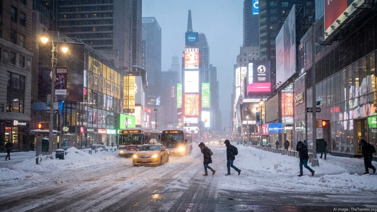
New York City Under First Blizzard Warning in Years
New York City awoke Sunday to its first blizzard warning in nearly a decade, covering all five boroughs from Sunday evening through Monday. The National Weather Service projects 12 to 20 inches of snow across the metro area, with localized totals above 20 inches possible where heavier bands linger. That would mark the city’s most significant single‑storm snowfall since early 2021 and comes on the heels of an already punishing winter across the region.
City officials moved swiftly over the weekend, declaring a state of emergency, imposing a full overnight travel ban for nonessential vehicles and announcing that public schools would be closed on Monday. The closures apply to in‑person classes, with some districts suspending remote instruction as well, citing concerns over widespread power outages and the need to keep families focused on safety and contingency planning.
Mayor Zohran Mamdani urged residents to complete essential errands by late afternoon Sunday and then remain indoors until the brunt of the storm passes. Sanitation and transportation crews have been on 12‑hour rotations since early Sunday, pretreating priority corridors including major bridges and tunnels, as well as bus routes and access roads to hospitals. Officials warned that even well‑equipped plow fleets would struggle to keep up once snow rates exceed 2 inches per hour in blizzard‑force gusts.
The New York metropolitan region is particularly vulnerable when severe winter weather aligns with peak travel periods, as it is poised to do in this case. With the heaviest snow expected overnight and into Monday’s usual commute, authorities are attempting to get ahead of the disruption by keeping office workers at home and reducing demand on subways, buses and commuter rails that may be forced to operate on reduced schedules or experience service suspensions on exposed segments.
Travel Chaos From Airports to Amtrak
Air and rail travel along the East Coast began unraveling even before the first flakes reached the major hubs. By midday Sunday, thousands of flights had been canceled at airports from Washington’s Reagan National and Dulles to New York’s LaGuardia and John F. Kennedy, Newark Liberty and Boston Logan. Airlines moved proactively to reposition aircraft and crew out of the storm’s path, warning passengers to expect multi‑day ripple effects across the national network.
For travelers already on the move, the approaching bomb cyclone has forced difficult choices. Many inbound flights to New York and Boston were diverted to Midwestern and Southern airports as conditions deteriorated ahead of schedule. Amtrak, citing expected whiteout conditions and heavy drifting on key segments, suspended or curtailed service on several Northeast Corridor routes, including high‑speed Acela trains between Washington, New York and Boston for parts of Sunday night and Monday.
Highway travel is likely to become equally fraught. State transportation agencies across New York, New Jersey, Pennsylvania and New England issued layered restrictions on truck traffic, banning tandem trailers and other high‑profile vehicles from major interstates where crosswinds and drifting snow are expected to be most severe. New York’s travel ban, set to begin at 9 p.m. Sunday for much of the five boroughs, is designed to keep highways clear for plows and emergency vehicles as the storm reaches peak intensity overnight.
Tourists already in the region for winter getaways or business often find themselves unexpectedly stranded during storms like this, with hotel lobbies filling as travelers search for last‑minute rooms near transit hubs. Hospitality operators at key nodes such as Times Square, Midtown Manhattan, downtown Brooklyn and Newark’s airport district reported a surge in booking inquiries over the weekend from travelers hoping to wait out the storm within walking distance of rescheduled departures.
East Coast Corridor Braces for Widespread Impact
Although New York City has drawn much of the attention, the storm’s footprint is far broader, covering a swath of the East Coast from the Mid‑Atlantic to New England. Blizzard warnings and winter storm warnings stretch from coastal Maryland and Delaware through New Jersey, eastern Pennsylvania, New York, Connecticut, Rhode Island and Massachusetts. Major urban centers including Philadelphia, Providence and Boston are all preparing for significant snowfall, high winds and coastal flooding.
In Philadelphia, forecasters predict what could be the city’s heaviest snow event in a decade, with 12 to 24 inches possible by Monday evening in the hardest‑hit neighborhoods. Local authorities there have urged residents to move vehicles off narrow residential streets so plows can operate more efficiently and to clear storm drains around their homes to reduce the risk of ponding as temperatures fluctuate later in the week.
Further north, Boston and much of eastern Massachusetts face the combined threat of deep snow, hurricane‑force gusts along the coastline and multiple rounds of coastal flooding at high tide. Emergency managers are especially concerned about barrier beach communities and low‑lying neighborhoods around Boston Harbor, where persistent easterly winds over several tide cycles can push water inland. Residents in vulnerable zones have been advised to relocate vehicles to higher ground and be prepared for short‑notice evacuation orders should storm surge projections worsen.
In Connecticut and Rhode Island, the storm has already strengthened into what local meteorologists describe as a bomb cyclone near peak intensity. Widespread snowfall totals of 10 to 20 inches are expected, with some locations potentially approaching 2 feet where banding sets up. Strong northeasterly winds are likely to cause scattered power outages and pile snow into deep drifts, especially in open coastal areas and higher elevations just inland.
States of Emergency and City‑by‑City Preparations
Governors in New York, New Jersey, Connecticut, Delaware, Rhode Island and Massachusetts all declared states of emergency ahead of the storm, unlocking additional funding and enabling more flexible deployment of personnel and equipment. Many states activated their National Guard units, positioning high‑clearance vehicles and search‑and‑rescue teams at strategic locations along the I‑95 corridor and in rural communities that can become isolated when drifts block local roads.
In New York City, the sanitation department has mobilized thousands of workers and hundreds of plows, salt spreaders and front‑end loaders. Crews began pretreating bridges, highway interchanges and known trouble spots days in advance and have placed heavy equipment at key corners in Manhattan and the outer boroughs to begin clearing intersections as soon as snow depth allows. Special attention is being paid to access routes for major hospitals, firehouses and police precincts.
Other cities across the region are following a similar playbook. Philadelphia, Newark and Jersey City have expanded their snow emergency routes, ticketing and towing cars left on key arteries after posted deadlines. Boston has announced parking bans on designated snow emergency routes and prepared its harborfront barriers in case elevated tides coincide with the strongest onshore winds. Transit agencies from Washington to Boston are urging riders to complete essential trips early, warning that bus routes on steep hills and exposed overpasses are particularly vulnerable to suspension.
For local governments still recovering from earlier winter storms in January and early February, this event represents both a logistical test and a financial strain. Snow removal budgets in several jurisdictions are already stretched after successive events, forcing officials to weigh overtime costs against the imperative to keep roadways and transit corridors usable for emergency response.
Power Outages, Coastal Flooding and Other Risks
Beyond hazardous travel, the bomb cyclone carries a suite of secondary risks that could significantly complicate life for residents and travelers. Foremost among them is the potential for widespread power outages, particularly in coastal and wooded suburbs where heavy, wet snow and gusts approaching hurricane strength can topple tree limbs and distribution lines. Utility companies across the region have called in mutual aid crews from less affected states, staging them just outside the highest‑risk zones to accelerate restoration efforts once conditions improve.
Coastal flooding is another major concern from New Jersey’s barrier islands to Cape Cod. Prolonged onshore winds pushing Atlantic waters toward the coastline, combined with already high astronomical tides, could inundate low‑lying roads, marinas and waterfront neighborhoods. In places where dunes and seawalls were weakened by earlier winter storms, emergency managers are watching closely for signs of erosion or overtopping that could force evacuations.
Urban infrastructure also faces strain from the expected snow load and ice accumulation. Officials in several cities have asked property owners to monitor flat roofs, awnings and older structures for signs of stress as the snow piles up. Public works departments are preparing to clear storm drains and catch basins once the snow begins to compact, aiming to reduce street flooding if temperatures rise above freezing later in the week.
Emergency shelters and warming centers are being opened or expanded from New York through New England, with particular attention to unhoused residents and those in inadequate housing. Social service agencies are coordinating wellness checks on seniors and people with disabilities, urging neighbors to look out for vulnerable residents who may lose heat or have difficulty accessing food and medication during the storm.
How the Storm Compares to Past Winter Sieges
The Blizzard of 2026 arrives in a winter already etched into the memory of many East Coast residents. A deadly and disruptive storm in late January brought significant snow and ice from Texas to Maine, followed by a powerful bomb cyclone in early February that battered parts of the Southeast and Atlantic Canada. For cities like New York, Philadelphia and Boston, the new storm threatens to stack fresh disruption on communities still digging out from earlier events.
Climatologists note that while blockbuster nor’easters are not new to the region, the clustering of high‑impact storms within a single season can magnify their social and economic toll. Businesses lose multiple workdays, municipal budgets strain under repeated cleanup costs, and transportation networks see compounding delays as crews rush to restore normal service between events. Residents who navigated previous storms with relative ease may find their personal resilience tested as supplies run low or fatigue sets in from repeated disruptions.
In terms of projected snowfall, the current system has the potential to rival several notable East Coast blizzards of the past few decades, particularly in pockets where banding persists. The difference this time, forecasters emphasize, is the storm’s rapid intensification offshore and its alignment with a deeply entrenched Arctic air mass, a combination that boosts the odds of sustained blizzard conditions over a densely populated corridor.
Scientists continue to study how a warming climate interacts with traditional nor’easter patterns. Warmer oceans can provide additional moisture and energy to developing coastal storms, while a disrupted jet stream may contribute to the blocking patterns that allow systems to linger. For now, however, emergency managers and residents alike are focused on more immediate questions: how much snow will fall, how long the winds will howl and how quickly essential services can recover.
Advice for Residents and Travelers Riding Out the Storm
As the bomb cyclone tightens its grip on the Northeast, forecasters and emergency officials are repeating familiar but vital guidance. Residents are being asked to remain off the roads once local travel restrictions take effect, both to reduce their own risk and to give plows and emergency vehicles room to operate. Those who must drive are urged to carry winter kits with blankets, water, snacks and phone chargers, and to let others know their routes and expected arrival times.
Within homes and hotels, authorities recommend preparing for the possibility of losing power, especially in coastal and wooded areas. That means charging devices while electricity is available, keeping flashlights and battery‑powered radios accessible, and avoiding the use of gas ovens or outdoor grills for indoor heating, which can lead to carbon monoxide poisoning. Residents with medical equipment that relies on electricity are urged to coordinate with local health providers or emergency services in advance.
For travelers whose flights or trains have been canceled, patience and flexibility will be essential. Airlines and rail operators are generally waiving change fees for customers affected by the storm, but seat availability may remain tight for days as carriers work through backlogs. Travel experts advise monitoring carrier alerts, rebooking through apps or websites when possible and avoiding unnecessary trips to airports or stations until itineraries are confirmed.
For all its disruption, the East Coast Blizzard of 2026 also serves as a stark reminder of the region’s vulnerability to fast‑changing weather systems. From city residents watching whiteout conditions from high‑rise windows to travelers unexpectedly extending their stays, millions of people are experiencing once again how a rapidly deepening coastal storm can reshape daily life along one of the world’s busiest travel corridors.