
El Yunque National Forest is one of the Caribbean’s most accessible tropical rainforests, and its trail network ranges from gentle riverside strolls to serious mud and elevation slogs that challenge even seasoned hikers. Ranking the best hikes by difficulty helps visitors match their ambitions and fitness levels to the terrain, especially in a place where heavy rain, slick rock, and dense vegetation can turn an otherwise simple walk into something far more demanding.
How Difficulty Works in El Yunque
Before choosing a route, it is important to understand what “easy,” “moderate,” and “challenging” really mean in this rainforest context. The U.S. Forest Service publishes official ratings for most trails, and local tourism boards and guide operators add nuance based on recent conditions. In El Yunque, an easy trail may still be muddy and uneven, a moderate trail may include steep stairways, and a challenging or very challenging hike usually combines significant elevation gain with slick, rooty ground and remote settings.
Conditions also change quickly. Trails that were damaged by hurricanes have been rebuilt, rerouted, or remain partially closed, while others have become more rugged as vegetation grows back and runoff reshapes the ground. The rankings below blend current official difficulty ratings with real‑world experience reports, grouping the best hikes from easiest to hardest so you can build an itinerary that progresses logically and safely.
Easiest Trails: Short, Scenic & Family Friendly
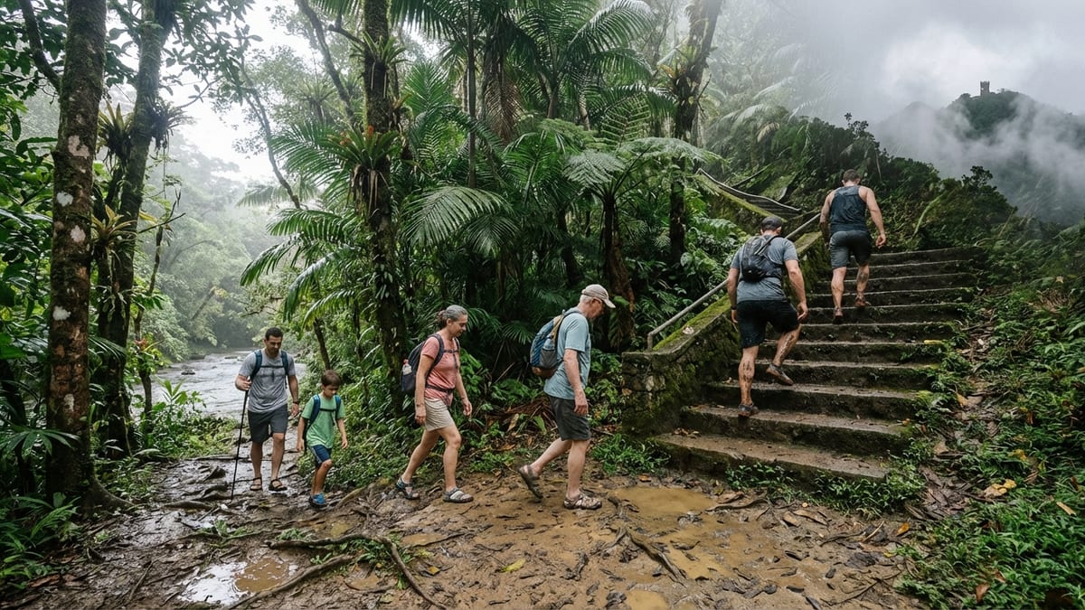
The easiest trails in El Yunque are ideal for families, casual walkers, or anyone adjusting to the rainforest’s humidity and slick surfaces. These routes stay mostly in the lower forest, follow gentle grades, and still deliver classic scenery such as clear rivers, swimming holes, and lush canyon walls.
Angelito Trail
Angelito Trail is widely considered the best introductory walk in El Yunque. The path descends gently through tabonuco forest to a wide bend in the Río Mameyes, where large boulders and clear pools invite visitors to swim and relax. The official distance is about 0.2 miles one way, and most people reach the riverside in 15 to 20 minutes.
The Forest Service and Puerto Rico’s tourism board classify Angelito as easy, but it still has an unpaved, sometimes muddy surface that can be slick after rain. That said, the short length, minimal elevation change, and broad track make it an excellent option for young children, multigenerational groups, or travelers who simply want a taste of the rainforest without committing to a half‑day hike.
Angelito is also less crowded than the upper‑elevation routes along Road 191. Expect more bird song than traffic noise and a different mix of vegetation than you will find higher in the cloud forest, with abundant ferns, gingers, and mossy rocks framing the river corridor.
Caimitillo Trail
Caimitillo is another short, easy loop in the upper part of El Yunque, starting near the Sierra Palm Visitor Center off Road 191. The route is about 0.4 miles and is designed as a nature walk, with a mostly smooth path that winds through dense palm stands and pockets of broadleaf forest.
Because it is higher and closer to the main scenic drive, Caimitillo feels markedly different from Angelito. Clouds are more common, the air is cooler, and you are likely to encounter interpretive signs, picnic structures, and spur connections to other trails. The Forest Service lists it as easy, and it is often recommended for visitors who want a short stroll paired with viewpoints and facilities.
Despite its easy rating, Caimitillo can be wet and slick, especially after passing showers. Good tread on your footwear and a willingness to step through standing water will help preserve the trail surface and keep the loop pleasant for everyone.
Baño de Oro & Other Micro Walks
Several extremely short walks, sometimes referred to as micro trails, branch off Road 191 and lead to historic structures, river overlooks, and old stone pools. One of the best known is Baño de Oro, an accessible path that showcases 1930s Civilian Conservation Corps stonework and a photogenic former swimming basin.
These routes are minimal in distance and elevation but provide important context about El Yunque’s human history, including early tourism development and conservation projects. They are ideal add‑ons to a day focused on viewpoints and waterfalls rather than long backcountry hikes, and they are particularly accommodating to those who need flat, even surfaces.
Moderate Trails: Stairs, Clouds & Classic Views
Moderate trails in El Yunque bridge the gap between casual walks and full workout hikes. Expect more sustained climbing, stretches of steep stairway, and higher elevation environments where mist, wind, and sudden showers are normal. These routes are where many travelers get their first real taste of El Yunque’s cloud forest and sweeping mountain vistas.
Mt. Britton Trail & Tower
Mount Britton is one of El Yunque’s signature climbs, a steep but relatively short path that leads to a stone tower perched at over 3,000 feet. The official trail length is about 0.8 miles one way, with a significant elevation gain that is compressed into a compact distance. The Forest Service labels it challenging, and local tourism authorities describe it as steep in places and often slippery, though still manageable for reasonably fit hikers.
The route begins along Road 191 and quickly enters dense stands of sierra palm before emerging in the stunted, moss‑laden vegetation of the cloud forest. On many days, the tower is fully surrounded by mist, giving the summit an otherworldly feel; on clear days, you can see out to the Atlantic and Caribbean, neighboring mountain ridges, and the coastal towns that ring the forest.
Because the trail is paved or hardened for much of its length, the main difficulty comes from the angle of ascent and the humidity rather than technical footing. Short switchbacks and steady stair sections demand leg strength, and frequent drizzle means you must be ready for wet surfaces even when the forecast looks fair at lower elevations.
Los Picachos Spur
Los Picachos is a short side trail that branches off the El Yunque Trail and climbs to a small stone platform with 360‑degree views. Although the spur itself is only about 0.2 miles, the Forest Service classifies it as moderate, in part because it is accessed via a considerable approach along El Yunque Trail and because the final ascent is up a steep, narrow stone staircase.
At the top, hikers stand within the elfin woodland, a rare ecological zone characterized by dwarfed trees, thick moss, and wind‑sculpted shrubs. On a clear day, the vantage point takes in the east coast of Puerto Rico, nearby ridgelines, and the mosaic of forest and development below. Clouds can sweep in quickly, so views may reveal themselves in brief, dramatic windows.
Los Picachos is often recommended as a stopping point for visitors who want a dramatic lookout without continuing to El Yunque Peak. The combination of short distance and steep steps makes it a perfect example of a moderate rainforest hike: physically demanding enough to raise your heart rate, but short enough to fit easily into a half‑day visit.
El Yunque Peak via Road 10 and El Yunque Trail
El Yunque Peak itself can be reached via a combination of Road 10 and the El Yunque Trail, with current access routing hikers around a section that has been closed for repairs. The main route now generally follows a paved or hardened path for much of its length, then transitions to more natural surfaces near the summit and side spurs.
Hiking guides and mapping services commonly rate this route as moderate to moderately challenging, with total distances of roughly 4 to 4.5 miles out and back and about 1,300 to 1,700 feet of elevation gain, depending on the exact starting point. The combination of continuous uphill walking, humidity, and high probability of rain or mist makes it more demanding than its numbers may suggest.
The payoff is significant. A small tower at or near the summit offers wide views on clear days, and even when clouds shroud the peak, the scenery along the way shifts from tall forest to elfin woodland, with orchids, bromeliads, and tree ferns framing the path. The trail is well traveled and clearly marked, which helps moderate hikers push a bit beyond their comfort zone without venturing into remote wilderness.
Challenging Trails: Longer Climbs & Tougher Footing
Challenging hikes in El Yunque introduce more distance, rougher footing, and sustained elevation change. These routes are best suited for hikers with good fitness, sturdy footwear, and comfort in wet, uneven terrain. They are legitimate workouts that can fill a morning or afternoon and may leave you caked in mud by the end.
El Yunque Trail (Traditional Route)
The traditional El Yunque Trail is a classic ascent to one of the forest’s high points, with trailheads near Road 191 and connections to spurs like Los Picachos. The Forest Service lists the trail distance at roughly 2.6 miles one way with more than 1,300 feet of elevation gain, classifying it as challenging. Portions of the historic route have been closed or rerouted while infrastructure repairs continue, so access currently involves combining open segments with road approaches.
Where it is open, the trail alternates between old asphalt, gravel, and native stone, with frequent muddy patches and water running down the path after storms. The grade is consistent and sometimes steep, and there are stretches where you will climb stone steps for extended periods. A rain shelter partway up offers a break from downpours, but most of the route is fully exposed to whatever the weather brings.
Hikers comfortable with steady climbing and slick conditions will find El Yunque Trail a rewarding intermediate‑to‑advanced option, especially when paired with the Los Picachos spur for even broader views. Those unaccustomed to heat and humidity should move slowly, hydrate often, and be prepared to turn around if thunderstorms build over the ridge.
La Mina Trail (When Open)
La Mina Trail has long been one of El Yunque’s most famous paths, descending from the upper forest down to a waterfall and pool that once drew large crowds. It is a compact route, roughly 0.7 miles one way, but its concrete staircases and sustained grade have earned it a challenging difficulty rating from outfitters and local operators. In the wake of hurricane damage, La Mina has at times been fully or partially closed while crews repair infrastructure and manage erosion.
When accessible, the trail typically requires 30 to 45 minutes each way, with most of the effort concentrated on the walk back out. Curving staircases, narrow landings, and consistently wet surfaces demand balance and leg strength, especially for those carrying packs or assisting children. Picnic shelters near the trailhead, many built by the Civilian Conservation Corps, offer rest stops and a glimpse into the forest’s Depression‑era development.
Because access status can shift with reconstruction work and weather, hikers interested in La Mina should verify current conditions with the Forest Service before planning around it. Those who do reach the falls should also be prepared for cool, powerful water and slippery rock around the pool’s edge.
El Toro Wilderness Trail (Lower Section Only)
The El Toro Wilderness Trail begins as a steep, often rutted path that quickly asserts its reputation as one of the forest’s most demanding routes. Many visitors, however, hike only the lower portion before turning back at a viewpoint or weather break, effectively transforming it into a challenging but not extreme out‑and‑back climb. Even over a shorter distance, the route’s slick mud, roots, and exposed rock require careful footing.
The lower section passes through tabonuco forest and then climbs into denser, more tangled vegetation as elevation increases. Fallen trees frequently lie across the path, especially after storms, forcing hikers to duck, scramble, or briefly detour. Drainage cuts channel water directly into the trail in many places, meaning that your shoes will almost certainly get wet and muddy even after a few dry days.
Hikers who enjoy athletic, hands‑on terrain and do not mind returning covered in mud will appreciate this route’s intensity, especially when clouds part to reveal the surrounding ridges. Those new to tropical hiking should see El Toro’s lower portion as an upper‑intermediate challenge rather than a casual stroll, and plan their turnaround time conservatively so that they are off the ridge well before afternoon thunderstorms.
Very Challenging & Expert Routes: For Serious Hikers Only
At the top of El Yunque’s difficulty spectrum are routes that combine steep grades, deep mud, remote settings, and route‑finding challenges. These trails are best attempted only by experienced hikers with strong fitness, proper footwear, extra water and food, and an understanding that rescue may be slow in poor conditions. Weather, trail damage, and closures can significantly affect their difficulty from month to month.
La Coca Trail
La Coca Trail begins near the well‑known roadside waterfall of the same name, but it quickly leaves the crowds behind as it drops into the lower montane forest. The path runs about 1.8 miles one way, with more than 650 feet of elevation change, and is officially rated very challenging. Local lodging providers and hiking guides emphasize that this is one of the steepest and muddiest routes in the park, and that it has been the setting for numerous search and rescue calls when hikers left the marked path.
The narrow track cuts across slopes, crosses small streams, and weaves through dense foliage that often obscures the sky. After heavy rain, sections can feel more like a watercourse than a trail, with knee‑deep mud and slick roots underfoot. The reward at the lower end is a meeting with the Río Mameyes, a federally designated Wild and Scenic River, where boulders and deep pools offer a rugged, untamed feel far from the paved overlooks uphill.
Because the trail’s main hazards involve footing and navigation rather than exposure or technical climbing, the line between an exhilarating adventure and a miserable slog is largely determined by preparation. Hikers should pack extra water, wear shoes with aggressive grip, follow trail markers religiously, and avoid La Coca during or immediately after major storms, when stream crossings can become hazardous.
El Toro Wilderness Trail to El Toro Peak
Continuing beyond the lower sections, the El Toro Wilderness Trail climbs all the way to El Toro Peak, at more than 3,500 feet the highest point in El Yunque and in eastern Puerto Rico. The full out‑and‑back distance is roughly 4.5 to 5 miles, with over 1,300 feet of elevation gain, but what makes this route truly expert‑level is not the numbers. It is the sustained combination of deep mud, washed‑out sections, encroaching vegetation, and downed trees that turn the hike into a slow, strenuous effort from the first mile onward.
Recent field reports consistently describe El Toro as one of the hardest hikes in Puerto Rico. Many hikers take well over four hours to complete the round trip, and it is common to arrive at the summit completely coated in mud. The path alternates between steep earthen steps, narrow ridgetop tracks, and short scrambles over roots and rock. In some places, landslides and erosion have cut into the trail, forcing careful route‑finding and balance.
The payoff is dramatic. On a clear day, the summit offers nearly 360‑degree views across the forest to both the Atlantic and Caribbean sides of the island. Even when clouds obscure the horizon, the ridge atmosphere, with wind, mist, and twisted vegetation, makes the effort feel like a true wilderness experience. Hikers attempting El Toro should carry more water than they think they need, plan for slow progress, and be prepared to turn around if thunderstorms, lightning, or heavy rain threaten the exposed upper slopes.
Tradewinds & Río Sabana Connections
On the south side of the forest, Tradewinds Trail connects with Río Sabana Trail and links remote areas of the El Toro Wilderness to Forest Road 191. The Forest Service lists Tradewinds as very challenging, with more than 4.5 miles of distance and substantial elevation change, and it notes that wilderness conditions and natural hazards are present along much of the route.
Overgrown segments, landslides, and washouts are common between El Toro Peak and the junctions with Tradewinds and Río Sabana, which means that experience with basic route finding is important even when the path is technically signed. Cell phone reception is limited or nonexistent for much of the way, so hikers must be self‑reliant, carrying paper maps, offline GPS data, and enough supplies to handle delays.
For strong, prepared hikers, the Tradewinds and Río Sabana network offers a sense of remoteness that is hard to find elsewhere in El Yunque, along with access to less visited river canyons and viewpoints. However, the commitment level is far higher than on front‑country trails along Road 191, and only those with backcountry experience and flexible schedules should attempt to combine these segments into long day hikes.
Planning Your Hike by Difficulty Level
Matching your route to your fitness and experience is crucial in El Yunque, where weather and trail conditions can change unexpectedly. A structured approach to planning helps you enjoy the forest’s beauty without overextending yourself or your group.
Choosing the Right Difficulty
Start by honestly assessing your comfort with heat, humidity, and uneven terrain. Visitors who are active at home but new to tropical hiking may find moderate rainforest trails more tiring than longer hikes in drier climates. If in doubt, choose an easier route for your first outing and build difficulty from there.
- For families with young children or older adults, focus on Angelito, Caimitillo, and very short roadside walks such as Baño de Oro.
- For reasonably fit travelers seeking views and a workout without full wilderness exposure, target Mount Britton, El Yunque Peak via Road 10 and the El Yunque Trail, and the Los Picachos spur.
- For experienced hikers wanting mud, solitude, and serious effort, plan on La Coca, the full El Toro Wilderness Trail, and, where open and safe, the longer combinations with Tradewinds and Río Sabana.
Moving up a level should always be deliberate. If a moderate trail feels at the top of your comfort zone, treat it as a capstone and save very challenging routes for a future trip when you can dedicate more time and preparation.
Gear and Safety by Difficulty Band
The higher you climb on the difficulty ladder, the more your gear and preparation matter. On easy trails, breathable clothing, grippy shoes or sandals, and a small daypack with water may be sufficient. As you shift into moderate and challenging territory, good hiking shoes with deep tread, trekking poles, and a lightweight rain shell become highly recommended.
- Easy: at least one liter of water per person, sun and insect protection, and shoes with real tread.
- Moderate: two liters of water, light snacks, rain protection, and a basic first‑aid kit; trekking poles are helpful for steep stair sections.
- Challenging and very challenging: two to three liters of water, substantial snacks or a packed lunch, full rain gear, headlamp, navigation tools, and backup power for phones. Expect to finish these routes muddy and potentially later than planned.
In all cases, check the Forest Service alerts for closures, flash‑flood warnings, and road status before setting out. Afternoon thunderstorms are common, and trails that feel benign in the morning can become hazardous after several hours of steady rain.
The Takeaway
El Yunque’s hiking network accommodates everyone from casual walkers to serious backcountry enthusiasts, but the rainforest’s unique mix of humidity, mud, and rapidly changing weather means difficulty labels carry different weight than they might elsewhere. Angelito and Caimitillo offer gentle introductions; Mount Britton, Los Picachos, and El Yunque Peak provide classic moderate climbs into the cloud forest; La Mina and the main El Yunque Trail challenge hikers with stairs and sustained elevation; and La Coca, El Toro, and the Tradewinds connections deliver true wilderness tests.
By understanding how difficulty works here and choosing your route with realistic expectations, you can experience some of the Caribbean’s finest rainforest scenery while staying safe and comfortable. Whether you are looking for a quick dip in a clear river or an all‑day climb to a windswept summit, El Yunque has a trail that will match your ambitions and reward your effort.
FAQ
Q1. What is the easiest hiking trail in El Yunque for first‑time visitors?
Angelito Trail is generally considered the easiest and most accessible option, with a short, gently graded path to a river pool that suits families, beginners, and travelers easing into the rainforest environment.
Q2. Which El Yunque hike offers the best views for moderate hikers?
Mount Britton Trail and its stone tower provide some of the most dramatic views for a moderate effort, and combining it with the El Yunque Peak route and the Los Picachos spur creates a full day of panoramic lookouts for reasonably fit hikers.
Q3. Are very challenging trails like La Coca and El Toro safe for solo hikers?
They can be, but they are not ideal for inexperienced solo hikers because of deep mud, steep sections, limited cell service, and the potential for rapid weather changes. If hiking alone, choose popular times of day, share your plans with someone, carry extra supplies, and be prepared to turn around early.
Q4. Do I need special equipment to hike in El Yunque’s more difficult trails?
For challenging and very challenging routes, sturdy hiking shoes with good grip, trekking poles, a waterproof jacket, and extra water and food are strongly recommended, along with a headlamp and basic first‑aid kit in case delays push you later into the afternoon.
Q5. How does rain affect trail difficulty in El Yunque?
Even light rain can make stone steps and earthen paths extremely slick, raise water levels in streams, and turn already muddy sections into deep ruts, effectively upgrading the difficulty of many trails by a full level compared with dry conditions.
Q6. Is it possible to hike El Yunque Peak and Mount Britton in the same day?
Yes, many visitors combine Mount Britton and El Yunque Peak into a single outing by linking the trails near the ridge, but the combined hike involves sustained elevation gain and should be approached as a solid half‑day effort with appropriate water, food, and weather awareness.
Q7. Are reservations or permits required for hiking in El Yunque?
Recent policy changes have removed the need for day‑use reservations in many areas, but road access, parking controls, and occasional pilot systems can change, so it is wise to check the latest Forest Service announcements before your visit.
Q8. Can children handle the moderate trails in El Yunque?
Active children often enjoy moderate routes like Mount Britton or the lower portion of the El Yunque Trail, but parents should factor in steep stairs, humidity, and slippery footing, choosing shorter objectives and allowing plenty of breaks.
Q9. What time of day is best for tackling the most difficult hikes?
Early morning starts are best for challenging and very challenging trails, as they provide cooler temperatures, more daylight margin in case of delays, and a better chance of avoiding afternoon thunderstorms that frequently develop over the mountains.
Q10. How should I decide whether a trail’s difficulty is appropriate for me?
Consider your usual activity level, past experience on muddy or steep trails, and how you handle heat and humidity, then choose a route one step below what you think you can manage; if that feels comfortable, you can always attempt a harder hike later in your trip.