
Until I met Lake Superior up close, the Great Lakes were an abstraction: blue shapes on a map, a background to weather reports and shipping forecasts. I knew they were vast and important, but my understanding stopped at the waterline. It was only when I walked Superior’s cobble beaches, paddled below its sandstone cliffs, and watched storms roll in across its cold horizon that I realized how incomplete that picture had been. Lake Superior, in particular, is not just another large lake. It is a place that rearranges your sense of scale, power and time, and by doing that it reshapes how you think about the entire Great Lakes system.
Meeting a Lake That Feels Like an Ocean
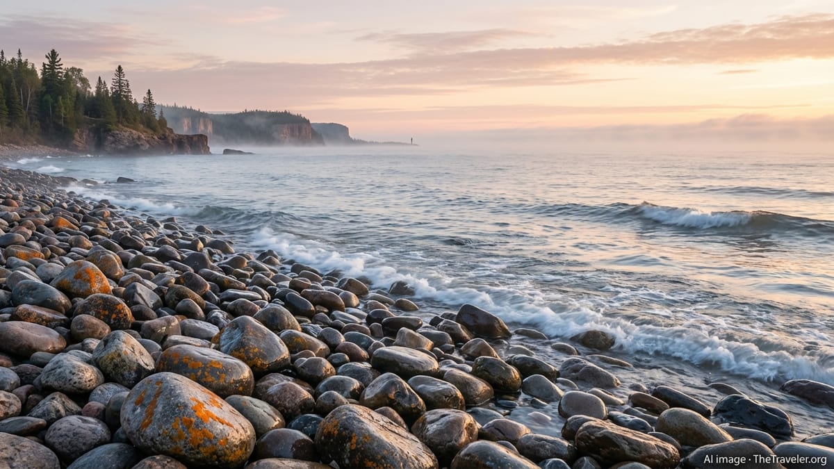
My first close encounter with Lake Superior came on a calm July evening near Bayfield, Wisconsin. The water looked almost soft, a sheet of brushed aluminum under a high, pale sky. From the shoreline it was difficult to see where the lake ended and the sky began. There were no far banks on the horizon to reassure the mind that this was just a lake. Superior occupied the entire field of vision, a horizontal infinity that felt more like standing at the edge of the Atlantic than at the shore of an inland water body.
That illusion of oceanic scale is not just visual. The air itself is cooler by several degrees, with a density and dampness that you feel in your lungs and on your skin. Weather moves differently here, flowing across more than 300 miles of uninterrupted water before it hits land. Even on summer days, you can feel the memory of ice clinging to the wind. These first impressions worked quietly but decisively on my assumptions, suggesting that the word “lake” might be too small for what lay in front of me.
Later that night, as the light drained from the sky, I walked back down to the shoreline. Small waves were breaking in a steady rhythm, pushing rounded stones up the beach and dragging them back with a soft clatter. There were no city lights on the opposite shore, only darkness and the red wink of a distant navigation beacon. In that half-light, with nothing but the sound of stones and water, Superior felt less like a destination and more like a presence. It was the first time I understood why so many people refer to it simply as “the lake,” as if no other could possibly compete.
Standing there, I realized I had always imagined the Great Lakes as interchangeable: a chain of similar basins with different names. The reality was more nuanced. Superior, with its size, depth and cold, sets the tone for everything downstream. Its water will eventually slide through locks and rivers to Lakes Huron, Erie and Ontario, but it begins here, in a place that behaves as much like an inland sea as a lake.
Seeing Depth and Time in the Apostle Islands
To feel Superior’s personality more fully, I headed out into the Apostle Islands National Lakeshore off the northern tip of Wisconsin. From the water, the islands rise in low, forested humps, their shorelines carved into sea caves and arches. Kayaks move easily along the base of 200-foot sandstone cliffs, slipping into honeycombed recesses where waves boom, echo and toss cool spray into the air. The national lakeshore protects 21 islands and miles of mainland shoreline, a mosaic of lighthouses, old-growth forest and wild beaches that make tangible the meeting point of geology, ecology and human history.
The first time I eased my kayak into a narrow cave, I was struck less by the play of light on wet sandstone than by the water below. It was incredibly clear, a cold, green lens that dropped into a darkness no paddle could touch. The Great Lakes always sounded deep on paper, but Superior forces you to confront that depth directly. Here, visibility can extend many meters down, and yet the bottom seems to fall away endlessly. You are floating on a volume of fresh water so vast that it holds most of the surface freshwater on the planet, and in that simple fact your own scale shrinks.
On shore, walking under white pines and hemlocks, the sense of depth shifted from vertical to temporal. The sandstone cliffs here were laid down hundreds of millions of years ago. Glaciers later gouged and scoured the bedrock to create the basin that now holds Superior. The islands themselves are remnants of that retreat, a record of ice and meltwater written in stone. Looking out from a lighthouse platform at the edge of one of these islands, the smooth spread of the lake suddenly felt like the thinnest of veneers over an older and rougher story. Time, here, runs both long and deep.
This layered sense of time changed how I thought about all the Great Lakes. They are not accidental puddles or oversized recreational reservoirs. They are the most recent expression of long geological processes, and they define entire regional climates and cultures. When you stand in the Apostles and watch Superior’s water marching off toward Michigan, Huron and beyond, you understand that these lakes are chapters in a single, continuing narrative.
Shipwreck Coasts and a New Respect for Risk
My appreciation of Superior’s power deepened along the shipwreck coast near Whitefish Point in Michigan’s Upper Peninsula. This stretch of southern shoreline has been called the graveyard of the Great Lakes, where storms, fog and heavy traffic have claimed hundreds of vessels over the past two centuries. Today, an underwater preserve protects many of those wrecks, and museums at Whitefish Point tell their stories. Standing on the beach with the wind cutting in from the northwest and waves piling up in long, muscular sets, it became easier to understand how a modern ore freighter like the Edmund Fitzgerald could vanish here in a single November night.
At first, the statistics about lost ships felt remote and historical. The lake that morning was a restless gray, but there were families with dogs on the beach and a handful of rock pickers sorting agates from rounded stones. It did not immediately read as an extreme environment. Then a squall line advanced across the water, darkening the sky and throwing a jagged edge of whitecaps ahead of it. In minutes the wind intensified, temperatures dropped, and the lake changed character entirely. Waves broke harder on the bar, and even on shore you had to lean against the gusts. The shift felt sudden but not unusual here, and that made it more unsettling.
The Great Lakes are often framed as safer or more benign than open oceans, but Superior undermines that assumption. Cold water and long fetches create steep, confused seas. Weather can deteriorate quickly, and in exposed areas there is no sheltered harbor close at hand. Speaking with locals and guides, you hear the same refrain: respect the lake. Even experienced mariners and paddlers approach Superior conservatively, checking marine forecasts repeatedly, planning for sudden weather changes, and carrying proper safety gear.
That respect has reshaped how I think about recreation and risk across all five lakes. The same forces that sculpt impressive cliffs and support thriving coastal communities also demand humility from visitors. Whether you are crossing Lake Michigan in a sailboat, fishing on Lake Erie or paddling along Lake Ontario’s shores, the lessons from Superior apply. Freshwater does not mean forgiving. These inland seas are working waters and dynamic systems, not simply scenic backdrops.
Kayaking Close to the Cliffs at Pictured Rocks
Nowhere did the intimacy of Superior feel more intense than along Pictured Rocks National Lakeshore in Michigan. This protected stretch of shoreline runs for more than 40 miles between Munising and Grand Marais, its cliffs stained in bands of copper, iron and manganese that drip and swirl into patterns worthy of an art gallery. From a kayak, the cliffs tower above in streaked shades of ocher, green and red, interrupted by waterfalls that pour directly into the lake.
Kayaking here is both exhilarating and sobering. Sea kayaks, rather than recreational boats, are strongly recommended for these conditions, and for good reason. The water is frigid even in midsummer, and the cliffs offer few easy landings. Swells rebound unpredictably from the rock, turning otherwise manageable waves into chaotic cross-chop. Local outfitters emphasize skills, equipment and emergency planning, stressing that good conditions can change within an hour. Listening to their briefing on shore, the lake in front of us looked almost lazy, but every story they told carried the same moral: underestimate Superior at your peril.
Out on the water, the briefing’s seriousness made sense. As we paddled beneath a natural arch known locally to tour operators and slipped under seeps that cooled the air, the lake felt alive in a more complex way than any reservoir or smaller inland lake I had known. There was an interplay between wave, rock and wind that never quite settled. At one moment we were gliding over emerald water so clear it looked like glass; the next we were climbing the back of a long swell that raised us to eye level with color bands high on the cliff.
Experiences like this altered how I thought about access and adventure on the Great Lakes as a whole. It is easy to imagine these waters as endlessly approachable: just another place to rent a kayak or a paddleboard. Yet Superior’s cliffs teach that some shorelines require more preparation and respect. It is a lesson that resonates on other exposed coasts, from the open beaches of Lake Michigan to the wilder stretches of Lake Huron’s North Channel. The Great Lakes offer some of the finest freshwater paddling on earth, but they are not built for casual complacency.
Hidden Communities and Cultures of the North Shore
For all its wildness, Lake Superior is also deeply human. Small towns and tight-knit communities dot its Minnesota, Wisconsin, Michigan and Ontario shorelines, each shaped by the lake’s moods and opportunities. Along Minnesota’s North Shore, places like Two Harbors, Silver Bay and Grand Marais grew up around logging, mining and shipping. Today, many lean heavily on tourism, but the working character remains. Ore carriers still pass Split Rock Lighthouse, and commercial boats share harbor space with charter fishing vessels and recreational sailboats.
Staying in these towns reveals another dimension of Superior and, by extension, the Great Lakes. Conversations over coffee drift naturally to weather, ice cover and water levels. People discuss late freeze-ups or unusually warm autumns with a level of attention more typical of farmers and their fields. The lake is not scenery; it is infrastructure, livelihood and identity. Many residents measure time in shipping seasons, storms survived and winters when the ice road held longer than expected.
This lived relationship with Superior extends to a strong culture of stewardship. Locals talk about invasive species, water quality and shoreline erosion with a sense of personal stake. Community groups organize beach cleanups, citizen science projects and advocacy efforts. In harbor-side bars you hear debates about how to balance access with protection, and how to welcome more visitors without overwhelming fragile shorelines and small-town resources. These conversations mirror similar discussions around the other Great Lakes, reminding visitors that they are stepping into an ongoing regional dialogue.
By spending time in these communities, my view of the Great Lakes shifted from abstract resource to shared neighborhood. It became clear that what happens on Superior’s shore affects fisheries in Lake Huron and water quality downstream in Lake Erie. The lakes are not isolated recreational zones or separate tourism clusters. They are a connected system that supports millions of people and countless nonhuman species, and the health of one influences the resilience of all.
Cold, Clarity and the Living Lake
One of the most striking impressions of Superior up close is its water itself. Even in midsummer, the nearshore temperatures can remain startlingly cold. Wade in past your knees and your legs begin to ache. Slip off a kayak for a swim and the shock takes your breath away. This persistent chill is a defining trait of Superior, whose depth and northern latitude keep temperatures low much of the year. It also contributes to the lake’s famed clarity, with underwater visibility that can extend many meters in some areas.
That clarity is seductive. It makes paddling over shallow reefs feel like flying, and it turns every submerged boulder or half-buried log into a small museum exhibit. In designated underwater preserves, you can look down from the surface and see the ghostly outlines of old wooden hulls resting quietly on the bottom. Wrecks that in other waters would be obscured by silt or biological growth appear here almost suspended in time. The experience leaves a strong impression that Superior, and by extension the Great Lakes, function as vast, fragile archives.
Yet the water’s transparency can also disguise vulnerability. In conversations with researchers and educators along the shore, you hear concerns about changing ice cover, warming trends, and the spread of invasive species that alter food webs and water chemistry. The surface may look as pristine as ever, but beneath it the lake is adjusting to new pressures. The same is true across the Great Lakes basin, where management agencies and local groups wrestle with nutrient runoff, habitat loss and climate impacts.
Recognizing Superior as a living, changing system redefined my sense of the entire Great Lakes. They are not static backdrops for lighthouses and sunset photographs. They are dynamic ecosystems in motion, influenced by decisions made in cities, farms and forests far from the shoreline. To experience Superior up close is to confront that dynamism directly and to understand that the clear water at your feet carries stories, responsibilities and consequences downstream.
The Takeaway
Before I traveled to Lake Superior, the Great Lakes were part of the mental wallpaper of North American geography: large, important and safely distant. Experiencing Superior up close dismantled that distance. The lake’s sheer size, its ice-etched geology, its shipwreck history and its fiercely attached communities combined to turn a set of statistics into a visceral reality. Superior taught me that the Great Lakes are less a collection of five separate features and more a single, intricate system with a distinct headwater personality.
The lessons are both humbling and hopeful. Humbling, because Superior makes it clear how small individual travelers are in the face of deep time, cold water and fast-moving weather. Hopeful, because everywhere along its shore you find people who care intensely about this place and its future. From guides and park rangers to café owners and lighthouse volunteers, there is a shared belief that the lakes are worth knowing, respecting and protecting.
Leaving Superior, I found that I looked differently at every other Great Lake I encountered. The horizon of Lake Michigan felt a little more mysterious. The working harbors of Lake Erie seemed more deeply tied to a vast upstream story. Even maps of the region felt alive, the shaded blue of each lake no longer a symbol but a reminder of depth, history and connection. Once you have stood at Superior’s edge and felt the weight of its water, it becomes almost impossible to think of the Great Lakes as anything less than inland seas whose well-being is inseparable from our own.
FAQ
Q1. Is it safe to kayak on Lake Superior for beginners?
Kayaking on Lake Superior can be safe for beginners when done with reputable guides, proper sea kayaks, life jackets and close attention to weather, but conditions can change quickly.
Q2. What is the best time of year to experience Lake Superior up close?
Late spring through early fall typically offers the most accessible conditions, with milder temperatures and more predictable weather, though cold water and storms remain possible.
Q3. How cold is the water in Lake Superior during summer?
Even in midsummer, nearshore surface temperatures often feel very cold, and deeper water can remain close to freezing, so protective clothing is strongly recommended.
Q4. Do I need special gear to explore sea caves and cliffs by kayak?
Yes. A proper sea kayak, spray skirt, cold-water clothing, safety gear and local knowledge are important, especially near exposed cliffs and caves where landings are limited.
Q5. Are Lake Superior’s shipwrecks visible without diving?
In some shallow, clear areas you can see outlines of shipwrecks from boats or kayaks, but full exploration usually requires diving or glass-bottom tour boats where available.
Q6. How does Lake Superior influence the other Great Lakes?
Superior sits at the top of the system, feeding water downstream through rivers and locks, helping shape levels, temperatures and ecological conditions in the lower lakes.
Q7. What makes Lake Superior different from the other Great Lakes?
Superior is the largest and generally deepest, with colder water, a stormier reputation, extensive wilderness shorelines and a powerful sense of scale that feels almost oceanic.
Q8. Can you swim safely in Lake Superior?
Swimming is possible at many beaches, but the water is very cold, conditions can shift rapidly, and swimmers should stay close to shore and heed local warnings.
Q9. How can travelers minimize their impact when visiting Lake Superior?
Visitors can stay on established trails, pack out all trash, respect wildlife, support local conservation efforts and follow local guidelines on fires, camping and boating.
Q10. Why did experiencing Lake Superior change how you think about the Great Lakes?
Experiencing Superior revealed the Great Lakes as interconnected inland seas shaped by deep time, powerful weather and human communities, far more complex than simple map features.