
More news on this day
A powerful, coast-to-heartland winter pattern is slamming the United States this week, unleashing dangerous flash flooding in California and whiteout blizzard conditions across parts of Minnesota, triggering life-threatening travel chaos on highways, in mountain passes, and at some of the nation’s busiest airports.
Atmospheric Turmoil From Pacific to Upper Midwest
A volatile clash of Pacific moisture and Arctic air is driving a sprawling storm system that is battering the western United States before surging into the northern Plains and Upper Midwest. Forecasters say the multi-day event is capable of producing rapid-onset flooding in low-lying urban areas of Southern California, along with heavy mountain snow and treacherous ice and snow accumulations farther east into Minnesota. The result is a broad corridor of hazardous travel conditions, with authorities urging motorists and airline passengers to prepare for major delays, closures, and last-minute cancellations.
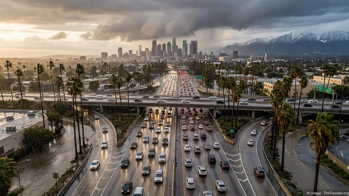
In California, a parade of moisture-laden disturbances is focusing heavy rain over saturated ground, particularly in and around the Los Angeles Basin and the coastal ranges. Even where day-to-day conditions fluctuate between bands of showers and brief breaks of sun, the cumulative rainfall on hillsides, burn scars, and concrete-lined channels is raising the threat of dangerous runoff and sudden street flooding. Emergency managers are watching smaller rivers, washes, and storm drains that respond quickly when intense downpours move through during peak commute hours.
Meanwhile, across Minnesota and neighboring states, a strengthening low-pressure system is drawing cold air southward, transforming a messy mix of rain, sleet, and freezing rain into periods of heavy, wind-driven snow. Gusty winds over open terrain are expected to reduce visibility, making highway travel hazardous even in areas that receive only moderate snowfall totals. Officials caution that the combination of snow, blowing snow, and rapidly dropping temperatures could turn wet pavement into a sheet of ice within hours, catching drivers off guard.
Los Angeles Braces for Flash Floods and Mudslide Peril
The Los Angeles metropolitan region, home to nearly 19 million residents and some of the nation’s busiest roadways and airports, is once again under the gun from another round of heavy rain. Multiple shortwave disturbances riding in on cool Pacific air are set to bring occasional downpours across the Southland, particularly from late this week into the weekend. While daily highs may hover in the more typical upper 50s and 60s Fahrenheit, forecasters stress that it is the intensity and timing of the rain bands, not the temperature, that carries the greatest danger.
Hydrologists and city engineers are closely monitoring areas that suffered burn damage in recent wildfire seasons, where water runs off faster and hillsides are more prone to debris flows. On steep canyon roads, a short period of heavy rain can dislodge rocks and mud, blocking lanes and stranding motorists. In densely built urban neighborhoods, overwhelmed storm drains can send water surging from curb to curb, quickly stalling vehicles caught in underpasses or low-lying intersections. Residents in flood-prone zones are being urged to move cars to higher ground and keep a close eye on official alerts.
Storm drains, concrete flood channels, and washes that wind through Los Angeles County are expected to run fast and deceptively deep, prompting repeated warnings for residents to stay away from watercourses. Even experienced hikers and photographers are at risk when sudden rises in water levels occur, particularly in narrow canyons and along creeks that may appear calm ahead of incoming cells. Authorities emphasize that rescues in swift water are extremely dangerous for both victims and first responders, and that avoiding flood channels altogether during heavy rain is the safest choice.
Highways, Freeways, and Passes: Travel Trouble in California
California’s already congested freeway system is likely to become significantly more treacherous as the storm cycle wears on. In and around Los Angeles, traffic reporters are preparing for a surge in spinouts, fender-benders, and multi-vehicle crashes whenever bands of heavy rain sweep over major arteries such as Interstates 5, 10, and 405. Oil and debris that have built up on the pavement during drier periods can create a slick surface at the onset of rainfall, reducing traction just as drivers are hurrying to work or home.
Farther inland and at higher elevations, including the Grapevine section of Interstate 5 through the Tejon Pass and routes leading into the San Bernardino and San Gabriel Mountains, motorists face a different kind of hazard. Here, colder air interacting with the storm moisture can bring low snow levels, icy patches, and sudden visibility drops in fog and heavy precipitation. Chain controls and temporary closures are possible if conditions deteriorate quickly, creating long backups and forcing truckers and vacationers alike to reroute or delay their journeys.
State transportation officials are advising drivers who must be on the road to slow down, allow extra following distance, and avoid sudden lane changes or hard braking. Travelers are urged to check real-time road reports before setting out, keep fuel tanks at least half full in case of delays, and carry basic emergency supplies such as blankets, water, and phone chargers. For those with flexibility, experts recommend shifting nonessential trips to drier periods between storm pulses or using public transit options where practical.
Blizzard Conditions and Whiteouts Threaten Minnesota Roads
As the storm system pivots into the Upper Midwest, Minnesota is facing the brunt of a classic late-winter onslaught: mixed precipitation transitioning to steady, wind-driven snow. Forecast models indicate that stretches of interstate including I-35, I-90, and I-94, along with numerous state highways and rural routes, could see rapidly worsening conditions as snow accumulates on top of slush and meltwater from earlier rain and freezing rain. Even modest snowfall totals can become dangerous when combined with strong winds and falling temperatures.
In open country, especially across southern and western Minnesota, blowing and drifting snow are expected to create localized whiteouts, where visibility can plunge to near zero in seconds. Transport officials warn that drivers may suddenly lose sight of lane markings, other vehicles, and even the edge of the roadway, leading to a heightened risk of multi-car pileups. Snowplow crews will be out in force, but their effectiveness can be limited when winds are strong enough to blow freshly cleared snow right back onto the pavement.
Rural communities and travelers along secondary roads are being urged to monitor local alerts closely and to avoid nonessential travel during the peak of the storm. If venturing out is unavoidable, authorities recommend packing a winter survival kit that includes warm clothing, food, water, a shovel, traction material such as sand or cat litter, and a fully charged mobile phone. Motorists are also reminded to slow down for plows, give them ample room to operate, and remain in their cleared tracks rather than attempting risky passes in low visibility.
Air Travel Delays Ripple Through Major Hubs
The storm’s reach from Southern California to the Upper Midwest is also disrupting air travel across several major hubs, compounding the misery for passengers attempting to connect through an already busy late-winter schedule. In the Los Angeles area, bursts of heavy rain and low cloud ceilings can trigger instrument-approach protocols, forcing extra spacing between arrivals and departures at airports such as Los Angeles International and Hollywood Burbank. Even if these restrictions are intermittent, they can cascade into a daylong pattern of delays and missed connections.
In Minnesota, freezing precipitation followed by snow raises the specter of deicing backlogs and intermittent runway closures at major airports including Minneapolis–Saint Paul International. Aircraft may require multiple rounds of deicing fluid in prolonged wintry conditions, further slowing departures. Travelers on tight itineraries, particularly those with connections through other winter-prone hubs, are being warned to expect schedule disruptions that could stretch well beyond the immediate storm window.
Airlines are responding with a mix of flexible rebooking policies and proactive cancellations, especially on routes most likely to be affected by low ceilings, crosswinds, or icy runways. Industry analysts say that while carriers have become more adept at storm planning, the geographical breadth of this system means even airports under relatively benign skies may still feel the impact of equipment and crews being out of position. Passengers are encouraged to monitor their flight status frequently, enroll in text or app alerts, and build in additional time for security and boarding.
Life-Threatening Risks for Stranded and Vulnerable Travelers
Beyond the delays and inconvenience, authorities emphasize that this storm sequence poses genuinely life-threatening risks, particularly for travelers who become stranded on flooded roads in Southern California or in snow-choked, subfreezing conditions across Minnesota. In the Los Angeles region, even a few inches of swiftly moving water can sweep vehicles off roadways or trap occupants with little warning, especially at night or in areas where culverts and streams swell quickly. Officials consistently repeat the message that drivers should never attempt to cross flooded roadways, regardless of vehicle size.
In Minnesota, cold and wind are the primary dangers. A stalled or stranded car in heavy snow can rapidly become encased in drifts, with exhaust pipes blocked and carbon monoxide becoming a silent threat if engines are left running for heat. Exposure to wind chills well below freezing can lead to hypothermia or frostbite in a matter of minutes for unprepared travelers who attempt to walk for help. Public safety agencies advise staying with the vehicle, running the engine sparingly for warmth, cracking a window, and keeping the tailpipe clear when it is safe to exit and do so.
Particular concern is focused on vulnerable populations such as the elderly, those with medical conditions requiring regular treatments, and people experiencing homelessness who may seek temporary shelter in vehicles or improvised encampments. Social service providers and outreach teams are working with local governments to expand warming centers in Minnesota and emergency shelters in both regions. Travelers are urged to check in on family members or friends who may be at heightened risk and to share their itineraries when setting out in unstable weather.
Communities Respond as Travelers Seek Safer Options
In both California and Minnesota, communities are mobilizing resources in an effort to blunt the most dangerous impacts of the storms and give travelers safer options. In Los Angeles, city crews are working extended shifts to clear storm drains, distribute sandbags to residents in flood-prone neighborhoods, and post warning signs in low-lying underpasses and along canyon roads. Some local attractions and outdoor recreation areas are adjusting hours or closing trails due to the heightened risk of rockfalls, mudslides, and slippery conditions.
Across Minnesota, highway patrols, county plow crews, and emergency managers are coordinating in real time to prioritize key corridors for snow removal and to respond quickly to stranded motorists. In many communities, schools and public offices are weighing delayed openings or temporary closures when conditions become too hazardous. Hospitality businesses near major interstates, including motels and truck stops, are preparing for a spike in last-minute bookings as travelers decide to wait out the worst of the weather rather than push through.
Travel experts say this kind of broad, multi-state storm highlights the importance of flexibility and contingency planning for anyone on the move. They recommend that road trippers map out alternate routes and identify potential overnight stops in advance, while air travelers should consider booking longer connection times during peak winter months. For many, the safest choice may ultimately be to postpone or reroute journeys until the parade of storms abates and road and runway crews have time to restore more normal conditions.