
More news on this day
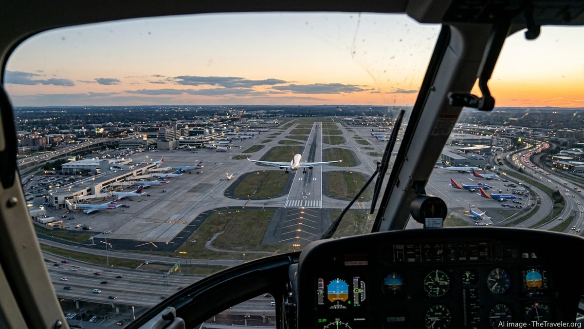
The Federal Aviation Administration is introducing a new radar-based separation requirement for helicopters operating near busy U.S. airports, replacing long-standing reliance on pilot "see and avoid" procedures intended to keep rotorcraft clear of commercial jet arrivals and departures.
Get the latest news straight to your inbox!
From Visual Separation to Radar Management
According to recent public notices and news coverage, the new policy directs air traffic controllers to use radar to maintain defined lateral or vertical spacing between helicopters and fixed-wing aircraft whenever rotorcraft cross or operate close to runway approach and departure paths in congested airspace. The change applies to more than 150 of the nation’s busiest airports, expanding an approach that was first implemented around Ronald Reagan Washington National Airport after a deadly midair collision in 2025.
Previously, controllers at many large airports were permitted to authorize helicopters to maintain their own separation from airliners using visual cues. Under that framework, a helicopter crew could report a nearby jet “in sight” and be cleared to pass beneath or near its flight path based on visual judgement. The updated rule removes that option in Class B and Class C airspace when helicopters transit the paths of arriving or departing jets, shifting responsibility for separation to radar-based control instead of pilot self-separation.
Operational documents describing the change indicate that controllers will now rely on established radar separation minima and techniques, including specified horizontal spacing measured on radar displays and the use of divergent headings, to ensure that jetliners and helicopters do not converge in confined terminal corridors. The intent is to standardize practices across the system and reduce variation in how mixed helicopter and fixed-wing traffic is managed around major airports.
The new requirement aligns with broader modernization efforts in the National Airspace System, where surveillance technologies and automation tools are increasingly used to supplement pilot situational awareness. Although the policy is framed around radar, it is expected to work in tandem with other surveillance sources such as transponder-based systems, depending on what is available in a given terminal area.
Safety Concerns After Midair Collision and Near Misses
The shift follows heightened scrutiny of helicopter operations around large airports after a 2025 midair collision near Washington, D.C., involving a regional jet and a military helicopter operating in the traffic pattern along the Potomac River. Investigative findings described in publicly available reports highlighted heavy reliance on visual separation, limitations in “see and avoid” techniques at night and in complex airspace, and questions about the design and oversight of helicopter routes that intersected with jet approach paths.
In the months after the crash, additional incidents and reported near misses at other U.S. airports added urgency to calls for structural changes. Coverage by national outlets has pointed to events in busy terminal areas such as New York, the Los Angeles Basin, and San Antonio, where passenger jets and helicopters routinely share constrained corridors over dense urban environments. In several cases, onboard collision-avoidance systems issued resolution advisories when helicopters maneuvered close to airliners being sequenced for landing.
Safety advocates and aviation analysts have long cautioned that visual separation practices can be strained in high-workload environments. At large airports, jet crews may be focused on instrument procedures, weather, and runway conditions, while helicopter pilots flying unique low-level routes must navigate complex instructions, terrain, and rapidly changing traffic. The new radar-based policy is presented as a way to reduce the margin for error in these overlapping operations.
Public information about the regulatory change indicates that it also reflects lessons drawn from data analysis tools that flag loss-of-separation events and traffic conflicts. By examining radar tracks and system alerts from multiple facilities, the FAA has been able to identify patterns where helicopters repeatedly pass close to airliner flight paths, prompting a national rather than airport-by-airport response.
How the New Radar-Based System Will Work
Under the revised procedures, helicopters crossing arrival or departure paths in Class B and Class C terminal airspace will be subject to defined radar separation standards comparable to those used between fixed-wing aircraft. While specific numeric values vary depending on radar coverage and local procedures, controllers will generally be required to maintain at least a minimum horizontal distance, a minimum vertical buffer, or both, whenever helicopters and airliners could conflict.
To meet those standards, controllers may assign helicopters headings that diverge from jet approach paths, keep rotorcraft at altitudes that ensure vertical spacing while jets pass overhead, or hold helicopters outside final approach corridors until gaps in traffic allow compliant separation. In some locations, existing helicopter routes may be shifted farther from runway centerlines or restructured to run parallel to, rather than across, arrival flows.
Terminal-area radar systems and associated automation tools already in place at major airports are expected to underpin the change. These systems track aircraft positions and groundspeeds in near real time, give controllers visual cues about spacing, and can issue alerts when tracks appear to be converging. The new rules effectively require that these capabilities, previously applied most consistently to fixed-wing instrument traffic, be extended more systematically to helicopters in sensitive parts of the pattern.
Reports indicate that the radar-based separation mandate does not eliminate all forms of pilot visual responsibility. Helicopter and airplane crews must still maintain vigilance for other traffic, particularly outside controlled airspace or in locations where radar coverage is limited. However, for the critical segments of flight where rotorcraft intersect jet arrival and departure paths at the nation’s largest airports, separation will now be managed as an air traffic control function rather than an ad hoc visual arrangement.
Implications for Helicopter Routes, Delays, and Urban Mobility
The new system is expected to trigger adjustments to long-established helicopter procedures at major metropolitan airports, where rotorcraft have historically followed specialized routes across rivers, highways, and urban landmarks to minimize conflicts with airliners. Publicly available planning documents already describe modifications near Washington, D.C., where helicopter corridors along the Potomac have been pushed farther from jet approach paths and altitudes have been re-evaluated.
Aviation industry commentary suggests that some helicopter operators may face longer routings, altitude restrictions, or additional holding as controllers work to preserve radar separation buffers. For passengers and charter clients, that could translate into modestly longer flight times or occasional delays during peak arrival and departure banks at hub airports. At the same time, proponents of the change argue that greater predictability in how helicopters are handled could ultimately simplify planning and scheduling.
The policy arrives as cities and airports prepare for growth in advanced air mobility concepts, including electric vertical takeoff and landing aircraft designed for short urban and regional hops. Planning documents for the National Airspace System emphasize that higher volumes of rotorcraft and powered-lift traffic will require more structured integration with existing airline flows, not less. The radar-based separation framework is seen as one building block for an environment in which a wider array of aircraft types share the same constrained airspace around major hubs.
Airport communities and local governments may also see indirect impacts. Noise abatement procedures, preferred helicopter corridors, and community outreach efforts have often been built around routes that skirt final approach paths to runways. As those routes are adjusted for radar-managed separation, stakeholders may revisit how low-altitude tracks interact with neighborhoods, waterfronts, and landmark areas that are central to tourism and business travel.
Next Steps for Implementation Across the National Airspace System
Implementation of the radar-based separation requirement is expected to roll out in phases, beginning with the busiest Class B airports and expanding to other qualifying facilities as training and local procedures are updated. Air traffic control manuals and facility directives are being revised to reflect the end of visual separation for helicopters in affected scenarios, and controllers are receiving updated guidance on radar techniques tailored to mixed helicopter and fixed-wing operations.
Helicopter operators, airlines, and pilot organizations are reviewing the changes to assess operational impacts and identify any unintended consequences. Industry briefings and safety seminars are anticipated as stakeholders adjust to new expectations about how helicopters will be sequenced through terminal areas, particularly at airports where rotorcraft activity supports medical transport, law enforcement, offshore energy, or tourism.
According to publicly available FAA planning documents, the radar-based approach to helicopter separation dovetails with longer-term initiatives that use surveillance data, predictive tools, and time-based flow management to balance safety and efficiency. As these systems mature, analysts expect that mixed helicopter and jet operations in dense terminal areas will increasingly be managed through integrated traffic flow concepts rather than one-off visual arrangements.
For travelers, most of the changes will remain invisible, unfolding on controller radar scopes and in revised flight paths flown at low altitude around runway complexes. However, the policy represents a notable shift in how the U.S. aviation system handles one of its most challenging traffic mixes, with the aim of preventing rare but catastrophic collisions in some of the country’s most heavily traveled airspaces.