
More news on this day
Fiji is preparing for another spell of intense rainfall and rapidly rising waterways, as fresh government weather advisories warn communities nationwide of escalating flood risks in the days ahead.
Get the latest news straight to your inbox!
New Advisories Highlight Intensifying Wet Season Threat
Updated outlooks from the Fiji Meteorological Service indicate that March rainfall is expected to be normal or above normal across much of the country, reinforcing concerns that saturated catchments are increasingly vulnerable to renewed flooding. Climate guidance for March through May points to a high likelihood of several hundred millimetres of rain over western Viti Levu and parts of Vanua Levu, with some sugar belt districts forecast to receive in excess of 500 millimetres during the period. Recent climate updates also note that the 2025 to 2026 wet season has been shaped by a La Niña pattern that has favoured frequent heavy downpours.
The latest government weather advisories emphasize that tropical disturbances and converging rain bands can trigger prolonged torrential showers even when no named cyclone is present. These systems are capable of producing intense bursts of rain that overwhelm drainage networks, trigger flash flooding and fuel landslides on steep terrain. Publicly available information highlights that the official tropical cyclone season runs until the end of April, and that Fiji can still experience severe rainfall events during its closing weeks.
Meteorological guidance stresses that communities should treat heavy rain alerts with the same seriousness as storm warnings, particularly where rivers drain steep interior hills to densely populated coastal plains. The combination of saturated soils, king tides and onshore winds can intensify flood impacts along low lying shorelines and estuaries.
Western Viti Levu and Ba Corridor Under Close Watch
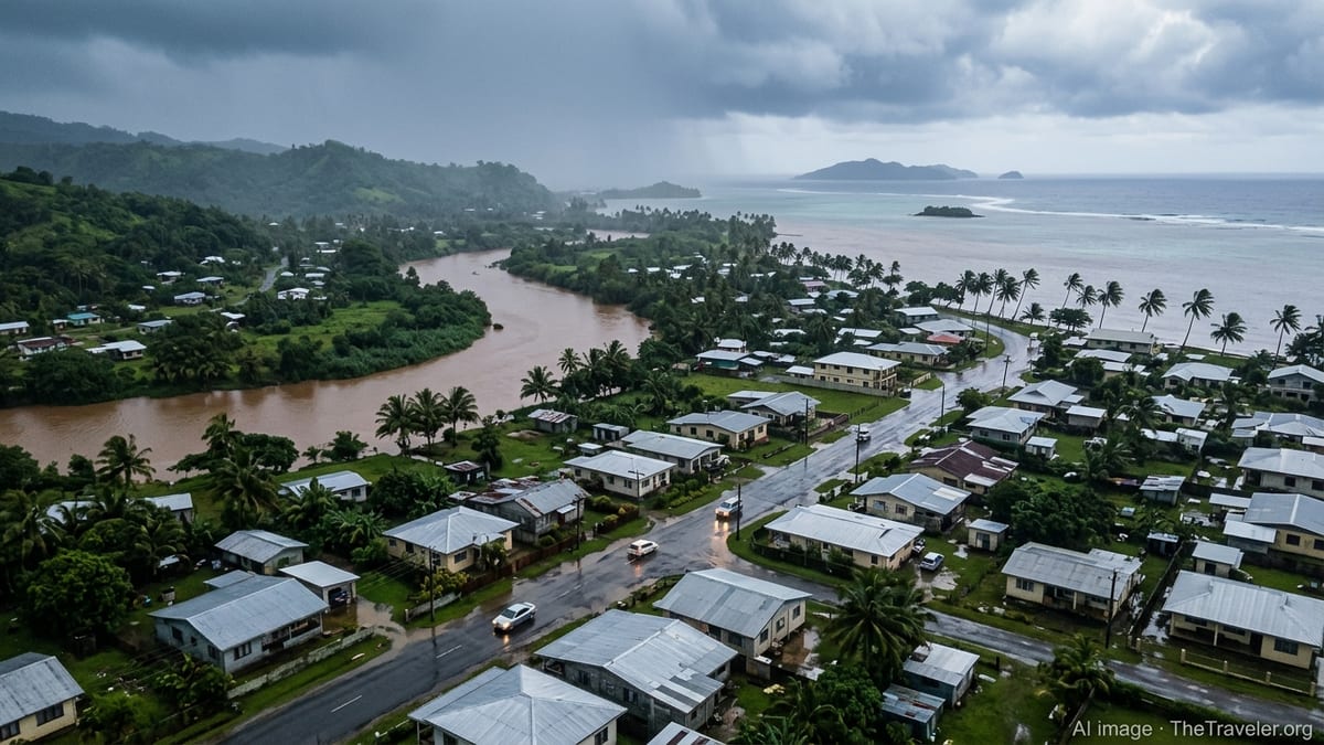
Western Viti Levu, including the Nadi Lautoka corridor and the Ba and Sigatoka river basins, remains a focal point of current concern. Seasonal outlooks published for the sugar cane regions project a strong chance of 200 to 300 millimetres of rain in many localities during March, with higher totals possible in selected interior catchments. These areas have already seen episodes of intense rainfall since late February, with local media coverage earlier in the month describing floodwaters entering Ba Town and disrupting business activity and road access.
Communities along the Ba, Tavua and Sigatoka rivers are being reminded through public advisories that river levels can rise quickly when heavy rain persists over the interior ranges. The flood risk is heightened by the presence of low lying town centres, road crossings and agricultural land close to riverbanks. In previous events this season, several hours of sustained rain have been enough to inundate shops, car parks and residential streets, underlining how narrow the margin can be between routine wet season showers and damaging floods.
Travelers using the Queens Road and Kings Road corridors are being advised by local reports to monitor official advisories closely, as sections prone to flooding and debris can become impassable with little notice. Public information also points out that secondary rural roads and low level crossings are especially vulnerable when river catchments are already saturated.
Recent Flooding Underscores Ongoing Vulnerability
The latest alerts arrive on the heels of several weeks of unsettled weather across Fiji. Monitoring reports compiled in late February and early March described episodes of heavy rainfall that led to flooding in parts of Viti Levu, including Ba, Sigatoka and other western localities. In some towns, rapid rises in floodwaters forced early closure of shops and offices as staff and customers were moved out of low lying premises.
Regional natural hazard summaries have highlighted Fiji as one of several countries that have already experienced damaging floods in early 2026. These overviews describe a pattern of intense, localized downpours capable of delivering more than a month’s worth of rain in a very short period, overwhelming urban drainage and rural river systems alike. The recurrence of such events across the region is being framed in public discussions as a reminder of the importance of early warning systems and local preparedness.
Within Fiji, past climate summaries from the national meteorological service show that March is often among the wetter months of the year, and that individual years can see exceptionally high rainfall totals. These records underline that even when no major cyclone strikes, a combination of active monsoon troughs and embedded tropical disturbances can bring hazardous conditions to both major islands and remote communities.
Government Guidance for Communities and Travelers
Current weather advisories are encouraging residents, businesses and visitors to pay close attention to official heavy rain and flood alerts and to plan activities with flexibility. Public guidance frequently recommends that communities in low lying or flood prone zones review evacuation routes, identify higher ground nearby and avoid sheltering in structures that have previously been affected by rapid flooding or landslides.
Travel focused information advises visitors to monitor local radio, television updates and government information channels for the latest forecasts and warnings. Travelers heading to resort areas around Nadi, Denarau, the Coral Coast and the Mamanuca gateways are being reminded that heavy rainfall can temporarily disrupt road transfers, domestic flights and ferry schedules, even when conditions at coastal properties remain relatively calm. Travel planners suggest allowing extra time for connections, carrying essential medications and keeping electronic copies of travel documents in case of unexpected delays.
Community level messaging across the country is also emphasizing basic safety steps such as avoiding flooded crossings, keeping children away from swollen drains and rivers, and preparing simple emergency kits that include drinking water, dry food, torches and essential personal items. Local coverage notes that even shallow floodwaters can conceal strong currents, open drains or debris, and that vehicles are at particular risk when attempting to cross submerged sections of road.
Climate Signals and the Outlook for the Coming Weeks
Seasonal climate products indicate that the Pacific is transitioning from a short lived La Niña episode toward more neutral conditions, yet the lingering influence of warm ocean waters and an active cyclone basin continues to favour above average rainfall for parts of Fiji. Recent documentation from the national climate service highlights a 75 percent chance of elevated rainfall totals across key agricultural districts through to May, suggesting that flood risk will remain elevated even outside of any single major storm.
Climate specialists contributing to regional assessments point to a broader pattern in which warmer seas and a more humid atmosphere have the potential to intensify extreme rain events. For island nations such as Fiji, this can translate into shorter, sharper bursts of rain that are more likely to produce flash flooding and infrastructure stress, particularly in fast growing urban and peri urban zones.
For now, the focus across Fiji is on navigating the closing weeks of the cyclone and wet season as safely as possible. With fresh government advisories highlighting the potential for further torrential showers and rapidly rising rivers, communities are being urged through public messaging to stay alert, take each new warning seriously and prioritize safety as weather systems continue to track across the archipelago.