
A powerful Atlantic weather system is sweeping into the United Kingdom, with forecasters warning that South and Mid Wales face hours of intense rainfall, heightened flood risk and mounting disruption to road, rail and air travel.
The latest Met Office guidance for Monday 26 January and Tuesday 27 January highlights a broad yellow weather warning for rain that includes much of Wales alongside parts of southwest England, the West Midlands and southern England, prompting emergency planners and travel operators to issue urgent advice to residents and visitors.
More News
- Edinburgh and Glasgow Overtake London as UK Nightlife Capitals, Airlines Boost Scottish Routes
- Canada Tightens Travel Warnings as Extreme Weather Claims 83 Lives
- Snowstorm Chaos in Manali: Tourists Stranded as Himachal Issues Urgent Travel Alert
Heavy Rainfall Targets South and Mid Wales
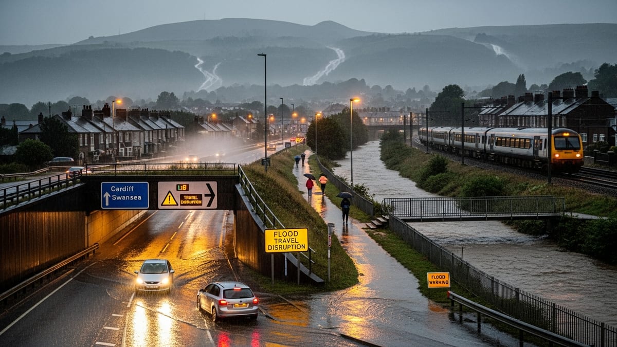
The Met Office warning, in force from Monday afternoon through to late morning on Tuesday, covers a swathe of southern and mid Wales including Cardiff, Swansea, Newport, Carmarthenshire, Ceredigion, Powys and the former mining valleys of Rhondda Cynon Taf and Merthyr Tydfil. Meteorologists expect prolonged outbreaks of rain, turning heavy and persistent at times, as a deep area of low pressure tracks across the south of the UK.
Forecast models suggest rainfall totals of 20 to 30 millimetres are likely widely across the warning area, with between 50 and 80 millimetres possible over higher ground such as Bannau Brycheiniog, formerly the Brecon Beacons. In these upland catchments, the combination of intense downpours, steep slopes and already saturated soils is expected to generate rapid surface runoff and potentially fast-responding river rises.
The warning comes after a sequence of unsettled days has left ground conditions across Wales and western England heavily waterlogged. With little capacity left in the soil to absorb further moisture, even moderate additional rainfall could quickly translate into standing water on roads, overtopping of smaller watercourses and fresh pressure on flood defences protecting low lying communities and critical infrastructure.
Flood Alerts Multiply as Rivers Respond Quickly
The Environment Agency and Natural Resources Wales have both signalled an elevated risk of river and surface water flooding as the rain band pushes inland. Dozens of flood alerts and more serious flood warnings are already in force across western catchments, including the Severn, Wye and Usk systems, with officials warning that numbers are likely to rise through Monday night into Tuesday as upstream rainfall works its way downstream.
Flood duty officers say particular attention is being paid to smaller, rapidly responding rivers and urban streams that run through built up areas in South Wales. These channels can react very quickly to intense rainfall, sometimes rising from normal levels to full bank within a few hours, leaving little time for residents and businesses to protect property or move vehicles to higher ground.
Surface water flooding is also a key concern, especially in towns and cities where large areas of tarmac and concrete prevent water from soaking away naturally. Blocked or overwhelmed drains and gullies can lead to sudden accumulations of water at underpasses, low spots on major routes and around rail lines, potentially cutting off access routes and stranding vehicles. Authorities are urging people never to attempt to drive through flood water and to be aware that just a small depth of fast flowing water can be enough to float a car.
Road, Rail and Air Travellers Warned of Disruption
Transport operators across Wales and western England are preparing for a difficult 24 to 36 hours as the heaviest rain coincides with busy commuting and school travel periods. The yellow warning explicitly notes the likelihood of spray and standing water leading to longer journey times, with some road closures possible where flooding becomes severe or where debris is washed onto carriageways.
On the rail network, infrastructure managers have introduced precautionary speed restrictions on exposed sections of line and in locations known to be vulnerable to landslips or flooding. Routes linking South Wales with the West Midlands and southwest England are expected to be among those at greatest risk of disruption, and passengers are being advised to check for live service updates before travelling and to allow additional time for their journeys.
Coach and long distance bus operators are issuing similar cautions to customers, warning that diversions around flooded stretches of road could add significant extra time to planned schedules. Some local bus routes in rural parts of Mid Wales may be curtailed or suspended if minor roads become impassable or if river crossings are deemed unsafe.
Airports serving the affected region, including Cardiff and Bristol, are monitoring conditions closely. While heavy rain alone does not usually force widespread cancellations, associated low cloud, strong crosswinds and restrictions on ground movements can lead to knock on delays. Passengers transiting through the region have been urged to keep in close contact with airlines and to build in contingency time when planning flight connections.
Impact on Communities, Tourism and Local Businesses
For many communities across South and Mid Wales, the latest warning arrives during what is already a challenging winter period marked by repeated spells of heavy rain, strong winds and occasional snow. Local authorities report that drainage crews and emergency response teams are working extended shifts to clear leaves and debris from culverts, inspect known pinch points and stand ready to respond to emerging incidents through the night.
In tourism dependent areas, including the coastal resorts of the Gower Peninsula and Pembrokeshire as well as popular walking centres in the Brecon Beacons, accommodation providers are fielding calls from visitors concerned about road conditions and potential access issues. Some operators report short notice cancellations from domestic travellers reluctant to risk long drives in challenging weather, even as international visitors continue to arrive on pre booked itineraries.
Outdoor activities such as hiking, trail running and adventure sports are likely to be heavily curtailed until conditions improve. Mountain rescue volunteers in Wales have asked visitors to postpone non essential upland trips, pointing to the heightened risk of swollen streams, slippery paths, rockfall and sudden changes in visibility. Coastal path walkers are also being urged to exercise caution near cliffs and to be aware of the potential for large waves and overtopping on exposed stretches of shoreline.
Tourists Urged to Rethink Itineraries and Prioritise Safety
Travel and tourism organisations are responding to the developing situation by steering visitors toward flexible planning and lower risk activities while the warning remains in force. Visitors are being advised to review day trip plans and consider shifting indoor activities, such as museum visits, cultural attractions and food experiences, to the peak hours of the storm, reserving outdoor excursions for periods when rain briefly eases and conditions are confirmed to be safe.
Those with driving holidays planned through affected parts of Wales and western England are being encouraged to keep routes as simple as possible, to avoid narrow country lanes prone to flooding and to stick where feasible to main roads that benefit from higher standards of drainage and more regular inspection. Car hire companies are reminding customers to familiarise themselves with vehicle controls for headlights, fog lights and ventilation to ensure clear visibility during heavy downpours.
Visitor information centres in key hubs such as Cardiff, Swansea, Brecon and Tenby are preparing updated weather and travel briefings in multiple languages, recognising that foreign tourists may be less familiar with the United Kingdom’s weather warning system and flood response arrangements. Staff are also signposting guests to local accommodation options if onward travel proves impossible and an unplanned overnight stay becomes necessary.
Public Agencies Issue Coordinated Safety Advice
In addition to the Met Office warnings, emergency planners across Wales and England have activated multi agency coordination groups bringing together police, fire and rescue services, ambulance trusts, local councils and utility companies. These forums allow real time sharing of information on flooding hotspots, vulnerable residents, road closures and power supply issues, helping responders to prioritise resources and keep the public informed.
Authorities are emphasising a series of simple preparedness steps for households and businesses in areas at risk. Residents are being asked to move valuables and important documents upstairs or to higher shelves where possible, to check that mobile phones and power banks are fully charged, and to ensure that they have access to basic emergency supplies including torches, batteries and any necessary medication in case travel becomes difficult.
Business owners in town and city centres subject to repeated surface water flooding have been advised to review flood protection measures such as installing door barriers, moving stock off ground level floors and confirming evacuation routes for staff and customers. Those with underground car parks or storage spaces have been warned to consider closing these areas temporarily if heavy rain coincides with high river levels.
Outlook for the Rest of the Week
While the current focus is on the most intense rainfall between Monday afternoon and Tuesday morning, forecasters caution that conditions are likely to remain unsettled for several days. Once the main rain band clears East Wales and central England, it is expected to fragment into heavy showers, some of which could still bring localised downpours, hail and gusty winds.
Another weather system is already lining up in the Atlantic, and there is potential for further spells of wind and rain to affect parts of the UK later in the week. Although forecast confidence decreases the further ahead models look, early indications point to a continuation of the pattern of frequent frontal systems crossing the country, maintaining a heightened risk of additional flooding where catchments have not had time to drain.
For travellers, the message from forecasters and transport operators alike is to keep monitoring conditions right up to the point of departure, as warning areas, validity times and local impacts may evolve on relatively short notice. With ground conditions so saturated and river levels elevated, even modest adjustments to the track or intensity of incoming systems could have significant implications for specific towns, transport corridors and rural communities.
What Travellers Need to Know Right Now
For anyone currently in or heading to South and Mid Wales, the immediate priority is to stay informed and stay flexible. Checking Met Office warnings, local authority updates and transport operator advisories several times a day will help travellers adapt plans as the situation unfolds. Officials stress that yellow warnings do not mean conditions will be severe everywhere, but they do signal a broad potential for disruption that can affect journeys at relatively short notice.
Visitors who are able to adjust departure times, reroute via less affected regions or extend stays by a day or two may find they can avoid the worst of the impacts. Those travelling on fixed itineraries, such as cruise connections, group tours or pre scheduled events, are being encouraged to build in generous buffers between connecting legs and to discuss contingency options with tour operators and insurers in advance.
Across the affected areas, authorities are asking both residents and visitors to plan journeys carefully, avoid unnecessary trips where conditions deteriorate, and never underestimate the power of fast flowing or standing flood water. In a winter that has already tested communities and infrastructure, this latest bout of heavy rain serves as another reminder that flexibility, preparation and respect for the elements remain essential parts of travelling around the United Kingdom at this time of year.