
More news on this day
Flash flooding in western Pakistan has blocked the Zhob–Dera Ismail Khan highway, leaving passenger coaches and freight traffic stranded on a key route linking Balochistan and Khyber Pakhtunkhwa, according to regional media reports and public updates from disaster agencies.
Get the latest news straight to your inbox!
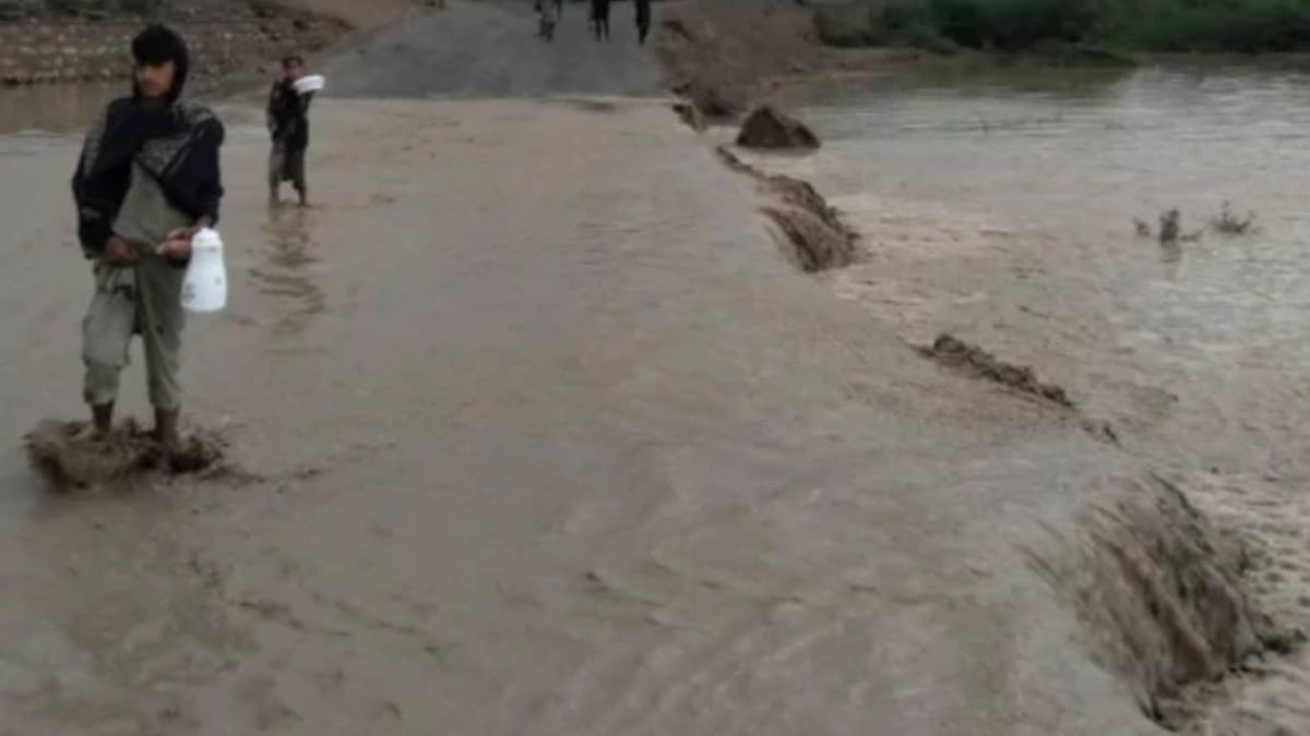
Image by The Express Tribune
Heavy Rains Trigger Sudden Highway Inundation
Recent rounds of intense rainfall over parts of northern Balochistan and southern Khyber Pakhtunkhwa have swollen seasonal rivers and storm channels, sending fast-moving floodwaters across sections of the Zhob–Dera Ismail Khan corridor. Publicly available information from weather and disaster agencies indicates that unstable spring weather systems have produced repeated downpours, heightening the risk of flash floods in already vulnerable districts.
Initial coverage from regional news outlets describes water coursing over low-lying stretches of the national highway alignment near Zhob and adjoining areas, making it unsafe for light vehicles and effectively cutting the road for long-haul buses and freight trucks. Images shared on local platforms show partially submerged carriageways and vehicles halted in long queues on higher ground while drivers wait for waters to recede.
The Zhob–Dera Ismail Khan route, part of the N-50 highway system, passes through rugged terrain dotted with narrow bridges and culverts that can quickly become choke points in heavy rain. Infrastructure assessments published in recent years have repeatedly highlighted drainage constraints on this corridor, warning that sudden cloudbursts can overwhelm existing embankments and spillways.
While precise hydrological data from the latest storm cycle is still emerging, early satellite and radar snapshots referenced in meteorological commentary suggest that localized cloudbursts concentrated substantial rainfall over a short window, a pattern that typically drives rapid run-off and road-level flooding in the region.
Passengers Stranded as Buses and Trucks Queue on Both Sides
Reports from local media and social channels indicate that dozens of passenger coaches, vans and goods trucks are stranded on both sides of the blocked section, with drivers choosing to stop well back from floodwater rather than risk attempting a crossing. Some coaches traveling between Quetta, Zhob and Dera Ismail Khan have reportedly been forced to halt overnight at roadside settlements and fuel stops, extending journeys by many hours.
Travelers posting on regional forums describe families waiting inside parked buses while road crews and local volunteers assess water depth and current strength at key crossings. In several locations, privately organized minibuses and smaller vehicles have turned back toward Zhob or nearby junctions to seek alternative village roads, though many of these tracks are unpaved and susceptible to washouts.
Freight disruption is also significant. The Zhob–Dera Ismail Khan axis is an important feeder route for agricultural produce, fuel and consumer goods moving between Balochistan, Khyber Pakhtunkhwa and Punjab. Coverage in Pakistani newspapers and television segments notes that loaded trucks have been forced to idle for extended periods, raising concerns about delayed deliveries and spoilage of perishable cargo.
Transport operators cited in earlier reporting on weather-related closures along this corridor have previously warned that repeated blockages erode confidence in overland schedules and increase operating costs, particularly when convoys must reroute via much longer alternatives through central Punjab or southern Sindh.
Emergency Alerts Highlight Wider Regional Flood Risk
The disruption on the Zhob–Dera Ismail Khan highway comes amid broader alerts about severe weather across Pakistan and neighboring Afghanistan. In the days leading up to the blockage, the National Disaster Management Authority issued advisories warning of heavy rain, thunderstorms and potential flash floods in multiple districts, including parts of Balochistan and Khyber Pakhtunkhwa. Those alerts urged local administrations and communities to remain cautious around river channels and low-lying roads.
Parallel coverage from Afghan and international media outlets has described deadly floods and landslides just across the border, underscoring how the same regional weather systems are affecting a wide swath of mountainous and semi-arid terrain. Analysts who follow South and Central Asian climate trends note that increasingly volatile spring seasons are bringing sharper swings between dry periods and intense rainfall.
While the current closure appears to be driven primarily by short-term flash flooding rather than a major river in spate, the pattern aligns with recent years, in which sudden, localized downpours have repeatedly damaged roads, bridges and culverts in western Pakistan. Infrastructure planners have pointed to this type of event as evidence of the need for upgraded drainage and more resilient road design standards along key interprovincial corridors.
Public commentary from engineering and planning experts, as reflected in open reports and conferences, has emphasized that highways like the Zhob–Dera Ismail Khan route serve not only as transport lifelines but also as emergency access channels. When these roads are cut, the movement of relief supplies, medical teams and essential goods can be slowed just as communities face heightened climate-related risks.
Local Communities and Road Crews Work to Restore Connectivity
As floodwaters surged over the highway, local news coverage and eyewitness accounts shared online described roadside residents assisting stranded travelers with food, drinking water and temporary shelter in mosques, schools and roadside inns. Such community-led responses are a familiar feature of weather emergencies in Pakistan’s interior, where nearby villages often become informal staging points until formal clearance operations are completed.
Road-maintenance staff and machinery from the national and provincial highway networks have reportedly been deployed to monitor vulnerable sections, clear debris and open drainage channels to speed the retreat of standing water. In previous flood events on the same route, restoration has typically involved clearing silt, inspecting bridge abutments and, where necessary, placing temporary barricades to channel traffic into single lanes once basic safety can be assured.
Given the challenging terrain between Zhob and Dera Ismail Khan, observers stress that even after water levels fall, authorities are likely to undertake structural checks for erosion beneath the road surface. Past experience on nearby segments of N-50 and related highways has shown that apparent surface damage can mask deeper undermining of embankments and culvert foundations.
Residents of nearby towns, interviewed in earlier seasons about similar closures, have described the economic strain caused when passenger transport and goods movement pause for extended periods. Small businesses depending on roadside trade, bus terminals and transit traffic often see sharp drops in income on days when the highway is impassable.
Travel Advisories and Long-Term Resilience Challenges
Publicly available guidance from Pakistan’s motorway and highway authorities typically urges motorists to avoid unnecessary travel on routes flagged for heavy rain and to seek the latest road status updates before departure. For the Zhob–Dera Ismail Khan stretch, transport commentators recommend that long-distance travelers build in extra time, carry essential supplies and remain prepared for sudden stops during the wet season.
In the short term, bus companies and freight operators are expected to adjust departure times and, where feasible, reroute via more stable corridors until water levels fall and inspections confirm the safety of the affected highway sections. Insurance and logistics industry analyses note that recurring climate-related disruptions are increasingly being factored into routing algorithms and contract terms across Pakistan’s road freight sector.
Over the longer term, the blockage highlights once more the vulnerability of inland transport infrastructure to extreme weather. Development blueprints, including those connected to regional connectivity initiatives, have identified the Zhob–Dera Ismail Khan axis as a priority for upgrades, with proposed enhancements ranging from widened carriageways and improved culverts to slope stabilization and early-warning systems for flash floods.
Urban planners and climate specialists, writing in recent policy papers, argue that such investments will be critical to keeping people and goods moving safely across Pakistan’s western highlands as rainfall patterns grow more erratic. For passengers currently stranded by the latest floods, the immediate concern is simply for waters to subside and a safe corridor to reopen. For the wider travel and transport community, the incident is another reminder that resilience planning is becoming as essential as routine road maintenance.