
More news on this day
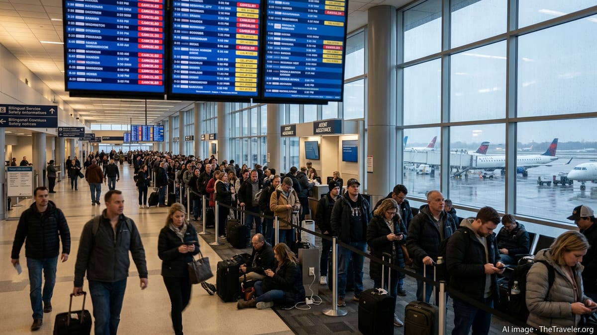
Hundreds of travelers at Grand Rapids’ Gerald R. Ford International Airport faced sudden cancellations and long delays this weekend, as severe weather and a strained national air system converged to create fresh chaos across U.S. skies.
Get the latest news straight to your inbox!
Severe Weather Turns Grand Rapids into a Midwest Bottleneck
Gerald R. Ford International Airport in Grand Rapids, Michigan, found itself at the center of mounting disruption as a powerful mid-March storm system swept across the Midwest and into the Great Lakes region. Heavy rain, pockets of freezing precipitation, and strong winds triggered a wave of schedule changes that quickly overwhelmed normal operations. Airlines preemptively canceled flights in and out of Grand Rapids, while those that remained on the schedule often left hours behind plan.
Publicly available weather outlooks for western and central Michigan highlighted the potential for ponding water, slick surfaces, and reduced visibility, prompting carriers to activate travel waivers for affected cities including Grand Rapids. These waivers encouraged passengers to change plans before conditions deteriorated, a step that tends to front-load cancellations but can reduce last‑minute strandings once storms peak.
As the storm intensified, aircraft and crews that would normally cycle through Grand Rapids became misaligned. In practical terms, that meant more planes parked at gates, longer lines at ticket counters, and an increasing number of passengers rebooked onto already crowded later flights. The airport’s role as a regional connector amplified the effect, since many itineraries through Grand Rapids involve tight connections to larger hubs.
Nationwide System Already Under Strain
The timing of the Grand Rapids disruptions proved particularly challenging because they hit a system that has already been under consistent pressure in recent weeks. Earlier in March, multiple U.S. hubs, including Chicago O’Hare and Atlanta, logged hundreds of cancellations and several thousand delays in a single day amid rounds of snow, thunderstorms, and low clouds that constrained runway capacity. Industry trackers have reported repeated spikes in nationwide cancellations, often driven primarily by weather rather than airline staffing or maintenance alone.
Separate incidents have also underscored how sensitive the network remains to any single point of failure. In the Washington, D.C., region, a strong chemical odor at a key radar and approach control facility recently prompted a temporary halt to flights at several major airports, creating delays that extended well beyond the local area. Federal aviation updates have similarly flagged ground stops and ground delay programs at other hubs when staffing, weather, or technical factors collide with busy schedules.
Against this backdrop, Grand Rapids’ weather-driven cancellations are feeding into a broader pattern of fragility. When a smaller connecting airport experiences major disruption on a day the rest of the network is already tight, even a modest number of scrubbed departures can translate into missed cross‑country connections and last‑minute rebookings spread across multiple airlines and cities.
How Travelers Are Being Affected on the Ground
For passengers in Grand Rapids, the immediate impact has been familiar to anyone who has flown during a major storm: departure boards filling with red “canceled” markers, lines at customer service counters stretching down concourses, and gate agents working through a backlog of rebooking requests. Many travelers report being offered itineraries that add extra stops or overnight connections in order to work around grounded aircraft and full flights over the next several days.
Because airlines anticipated ongoing Midwest weather problems through at least March 16, many have been encouraging digital self‑service rebooking via apps and websites to reduce congestion at the airport. Publicly available airline advisories indicate that standard change fees are being waived for eligible tickets, though fare differences can still apply once original travel dates pass and only a limited number of replacement seats remain.
The knock-on effects are visible far from Michigan. Travelers starting their journeys in warmer regions are encountering unexpected disruptions when their flights are routed through affected hubs or through regional cities such as Grand Rapids. Even when a local airport is not experiencing severe weather, aircraft heading there can face flow restrictions or holding patterns, causing arrival banks to shift and connecting passengers to miss onward legs.
What You Need to Know If You Are Flying
Travelers booked through Grand Rapids or other Midwest airports over the next several days are being advised, through airline and airport communications, to treat their itineraries as fluid rather than fixed. That starts with checking flight status repeatedly, beginning 24 hours before departure and continuing up to leaving for the airport, since same‑day schedule changes have become common as weather bands move and capacity forecasts are updated.
It is also important to understand the limits of what airlines are likely to provide in a weather‑driven event. When cancellations are attributed to storms or other conditions outside of carrier control, federal rules do not generally require hotels or meal vouchers, even for overnight disruptions. Some airlines choose to offer goodwill accommodations, but those decisions vary by company and by situation. Passengers may have stronger options for refunds or rebooking if a flight is significantly changed or canceled outright, compared with instances of shorter rolling delays.
Those with tight connections through Grand Rapids or other affected airports may want to proactively move to earlier flights where space is available, even if it means a longer layover. Published travel waivers typically allow a one‑time change within specified date and routing windows, and using that flexibility early can make the difference between securing a confirmed seat and waiting on standby during peak recovery periods.
Preparing for a Bumpy Late‑Winter Travel Pattern
Mid‑March has historically brought volatile weather in the central and eastern United States, and current outlooks suggest that pattern is likely to persist. Meteorologists are tracking additional storm systems that could bring a mix of heavy rain, late‑season snow, and severe thunderstorms across overlapping regions, each of which can disrupt aviation in different ways. Strong crosswinds, low ceilings, and lightning in the vicinity of airport grounds can all contribute to ground stops or reduced arrival and departure rates.
Federal aviation data consistently show that weather remains the primary cause of U.S. flight delays, and this latest wave of trouble in Grand Rapids fits that longstanding trend. For travelers, this means that flexible planning, careful monitoring of conditions, and an understanding of airline policies are increasingly essential, especially when routing through weather‑sensitive regions at the tail end of winter.
As airlines and airports work through the current backlog of disruptions centered on Grand Rapids and the broader Midwest, schedules are expected to stabilize gradually rather than snap back overnight. Passengers scheduled to fly in the coming days may still see lingering delays, so building extra time into connections and having contingency plans in place can help reduce the stress of an already turbulent travel season.