
More news on this day
A renewed Kona low winter storm is drenching Hawaii this weekend, unleashing dangerous flooding, road closures, power outages and mounting flight disruptions just as peak spring break travel brings thousands of visitors to the islands.
Get the latest news straight to your inbox!
Storm System Stalls Over Islands as Flood Risk Persists
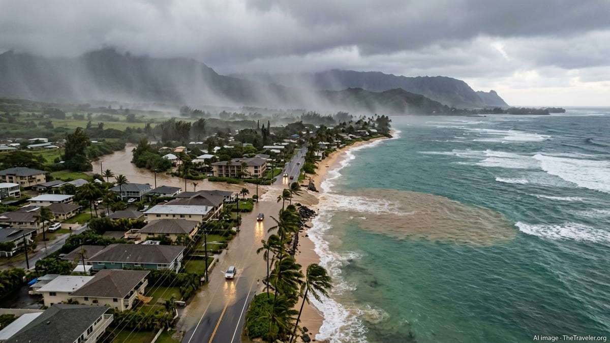
Publicly available forecasts from the National Weather Service indicate that a slow moving Kona low positioned to the west and north of the island chain is funneling deep tropical moisture over Hawaii, keeping bands of heavy rain parked over the state through at least late Sunday, March 22, 2026. The system follows an earlier round of severe weather a week ago, leaving soils saturated and waterways already running high.
Advisories describe widespread downpours, thunderstorms and localized severe weather as the storm pivots across Oahu, Maui County and the Big Island. A Flood Watch remains in effect for most of the state, with forecasters warning that even moderate showers could rapidly trigger new flash flooding because of the saturated ground. Leeward resort areas that usually see calmer, drier spring conditions have not been spared, with pockets of intense rainfall reaching popular coastal corridors.
State documents show that a formal emergency proclamation was issued in early March in anticipation of the Kona low pattern, enabling rapid deployment of resources and confirming the expectation of heavy rain, damaging winds and possible road closures statewide. That outlook has now materialized, turning what is typically a busy late-winter travel period into an unusually hazardous stretch for both residents and visitors.
Significant Flooding, Power Outages and Road Closures Reported
Recent coverage from Honolulu-based outlets and national wire services describes some of the worst flooding in more than two decades on Oahu, with muddy waters inundating streets, lifting homes from their foundations and sweeping vehicles off roadways. North Shore communities world famous for big-wave surfing have instead been grappling with chest-deep water in low-lying areas and fast-moving runoff pouring out of the Koolau Range.
Reports also highlight growing concern around aging flood control infrastructure, including a more than century-old dam north of Honolulu that has been placed under close scrutiny as upstream catchments fill and spillways run high. While water levels have fluctuated, communities downstream have faced repeated evacuation advisories as engineers monitor structural conditions and additional rainfall totals.
Utility updates indicate that tens of thousands of customers across Oahu and Maui County lost electricity at various points during the week as saturated hillsides, high winds and swollen streams brought down trees and power lines. On Oahu, a major transmission corridor linked to the H-3 Freeway has required emergency repairs, contributing to a full closure of the interstate in one direction and adding to congestion on alternate cross-island routes.
Beyond the main population centers, social media posts and local briefings describe washed-out shoulders, rockfall-prone cliff sections and standing water along scenic coastal roads, particularly on the windward sides of the islands. Popular drives that normally feature postcard views have instead become lengthy, slow-moving slogs punctuated by unplanned detours and temporary traffic stoppages.
Flight Delays Mount as Spring Break Crowds Arrive
The timing of the storm has been particularly disruptive for airline operations, as March brings one of the busiest travel periods of the year for Hawaii. Public flight-tracking data and traveler reports point to cascading delays at Daniel K. Inouye International Airport in Honolulu and other island gateways, including Kahului on Maui and Ellison Onizuka Kona International Airport on the Big Island.
Low cloud ceilings, bouts of intense rain and gusty crosswinds have periodically reduced visibility and limited runway use, forcing ground holds and slower arrival and departure rates. Aircraft repositioning has also been impacted when interisland routes encounter thunderstorms or low-level wind shear, leaving crews and equipment out of position for later flights.
The knock-on effects have been felt most acutely by spring break visitors trying to connect between islands for multi-stop itineraries. Travelers have reported missed onward flights, unplanned overnight stays near airports and long waits at customer service counters as carriers work through backlogs created by repeated weather holds. With the storm still evolving, airline schedules remain fluid, and previously on-time flights can shift to delayed status with little warning.
At the same time, airport terminals have grown noticeably more crowded as incoming vacationers overlap with stranded passengers from earlier cancellations. Seating and food options have been stretched, and access to rental cars and hotel rooms near major airports has tightened as travelers scramble to rebook their plans around the unsettled weather.
Beach Conditions, Tours and Outdoor Plans Disrupted
Even where skies have intermittently cleared, beach and ocean conditions remain problematic. Community advisories and local health guidance warn that heavy runoff has sent mud, debris and urban pollution into coastal waters around multiple islands, creating extensive brown-water plumes. Such conditions typically increase the risk of illness and can attract sharks closer to shore, leading many lifeguards and local residents to urge caution or recommend staying out of the ocean altogether until water quality improves.
Brown-water advisories, combined with rough surf and strong currents in some areas, have forced the suspension or modification of popular activities such as snorkeling excursions, beginner surf lessons and small boat tours. Operators that are still running have in many cases shifted routes or shortened itineraries, emphasizing safety briefings and contingency plans for quickly changing conditions.
On land, closures of hiking trails and backcountry access roads have expanded as land managers assess damage from landslides, falling rocks and eroded switchbacks. Trails that climb into the Koolau and West Maui Mountains, along with routes that cross streambeds or skirt waterfall pools, have been repeatedly flagged as hazardous due to sudden rises in water levels and unstable slopes.
For many visitors, the combination of closed trails, murky beaches and gridlocked roads has significantly reshaped the typical spring break experience. Visitor forums and travel updates reflect a shift toward indoor activities, cultural attractions and resort-based amenities as travelers seek safer alternatives while the storm system lingers.
What Travelers Should Expect in the Days Ahead
Forecast discussions suggest that the Kona low will gradually weaken and move away from the islands early in the new week, but lingering showers and localized downpours are likely to persist even after the most intense rainfall subsides. With waterways already swollen and slopes saturated, the risk of additional flash flooding, debris flows and isolated landslides is expected to remain elevated for some time.
Transportation networks will likely take longer to fully recover than the weather itself. Damaged infrastructure, ongoing power restoration and the need to clear mud and rock from roads will continue to affect driving conditions on several islands. Airlines typically require additional time to reset schedules and reposition aircraft after a disruptive weather pattern, meaning that intermittent delays and scattered cancellations could continue even after blue skies return.
Travel industry updates encourage spring break visitors to maintain flexible plans, build in extra time when moving between islands and confirm the status of flights, tours and key roadways before departing hotels or vacation rentals. Those planning outdoor adventures are being urged to check local weather briefings frequently, pay close attention to any posted closure signs and remain prepared to pivot to backup activities if conditions deteriorate.
For now, Hawaii remains firmly under the influence of a late-season winter storm pattern more reminiscent of mid-January than late March. As the Kona low finally begins to pull away, the islands will begin the slow process of recovery, even as travelers and residents alike keep a wary eye on the skies during what has become an unexpectedly turbulent spring break season.