
More news on this day
A powerful Kona storm system is battering Hawaii with flash flooding, summit snow and damaging winds, prompting emergency declarations, campground closures and growing flight disruptions as authorities urge travelers to check their flight status before heading to the airport.
Get the latest news straight to your inbox!
Storm System Slams Islands With Multiple Weather Hazards
The slow moving Kona low parked near the islands this week is delivering an unusual mix of extreme conditions, from torrential rain at sea level to heavy snow and high winds on Hawaii Island’s tallest peaks. The National Weather Service in Honolulu has a statewide flood watch in effect through at least Saturday, warning that repeated downpours could trigger flash flooding, landslides and road washouts on every major island.
Rainfall rates topping 2 inches an hour have already been reported on Kauai and Oahu, with forecasters cautioning that the heaviest, most persistent bands may shift east toward Maui County and Hawaii Island as the system drifts. Low lying neighborhoods, stream valleys and coastal roads on windward and leeward sides alike are at risk, since Kona storms tend to funnel moisture into typically drier regions.
At higher elevations, the same system is pulling in colder air over the Big Island summits. A winter storm watch is in effect for Mauna Kea and Mauna Loa above roughly 12,000 feet, where forecasters say several inches of snow and ice are possible along with severe wind chills. High wind alerts are also posted for other high terrain, including Haleakala on Maui, as gusts climb well above 60 miles per hour.
State officials say the combination of hazards raises the potential for power outages, downed trees, rockfalls and rapidly changing travel conditions across interisland highways. Residents and visitors are being urged to avoid driving through ponded water, heed barricades and be prepared for sudden road closures as the storm evolves.
Closures and Safety Alerts Hit Popular Visitor Areas
As the forecast worsened, Hawaii’s Department of Land and Natural Resources announced the closure of all state run camping areas on Oahu, Maui and Molokai starting early Wednesday and continuing until conditions improve. The move affects beach parks and forest reserves popular with both residents and visitors planning spring break trips.
Officials said they acted out of concern that saturated ground, falling branches and rising streams could make remote campsites hazardous or cut off evacuation routes with little warning. Day use access to some trails, lookouts and coastal areas may also be restricted if flooding or landslides threaten parking lots and access roads.
County emergency managers across the state have urged people to identify alternate routes, assemble basic storm supplies and stay alert for localized alerts about neighborhood closures. Visitors staying in hotels and vacation rentals have been advised to follow instructions from property staff and to avoid venturing onto closed beaches, near swollen streams or into cloud covered mountain areas.
On Hawaii Island, authorities are warning sightseers to stay away from summit roads if conditions deteriorate, noting that snow, black ice and severe crosswinds can make narrow access routes to Mauna Kea and Mauna Loa extremely dangerous, even in four wheel drive vehicles.
Travelers Face Flight Delays and Weather Related Disruptions
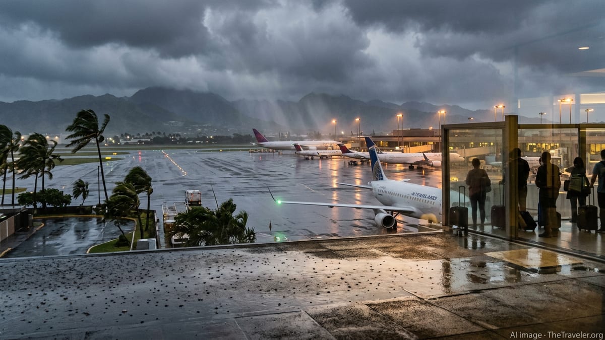
The severe weather is already rippling through Hawaii’s air travel network. A travel advisory issued for airports across the state on Wednesday urged passengers to check with their airline before leaving for the airport, warning that high winds and low visibility could cause delays, diversions or cancellations on both interisland and mainland routes.
Airlines serving Honolulu, Kahului, Lihue, Hilo and Kona reported they were monitoring conditions closely as bands of heavy rain and gusty crosswinds moved across approach paths and runways. Cargo carriers and passenger airlines alike have cautioned that schedules may change throughout the day as the storm’s strongest squalls pass over different islands.
Industry observers say the most vulnerable flights are shorter interisland segments, where even modest delays or temporary ground stops can cascade through daily rotations. Morning departures are at particular risk when overnight thunderstorms or wind shifts force crews to hold aircraft on the ground until conditions improve.
At Daniel K. Inouye International Airport in Honolulu, airport officials are advising passengers to arrive with extra time, expect longer lines at check in and security if flights bunch up after weather holds, and prepare for potential gate changes as airlines juggle aircraft and crews.
Waivers, Rebooking Options and What Passengers Should Do Now
Several major carriers have begun offering weather waivers for travel to, from or within Hawaii over the coming days, allowing passengers to change dates without typical fees if their itinerary falls within the advisory window. Some policies extend rebooking options into next week to account for the storm’s slow movement and the possibility of lingering disruptions once skies begin to clear.
Travel advocates stress that the most important step for anyone flying into or out of the islands now is to monitor their reservation directly through the airline’s app, website or customer service alerts. Because this event is weather related, compensation rules differ from disruptions caused by mechanical issues, and travelers may have more flexibility on date changes than on hotel or meal vouchers.
Passengers whose flights are significantly delayed or canceled should keep records of messages from airlines, save boarding passes and receipts, and confirm whether a schedule change qualifies them for a full refund instead of travel credit. Those booked through online travel agencies or third party platforms may need to work through those companies to make changes, which can take extra time during major weather events.
For visitors already in Hawaii and facing extended stays due to canceled outbound flights, tourism officials recommend contacting accommodations early about possible extensions, as demand for extra nights can climb quickly when a broad weather system affects multiple islands at once.
Planning Ahead as the Storm Lingers Into the Weekend
Forecasters say the Kona low is likely to linger near the state through at least the weekend, meaning periods of heavy rain, gusty winds and rough seas could continue even between brief moments of sunshine. That uncertainty is complicating travel plans for vacationers arriving for spring break, as well as residents heading to the mainland or other islands for work, medical appointments or family events.
Weather specialists note that Kona storms are notoriously difficult to predict in detail until a day or two in advance, so short term adjustments to tours, hikes and scenic drives may be the safest approach. Travelers with flexibility are being encouraged to schedule more indoor or urban activities over the next several days and to stay ready to pivot as new advisories are issued.
For those with imminent departures, experts recommend building redundancy into plans: charging devices fully, downloading boarding passes in advance, packing medications and essentials in carry on bags and leaving extra time for traffic delays on flooded or debris strewn roads leading to the airport.
Even as the storm showcases Hawaii’s dramatic weather contrasts, from snow capped volcanoes to rain lashed beaches, officials are emphasizing that patience and preparation can help keep trips safe. With conditions still evolving, the clearest piece of advice remains simple for anyone flying in or out of the islands over the next few days: verify your flight status before you leave for the airport, and be prepared for plans to change.