
More news on this day
Fresh winter storm alerts across parts of the United States are warning of heavy snowfall approaching 10 inches in some areas, with public bulletins strongly advising residents and visitors to delay all nonessential travel as hazardous conditions develop.
Get the latest news straight to your inbox!
Warnings Highlight Risk of 10 Inches of Heavy Snow
Recent winter storm bulletins from multiple regions indicate that snow totals between 6 and 10 inches are possible in localized bands, particularly along favored lake and mountain corridors. In several advisories, language urging people to delay all travel has been highlighted as forecasters point to a combination of heavy, wet snow and gusty winds that can rapidly deteriorate road conditions.
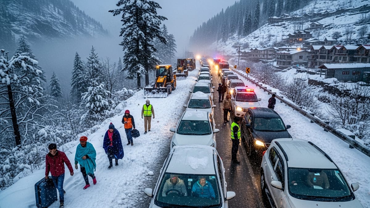
Publicly available information from recent winter weather briefings shows that travel warnings are most acute where snowfall rates may briefly exceed 1 inch per hour. Under these conditions, even well-treated highways can quickly become snow covered and slick, while visibility drops sharply for drivers.
In earlier storms this season, winter storm warnings that projected similar 8 to 12 inch totals were accompanied by explicit cautions that motorists should consider postponing trips due to the risk of spinouts, jackknifed trucks and blocked interchanges. Those past events are being used as a reference point in current messaging urging travelers to take the new alerts seriously.
Travel and transportation advisories note that snowfall amounts near the 10 inch mark tend to strain local plowing operations, especially during peak commuting hours or when snow is heavy and dense. That combination amplifies the potential for gridlock, fender benders and long delays that can cascade across regional transportation networks.
Road Conditions Expected to Deteriorate Quickly
Reports from previous winter storm periods this year show that when heavy snow coincides with strong winds, roads can shift from merely wet to fully snow packed and icy within an hour. In northern states, state transportation updates have documented stretches of highway becoming snow compacted with multiple crashes reported as motorists encountered whiteout pockets and rapid accumulation.
During recent winter storm warnings, local transportation departments recorded visibility below a quarter mile at times, as gusts lofted powdery snow across open stretches of interstate. This pattern is likely to repeat where the latest bands of heavy snow coincide with exposed terrain, making conditions particularly treacherous for high profile vehicles and for drivers unfamiliar with winter roads.
Even where snowfall totals remain closer to 4 to 6 inches, earlier storm summaries emphasize that peak snowfall rates and timing can be more important than the final number. When the heaviest burst of snow aligns with morning or evening rush hours, backups can form quickly, emergency responders can struggle to reach crashes, and stranded vehicles can slow plows attempting to clear main arteries.
Publicly available advisories consistently recommend that, if travel cannot be avoided, drivers carry winter emergency kits with warm clothing, food, water and phone chargers. Recent storm accounts have underscored that relatively short trips have turned into multi hour ordeals when crashes or disabled vehicles clog main routes.
Air and Rail Travelers Face Delays and Cancellations
The impacts of heavy snow approaching 10 inches extend well beyond roads, with air and rail passengers also being urged to prepare for schedule disruptions. In comparable storms earlier this season and in recent years, airlines have issued travel waivers across affected regions, allowing passengers to rebook without change fees as snow and wind reduced visibility below safe landing thresholds.
Large winter systems that produced more than a foot of snow in some hubs have previously led to dozens of flight cancellations and widespread delays, with aircraft and crews out of position long after the heaviest snow ended. Current alerts suggest that even if the latest system produces slightly lower totals in some cities, the combination of runway clearing, deicing operations and crew time limits can still ripple through airline schedules.
Rail operations have also been affected in past heavy snow events. Publicly available reports from winter storms show that snow and ice buildup on tracks and switches can slow commuter and intercity trains, while strong winds raise the risk of downed trees and power lines along key corridors. In at least one recent European winter storm, long distance rail services were temporarily halted across a broad region as heavy snow and ice made operations unsafe.
Travel commentators note that passengers with flexible plans are often better served by rescheduling before a storm peaks rather than waiting at terminals where capacity for rebooking may be limited. Recent storm coverage has highlighted crowds sleeping in airport concourses and stations after underestimating the scale and duration of weather related disruption.
Travel Industry and Local Businesses Brace for Impact
Tourism and travel related businesses in snow affected regions are again preparing for a short term hit as winter alerts return. Travel sector updates from previous heavy snow episodes describe hotels shifting from leisure guests to stranded travelers, with occupancy surging near major highways and airports even as resort bookings soften.
In mountain and ski regions, fresh snow can be a draw, but timing remains critical. If 8 to 10 inches fall in a single day with limited visibility and high avalanche danger in backcountry areas, resorts may temporarily restrict access to certain terrain while road closures or chain requirements limit arrivals. Industry coverage from earlier storms this season notes that some destinations have seen late arriving crowds once main roads were cleared and conditions stabilized.
Urban centers facing heavy snow and strong travel advisories often see restaurants, retail and attractions experience sudden cancellations as residents opt to stay home. At the same time, grocery stores and fuel stations can experience brief surges in demand as people stock up ahead of the storm. Past storm recaps have described this pattern repeating across multiple regions, from the Upper Midwest to the Northeast.
Travel analysts suggest that visitors adjust itineraries to emphasize walkable, in town activities once the storm has passed, rather than planning long drives during or immediately after significant snowfall. Public messaging ahead of the latest system indicates that this strategy can reduce strain on road crews and emergency services while still allowing trips to continue with fewer risks.
Safety Guidance Urges Delaying All Nonessential Trips
Across recent winter events that brought totals near or above 10 inches, strongly worded safety guidance has become more common. Phrases advising people to consider delaying all travel have appeared repeatedly in storm related bulletins as agencies seek to reduce crashes, injuries and gridlock at the height of the weather.
Publicly available winter preparedness annexes and storm summaries stress that avoiding travel during the most intense period of snowfall is among the most effective ways to prevent accidents. This approach allows plows to work more efficiently, reduces demand on emergency responders and lessens the likelihood that drivers will be stranded in life threatening wind chill or low visibility.
For travelers already on the road system, guidance based on earlier storms recommends identifying safe stopping points before conditions deteriorate, such as lodging near interchanges or community shelters that may open during prolonged events. Motorists are also urged not to rely solely on navigation apps, which may route them onto unplowed secondary roads or seasonal tracks.
With another round of winter weather poised to deliver heavy snow and localized 10 inch totals, the central message from recent storm experience is clear. Those who can postpone nonessential trips until after plows and sunshine have improved conditions are likely to face fewer disruptions, while those pressing ahead in the midst of the storm assume a significantly higher level of risk.