
More news on this day
Travelers across parts of the United States are being urged to reconsider plans as forecasters warn that a fast‑moving winter storm could dump around five inches of snow, creating whiteout conditions and periods of “nearly impossible” travel on key highways.
Get the latest news straight to your inbox!
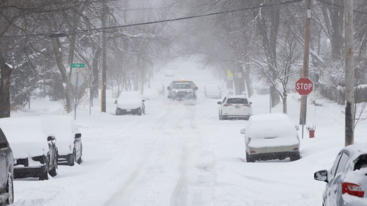
Image by Newsweek
Storm Track Targets Key Travel Corridors
Forecast discussions from multiple National Weather Service offices indicate that a compact but intense winter system is tracking across portions of the Midwest and interior Northeast, drawing in colder air and setting up a corridor of heavy snow along major interstates. Recent forecast packages highlight a swath where totals of 3 to 6 inches are expected, with localized amounts exceeding 5 inches where snow bands persist the longest.
Areas favored include stretches of interstate routes that funnel regional traffic toward major hubs, raising concerns for both long‑haul truckers and holiday‑weekend motorists. Publicly available outlooks describe a narrow zone of strongest lift and moisture where snowfall rates could briefly exceed one inch per hour, quickly covering previously treated roadways and overwhelming plow operations.
In several recent storms of similar strength, snow totals around 5 to 8 inches have been enough to trigger winter storm warnings and lake‑effect advisories, with transportation agencies reporting multiple spinouts and jackknifed trucks when visibility suddenly dropped. Forecasters are pointing to those recent events as a guide for what travelers might expect as this storm crosses the region.
Why Five Inches Can Shut Down the Roads
While a forecast of “around five inches” may sound manageable to seasoned winter drivers, transportation safety analyses show that the combination of snowfall rate, timing and wind can turn a moderate event into a high‑impact one. When snow falls faster than about an inch per hour, road salt becomes less effective and plows struggle to keep lanes clear, especially on multi‑lane highways and exposed overpasses.
Definitions used by U.S. weather and emergency management agencies note that three to five inches of snow in a short window is often enough to justify winter storm alerts, particularly when paired with wind gusts over 30 miles per hour. Under those conditions, freshly fallen powder is easily lofted into the air, producing whiteout or near‑whiteout conditions where drivers can lose sight of lane markings, brake lights and even roadside barriers.
Recent state hazard annexes and winter storm case studies describe how five to eight inches of heavy, wind‑blown snow has repeatedly produced “difficult to nearly impossible” travel, with traffic slowing to a crawl or coming to a complete standstill on rural stretches of interstate. The risk is amplified at night, when contrast is lower and drivers are more likely to encounter black ice hidden beneath drifting snow.
Warnings Highlight ‘Difficult to Nearly Impossible’ Travel
Current winter storm and snow warnings issued for affected counties emphasize that travel may become “very difficult to nearly impossible” during the peak of the event, particularly north of key highway corridors and in higher terrain. Recent alerts for similar systems have used nearly identical language to underscore the risk of sudden deterioration in road conditions, even for short local trips.
Forecast discussions reference the potential for snowfall rates of two inches per hour within the heaviest bands, supported by strong lift and focused moisture. In these zones, forecasters expect rapid accumulation on untreated surfaces, while gusty winds could create near‑whiteout conditions, especially in open country, along rivers and over ridge tops.
Publicly available warning texts also stress that plowed roads can become snow‑covered again within minutes when bands pivot over the same area, leading to repeated cycles of clearing and rapid refreezing. Travel advisories encourage drivers to delay non‑essential trips, adjust itineraries away from peak snowfall, or be prepared for long delays if they choose to remain on the road.
Impacts for Air, Rail and Local Transit
Although the projected snow totals are modest compared with recent blizzards that buried parts of the Northeast under more than two feet of snow, transportation planners note that even 5 to 8 inches can ripple through air and rail networks. Airlines commonly preemptively trim schedules when winter storm warnings appear along major approach paths, both to maintain safety margins and to prevent aircraft and crews from becoming stranded out of position.
Rail services through affected corridors may also experience slower operations if blowing and drifting snow reduce visibility at grade crossings or obscure signals. In some recent storms, commuter rail and regional bus operators in similar conditions have shifted to reduced schedules, citing both roadway hazards and difficulty keeping platforms, steps and parking lots clear of compacted snow and ice.
Local transit systems in smaller cities are particularly vulnerable when snowfall rates surge during the morning or evening commute. With limited fleets and long routes, buses can quickly fall behind schedule as they navigate slippery hills and unplowed side streets, leaving riders waiting in increasingly harsh conditions as wind chills drop.
Advice for Travelers and Local Communities
Emergency management guides for winter weather consistently recommend that travelers avoid being on the road during periods flagged for heavy snow and near‑zero visibility. When warnings call out the potential for “nearly impossible” travel, motorists are urged to reroute or reschedule if at all feasible, especially on rural highways where services are sparse and towing operations may be delayed.
For those who cannot delay, safety checklists advise keeping fuel tanks at least half full, charging mobile phones in advance, and packing winter kits with warm clothing, blankets, food, water and a flashlight. Recent state guidance also highlights the value of monitoring official travel and road condition services by phone or broadcast updates before departing, rather than relying solely on navigation apps.
Communities in the path of the storm are being encouraged, through public information campaigns, to check on neighbors who may be vulnerable to power outages or unable to shovel heavy, wet snow. As this latest system approaches with a forecast of roughly five inches in its most intense corridor, the consistent message from winter preparedness materials is clear: treat the warnings seriously, and stay off the roads when conditions begin to tip from merely difficult toward nearly impossible.