
More news on this day
A rapidly intensifying winter storm is triggering heavy snow warnings across parts of the central and eastern United States, with forecasters expecting up to 5 inches of accumulation in some travel corridors and publicly available information indicating that road conditions may become nearly impossible for several hours.
Get the latest news straight to your inbox!
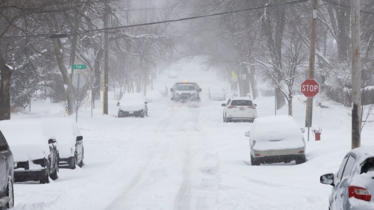
Image by newsweek.com
Storm Track Targets Key Travel Corridors
Recent forecasts indicate that a compact but potent winter system is moving east from the Plains into the Midwest and interior Northeast, drawing in colder air and setting up a swath of moderate to heavy snowfall along major interstates. The heaviest band is expected to form late today into tonight, affecting stretches of highways that carry significant commuter and freight traffic.
National forecast discussions show that snow totals are likely to reach 3 to 5 inches in a broad zone, with localized higher amounts where narrow snow bands persist over the same locations. Even where totals remain near the lower end of that range, the combination of snowfall intensity, cold pavement, and strong winds is expected to deteriorate conditions quickly once precipitation begins.
Travel hubs in several states are bracing for rapidly changing conditions, with visibility projected to fall below one-quarter mile at times during peak bands. These impacts are expected to align with evening commuting hours in some metro areas, heightening the risk of spinouts, multi-vehicle collisions, and long delays on untreated or partially treated roads.
Air travel is also at risk of disruption as the storm crosses multiple time zones. Airlines commonly preemptively adjust schedules in similar setups when forecasts call for fast-accumulating snow and crosswinds near runway thresholds, and passengers are being advised through public messaging to monitor their flight status and consider flexible itineraries.
Why 5 Inches Can Mean ‘Nearly Impossible’ Travel
Although a 5 inch snowfall may sound manageable in regions accustomed to winter weather, the timing and character of the snow can transform highways into hazardous corridors within a short window. Forecast guidance suggests that much of the accumulation could occur in a six-hour period or less, leading to snowfall rates near one inch per hour at times, which outpace typical plowing and treatment cycles on busy urban and suburban roadways.
When snow falls this quickly, tire tracks compact it into a slick layer on high-traffic routes, particularly where pavement temperatures hover around freezing. If winds increase at the same time, blowing and drifting can obscure lane markings, hide black ice, and create abrupt snow piles along shoulders and exits. These factors combine to make braking distances unpredictable, increasing the likelihood of chain-reaction crashes when drivers maintain normal speeds.
Public guidance from recent winter storms with similar intensity has warned that heavy snow and blowing snow can produce short-lived but severe whiteout conditions where travel becomes nearly impossible, even without extreme totals. Drivers may suddenly lose sight of vehicles just ahead, while plows struggle to maintain visibility and keep up with accumulation on primary and secondary roads.
In rural and open areas, even modest snow depths can drift significantly across exposed stretches, such as overpasses and elevated sections. This creates alternating bare pavement and deep, wind-carved drifts that can catch drivers off guard, especially at night or in low-contrast light conditions common during winter storms.
Expected Impacts on Roads, Rail and Air Travel
Transportation planners anticipate that the most immediate impacts will be felt on roads, where a mix of heavy snow, gusty winds, and falling temperatures can quickly overcome pre-treatment efforts. Bridges, overpasses, and ramps are expected to ice first, and public advisories are already emphasizing the heightened risk of spinouts and jackknifed trucks in these locations once the snow intensifies.
Commuter bus systems in affected cities may see delays or temporary route adjustments as conditions worsen along hilly or narrow streets. In prior storms of this type, operators have shifted to main-artery service during peak snowfall to reduce the chance of vehicles becoming stuck on side streets, and similar contingency plans are likely in place as this system approaches.
Rail travel has typically been more resilient during moderate snowfalls, but heavy bursts can still lead to slower speeds, track-switch issues, and reduced visibility at grade crossings. Passengers are being encouraged through general winter weather advisories to build extra time into their journeys and to check for schedule changes as conditions evolve.
At airports, strong crosswinds and low visibility in snow bands can prompt ground stops or deicing backlogs, with ripple effects across the national network. Past winter storms with comparable snowfall and wind profiles have produced hundreds of delays and cancellations in a single day, and current forecasts suggest a similar pattern could emerge, especially at mid-continent and Northeast hubs.
Guidance for Drivers and Travelers Caught in the Storm
Publicly available safety guidance for winter weather emphasizes that the safest option during periods of intense snowfall is to delay nonessential travel until plows and treatment crews have had time to restore road surfaces. When that is not possible, travelers are advised to slow down significantly, allow for much longer following distances, and avoid sudden lane changes that can cause loss of control on hidden ice or packed snow.
Drivers heading into regions within the heavy snow warning area are encouraged to carry a fully charged mobile phone, extra warm clothing, blankets, and a small supply of food and water in case of extended delays. It is also recommended that fuel tanks be kept at least half full to allow vehicles to idle safely if traffic comes to a standstill, and to reduce the risk of fuel-line freeze in colder pockets behind the storm.
Those using rental vehicles or driving in unfamiliar cities are being urged in general public messaging to rely on major roads, which are typically treated and plowed first, rather than cutting through minor side streets. Navigation apps can provide real-time congestion data, but winter safety resources caution that the shortest route is not always the safest during active snowfall.
Travelers with flights scheduled during the storm period may wish to explore earlier departures or later rebooking where options exist, particularly if their itineraries involve tight connections through regions expecting the heaviest snowfall. Keeping carry-on essentials such as medications, chargers, and basic toiletries readily accessible can help mitigate inconvenience if weather-driven changes lead to overnight delays.
Looking Ahead as the System Moves East
Forecast models indicate that the storm will continue eastward after the initial burst of heavy snow, bringing a tapering of precipitation but leaving behind a broad area of slick roads and lingering snowpack. In more populated regions, the first clear, cold morning after the storm often brings a new wave of collisions as sun glare reflects off ice and drivers encounter refrozen meltwater in shaded stretches and at intersections.
Transportation agencies typically pivot from active plowing to cleanup and widening operations at this stage, pushing back snowbanks to restore full lane widths and improve sightlines. Travelers can still expect intermittent lane closures and narrowed shoulders during these efforts, particularly on secondary highways and in suburban corridors where parked vehicles complicate snow removal.
For those planning trips in the coming days, long-range outlooks suggest that colder-than-normal temperatures behind the storm may preserve snow and ice on untreated surfaces longer than usual. This is particularly relevant for early morning and overnight travel, when black ice can form even after daytime highs climb above freezing.
As the system exits, attention is likely to shift to the next round of weather disturbances lining up in the Pacific and central United States, a common midwinter pattern. For travelers, that means this episode of heavy snow and nearly impossible travel could be one in a series of disruptive events, making advance planning, flexible itineraries, and close attention to evolving forecasts an essential part of winter mobility.