
More news on this day
A powerful late-season winter storm is sweeping across the western United States, with forecasters warning of heavy snow, fierce winds and hazardous travel from the Cascades of Washington and Oregon to the mountain passes of Montana and Wyoming over the coming days.
Storm System Targets Cascades and Northern Rockies
The National Weather Service has issued a patchwork of winter storm warnings, heavy snow warnings and winter weather advisories across parts of Washington, Oregon, Montana and Wyoming as a robust Pacific system pushes inland this week. Forecasters say the storm will intensify as it taps colder air over the northern Rockies, setting the stage for periods of intense snowfall at higher elevations and quickly changing conditions along key travel corridors.
In Washington, warnings are focused on the Cascades and interior highlands, where several waves of moisture are expected to drop heavy snow through at least Friday, March 13. Some mountain locations could see two to four feet of accumulation, with locally higher totals on west-facing slopes as moisture-laden air is forced upward over the terrain.
Further south, elevated terrain in Oregon is also in the crosshairs, with mountain passes along major east–west routes expected to see rapid snowfall rates and gusty winds. As the system pushes east into the northern Rockies, forecasters warn that ranges in western and south-central Montana and northwest Wyoming could see significant new snow, adding to an already active winter pattern.
While lower valleys and major cities may see a mix of rain and wet snow, the combination of cold air and upslope flow will keep snow levels low enough for travel disruptions in many mountain communities and on higher stretches of interstate highways.
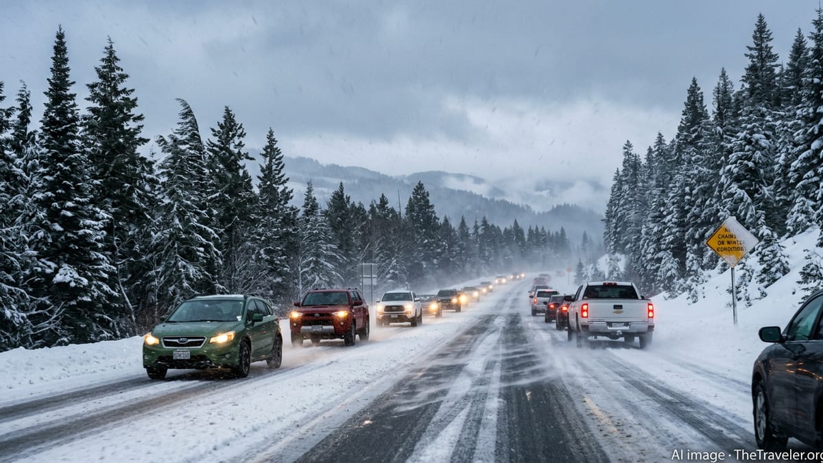
Travel Disruptions Likely on Key Highways and Mountain Passes
With heavy snow and strong winds expected to overlap along major travel routes, transportation officials are urging drivers to be prepared for rapidly deteriorating conditions. In Washington and Oregon, mountain passes along critical trans-Cascade routes are likely to face chain requirements, intermittent closures and long delays as plows struggle to keep up with snowfall rates.
Further inland, high-impact travel is anticipated along stretches of Interstate 90 and other regional highways in Montana and northern Wyoming, where blowing and drifting snow could reduce visibility to near zero at times. Sections of high-elevation roads may become impassable for periods if whiteout conditions develop, particularly overnight and early in the morning when temperatures are coldest.
Authorities are advising anyone planning to drive through affected areas this week to watch for sudden changes in weather and road reports. Periods of heavy snow may be interspersed with brief lulls, which can give a misleading impression of improvement before the next band of intense precipitation arrives.
Air travel may also be affected, particularly at regional airports that serve mountain communities and smaller cities near the Cascades and northern Rockies. Low clouds, snow showers and gusty crosswinds can lead to delays, diversions or cancellations, and travelers are being urged to check flight status frequently and allow extra time for ground transportation to and from airports.
Who Is Most at Risk as Conditions Deteriorate
Forecasters stress that the greatest risk lies with travelers who underestimate how quickly conditions can worsen once snow begins to fall in earnest. Drivers attempting to cross the Cascades or northern Rockies with summer tires, limited fuel or no winter kit are especially vulnerable if they encounter road closures, spinouts or unexpected detours.
Rural residents and visitors heading to remote cabins, ski areas or national parks in Washington, Oregon, Montana and Wyoming may face additional challenges. In these areas, cell coverage can be unreliable, and a stuck vehicle can quickly become a life-threatening situation if temperatures drop and winds increase. Local officials recommend postponing discretionary backcountry trips until the storm has passed and avalanche and road conditions have stabilized.
Power outages are another concern where heavy, wet snow combines with strong winds, particularly in forested foothill regions. Downed branches and power lines can leave communities without heat or communications for hours or longer. Travelers relying on electric vehicle charging stations in rural corridors should plan carefully, as outages or road closures could limit access to charging points.
Even experienced winter drivers are being urged to adjust their behavior, with transportation agencies emphasizing slower speeds, greater following distances and a readiness to turn back if conditions worsen unexpectedly along the route.
What Travelers Should Do Now
Emergency managers across the affected states are urging travelers to plan ahead rather than react once the storm is already underway. Anyone with flexibility is being encouraged to delay nonessential trips through mountain areas until after the heaviest snow and strongest winds have passed later in the week.
For those who must travel, experts recommend checking the latest state transportation maps, weather forecasts and live road cameras before departure and at regular intervals along the way. Having multiple route options in mind can help drivers avoid the most heavily impacted passes or detours if closures arise with little notice.
Vehicles should be fully winter-ready, with appropriate tires or chains, a full fuel tank and an emergency kit that includes warm clothing, blankets, food, water, a shovel, traction aids and a power bank for mobile devices. Travelers are also encouraged to let someone know their route and expected arrival time, particularly when crossing rural stretches of Montana and Wyoming or isolated mountain roads in Washington and Oregon.
Those flying into the region in the coming days should consider building extra time into their itineraries for missed connections, rebookings or slow ground transfers. Flexible tickets and travel insurance that covers weather-related disruption may provide added peace of mind during this period of heightened storm activity.
Looking Ahead as Winter Hangs On
Although the calendar is inching toward spring, meteorologists note that March can still deliver some of the most disruptive winter storms of the season across the Pacific Northwest and northern Rockies. The current setup, with a train of Pacific systems and pockets of cold air over the interior West, provides plenty of fuel for additional snow events even after this week’s storm winds down.
Snowpack in key mountain watersheds has been closely watched this winter, and while the new snow will be welcomed by ski areas and some water managers, it also raises the risk of avalanches and late-season travel disruptions. Backcountry users are being urged to consult local avalanche centers frequently as heavy new snow loads weak layers that have developed over the season.
For travelers, the message from forecasters and transportation officials is clear: treat this week’s storm as a serious winter weather event, even if conditions seem manageable at lower elevations. By staying informed, allowing extra time and being willing to change plans, visitors and residents alike can reduce their risk as heavy snow and strong winds sweep across Washington, Oregon, Montana and Wyoming.