
More news on this day
Falling water levels at Haweswater Reservoir in England’s Lake District have revealed the stone outlines of Mardale Green, a once-inhabited valley village deliberately flooded in the 1930s to create a vital water supply for northwest England.
Get the latest news straight to your inbox!
Rare glimpse of a drowned community
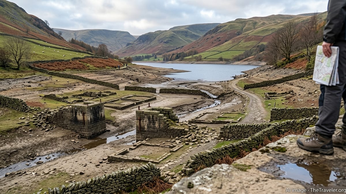
Recent dry conditions have pushed Haweswater’s waterline unusually low, uncovering long-submerged features of Mardale Green that are normally hidden beneath the surface. Reports from local outlets and visitor accounts describe exposed dry stone walls, bridge abutments and building foundations tracing the former streets and farmsteads of the valley settlement.
The reappearance offers a rare, three-dimensional sense of the scale of the village that once occupied this remote Cumbrian valley. At particularly low points, sections of former field systems and trackways become visible, allowing visitors to walk across ground that has been underwater for most of the past eight decades.
Coverage from regional heritage and tourism organisations indicates that the current exposure is among the more striking in recent years, inviting renewed attention to the story of how Mardale Green was sacrificed in the name of urban water security.
How Haweswater swallowed Mardale Green
Mardale Green stood at the head of the Mardale valley until the early twentieth century, when Manchester Corporation sought new upland sources to meet growing demand from industrial cities in the northwest. Parliamentary approval in 1929 paved the way for construction of a concrete dam that transformed a natural lake into Haweswater Reservoir.
The dam’s completion in the mid 1930s raised the water level by around 30 metres, inundating farms, homes and the local inn, along with much of the surrounding valley floor. According to historical summaries from national and regional archives, the village church was carefully dismantled, with its stone and windows reused in reservoir infrastructure, while graves from the churchyard were exhumed and reinterred at nearby Shap.
By 1939, the last residents had left and the reservoir was fully operational, supplying a substantial share of drinking water to towns and cities across northwest England. The valley’s transformation from agricultural community to strategic utility asset has since become a notable example of the social trade-offs behind Britain’s twentieth-century water engineering schemes.
A landscape that resurfaces in drought years
Publicly available information from local history groups and visitor resources shows that Mardale Green’s remains have surfaced during previous droughts, including severe dry spells in the 1970s and more recent low-water years. Each event reveals the ghostly fabric of the village to differing degrees, depending on how far the reservoir level falls.
Stone field boundaries, gateposts and the line of the old village bridge are among the structures most frequently reported when waters recede. In some years, sections of former lanes appear clearly enough to follow their course across the reservoir bed, turning the site into a temporary open-air archive of pre-reservoir rural life.
Climate and water-resource reports for the Lake District highlight Haweswater as a sensitive indicator of prolonged dry weather. As precipitation patterns shift, episodes of low reservoir levels may become more common, potentially increasing the frequency with which drowned landscapes such as Mardale Green briefly return to view.
Tourism interest and visitor safety
The latest resurfacing has drawn hikers, photographers and history enthusiasts to this quieter corner of the Lake District, according to regional tourism coverage and social media reports. Many visitors are keen to see the outlines of the lost village first-hand and to compare present-day views with historic photographs taken before inundation.
Conservation bodies and land managers typically encourage people to treat the exposed remains with care, stressing that the structures are fragile and form part of a protected historic environment. Guidance published for past low-water events has advised visitors to stay on established paths where possible and to be cautious around soft, silty ground at the water’s edge.
The renewed attention has also prompted reminders that Haweswater remains an operational strategic reservoir. Water utilities and local partners generally ask visitors to respect restricted areas and to be aware that water levels can change, even during dry periods.
A poignant reminder of sacrifice for water security
The brief return of Mardale Green provides a powerful visual reminder of the human and cultural costs embedded in major water projects. Archival material and local histories record long-standing debates over the loss of homes, farmland and a close-knit community when the valley was flooded.
For many observers, the exposed walls and bridge footings at Haweswater symbolise the tension between safeguarding heritage and securing essential resources for growing urban populations. The village’s story is often cited alongside other British “drowned” communities that were relocated to make way for reservoirs in the twentieth century.
As visitors pick their way between the ruins now visible on the reservoir floor, the scene at Haweswater connects past choices with present-day challenges around water management and climate resilience. How long this rare glimpse of the old village will last depends on the return of sustained rainfall and the gradual rise of the reservoir that once erased Mardale Green from the map.