
Horseshoe Bay is far more than a ferry terminal on the edge of Vancouver. This compact harbour village, cupped by forested mountains and opening onto the fjord-like waters of Howe Sound, has become a classic West Coast gateway.
For travelers leaving the city behind, it marks the moment the skyline gives way to salt air, coastal cliffs and the first sweeping views of the Sea to Sky Highway.
Where City Ends and Coastal Wilderness Begins
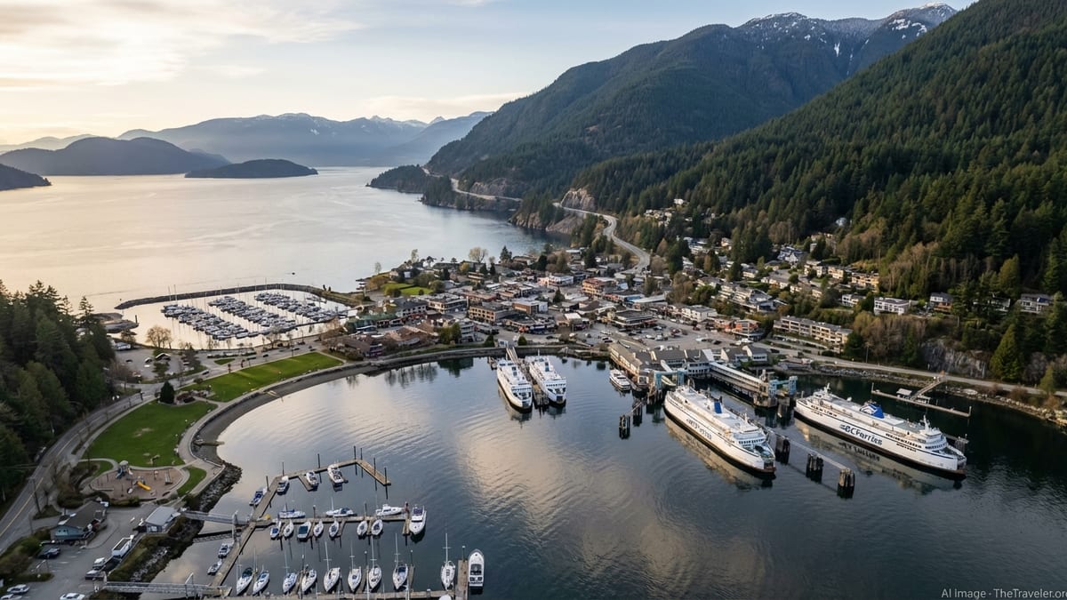
Set at the western tip of West Vancouver, Horseshoe Bay sits where the last stretch of urban highway meets a rugged coastline of islands, steep slopes and open water. The village curves around a natural horseshoe-shaped inlet, with marinas, a waterfront park and the BC Ferries terminal filling most of the shoreline. Above it all, Highway 1 and Highway 99 cling to the cliffs, making this compact community the western terminus of the Trans Canada Highway on the mainland and the southern end of the Sea to Sky Highway.
Despite its strategic role in British Columbia’s transport network, Horseshoe Bay feels surprisingly small scale. The core of the village is just a few blocks of low-rise buildings, local shops and casual restaurants framed by mountain ridges. Walk a few minutes in any direction and you are at the water’s edge, on a pier, or looking across Howe Sound to Bowen Island and the Sunshine Coast. The intimacy of the setting is part of its appeal: you are close to major routes, yet it feels like a harbour town tucked away from the city.
For Vancouver locals, Horseshoe Bay is a familiar reference point on weather reports and traffic updates, a place you pass through en route to the island or the mountains. For visitors, it can be the first real taste of coastal British Columbia beyond city limits. The ferry horns, the sight of white-hulled vessels sliding past mountain slopes, and the smell of salt water and fish and chips together send a signal that the trip has shifted from commute to journey.
That dual identity, both critical junction and leisure stop, is what makes Horseshoe Bay such an effective gateway. You can roll through in a rented car or on a bus and head straight for Whistler or Vancouver Island, or you can slow down, step out on the dock, and understand how this sheltered cove anchors an entire region of sea and sky.
A Working Ferry Hub With Scenic Crossings
Horseshoe Bay is one of the busiest ferry hubs in British Columbia, linking the Vancouver area with Vancouver Island, Bowen Island and the Sunshine Coast. Large roll-on, roll-off ships connect the village to Departure Bay in Nanaimo on Vancouver Island, carrying both vehicles and foot passengers across the Strait of Georgia on crossings that typically last around an hour and a half. Other vessels shuttle to Langdale on the Sunshine Coast and to Snug Cove on Bowen Island, opening up quiet coastal communities and resort areas that are not accessible by road alone.
The scale of operations is significant, with millions of passengers and vehicles moving through the terminal each year, but the experience remains distinctly scenic. As ferries pull away from the docks, they motor past marinas, fishing skiffs and pleasure craft before threading into Howe Sound and then wider waters. On clear days, travelers can see layers of blue and green mountains on both sides of the strait, along with the rocky outcrops and small islands that dot the channel into Nanaimo and Langdale. Even routine sailings often deliver views of seabirds, seals and the occasional porpoise.
Recent years have brought ongoing upgrades and construction at the Horseshoe Bay terminal, including essential infrastructure work and new booking systems for vehicle traffic. Travelers planning to drive on to ferries, particularly those heading to Departure Bay in Nanaimo, are increasingly encouraged or required to book and pay in advance, a measure meant to manage limited space and reduce congestion in and around the village as capacity is temporarily reduced. Foot passengers and cyclists, by contrast, generally retain more flexibility and can usually board without reserved tickets, though it is wise to check the latest advisories and seasonal schedules before departure.
For many visitors, the ferries themselves are part of the journey rather than simply a means of transport. Outdoor decks, onboard cafes and lounge seating invite travelers to treat the crossing as a short coastal cruise. Departing from a village that sits at the edge of both mountains and sea, every sailing from Horseshoe Bay reinforces the sense that Vancouver is only the beginning of British Columbia’s coastal landscape.
The Village: Cafes, Views and a Walkable Waterfront
Step away from the terminal and Horseshoe Bay quickly reveals a softer side. The village is compact and walkable, centered on a waterfront park with lawns, a playground and benches looking directly onto the bay. It is here that many drivers and passengers wait out their boarding time, stretching their legs under tall trees or wandering down to the public pier to watch ferries arrive and depart at close range. From the dock, you can see purple sea stars on pilings when the tide is low and spot seals surfacing between moored boats.
Just across from the park, small restaurants and cafes line the main streets, offering a mix of comfort food, local seafood and snacks tailored to travelers in transit. Fish and chips is a longstanding favourite, with several eateries serving generous portions to those keen to eat outdoors with a view of the harbour. Coffee shops cater to early-morning commuters and road trippers alike, while ice cream shops and bakeries give families simple options to keep children occupied between sailings.
Art galleries and gift shops add a cultural touch, often highlighting Indigenous artwork and West Coast themes. Local galleries in the village showcase carvings, jewelry and prints from regional artists, making Horseshoe Bay an accessible place to connect with coastal art without committing to a full-day museum visit. Browsing is easy to fit into even a short layover, and many travelers discover that their first keepsake from British Columbia comes not from downtown Vancouver but from this compact harbour town.
Because the village is surrounded by steep hillsides, viewpoints appear quickly as you gain even a bit of elevation. A short uphill walk along residential streets can reveal broader vistas across Howe Sound and back toward the city, especially on clear days. The interplay of ferries, marinas and mountain slopes means there are few bad angles for a photograph, and even a quick stroll from the terminal can produce images that encapsulate the coastal character of the region.
Whytecliff Park and the Nearby Shoreline
Just south of Horseshoe Bay, along a narrow coastal road, Whytecliff Park offers one of the best close-range vantage points on Howe Sound. It is a local favourite for tide pooling, short coastal walks and sunset views. The park’s rocky beach looks out onto small islands, the most distinctive of which is Whyte Islet, a knuckle of stone that can be reached on foot at low tide by scrambling over barnacle-covered rocks. When the water is high, the islet stands separate, backed by dense forest and distant mountain ranges.
Whytecliff Park is often described as one of the premier shore diving locations near Vancouver, thanks to its underwater walls and relatively accessible entry points. Even for non-divers, though, the appeal is immediate: exposed reefs, driftwood-strewn beaches and clear views across the mouth of Howe Sound toward the Sunshine Coast and Bowen Island. On calm days, the water takes on a deep green or turquoise tone that contrasts with the grey rock and dark evergreens. At almost any time of year, visitors might see seals hauled out on rocks offshore or swimming between anchored boats.
The atmosphere in the park feels more secluded than its proximity to the city might suggest. Walking paths wind through second-growth forest to small viewpoints and picnic tables, and the sounds of traffic are largely replaced by waves and seabirds. Metered parking and designated picnic areas make it practical for families, day trippers and anyone breaking up a longer drive. For travelers using Horseshoe Bay as the starting point of a Sea to Sky road trip, a short detour to Whytecliff Park can offer a first immersion in the coastal ecosystem before they head north into the mountains.
North of the village, the shoreline unfolds in a different way. As Highway 99 leaves Horseshoe Bay, it clings to the cliffs above Howe Sound, with pullouts and provincial parks such as Porteau Cove providing access to the water. The transition feels abrupt: one moment you are in a ferry village buying coffee, the next you are on a dramatic coastal highway where every turn reveals more open sea and steep forested slopes.
The Sea to Sky Highway: From Harbour to High Peaks
Horseshoe Bay is widely considered the official start of the Sea to Sky Highway, a celebrated section of Highway 99 that runs north along Howe Sound before climbing toward Squamish, Whistler and Pemberton. For many drivers, the village is the last chance to stock up on snacks, adjust plans and check weather conditions before tackling a route that is as spectacular as it is demanding. After leaving the bay, the road threads between rock faces and guardrails, with frequent glimpses of ferries, islands and white-capped peaks.
Northbound, some of the first notable stops include Porteau Cove Provincial Park, a small campground and day-use area that juts into Howe Sound, and viewpoints that look back toward Horseshoe Bay and the distant skyline of Metro Vancouver. The highway, which underwent extensive upgrades ahead of the 2010 Winter Olympics, varies between divided four-lane stretches and narrower segments with passing lanes. Even with these improvements, conditions can be challenging in winter or during heavy rain, and drivers are advised to follow seasonal tire requirements and watch for rapidly changing weather.
As travelers push beyond the coast toward Squamish and Whistler, the character of the landscape shifts from saltwater fjord to river valley and alpine peaks. Yet Horseshoe Bay remains the psychological beginning of the journey, the point where city driving ends and a true mountain road begins. Those who arrive in the village on a bus or as foot passengers on the ferry often transfer here to tour coaches or rental vehicles bound for the resorts and trailheads further north, underscoring the village’s role as a multi-modal gateway.
For visitors with flexible itineraries, it is worth building extra time into the day’s schedule to accommodate both the scenic stops along the Sea to Sky and potential traffic delays. Horseshoe Bay, with its food options, restrooms and open spaces, works well as a staging point. Whether you are planning a direct run to Whistler or a leisurely drive with multiple viewpoints and hikes, this harbour village marks the transition from metropolitan Vancouver to one of Canada’s iconic mountain corridors.
Getting to Horseshoe Bay from Vancouver
Reaching Horseshoe Bay from downtown Vancouver is straightforward. By car, the most direct route is via the Lions Gate Bridge and the Upper Levels Highway, following signs for Highway 1 and then Highway 99 westbound. In light traffic, the journey can take roughly half an hour, though rush hour, summer weekends and holiday periods often extend that time considerably. Parking options in Horseshoe Bay include pay lots near the ferry terminal and additional spaces dotted around the village, but capacity is limited, especially when ferry sailings coincide with peak travel seasons.
Travelers without a vehicle can rely on public transit. An express bus connects downtown Vancouver with Horseshoe Bay, running along key corridors and using highway lanes to reduce travel time. Buses are typically equipped with bike racks, and service tends to be frequent during the day, aligning loosely with ferry schedules. While this makes it possible to visit the village and connect to ferries without a car, it is essential to check current timetables in advance, as departure times and frequencies can change by season and day of the week.
Taxi and rideshare services also operate between Vancouver and Horseshoe Bay, though fares reflect the distance and traffic patterns. For small groups or those with luggage or ferry bookings at set times, a pre-arranged car service can provide predictability, particularly early in the morning or late at night when transit options may be reduced. Whichever mode of transport you choose, planning around the possibility of congestion on bridges and the Upper Levels Highway is prudent, since a short delay in the city can cascade into missed ferry sailings.
Travelers coming from Vancouver International Airport typically connect via downtown Vancouver or transfer to rental cars before heading to Horseshoe Bay. Allowing for airport processing, luggage collection and potential traffic, many visitors choose to overnight in the city and make the harbour village their first outing the following day, rather than attempting to rush from a flight directly to a scheduled ferry departure.
When to Visit and How to Make the Most of Your Time
Horseshoe Bay is a year-round destination, but the experience shifts noticeably with the seasons. Summer months tend to bring the warmest temperatures, the longest days and the most reliable views, making it the most popular time for ferry travel, Sea to Sky road trips and day visits to the village. This popularity also means busier sailings, tighter parking and more competition for restaurant tables and picnic spots. Advance reservations for vehicle travel and flexible timing for meals and fuel stops are wise during peak summer and long holiday weekends.
Spring and autumn can be excellent times to experience the bay with fewer crowds. In April and May, snow still caps the nearby mountains while cherry trees and coastal vegetation begin to bloom at sea level. September and October often deliver crisp days and calmer travel patterns after the height of summer. Weather, however, is more variable in these shoulder seasons, and visitors should be prepared for cool winds off the water, passing showers and shifting visibility on the highway north.
Winter brings a different mood. While Horseshoe Bay does not typically experience the heavy snowfalls found in the mountains above, it can see cold rain, gusty winds and fog. Ferries generally continue to operate, but schedules can be affected by severe storms or operational constraints, and the Sea to Sky Highway may require winter tires or chains depending on conditions and provincial regulations. For those en route to ski resorts, the village becomes a functional yet atmospheric pause between city and alpine, with the glow of terminal lights reflecting off dark water and low clouds.
Regardless of season, visitors can make the most of their time in Horseshoe Bay by blending practical tasks with simple pleasures. Arrive early for your ferry to allow time for a short walk along the waterfront, a coffee in the village or a quick detour to a nearby viewpoint. Keep an eye on current information from transportation providers regarding construction, booking requirements and any temporary changes in access or capacity, especially during ongoing terminal upgrades. Approached with a bit of planning, even a short layover can feel like a meaningful part of the journey rather than an anonymous wait in a staging lane.
The Takeaway
Horseshoe Bay occupies a rare position on the map and in the imagination of travelers leaving Vancouver. It is at once a small harbour village, a major ferry terminal and the southern gateway to a mountain highway that has become a destination in its own right. That combination gives the place an energy that blends anticipation, movement and coastal calm.
For some, the village is a brief pause on the way to Vancouver Island, Bowen Island, the Sunshine Coast or the ski slopes of Whistler. For others, it is a day trip from the city, a chance to sit by the water, admire the ferries and sample classic West Coast food in a setting that feels removed from urban life. In both cases, Horseshoe Bay helps define the transition between city and wild coast, between daily routine and the open-ended possibilities of a journey.
By understanding its geography, transport links, seasonal rhythms and nearby attractions, travelers can treat Horseshoe Bay as more than a line item on an itinerary. It becomes a scenic gateway, an introduction to the interplay of mountains and sea that characterizes so much of coastal British Columbia. Whether you arrive on a bus, in a car or on foot with your luggage in hand, this compact bay is where the story of the road ahead begins.
FAQ
Q1. How long does it take to get to Horseshoe Bay from downtown Vancouver?
In light traffic, the drive can take around 30 minutes, but congestion on bridges and the Upper Levels Highway can extend that time significantly, especially at peak hours.
Q2. Do I need a reservation for ferries leaving from Horseshoe Bay?
Vehicle travelers, particularly those sailing to Nanaimo’s Departure Bay, are strongly encouraged or sometimes required to book in advance, while foot passengers usually have more flexibility and can often travel without reservations.
Q3. Can I visit Horseshoe Bay without a car?
Yes, frequent express buses connect downtown Vancouver with Horseshoe Bay, and the village itself is compact and walkable, making it straightforward to explore on foot or connect to ferries as a foot passenger.
Q4. Is there parking available near the ferry terminal?
There are pay parking lots and street spaces near the terminal and around the village, but capacity is limited and lots can fill quickly during busy sailings and peak travel seasons.
Q5. What is there to do in Horseshoe Bay if I have a short layover?
With even an hour or two, you can stroll the waterfront park, walk out on the public pier, grab a meal or coffee in the village and browse local galleries or shops.
Q6. How close is Whytecliff Park to Horseshoe Bay?
Whytecliff Park is only a few minutes’ drive south of Horseshoe Bay, making it an easy side trip for tide pooling, coastal walks and views across Howe Sound.
Q7. When is the best time of year to visit Horseshoe Bay?
Summer offers the warmest weather and clearest views but also the biggest crowds, while spring and autumn provide a balance of manageable visitor numbers and often beautiful, if more changeable, conditions.
Q8. Is Horseshoe Bay a good starting point for the Sea to Sky Highway?
Yes, Horseshoe Bay is widely regarded as the southern gateway to the Sea to Sky Highway and works well as a place to refuel, pick up supplies and adjust plans before driving north.
Q9. Are there food and restroom facilities near the terminal?
Yes, the village has multiple restaurants, cafes and takeout options within a short walk of the terminal, along with public restrooms in the waterfront park and within the ferry facilities.
Q10. Can I see wildlife around Horseshoe Bay?
It is common to spot seals, seabirds and intertidal life such as sea stars around the docks and nearby shoreline, and with luck you may see porpoises or other marine animals from ferries or coastal viewpoints.