
Arkansas is known for its mountains, rivers and small towns, which makes exploring the state rewarding but sometimes logistically tricky. Distances can be longer than they appear on the map and public transportation is limited outside a few metro areas. With a little planning, though, getting around the Natural State can be straightforward and enjoyable, whether you are road tripping, relying on buses, or flying into regional hubs.
Understanding Distances and Travel Realities in Arkansas
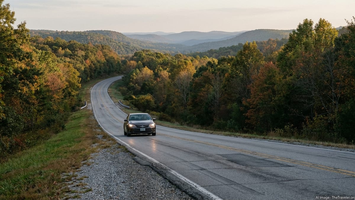
Arkansas looks compact on the map, but it is larger and more rural than many first-time visitors expect. Major destinations are spread out, and terrain varies from flat Delta farmland to the winding roads of the Ozark and Ouachita mountains. Driving times can be longer than expected, particularly on two-lane highways that curve through hills or pass through small communities.
The bulk of the state’s population and services are concentrated along the Interstate 40 corridor and in a few hubs such as Little Rock, Fort Smith and the Northwest Arkansas region around Fayetteville, Springdale, Rogers and Bentonville. Outside these areas, public transportation is limited and you may go long stretches without frequent gas stations or large rest areas. For most travelers, that means a personal vehicle or rental car is the most flexible way to move between cities and reach outdoor areas like state parks and lakes.
It also helps to plan your route in terms of travel time rather than distance. A drive of 150 miles on interstates may take just over two hours, while a similar distance on mountain highways can stretch into half a day once you factor in slower speeds, scenic stops and small-town traffic. During peak summer weekends or fall foliage season in the Ozarks, popular roads near lakes and parks can be busier and require extra time.
Seasonality matters too. Spring storms can bring heavy rain and occasional flooding in low-lying areas, and winter cold snaps can briefly turn bridges and higher mountain roads icy. While major highways are usually cleared quickly, minor roads and scenic routes may be slower to return to normal. Checking conditions with the Arkansas Department of Transportation before you set out, especially in winter or after heavy rain, is a prudent step.
Flying Into and Around Arkansas
Many visitors begin their Arkansas trip by air, and the state is served by a handful of commercial airports. Bill and Hillary Clinton National Airport in Little Rock is the primary gateway, offering the broadest range of flights and rental car options. In the northwest corner of the state, Northwest Arkansas National Airport near Bentonville and Fayetteville serves a growing business and leisure market and often provides convenient connections from larger hubs. Smaller commercial airports in Fort Smith and the Texarkana area give access to specific regions but with fewer routes and limited ground transport.
For most travelers, flying will be part of a combined strategy: arrive by air, then use a rental car for the bulk of local travel. Major airport car rental counters typically offer longer operating hours and broader fleets than small-town locations, which can be useful if your flight is delayed or you need a specialty vehicle such as an SUV. If you prefer not to drive immediately after landing, you can usually find taxis or rideshare services in Little Rock and Northwest Arkansas to reach a central hotel first, then pick up a car later.
Once in Arkansas, there are no regular commercial flights between cities in the way you might find in larger states. Charter flights and small regional services exist at some general aviation airports, but they are primarily aimed at business travelers or specific groups and tend to be costly compared with driving. For almost all visitors, flying is a way to arrive in the state, not a way to move between its main destinations.
If you are connecting onward to more remote areas, consider building in a buffer night in Little Rock or Northwest Arkansas. This reduces stress if flights are delayed and gives you the chance to stock up on supplies and orient yourself before heading into more rural parts of the state with fewer shopping or dining options.
Driving Arkansas: Highways, Scenic Byways and Rural Roads
Driving is the most practical and popular way to get around Arkansas, and the state’s road network is generally in good condition. Major interstates such as I-40, I-30, I-49 and I-55 carry most long-distance traffic, linking Little Rock with Memphis, Oklahoma City, Dallas and the Northwest Arkansas region. These routes are the fastest way to cover ground and usually offer frequent fuel, food and lodging options at interchanges.
The real charm of driving in Arkansas, however, is on its state highways and scenic byways. Routes that cross the Ozark and Ouachita mountains offer sweeping views, access to trailheads and lakes, and plenty of small-town character. Well-known scenic drives include sections of the Pig Trail Scenic Byway in northwest Arkansas and roads that wind through the Buffalo National River area. These routes can be narrow and curvy, so allow extra time, avoid aggressive passing and be prepared to encounter slow-moving farm equipment or deer, especially around dusk and dawn.
When planning a road trip, think about fuel and services. In populated corridors, gas stations and convenience stores are frequent, but in remote pockets of the Ozarks, southeast Delta or southwest timber country, you may drive many miles between open stations late at night. Topping off the tank regularly is wise if you will be exploring back roads or visiting state parks. Cell service can also be patchy in some rural or mountainous areas, so downloading offline maps in advance is helpful.
Driving in cities like Little Rock, Fayetteville or Fort Smith is comparatively easy. Rush hours are modest by big-city standards, and parking is generally manageable, particularly in downtown areas and around university districts. Some popular districts, such as the River Market in Little Rock or the entertainment and museum zones in Bentonville, can be busier on weekends and during events, but they still remain navigable with normal urban driving caution.
Renting a Car and Road-Trip Practicalities
For visitors arriving by air or from nearby states without their own vehicle, renting a car is usually the most convenient option. Rental counters are concentrated at major airports and in larger cities, with more limited availability in small towns. Booking ahead is strongly recommended, especially around major holidays, summer weekends and university-related events in Northwest Arkansas when demand can spike.
Standard sedans are adequate for most Arkansas travel, but an SUV or crossover can be more comfortable if you plan to drive on gravel roads, explore the mountains extensively or visit during winter when conditions can be more variable. Four-wheel-drive is generally not essential for paved roads, but higher ground clearance can provide extra confidence on rougher park access roads or forest routes that are open to passenger vehicles.
Insurance and coverage deserve attention as well. Check whether your personal auto policy or credit card offers rental coverage before purchasing supplementary packages. Given that some of Arkansas’s most interesting places are off the main highways, verify any restrictions on unpaved roads with the rental company. Keeping a paper copy of your rental agreement and emergency contacts in the glovebox is a small but practical precaution in case your phone battery dies or you lose signal.
For road-trippers in their own car, basic preparation can make travel safer and more relaxing. A recent service check, a spare tire in good condition and a simple emergency kit with water, snacks and a flashlight are all useful, especially if you are heading into sparsely populated regions. Arkansas summers can be hot and humid, so keeping plenty of drinking water in the vehicle is sensible if you expect to be hiking or spending time outdoors far from amenities.
Public Transit, Streetcars and Campus Buses
Arkansas has a patchwork of local transit systems rather than a single statewide network. The largest is Rock Region Metro, which operates fixed-route buses, microtransit services and a heritage-style streetcar in the Little Rock area. Its buses serve Little Rock, North Little Rock and several neighboring communities, connecting downtown districts, major shopping areas and the airport. For visitors staying in central Little Rock without a car, these services can be a practical way to reach key attractions and move around the urban core.
The Metro Streetcar operates over a short route linking downtown Little Rock and North Little Rock, including the River Market and cultural attractions along the Arkansas River. It runs two main lines that together provide frequent service most days, with slightly reduced operations on Sundays and holidays. While locals use it for short trips, many riders are visitors who appreciate the easy way it connects hotels, museums, restaurants and riverfront venues without having to manage parking.
In Northwest Arkansas, two primary public providers serve the region. Ozark Regional Transit operates bus routes covering communities such as Fayetteville, Springdale, Rogers and Bentonville, with a mix of fixed routes and demand-response services. The University of Arkansas’ Razorback Transit network focuses on Fayetteville and the university campus, providing frequent shuttles between residence halls, academic buildings, shopping centers and neighborhoods. Although designed for students, many routes are open to the public, making them useful if you are staying near the university or attending events there.
Transit options in other Arkansas cities are more limited, often focusing on demand-response or paratransit services for local residents. As a visitor, you are more likely to encounter structured transit networks in the Little Rock area and Northwest Arkansas. Before relying on buses as your primary mode of travel, it is sensible to review current routes and hours, since schedules can change and evening or weekend service is sometimes more limited.
Rideshares, Taxis and Shuttles
App-based rideshare services are established in the larger Arkansas metros and can be very useful for short hops, evenings out or airport transfers when you prefer not to drive. In Little Rock and North Little Rock, rideshares typically serve downtown hotels, the River Market, the airport and major shopping areas. In Northwest Arkansas, coverage tends to be strongest around Fayetteville, the university, Rogers, Bentonville and key event venues, with somewhat less availability in smaller surrounding communities.
Traditional taxi services still operate in the main cities and at the major airports, though fleets are generally modest compared with larger metropolitan areas. At peak times such as big sports events, concerts or festivals, both taxis and rideshares can see longer waits and higher prices. If you are attending a major event, planning your return trip in advance, whether by scheduling a ride ahead when possible or arranging a hotel within walking distance, can make the end of the evening much smoother.
Hotel and private shuttles round out the picture in select areas. Some hotels near the Little Rock airport and in Northwest Arkansas provide complimentary or paid shuttles for guests to and from terminals or nearby attractions. In resort communities or near certain lakes, outfitters and lodges may offer shuttle services to trailheads, river put-ins or marinas as part of guided activities. It is worth asking about these options when you book, particularly if you would prefer not to navigate unfamiliar mountain roads yourself.
Outside the major hubs, however, you should not assume that rideshares or taxis will be easily available at all hours. If you are heading to a remote cabin, rural wedding venue or lake house, it is safest to plan on having your own vehicle or coordinating transport in advance with your hosts.
Walking, Cycling and Outdoor-Friendly Transport
Within city centers and certain districts, walking can be a pleasant mode of transport. Downtown Little Rock, the River Market and adjacent riverfront parks are compact enough to explore on foot, particularly in the cooler months. In Northwest Arkansas, thriving downtowns in Fayetteville, Rogers and Bentonville have become more walkable in recent years, with sidewalks, crosswalks and trails connecting shops, restaurants, public art and museums.
Cycling has grown steadily in Arkansas, especially in the northwest, where an extensive trail network links communities and attractions. The Razorback Regional Greenway is a prominent example, stretching dozens of miles through several cities and passing near parks, shops and cultural sites. In these areas, renting a bike can be an enjoyable way to move between neighborhoods, particularly on weekends when traffic may be heavier on main roads.
Elsewhere in the state, cycling is more recreational than utilitarian for most visitors. Rural roads can be scenic and appealing for experienced cyclists, but shoulders are sometimes narrow and traffic speeds can be higher. If you plan to bike on public roads, high-visibility clothing, lights and an understanding of local traffic patterns are important. Weather is another factor: summer heat and humidity can be intense, so early morning or late afternoon rides are far more comfortable than midday outings.
Many state parks and recreation areas cater primarily to drivers but often include short walking paths, lakefront promenades and trailheads close to parking lots. Once you arrive by car, you may find that walking is the best way to experience waterfalls, overlooks or historic sites. Planning your transportation with this mix in mind can help you balance driving days with time on foot or on two wheels in the places that are best suited for it.
Traveling Between Regions: Buses, Trains and Long-Distance Options
Compared with some other parts of the United States, Arkansas has limited long-distance public transport within the state. There is intercity bus coverage along the main interstates and between major cities, but schedules may not be as frequent or flexible as in more densely populated regions. For budget travelers who do not drive, these services can still provide a workable backbone, especially for connections like Memphis to Little Rock or Little Rock to the Northwest Arkansas corridor, but they generally require more planning and patience.
Rail travel is possible but serves a narrower set of needs. Amtrak operates a route that calls at Little Rock, providing connections to cities outside Arkansas. Within the state, however, there is no network of frequent passenger trains linking different regions. For most itineraries, rail is a way to arrive or depart from Little Rock rather than to travel between Arkansas destinations.
Many visitors find that a hybrid approach works best. They may use an intercity bus or train to reach Little Rock from another state, then rent a car for a loop through Hot Springs, the Ouachita and Ozark mountains, and the Delta before returning the car and catching a train or bus onward. Others may fly into Northwest Arkansas, explore the region by car, then make their way by road or bus to Little Rock, treating the journey itself as part of the sightseeing.
If you plan to rely on long-distance buses or trains, flexibility is your friend. Building buffer time into your schedule, especially when coordinating with flights, helps account for delays or limited departure times. Keeping snacks, water and entertainment handy will also make longer rides through rural stretches more comfortable.
The Takeaway
Getting around Arkansas is less about racing between destinations and more about embracing the journey. The state’s mountains, rivers and small towns are spread out, and public transportation is strongest in just a few metro areas, so a car is often the most practical way to explore widely. With good planning, though, you can combine regional flights, local buses, streetcars, rideshares and even bikes to move comfortably through the Natural State.
For urban stays in Little Rock or Northwest Arkansas, local transit, rideshares and walkable districts make car-free days entirely feasible. For deeper explorations into state parks, historic towns and back roads, a reliable vehicle, extra time and an eye on weather and road conditions will serve you well. However you choose to travel, thinking ahead about distances, services and seasonal factors will help you spend more of your trip enjoying Arkansas and less of it worrying about logistics.
FAQ
Q1. Do I need a car to visit Arkansas as a tourist?
In many cases a car is the most practical way to explore Arkansas, especially if you plan to visit several regions, state parks or small towns. In Little Rock and Northwest Arkansas, you can rely more on local transit, rideshares and walking, but for rural areas and scenic drives, having your own vehicle or a rental offers far more flexibility.
Q2. Is there good public transportation in Arkansas?
Public transportation is strongest in the Little Rock area and Northwest Arkansas, where systems like Rock Region Metro, Ozark Regional Transit and Razorback Transit operate local routes. Outside these hubs, options are more limited and often focused on demand-response or paratransit services for residents, so visitors will typically find transit useful only in specific cities.
Q3. Can I get around Little Rock without renting a car?
Yes, if you stay in or near downtown you can often manage without a car. Rock Region Metro buses, the Metro Streetcar, rideshares, taxis and walkable riverfront districts make it possible to reach many hotels, restaurants and attractions. If you plan to explore farther-flung suburbs or state parks, however, renting a car or arranging a tour is advisable.
Q4. How do I travel between Little Rock and Northwest Arkansas?
Driving on the interstate system is the most flexible option and typically takes several hours, depending on traffic and exact start and end points. Intercity bus services can provide an alternative for those who do not wish to drive, but schedules may be limited. There is currently no frequent in-state commercial air shuttle between the two regions, so most travelers choose the highway.
Q5. Are rideshare services available throughout Arkansas?
Rideshare availability is best in larger metro areas such as Little Rock, Fayetteville, Rogers and Bentonville, and around airports and major event venues. In smaller towns and rural regions, coverage can be patchy or nonexistent, especially late at night. If you are heading somewhere remote, it is safer to assume you will need your own transport or prearranged rides.
Q6. What is driving like in the Ozark and Ouachita mountains?
Mountain driving in Arkansas can be beautiful but requires a relaxed pace. Roads are often curvy, with changes in elevation, occasional wildlife on the roadway and limited passing zones. In good weather and with daylight, most drivers find them manageable, but it is wise to avoid rushing, use pullouts when available, and be prepared for reduced visibility in fog or heavy rain.
Q7. Is cycling a realistic way to get around Arkansas?
Cycling is a great way to explore specific areas, particularly in Northwest Arkansas, where an extensive trail network connects multiple cities and attractions. However, outside these corridors, cycling is more of a recreational activity than a primary transport mode for visitors. Rural roads can be narrow and traffic speeds higher, so cycling between distant towns is best left to experienced riders.
Q8. Are there any passenger trains within Arkansas for getting between cities?
Passenger rail options within Arkansas are limited. Amtrak serves Little Rock on a longer interstate route, but there is no dense network of in-state trains linking major destinations. Most travelers use trains only to arrive in or depart from the state, then switch to cars, buses or other local transport for internal travel.
Q9. What is the best way to reach state parks and outdoor areas?
State parks and outdoor attractions are usually easiest to reach by car, whether your own or a rental. Some outfitters and lodges provide shuttles to trailheads, rivers or lakes as part of tours, and a few parks are close enough to towns to be accessed by bike or short drives from hotels. In general, though, expecting public transit or rideshares to reach remote trailheads will lead to frustration.
Q10. How should I plan for weather when driving around Arkansas?
Weather in Arkansas can change quickly, with hot, humid summers, stormy spring periods and occasional winter ice, especially on bridges and higher-elevation roads. Checking forecasts and highway conditions before long drives, allowing extra time in bad weather and carrying water and basic supplies in your vehicle will help keep your trip safe and comfortable.