
California is a state built for movement. Distances are long, landscapes change quickly, and how you choose to get around can shape your entire trip. Whether you are tracing the Pacific Coast by car, riding Amtrak between cities, or tapping into local buses and light rail, understanding your options is the key to traveling California comfortably, safely and with fewer surprises.
Understanding California’s Distances and Travel Reality
California stretches more than 750 miles from north to south, and most of its population clusters around a handful of major regions: the San Francisco Bay Area, Greater Los Angeles, San Diego, the Central Coast and the Central Valley. On a map, cities can look deceptively close. In practice, a journey from San Francisco to Los Angeles still typically takes six to seven hours by car in normal traffic, and driving from San Diego to Yosemite National Park can easily consume a full day. Planning how you will move between regions, and not just within them, is the first step in building a workable itinerary.
The state is still fundamentally car oriented, especially outside the big metropolitan centers. Rural areas, wine regions, national parks and many beach towns either have minimal public transportation or none at all after early evening. Even in major cities such as Los Angeles and San Diego, transit networks are expanding but do not yet offer the kind of all-day, go-anywhere convenience that many travelers may know from New York or European capitals. Visitors should arrive with realistic expectations and an understanding that combining modes is often the smartest approach.
At the same time, California is investing heavily in rail and cleaner urban transport. Recent state planning documents envision a more connected, lower-emissions system by mid century, with high-speed rail forming a backbone for intercity travel and regional trains, light rail and buses feeding into that network. While that future is still taking shape, travelers today can already take advantage of improved Amtrak corridors, metro extensions and electrified commuter lines in key corridors. Knowing which regions are transit friendly, and which still favor the steering wheel, will help you choose when to drive and when to ride.
Driving California: Highways, Rentals and Road Culture
For many visitors, renting a car remains the most flexible way to explore California. Major international airports such as Los Angeles, San Francisco, San Diego, Oakland and Sacramento have large on-site or nearby rental centers, and one-way bookings between big cities are usually straightforward, though they may carry additional fees. You will find all the major rental brands, as well as a growing number of car-share and peer-to-peer rental platforms in urban areas. Booking early is wise during peak summer months, long holiday weekends and school vacation periods, when demand and prices can spike.
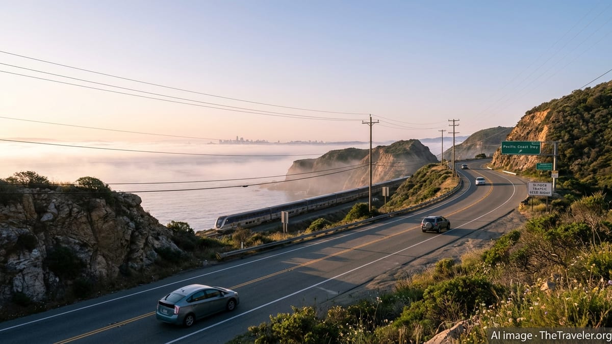
California’s main north–south spine is Interstate 5, a fast, inland freeway that links San Diego, Los Angeles, the Central Valley and Sacramento before continuing toward the Oregon border. It is the most direct driving route between Southern and Northern California but offers limited scenery. For a slower, more scenic journey, U.S. Highway 101 and State Route 1 trace the coast through Santa Barbara, San Luis Obispo and the Big Sur region when conditions allow. Coastal routes are often curvier and can close due to landslides or storms, so it is wise to check current road conditions close to your travel dates and allow generous time buffers.
California driving culture generally follows U.S. norms, but there are nuances. Freeways are multi-lane and can be congested at almost any time around Los Angeles and the Bay Area, with weekday peaks roughly aligning to morning and late afternoon commuting hours. Carpool or high-occupancy vehicle lanes are common and may be open to vehicles with two or more occupants, some clean-air vehicles or toll payers, depending on local rules. Speed limits are widely posted, enforcement is active, and penalties for impaired or distracted driving are strict. If you are unfamiliar with large multilane interchanges, budget time to drive conservatively and avoid late-night arrivals after long flights.
Driving Safely and Sustainably
Weather in California is generally mild along the coast but can vary significantly across the state. In winter, mountain passes heading toward Lake Tahoe, Yosemite and other Sierra Nevada destinations can see snow and chain controls, requiring tire chains or all-wheel drive in certain conditions. In summer, inland valleys can be extremely hot, with temperatures often well above 90 degrees Fahrenheit. Carry water, ensure your vehicle is in good condition and keep fuel levels above half a tank in remote stretches, particularly in desert areas such as Death Valley or along less-serviced routes.
Wildfire season, which can run from late spring through fall depending on the year, sometimes prompts road closures, evacuation orders or poor air quality in certain regions. Conditions shift year to year, so travelers should check state and local advisories, listen to local news and be prepared to change routes. If you encounter wildfire-related smoke or closures, follow official instructions, avoid stopping near active areas and stay flexible with your plans. In coastal regions, winter storms can bring heavy rain, localized flooding and landslides that affect coastal highways, especially in fragile sections of Big Sur.
California also offers many ways to reduce the environmental impact of driving. Hybrid and electric rentals are increasingly available, especially around major airports and cities. The state has one of the densest networks of public EV chargers in the United States, and more hotels, visitor centers and attractions now provide charging on site. Choosing a smaller vehicle, combining day trips to reduce backtracking and using park-and-ride facilities to connect to local transit all help lower emissions and ease congestion. Where possible, consider leaving the car parked for city days and opting for trains, buses or walking tours to experience neighborhoods more intimately.
Intercity Trains and Buses: Connecting California’s Regions
California’s main intercity rail services are operated in partnership with Amtrak, linking major cities and many mid-size destinations. The Pacific Surfliner line runs along the Southern California coast between San Luis Obispo, the Los Angeles area and San Diego, offering a scenic alternative to driving on some of the state’s busiest highways. In the north, the Capitol Corridor connects the Sacramento region with the East Bay and San Jose, while the San Joaquins route links the Bay Area and Sacramento to the Central Valley, with coordinated bus connections reaching as far as Los Angeles and San Diego.
These routes generally offer reserved seating, space for luggage, and in many cases Wi-Fi and café cars, making them a comfortable option for travelers who prefer to avoid airports or long freeway drives. Schedules can change seasonally, and service frequencies vary by route and day of the week, so checking current timetables and booking in advance is important. Rail travel times often compete well with driving on heavily congested corridors, though travelers should still build in a cushion for transfers and last-mile connections within cities.
California’s long-planned high-speed rail project, intended to connect the San Francisco Bay Area and Los Angeles through the Central Valley, remains under construction. Recent state updates emphasize that initial segments in the Central Valley are progressing, with infrastructure and track installation slated to advance over the next few years. For now, there is no high-speed passenger service available to travelers, but the project is beginning to influence station planning and rail connections in cities such as Merced, Fresno and Bakersfield. Visitors should understand that any mention of bullet trains in California refers to future plans rather than current travel options.
Intercity buses fill many of the gaps where rail does not yet reach. Several national and regional bus companies operate routes between California cities and neighboring states, from basic no-frills coaches to more premium services with extra legroom. Buses typically depart from downtown transit hubs or shared terminals, and they can be effective for travelers on tighter budgets, or for reaching destinations such as Palm Springs, Monterey, Santa Barbara and smaller Central Valley towns. As with rail, schedules and service levels can shift in response to demand, holidays and weather disruptions, so reconfirm departures closer to your travel date.
City Transit: Los Angeles, San Diego and the Bay Area
Public transportation within California’s major metros has improved in recent years, but quality and coverage vary by region and neighborhood. In the Los Angeles area, the regional network group brands much of its service under a single system name for rail and bus lines that reach across the county. New light rail and subway extensions have connected downtown with neighborhoods such as Koreatown, Santa Monica, the Arts District and parts of the San Fernando Valley, making it more feasible to visit select areas without a car. Still, many popular attractions in the Hollywood Hills, Malibu, Orange County and inland suburbs remain difficult to reach solely by transit.
San Diego offers an efficient light rail network known locally as the trolley, along with a bus system that covers much of the urbanized area. The trolley links downtown with Old Town, the border at San Ysidro, Mission Valley, La Mesa and University City, serving major destinations such as the convention center and stadium district. For coastal communities such as La Jolla, Del Mar and Encinitas, local and regional buses and the Coaster commuter rail fill in the gaps, though service may thin out at night and on weekends. Visitors staying downtown or in Old Town can often reach key attractions like Balboa Park and the beaches using a combination of trolley, buses and rideshare.
The San Francisco Bay Area has the state’s most complex mix of transit operators. A regional rapid transit system provides rail service between San Francisco, Oakland, Berkeley and several surrounding counties, including direct airport connections to San Francisco International and Oakland International. Caltrain, a separate commuter rail line, runs along the Peninsula between San Francisco and San Jose, serving Silicon Valley communities and linking with local bus and light rail networks. Numerous municipal and regional bus systems, plus ferries crisscrossing the bay, add further options. Visitors can often navigate central San Francisco, Oakland and Berkeley comfortably without a car, but venturing into smaller suburbs may still require driving or rideshare.
Tickets, Passes and Practical Transit Tips
Because California’s transit systems grew region by region, ticketing can feel fragmented to newcomers. Many urban networks now rely on reloadable smart cards or mobile apps for fares, often with daily or monthly caps that automatically limit how much you pay in a given period. In the Bay Area, for example, a single card or app is accepted by most agencies, including regional rail and many local buses and ferries. In Southern California, a number of operators have adopted compatible payment systems or mobile ticketing, but coverage is not yet universal, and paper tickets or cash fares are still common on some local buses.
For intercity trains and buses, advance reservations are standard and often necessary, especially on weekends, holidays and major event days. Fares tend to rise as departure dates approach on popular routes, and capacity-controlled promotional fares are usually limited. If your itinerary is flexible, traveling midweek or outside peak commute times can result in quieter trains and lower prices. Seat reservations and specific coach assignments depend on the operator and route, so read the booking details carefully before you travel.
Travelers unfamiliar with American transit systems should pay attention to safety basics. Most stations and vehicles are patrolled and equipped with security cameras, but petty theft can occur, particularly in crowded hubs and late at night. Keep bags close, avoid displaying valuables, and stay aware of your surroundings. If a station feels deserted or uncomfortable, wait near other passengers or staff, and consider changing cars to be closer to the conductor or driver. At night, rideshare services can be a practical complement to transit, especially for the final leg from a station to your accommodation.
Accessibility is improving but not uniform. Major urban rail systems are largely step free between street and platform or train, but older stations sometimes rely on a single elevator that can be out of service. Bus fleets increasingly feature low-floor designs, ramps and priority seating, and intercity operators are required to provide accessible vehicles with advance notice. Travelers with mobility, hearing or vision needs should review accessibility information on individual transit agency sites and build extra time into transfers and station navigation.
Exploring Without a Car: Walkable Districts and Scenic Rail
Despite California’s reputation as a car state, there are pockets where visitors can enjoy a largely car-free experience. Central San Francisco, including neighborhoods such as Union Square, Chinatown, North Beach and the Embarcadero, is compact and well served by buses, streetcars and light rail. The historic cable cars, though often crowded and tourist focused, add a scenic way to climb the city’s hills. Oakland’s downtown and waterfront districts, as well as central Berkeley, are also walkable and directly connected by regional rail.
In Southern California, staying in areas that combine accommodation, dining and attractions within a smaller radius can reduce your need to drive. Santa Monica offers a walkable downtown and beach area connected by light rail to central Los Angeles. Certain neighborhoods in central and downtown Los Angeles now mix residential, cultural and dining venues within easy reach of metro lines, although you may still rely on rideshare or occasional car rentals for outlying sights. In San Diego, the Gaslamp Quarter, Little Italy and Old Town function well for visitors who prefer to walk and use the trolley and buses for longer hops.
For travelers who enjoy the journey as much as the destination, California’s scenic train routes provide another way to see the state. The Pacific Surfliner’s stretch between Los Angeles and San Diego runs close to the shoreline for long segments, with broad views of beaches and coastal bluffs from the upper deck. North of San Luis Obispo, trains climb through rolling ranchland and oak-studded hills. Farther north and inland, the San Joaquins corridor passes through fertile farmland and small Central Valley communities, offering a different, more agricultural perspective on the state.
The Takeaway
Getting around California is ultimately about choosing the right tool for each part of your journey. A rental car remains the most practical way to access national parks, wine regions and many smaller coastal towns, but city centers such as San Francisco and parts of Los Angeles and San Diego can be explored effectively by transit, walking and rideshare. Intercity trains and buses give travelers options beyond the freeway, particularly along key corridors where rail service is frequent and reasonably reliable.
As California continues to invest in rail and cleaner transport, visitors will gradually see more choices, from electrified commuter lines to expanded metro systems. For now, a flexible, mixed strategy serves most travelers best: drive when you need to, ride when it is efficient and scenic, and do not underestimate the pleasure of simply walking through California’s varied neighborhoods and landscapes. With thoughtful planning, even long distances and complex city layouts can become part of the adventure rather than an obstacle.
FAQ
Q1. Do I need a car to visit California?
Many visitors find a car very useful, especially for national parks, wine regions and smaller coastal towns, but it is possible to rely on trains, buses and rideshare in major cities and along key intercity corridors.
Q2. Is driving in Los Angeles as difficult as people say?
Traffic in Los Angeles can be heavy and unpredictable, but if you avoid peak commute hours when possible, use navigation apps and stay patient, most visitors adjust quickly to local driving conditions.
Q3. Can I travel between San Francisco and Los Angeles without flying?
Yes, you can travel between San Francisco and Los Angeles by a combination of Amtrak trains and buses or by long-distance coach; the journey usually takes most of a day.
Q4. How reliable is public transportation in California’s big cities?
Reliability varies by region and line, but core urban rail services in the Bay Area, Los Angeles and San Diego generally run frequently during the day, with occasional disruptions and less frequent late-night service.
Q5. Are there transit passes I can use across multiple systems?
Some regions, particularly the Bay Area, offer smart cards or mobile apps that work across many local agencies, but there is no single pass that covers all of California’s transit networks.
Q6. What is the best way to get from Los Angeles to San Diego?
Many travelers either drive along the interstate or coastal highway, or take the Pacific Surfliner train, which offers a scenic ride and avoids freeway traffic on busy days.
Q7. Is California’s high-speed rail running yet?
No, high-speed rail in California is still under construction, with initial segments in the Central Valley progressing; there is currently no bullet train service available to passengers.
Q8. How can I travel more sustainably around California?
Choosing trains and buses where practical, renting hybrid or electric vehicles, staying in walkable neighborhoods and combining errands or day trips all help reduce your travel footprint.
Q9. Is public transit safe for solo travelers and families?
Most public transit in California is safe when you stay aware of your surroundings, keep belongings secure and avoid isolated areas late at night; many families use it comfortably during the day.
Q10. Do I need to reserve tickets in advance for trains and intercity buses?
Advance reservations are strongly recommended for most intercity trains and buses, especially on weekends, holidays and popular routes, to secure seats and better fares.