
Lake Huron does not reveal its character all at once. Its coastline shifts from sandy Michigan beaches and farm-dotted bluffs to Ontario’s rocky shield country and quiet harbor towns. The best way to understand that variety is behind the wheel. With well-signed circle tours, shoreline highways, and quiet backroads, you can build anything from a leisurely weekend drive to a full loop of the lake. This guide explains how to get around Lake Huron by car, where the most scenic routes run, and how to plan them safely.
Understanding the Lake Huron Driving Landscape
Lake Huron is shared between the U.S. state of Michigan and the Canadian province of Ontario, and its road network reflects that binational layout. On the American side, the core shoreline routes are Michigan’s M 25 in the Thumb region along lower Lake Huron and Saginaw Bay, and US 23 along the so called Sunrise Coast from Standish toward Mackinaw City. These tie into the Lake Huron Circle Tour, a scenic touring route created in the late 1980s as part of the broader Great Lakes Circle Tour system to help drivers follow the shore as closely as practical on existing highways.
In Ontario, the character shifts to longer distances between towns and more pronounced wilderness stretches. Provincial highways such as Highway 21 along the Lake Huron shore of southwestern Ontario, Highway 6 through the Bruce Peninsula and Manitoulin Island corridor, and Highway 17 north of Sault Ste. Marie link beaches, harbors, and rockier country. Some stretches of the former official Lake Huron Circle Tour signage in Ontario are now incomplete, so drivers rely more on good maps and GPS than on special markers.
Most visitors focus on one arc of the lake at a time. A popular approach is to drive a partial loop, such as Port Huron to Mackinaw City via the Michigan shoreline, or Sarnia to Tobermory in Ontario, then return inland. Ambitious travelers sometimes complete a full Lake Huron loop, starting at one of the international crossings, following shoreline highways around both countries, and linking Ontario’s Manitoulin Island to the Bruce Peninsula by ferry. Because the driving distances are significant and weather on the Great Lakes can change quickly, thoughtful planning is as important as picking a scenic road.
While dedicated scenic designations such as the Lake Huron Circle Tour and several Pure Michigan Byways highlight certain stretches, it is worth remembering that they rely entirely on standard public roads. You will be sharing narrow shoreline curves with local traffic, farm equipment, and occasionally heavy trucks. Understanding the basic geography and how border crossings, ferries, and seasons affect your options will make your Lake Huron trip smoother and safer.
Driving the Michigan Shore: M 25, the Thumb, and US 23
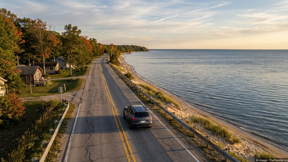
On the U.S. side, one of the classic Lake Huron drives follows Michigan’s M 25 from the Blue Water Bridge area at Port Huron through the Thumb region to Bay City. This roughly 150 mile corridor hugs the coastline, passing resort towns such as Lexington, Harbor Beach, Port Austin, Caseville, and small working communities along Saginaw Bay. Travelers meet beaches, lighthouses, roadside parks, and modest lake bluffs instead of dramatic cliffs, and that easygoing character is part of its appeal.
North and west of Bay City, the Lake Huron Circle Tour leaves M 25 and takes M 13 for a short distance before joining US 23 near Standish. From there, US 23 becomes the main shoreline route, threading through places such as Tawas City, Oscoda, Alpena, Rogers City, and Cheboygan. This segment is often marketed as the Sunrise Coast because the sun rises directly over Lake Huron. Here you find low traffic volumes outside summer weekends, quiet state parks, and occasional detours inland through state forest and farm country when the road cannot cling to the immediate shoreline.
Because both M 25 and US 23 serve small towns and rural areas, the driving pace is inherently slower than on the freeways feeding into Port Huron, Saginaw, or I 75. Posted speeds regularly drop as you approach a harbor town or river crossing, and some stretches have only two narrow lanes with soft shoulders. Plan extra time for agricultural vehicles and frequent scenic stops. Travelers should also anticipate that gas stations and restaurants become more widely spaced north of Standish, especially during shoulder seasons, so topping off the tank and carrying basic snacks and water is wise.
In terms of scenery, the M 25 Thumb arc emphasizes sand beaches, boardwalks, and lighthouse views, particularly near Port Austin and Harbor Beach. Along US 23, the shoreline gains more variety: dune backed beaches near Tawas Point, forest backed curves around Alcona County, and views into shipwreck rich Thunder Bay near Alpena. Short inland diversions link to additional attractions, including the River Road National Scenic Byway, which leaves Lake Huron and follows the Au Sable River westward through the Huron National Forest, offering overlooks, trailheads, and historical sites.
Upper Peninsula and North Huron: Byways and Island Detours
At the northern end of the lower Michigan shoreline, US 23 meets I 75 at Mackinaw City, and the Lake Huron Circle Tour crosses the Mackinac Bridge to St. Ignace. From here, drivers can choose whether to continue following the Lake Huron side into the eastern Upper Peninsula or pause for side trips to islands and parks. The Upper Peninsula portion of the lake is less heavily developed than the lower Michigan shore. Forest, wetlands, and rocky bays dominate, broken by small communities and harbor towns.
East of St. Ignace, state highway M 134 is a key scenic corridor along the North Huron shore. It runs from an interchange on I 75 east toward Hessel, Cedarville, and De Tour Village, with water views, stretches along the Les Cheneaux Islands channels, and short access roads to state parks and public launches. The majority of this mainland stretch also forms part of the Lake Huron Circle Tour and has been designated a Pure Michigan Byway, known as the M 134 North Huron Byway, in recognition of its scenic and recreational value.
Beyond De Tour Village, a ferry across the De Tour Passage carries vehicles, cyclists, and pedestrians to Drummond Island. Here, M 134 continues on the island, looping along portions of the shoreline before ending near a crossroads south of the main settlement. Drummond Island is known for off road routes, quiet coves, and low key cottage development rather than drive through attractions, so travelers should arrive with a clear sense of what services exist and where they will stay or camp.
Another notable detour is Mackinac Island, technically within Lake Huron where it meets Lake Michigan. Vehicles are not allowed on the island, and access is by passenger ferry from Mackinaw City or St. Ignace. Once there, a narrow paved state highway, M 185, encircles the island along the shore, used only by pedestrians, cyclists, and horse drawn transport. While not a driving route in the literal sense, Mackinac Island often features in Lake Huron touring plans as a car free interlude. Travelers should plan secure parking on the mainland and factor ferry schedules and weather into their timing.
The Ontario Shore: Highway 21, Bruce Peninsula, and Manitoulin Island
On Ontario’s side of Lake Huron, the main shoreline corridor in the south is Highway 21, running between the Sarnia area and Owen Sound region through a chain of lakefront towns and agricultural land. Communities such as Grand Bend, Bayfield, Goderich, Kincardine, and Southampton mix beaches, marinas, and compact historic downtowns. The road often runs close enough to the lake for glimpses of water between cottages and fields, then ducks inland before returning to the shore as it approaches another river mouth or harbor.
Farther north, Highway 6 becomes the spine of one of Lake Huron’s most distinctive drives, across the Bruce Peninsula. From the base of the peninsula, the road runs through Lion’s Head and other small communities before ending at Tobermory. This area is valued for its clear turquoise water, rocky coves, and access to national parkland and offshore islands. In peak summer the road can be busy with recreational traffic, and parking near trailheads or harbor areas fills quickly, so an early start and flexible expectations help.
Highway 6 continues across the lake itself via a seasonal vehicle ferry that links Tobermory to South Baymouth on Manitoulin Island. The crossing gives drivers a break from the wheel and a broader perspective on Lake Huron’s scale. Once on Manitoulin Island, local highways and county roads connect communities such as Manitowaning, Little Current, and Gore Bay. This is one of the quieter segments of a Lake Huron touring plan, with small towns, First Nations communities, and low key outdoor recreation rather than large resorts.
From Manitoulin, travelers usually reconnect with the mainland near Little Current, where a bridge links the island to Highway 6 again, then continue north or west toward Espanola and Highway 17. While the former Lake Huron Circle Tour signs in this region are inconsistent today, the basic routing remains logical: follow shoreline oriented highways toward either Sault Ste. Marie for a return to Michigan or toward Sudbury and inland Ontario if you are combining Lake Huron with other Great Lakes or northern itineraries.
Planning a Lake Huron Circle Tour or Sectional Road Trip
Deciding whether to drive a full Lake Huron loop or focus on one shoreline section is largely a question of time and interest. A complete circuit, routed through both Michigan and Ontario, often runs to well over one thousand miles by the time you add side roads, island detours, and inland connectors. Drivers who want to travel at a relaxed pace with time for hikes, museums, and town walks typically budget at least eight to ten days for a full loop. Those with four to six days often concentrate on the Michigan shoreline or a combination of the Bruce Peninsula and Manitoulin Island instead.
Entry to Canada and back to the United States requires valid travel documents for everyone in the vehicle. The most common crossings related to Lake Huron trips are the Blue Water Bridge between Port Huron and Sarnia, and the Sault Ste. Marie International Bridge between Michigan and Ontario. Wait times vary by season and even time of day, so checking current conditions before you approach can help you adjust fuel and rest stops. Travelers should also be aware of differing speed limits, fuel prices, and road signage conventions on each side of the border.
For a structured itinerary, many drivers still loosely follow the Lake Huron Circle Tour concept even if specific signs are incomplete in places. This usually means starting at one of the border bridges, tracing the shoreline highways in a clockwise or counterclockwise direction, and using ferries such as the Tobermory to Manitoulin link or the Drummond Island service where they fit your plan. Others prefer hub and spoke trips, basing in a town such as Alpena, Bay City, Goderich, or Tobermory and exploring in day trip arcs instead of changing lodgings every night.
Because Lake Huron’s weather and water levels can shift between years and even weeks, flexibility pays off. Road construction, shoreline erosion work, or high water may temporarily close a park access road or small bridge. Having alternative scenic drives mapped out inland, such as forest routes and river byways near the Au Sable or in Ontario’s interior, ensures that a single closure does not derail your plans.
Seasonal Conditions, Safety, and Practical Driving Tips
Seasonality shapes how you experience Lake Huron’s roads. Summer brings the best swimming and boating conditions but also the heaviest traffic in resort towns, busiest border crossings, and highest room rates. Shoulder seasons in late spring and early autumn often offer clear views, cool temperatures, fall color in hardwood stands, and fewer crowds, though some smaller attractions and seasonal restaurants may have limited hours or be closed.
Winter transforms much of the shoreline into a quieter landscape of ice, snow, and frozen harbors. Many roads remain open and are regularly plowed, but conditions can deteriorate quickly during lake effect snow events or freezing rain. If you are considering off peak travel, especially north of Bay City or on Ontario’s more remote sections, plan for winter tires, emergency supplies, and extra flexibility in case roads close temporarily. Ferries are seasonal in most cases, so island detours that work in July may be impossible in January.
Basic driving safety is straightforward but important on Lake Huron routes. Wildlife crossings are common at dawn and dusk, particularly deer along forested stretches and near agricultural land. Many shoreline curves lack generous shoulders, and there can be sudden transitions between open rural segments and small towns with lowered speed limits, crosswalks, and angled parking. Avoid driving long unfamiliar stretches after dark if you can, especially where roadside lighting is minimal and navigation relies heavily on visual cues.
Service availability also varies. Urban hubs such as Port Huron, Saginaw, Sarnia, and Sault Ste. Marie have full service fuel, food, and lodging options. Smaller communities may have only one gas station and limited evening hours, particularly outside main tourist seasons. Keeping your fuel tank above the halfway mark, carrying a paper map as backup to electronic navigation, and checking ferry and border schedules in advance will all make your Lake Huron road trip smoother.
The Takeaway
Getting around Lake Huron by car is less about conquering miles and more about settling into the rhythms of shoreline travel. On the Michigan side, M 25 and US 23 provide a chain of beachtown stops, lighthouses, and gentle curves. North of the Mackinac Bridge, quieter byways such as M 134 and the roads on Drummond Island add a wilder flavor. Across in Ontario, Highway 21 ties together farm country and harbor towns, while Highway 6 and the ferry to Manitoulin Island create one of the most distinctive Great Lakes driving experiences.
Whether you complete the entire circle or focus on one arc, thoughtful planning pays off. Understanding how the Lake Huron Circle Tour aligns with existing highways, how border crossings and ferries fit into your route, and how seasons affect everything from traffic volumes to visibility will help you match your itinerary to your comfort level behind the wheel. Give yourself enough time for serendipitous stops, and remember that some of Lake Huron’s best moments come when you pull off the main road and simply watch the light shift over the water.
With realistic expectations, a reliable vehicle, and a flexible schedule, Lake Huron’s roads open up a network of coastal landscapes, small towns, and island detours that rarely feel crowded once you leave the main summer weekends behind. The practical routes and tips in this guide can serve as a framework, but the real joy comes from tailoring them to your own pace, whether that means a weekend in the Thumb, a leisurely Ontario shore vacation, or a dedicated multi week loop around the whole lake.
FAQ
Q1. How long does it take to drive all the way around Lake Huron?
Most travelers who complete a full loop around Lake Huron by car allow at least eight to ten days so they can drive safely, cross the border, use ferries, and still have time for walks, museums, and shoreline stops.
Q2. Do I need a special permit to follow the Lake Huron Circle Tour?
You do not need a permit to follow the Lake Huron Circle Tour. It is a suggested routing using existing public highways, but you must meet normal border, licensing, and insurance requirements.
Q3. What documents are required to cross between Michigan and Ontario by car?
Drivers and passengers generally need a valid passport or other approved travel document, such as certain enhanced driver’s licenses or trusted traveler cards, to cross between the United States and Canada by land.
Q4. When is the best time of year to drive Lake Huron’s scenic routes?
Late spring through early autumn offers the most reliable weather, open attractions, and ferry service, with autumn adding fall foliage and somewhat lighter crowds compared with midsummer.
Q5. Are the Lake Huron ferries for vehicles or just passengers?
Key ferries connected to Lake Huron touring, such as the Tobermory to Manitoulin Island service and the De Tour Village to Drummond Island link, are designed to carry vehicles as well as foot passengers, subject to capacity and seasonal schedules.
Q6. Is it possible to do a Lake Huron road trip without a car?
Public transport around Lake Huron’s shoreline is limited, so most visitors rely on a private vehicle. However, certain segments, such as the Bruce Peninsula or parts of the Michigan Sunrise Coast, can be explored by combining regional buses, taxis, and cycling.
Q7. How challenging are the roads for inexperienced drivers?
Most Lake Huron routes are standard two lane highways, but they include narrow shoulders, wildlife crossings, and frequent speed changes near towns, so inexperienced drivers should plan shorter daily distances and avoid night driving where possible.
Q8. Can I find electric vehicle charging stations along Lake Huron?
Charging infrastructure is improving, especially near larger cities and popular tourist towns, but it is still sparse in remote areas, so electric vehicle drivers should plan routes carefully and verify current charging options in advance.
Q9. Are there toll roads involved in a Lake Huron driving trip?
The main tolls you are likely to encounter are on international bridges such as the Blue Water Bridge and the Sault Ste. Marie bridge, while most shoreline highways themselves are toll free.
Q10. Is it safe to drive around Lake Huron in winter?
Winter driving can be safe with proper preparation, including winter tires, emergency supplies, and flexible timing, but lake effect snow and ice can make conditions hazardous, so some travelers prefer to restrict longer shoreline trips to milder seasons.