
Driving around Lake Superior is one of North America’s great road trips, a journey that combines big water, boreal forest, small towns, and quiet stretches of highway where the lake seems to fill the entire horizon. Whether you are attempting the full Circle Tour or focusing on one shoreline at a time, understanding the key routes, driving conditions, and scenic highlights will help you build a trip that is both memorable and manageable.
Understanding the Lake Superior Circle Tour
The Lake Superior Circle Tour is a designated driving route that loops around the entire lake through Minnesota, Wisconsin, Michigan, and Ontario. It uses existing highways rather than a single special road, but the Circle Tour signs help guide drivers along the shoreline where possible. Completing the full loop typically requires at least four to seven days of flexible driving, with extra time if you plan to hike, explore coastal towns, or detour inland.
The route runs counterclockwise or clockwise depending on preference, with many travelers starting in Duluth or Thunder Bay because these cities have the best flight connections, lodging, and rental car options. From Duluth, for example, you can head northeast along Minnesota’s North Shore or southwest through Wisconsin and into Michigan’s Upper Peninsula before crossing into Canada and closing the loop. The sequence does not matter as much as understanding where the scenic stretches and longer, quieter segments are.
Because the Circle Tour crosses the United States and Canada, you will need valid passports or other accepted documents for the border crossings. Waiting times at border posts can vary seasonally and by day of the week, so it is wise to build buffer time into your schedule. You should also remember that the tour covers remote sections, particularly in northern Ontario and stretches of the Upper Peninsula, where fuel, food, and lodging may be widely spaced.
Many travelers choose to drive only part of the Circle Tour, focusing on one or two sections such as Minnesota’s cliff-lined North Shore or the rugged Ontario coast between Sault Ste. Marie and Terrace Bay. There is no requirement to complete the full loop. Planning your route segment by segment will help you link scenic highways into a driving plan that matches your time, comfort level, and interests.
Minnesota’s North Shore: Highway 61 and Beyond
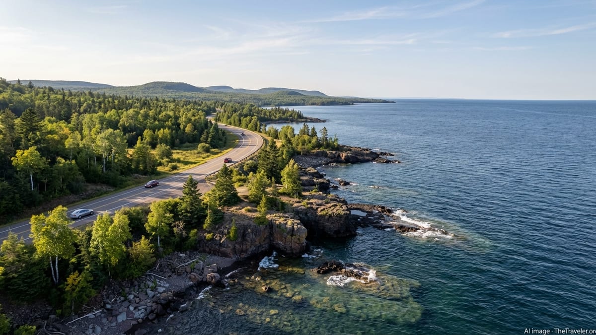
Minnesota’s side of Lake Superior is dominated by Highway 61, a 150 mile corridor between Duluth and the Canadian border that is recognized as a scenic byway. The North Shore Scenic Drive follows this route, at times closely hugging the lake and at others climbing above it for broader views. You will pass iconic lighthouses, river gorges, and a sequence of state parks that make this one of the most celebrated lakefront drives in the region.
Leaving Duluth, many travelers opt for the slower, lakeside segment known as Scenic 61, which parallels the main highway for about 20 miles and offers frequent pulls offs where you can walk down to the cobble beaches. Further northeast, Highway 61 becomes a mix of two lane and divided highway, with numerous signed wayside rests and turnouts for waterfall access, beach walks, and viewpoints. Popular stops include Gooseberry Falls, Split Rock Lighthouse, Tettegouche, Temperance River, Cascade River, and Grand Marais, each reached directly from the main road by short access lanes.
Beyond the shoreline, the Gunflint Trail extends inland from Grand Marais into forest and lake country, eventually reaching the edge of the Boundary Waters Canoe Area Wilderness. This 50 plus mile paved road is officially designated as a National Scenic Byway and provides a completely different driving experience, with twisting forest curves, abundant wildlife, and frequent side roads to lodges and canoe outfitters. It does not circle back to the highway, so you will return the same way you came, but the combination of Highway 61 and the Gunflint Trail makes for a rewarding side trip.
Driving conditions on Minnesota’s North Shore vary with the seasons. Summer brings the heaviest traffic, especially on weekends and holiday periods, while autumn is popular for fall foliage. Winter driving can be beautiful but challenging, with snow, ice, and sudden changes in visibility along the lakeshore. If you plan to visit outside summer, check road reports regularly, build in extra time, and be prepared for rapidly shifting weather coming off the lake.
Wisconsin’s South Shore: Quiet Highways and Small Towns
On the southern arc of Lake Superior, Wisconsin’s shoreline offers a quieter, more rural driving experience. The primary route follows U.S. Highway 2 and State Highway 13 between Superior and Hurley, linking working ports, small towns, and long sand beaches. Compared with the dramatic cliffs of the North Shore, this coastline feels more subtle, with gently curving bays, marshes, and low dunes.
From Superior, many drivers take Highway 13 toward the Bayfield Peninsula. This section winds through farmland and forest before reaching the harbor town of Bayfield, gateway to the Apostle Islands. Short side roads lead down to public beaches and marinas, and in summer you will share the roads with cyclists and local traffic headed to orchards and berry farms. Continuing east, Highway 13 hugs the shoreline more closely toward towns like Washburn and Ashland before rejoining U.S. 2.
U.S. 2 carries you farther east across northern Wisconsin, usually a few miles inland from the lake. To reach the water, you will often turn off onto county roads that lead to municipal beaches or small local parks. These short detours are part of the charm if you enjoy exploring low key coastal communities rather than a single continuous scenic highway.
Traffic on Wisconsin’s South Shore is generally lighter than on the more famous stretches of the Circle Tour, but you should still watch for wildlife and logging trucks, particularly at dawn and dusk. In winter, lake effect snow can be significant, and plowing priorities may favor U.S. 2 over some of the smaller county routes. Fuel and services are available in most larger towns, though it is prudent to top off the tank before driving late at night or in harsh weather.
Michigan’s Upper Peninsula: US 2, M 28, and Brockway Mountain
Michigan’s Upper Peninsula contains some of the most varied driving on the Lake Superior loop, from long, relaxed highway stretches to short, steep scenic roads that climb high above the water. The main Circle Tour corridors are U.S. 2 along the southern edge of the peninsula and M 28 closer to the lake, with additional coastal segments such as M 123 and M 26 providing connections to smaller harbors and viewpoints.
Traveling east to west, many drivers approach Lake Superior on U.S. 2 from the Mackinac Bridge. For several miles near places like Epoufette and Naubinway, U.S. 2 runs very close to the shoreline, with frequent roadside pullouts overlooking sand beaches and dune backed bays. Farther west, you can connect to M 28 toward Munising, Marquette, and Ontonagon, where the road alternates between forest interior and glimpses of rocky shoreline.
On the Keweenaw Peninsula, the Copper Country Trail portion of U.S. 41 and the lakeside sections of M 26 create a figure eight of routes between Houghton, Eagle River, Eagle Harbor, and Copper Harbor. Here you can add Brockway Mountain Drive, a roughly nine mile scenic road that climbs to more than 1,300 feet above sea level along a ridge above Copper Harbor and Lake Superior. It is one of the highest drives above sea level between the Rocky and Allegheny mountains, and on clear days you may see far across the lake toward Isle Royale.
Brockway Mountain Drive is narrow, steep, and winding, with no centerline markings and several tight turns. In winter it is typically closed to regular vehicle traffic and used as a snowmobile route. Even in summer you should drive slowly, use pullouts to let faster vehicles pass, and be prepared for sudden changes in weather at the higher elevations. Elsewhere in the Upper Peninsula, similar caution applies to smaller coastal roads where pavement conditions can be rough and shoulders are limited.
Ontario’s Lake Superior Coast: Highway 17 and Remote Stretches
The Canadian side of Lake Superior feels wilder and more remote than most of the U.S. shoreline, and Highway 17 is the backbone of this drive. Part of the Trans Canada Highway, it connects Sault Ste. Marie, Wawa, Marathon, Terrace Bay, Nipigon, and Thunder Bay, with long distances between services and some of the most spectacular lake views on the entire Circle Tour.
North of Sault Ste. Marie, Highway 17 quickly leaves the city and climbs into the rugged hills of the Canadian Shield. Around places such as Haviland Bay and Batchawana Bay you get your first close up views of the lake, with causeways and roadside pullouts overlooking bright sand beaches and rocky points. Farther north, near Chippewa Falls, the highway crosses a major waterfall that marks the approximate halfway point of the entire Trans Canada Highway, and short hikes lead to viewpoints above rushing cascades.
Between Sault Ste. Marie and Thunder Bay, Highway 17 alternates between inland forest and dramatic shoreline segments where the road perches above coves and headlands. In Lake Superior Provincial Park and Pukaskwa National Park, signed turnouts lead to trailheads, beaches, and day use areas. Fuel, food, and lodging are available in key towns such as Wawa, Marathon, and Terrace Bay, but the distances between them can be substantial. Careful attention to fuel levels, daylight, and weather forecasts is particularly important in this region.
Driving this Ontario section requires a bit more planning than some other parts of the loop. Cell coverage can be patchy, winter weather can be severe, and wildlife such as moose or black bears may appear near or on the roadway. In return, you get stretches of road where the lake and sky dominate the view, traffic is relatively light, and night skies can be remarkably dark once you move away from the towns.
Planning Your Route, Season, and Trip Length
Before you set out to drive around Lake Superior, consider how much time you truly have and what kind of driving you enjoy. The full Circle Tour distance is substantial, and rushing around the lake in three or four days often means spending most of your time behind the wheel rather than experiencing the shoreline. Many travelers choose to concentrate on one segment, such as Minnesota and Ontario, and leave the remainder for another trip.
Seasonal timing matters as much as distance. Summer brings long daylight hours, open attractions, and the best odds of clear driving conditions, though it can also be the busiest period on scenic highways and in popular towns. Spring can be dramatic with high waterfalls and fewer crowds, but snow and ice may still cling to shaded curves, and some seasonal businesses remain closed. Autumn offers vivid foliage, especially in northern Minnesota and Michigan, but days are shorter and nighttime temperatures drop quickly. Winter travel can be magical if you are comfortable with snow covered roads and build in extra time, but some scenic roads, access lanes, and smaller accommodations may be closed.
Your daily driving distance will depend on how often you plan to stop for walks, viewpoints, and meals. A common pattern is to plan no more than three to five hours of active driving per day, leaving the rest of the time for exploring. If you want to include longer hikes, boat tours, or museum visits, consider spending at least two nights in major hubs such as Duluth, Thunder Bay, Sault Ste. Marie, or Marquette so that you can day trip along segments of the adjacent scenic highways without constantly packing and unpacking.
Lodging along the Lake Superior routes ranges from full service hotels in cities to motels, cabins, and campgrounds in smaller communities and parks. In peak summer, advance reservations are strongly recommended, particularly in high demand areas like Minnesota’s North Shore, the Bayfield Peninsula, and the more accessible parts of the Ontario coast. In shoulder seasons and winter, more same day flexibility is possible, but you will want to confirm seasonal closures and reduced hours for key services along your intended route.
Border Crossings, Documents, and Practicalities
Because the Lake Superior Circle Tour spans two countries, border planning is an essential part of getting around. When driving a private or rental vehicle, you will need appropriate identification and immigration documents for all travelers. For most visitors this means valid passports, though some residents along the border may use alternative approved documents. Anyone with past legal issues or specific immigration concerns should verify their eligibility well in advance of travel.
The most commonly used crossings for a Lake Superior loop are the bridges between Duluth and Thunder Bay and the twin cities of Sault Ste. Marie in Michigan and Ontario, though you may use other ports of entry depending on your route. Peak wait times can occur on holiday weekends, summer afternoons, or during special events. It is helpful to build flexibility into your schedule, keep snacks and water in the vehicle, and have all documents ready when you arrive at the inspection booth.
If you are renting a car, always confirm that cross border travel is permitted under the rental agreement and that the insurance coverage remains valid in both countries. You may need printed proof of authorization to carry in the vehicle. Travelers towing trailers, boats, or recreational vehicles should also confirm any restrictions before departure, especially for smaller or more remote crossings.
Currency and mobile coverage are additional practical considerations. While credit cards are widely accepted on both sides of the lake, having some local currency is useful for small purchases, rural fuel stations, and unattended services. Mobile roaming policies vary by provider, and some remote stretches of Highway 17 or Upper Peninsula backroads have limited or no coverage. Offline maps, printed directions, or a paper atlas remain prudent backup tools in this region.
Driving Safety, Weather, and Responsible Travel
Lake Superior’s sheer size strongly influences its weather, and that in turn affects how you get around. Conditions can change quickly along the shoreline, with fog, sudden squalls, or fast moving thunderstorms reducing visibility and traction. In winter and early spring, lake effect snow can be intense on short notice, and ice patches may linger on shaded curves long after open stretches seem clear. Before each driving day, check official road condition reports where available and adjust your plans if advisories are posted.
Wildlife is another important safety factor on Lake Superior highways. Deer are common throughout the region, and in some places moose or black bear may wander near roadways. Dawn, dusk, and nighttime are the riskier times for animal crossings. Reducing speed in low light, scanning the ditches and tree lines, and avoiding distractions are simple but effective steps. Where scenic turnouts or wayside rests are provided, use them rather than slowing abruptly on active lanes to enjoy a view.
Given the remoteness of some segments, carrying basic emergency supplies is wise. A small kit might include water, snacks, a flashlight, warm clothing, a first aid kit, jumper cables, and a tire repair or inflation solution. In winter, add a shovel, traction aids such as sand or kitty litter, and extra blankets. Fuel up regularly rather than waiting for the tank to run low, especially on the Ontario coast and some interior roads in the Upper Peninsula where long gaps between services are normal.
Finally, traveling responsibly means treating shoreline communities and natural areas with care. Stick to marked parking areas and trails, observe posted speed limits in small towns, and pack out all trash from roadside stops. Respect private property, particularly along narrow coastal roads where homes often sit close to the highway. Lake Superior’s scenic highways owe much of their appeal to the relative absence of heavy development; considerate driving and low impact stops help keep it that way.
The Takeaway
Getting around Lake Superior by car is less about racing from point to point and more about linking together a series of memorable stretches, each with its own character. Minnesota’s North Shore showcases dramatic cliffs and waterfalls, Wisconsin’s South Shore offers a quieter string of beaches and harbor towns, Michigan’s Upper Peninsula mixes long coastal highways with compact mountain drives, and Ontario’s Highway 17 delivers extended wilderness horizons where the lake feels almost oceanic.
With realistic expectations about distance, weather, and services, and with a flexible plan that allows time for detours and pauses, the Circle Tour becomes more than a checklist. It turns into a journey where you learn the rhythms of the lake itself, from glass calm mornings to wind whipped afternoons and long northern twilights. Careful preparation, respect for local conditions, and a willingness to slow down are the keys to making those scenic highways around Lake Superior both safe and unforgettable.
FAQ
Q1. How many days do I need to drive around Lake Superior?
Most travelers allow at least four to seven days for the full Circle Tour, with more time if you plan to hike, explore towns, or add side trips.
Q2. Which direction is better for the Lake Superior Circle Tour, clockwise or counterclockwise?
Either direction works. Many drivers choose based on starting point and weather forecasts rather than scenery, which is impressive in both directions.
Q3. Do I need a passport to drive the Lake Superior Circle Tour?
Yes, you will cross the border between the United States and Canada, so valid passports or other approved travel documents are required for most visitors.
Q4. What is the best time of year to drive the Lake Superior scenic highways?
Late spring through early autumn offers the most reliable conditions, with summer providing long daylight and autumn known for vivid foliage along several shorelines.
Q5. Are there enough gas stations on the Ontario side of Lake Superior?
Fuel is available in key towns, but distances between them can be long. It is wise to top off the tank regularly and avoid running low in remote stretches.
Q6. Is Highway 61 along Minnesota’s North Shore difficult to drive?
Highway 61 is paved and well maintained, but it has curves, changing weather, and frequent side traffic to parks and viewpoints, so attentive, unhurried driving is important.
Q7. Can I drive Brockway Mountain Drive year round?
Brockway Mountain Drive is typically closed to regular vehicles in winter and used as a snowmobile route. In snow free months it is open but steep and winding.
Q8. Do I need special tires or equipment for a Lake Superior road trip?
In summer, standard tires in good condition usually suffice. In winter or shoulder seasons, winter rated tires and a small emergency kit are strongly recommended.
Q9. Is it possible to do Lake Superior as a series of shorter trips instead of one big loop?
Yes, many travelers focus on one or two sections at a time, such as Minnesota and Ontario or Wisconsin and Michigan, and return for other segments later.
Q10. Are there toll roads on the Lake Superior Circle Tour?
The main highways around Lake Superior are not generally tolled, though some bridges or local facilities may charge small fees separate from the driving routes.