
Stretching from prairie farmlands to subarctic tundra, Manitoba is a vast province where distance and weather shape every journey. Whether you are exploring Winnipeg’s urban neighborhoods, road tripping between small towns, or flying into remote northern communities, understanding how to move around the province will help you travel safely and efficiently. This guide walks through driving, flights, and regional transport options, with a special focus on seasonal realities like winter roads and severe weather.
Understanding Manitoba’s Distances and Geography
Manitoba covers a huge section of central Canada, and that scale is the first thing visitors underestimate. From the southern border near the United States to the shores of Hudson Bay, the province stretches roughly 1,100 kilometers, with much of its population clustered in and around Winnipeg. Once you leave the capital, towns and services thin out quickly, especially as you head north into the boreal forest and subarctic regions.
Road access is strongest in the south, where the Trans-Canada Highway links Winnipeg with Brandon and the Saskatchewan and Ontario borders. To the north, key highways such as Provincial Trunk Highway 6 connect Winnipeg with Thompson, a principal service hub and gateway to other northern communities. Beyond the all-weather highways lies a network of gravel roads, seasonal winter roads, and fly-in settlements where aviation is a lifeline rather than a luxury.
This combination of long distances, sparse services, and highly variable weather means trip planning in Manitoba is never as simple as plugging an address into a navigation app. You will need to think carefully about fuel, rest stops, daylight hours, and backup plans, especially in winter or when venturing away from the main corridors.
For many visitors, the most efficient approach is to combine modes of transport. You might fly into Winnipeg, rent a car for a southern road trip, then connect onwards by regional flight or train to reach more remote areas like Churchill on Hudson Bay. Understanding the strengths and limitations of each option is key to building a realistic itinerary.
Driving in Manitoba: Highways, Rules, and Road Conditions
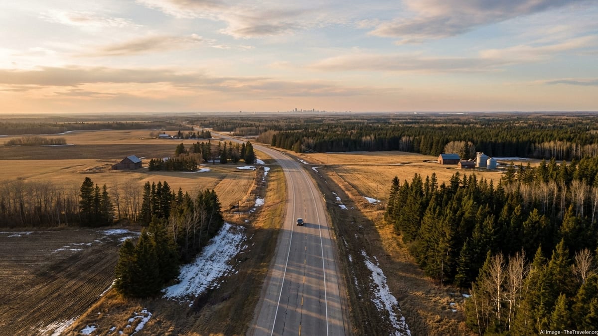
Driving is the most flexible way to explore Manitoba, especially in the populated south. The province’s section of the Trans-Canada Highway, officially Provincial Trunk Highway 1, runs for roughly 490 kilometers between the Saskatchewan and Ontario borders, passing Brandon, Portage la Prairie, and Winnipeg. It is a divided highway for almost its entire length and forms the main east–west spine for both commercial and leisure traffic across southern Manitoba.
North–south travel relies heavily on routes such as Provincial Trunk Highway 6, which runs about 740 kilometers from near Winnipeg to the city limits of Thompson and is the principal all-weather road link to northern Manitoba. Expect long stretches between towns, limited fuel stations in some segments, and frequent encounters with heavy trucks. Conditions can change quickly, particularly in winter, so monitoring road advisories and weather forecasts before departure is essential.
Driving regulations will be familiar to most North American visitors. You drive on the right, speed limits are posted in kilometres per hour, and seatbelts are mandatory for all occupants. Around cities and towns, limits are usually about 50 km/h, while rural highways range roughly from 90 to 110 km/h. Manitoba allows right turns on red lights after a full stop unless otherwise signed. There are no toll roads, so you will not encounter additional highway fees en route to your destination.
Road conditions are generally good, but winter is a defining factor. From roughly October to April, snow, ice, and blowing wind can create blizzards, black ice, and zero-visibility conditions. Winter or all-weather tires are strongly recommended in the cold season, and it is wise to pack an emergency kit including warm clothing, blankets, food, water, and a shovel. In more remote areas, always travel with a full tank and let someone know your route and expected arrival time.
Car Rental, Urban Driving, and Public Transit
Most visitors arrive by air at Winnipeg James Armstrong Richardson International Airport, where national and regional rental car companies maintain large fleets. A valid driver’s licence from your home country is typically acceptable for short visits, although an International Driving Permit is often recommended if your licence is not in English or French. Rental contracts usually include basic liability coverage, but you should confirm details with your provider or personal insurer before driving.
Leaving the airport by car is straightforward. Winnipeg’s Perimeter Highway encircles the city and connects to the Trans-Canada Highway and other major routes, allowing quick access to Brandon in the west, the Ontario border in the east, and northern highways leading toward communities such as Gimli, Ashern, and Thompson. Signage is clear and in English, and traffic volumes are moderate compared with larger Canadian cities.
Within Winnipeg, driving is relatively simple, with a grid-like street layout punctuated by a few major arteries and bridges over the Red and Assiniboine rivers. Parking is widely available but can be regulated or time-limited in the downtown core and around popular venues. If you prefer not to drive in the city, Winnipeg Transit operates an extensive bus network that serves major attractions, suburban neighborhoods, and the airport. Buses are low-floor, with ramps for mobility devices and strollers, and run from early morning into late evening on most routes.
For travelers combining public transit and intercity trips, the city functions as a natural hub. You can use local buses or taxis and rideshare services in Winnipeg to reach bus depots, rail stations, and the airport, then switch to long-distance modes. This hybrid approach is particularly effective if you prefer not to manage a rental car in winter but still want to explore beyond the downtown area.
Regional Flights and Northern Air Travel
Given Manitoba’s size and the limited all-weather road network in the north, regional flights are central to moving people, goods, and medical services between communities. Winnipeg’s international airport serves as the primary hub, with scheduled flights connecting to larger centers such as Brandon, Thompson, and The Pas, as well as to smaller northern communities and remote settlements that lack permanent road access.
The province maintains a network of northern airports, many of them gravel or compacted-surface airstrips, which provide year-round access for passenger, cargo, and medevac flights. For travelers heading to destinations like Churchill, known for polar bears and northern lights, flying is often the fastest and most practical option, especially in winter. Seasonal tourism flights and packages typically bundle airfare, local transportation, and guided excursions.
Regional carriers operate smaller aircraft, so baggage allowances and boarding procedures may be more restrictive than on large national airlines. Weather delays are common in northern Manitoba, particularly in autumn and winter when snow, low cloud, and high winds can reduce visibility or make runways difficult to maintain. It is prudent to build buffer time into itineraries and avoid tight connections when moving between regional flights and long-haul services.
Prices and schedules fluctuate by season, with higher demand during peak tourism periods and school holidays. Advance booking is recommended for travel to popular destinations, as aircraft seats and hotel rooms in small communities can sell out quickly. For essential travel to remote communities, local advice is invaluable; community offices or tourism operators can provide up-to-date guidance on flight options and typical seasonal patterns.
Winter Roads, Remote Communities, and Seasonal Access
Beyond the paved highways and all-weather roads, Manitoba relies on a unique network of seasonal winter roads to link many remote northern communities with the provincial highway system. Built over frozen lakes, rivers, muskeg, and packed snow on land, these routes typically operate only during the coldest part of the year, when ice thickness and ground frost are sufficient to support heavy vehicles.
The winter road season is short and highly sensitive to temperature and snowfall. Provincial authorities publish information on opening and closing periods, but exact dates vary each year. Travel is not approved on closed sections, and roads can deteriorate rapidly with mild weather, especially when temperatures rise above freezing or water begins to pool on the ice surface. Freight operators are encouraged to move supplies as soon as sections open, because sudden warm spells can shorten the usable season.
For residents of isolated communities, winter roads are crucial for bulk deliveries of fuel, building materials, and groceries and for temporary personal travel by vehicle to neighboring towns. For visitors, these roads are not a casual adventure drive. Conditions can be extremely slippery, visibility can drop to near zero in blowing snow, and assistance is limited or may be hours away. The province strongly recommends careful preparation, reduced speeds, and generous spacing between heavy vehicles traveling on ice stretches.
Anyone considering winter road travel should be well equipped and experienced in severe-winter driving. Essential items include proper cold-weather clothing, survival gear, high-quality winter tires, and communication devices suitable for remote areas, such as satellite phones. Before setting out, travelers should check the latest winter road reports and weather forecasts, and inform someone at their destination of their planned route and expected arrival time.
Intercity Buses, Trains, and Other Ground Options
Intercity ground transportation in Manitoba has changed significantly over the past decade, with the withdrawal of some national bus services and the emergence of smaller regional operators. Routes tend to concentrate along major corridors linking Winnipeg with Brandon, northern centers such as Thompson, and certain communities in neighboring provinces. Schedules and operators may change, so it is important to confirm current timetables and booking procedures before planning around a specific bus route.
Where bus options exist, they can be a cost-effective alternative to renting a car, particularly in winter when highway driving requires extra caution. Many long-distance buses are equipped with onboard washrooms and luggage holds, and provincial regulations increasingly emphasize passenger safety, including adequate heating systems during cold-weather operations. Even so, travelers should dress warmly and carry snacks and water, as weather or road conditions can delay services.
Rail travel remains a distinctive way to reach certain Manitoba destinations. The national passenger operator provides long-distance services across Canada that pass through Winnipeg, linking it with cities to the east and west. Additionally, a separate route connects Winnipeg with Churchill on Hudson Bay, and for some communities along this line, the train offers one of the only dependable year-round transport links. Travel times can be long compared with flying, but the journey offers exposure to remote landscapes and can be part of the experience rather than just a transfer.
Within small towns and rural areas, local transportation options vary widely. Some communities offer limited taxi or shuttle services, while others may have informal rideshare networks or designated drivers. In many cases, especially in the north, visitors rely on prearranged transfers through lodges, tour operators, or community organizations. When booking accommodation outside major centers, ask specifically how guests usually get around and whether transfers from airports or train stations are included.
Driving and Flying Safely in Manitoba’s Climate
Weather is the single most important factor affecting movement in Manitoba. Winters are long and cold, with temperatures that can plunge far below freezing and wind chills that make even short outdoor exposures hazardous. Blizzards and blowing snow can close highways and halt flights, while extreme cold can strain vehicle batteries, fuel systems, and aircraft operations. In contrast, summers are generally warm and pleasant but can bring thunderstorms, heavy rain, and occasional flooding in some regions.
Before any road journey, especially outside major urban areas, it is wise to check current highway conditions and short-term forecasts for both your route and destination. In winter, visibility may suddenly deteriorate due to blowing snow even if the temperature is clear and sunny at your starting point. Drivers should be prepared to turn back or wait out a storm if authorities advise against travel. Carrying a charged mobile phone, a physical map, and a stocked emergency kit will make it easier to cope with unexpected delays.
Air travelers face similar weather-related considerations. In northern Manitoba, crosswinds, low cloud ceilings, and heavy snowfall can force flight cancellations or diversions, especially at smaller airports with limited equipment. Pilots and airlines place safety first, so delays are common during severe weather, and there may be fewer options for rebooking than in larger markets. When planning tight itineraries that involve both regional and international flights, allow extra connection time, and avoid scheduling must-attend events immediately after planned arrivals.
Season-appropriate clothing is non-negotiable. Even when moving mostly between vehicles and heated buildings, travelers should pack insulated outerwear, gloves, hats, and sturdy footwear for winter trips. In summer, insect repellent and sun protection are essential, particularly in forested or lakeside regions where mosquitoes and blackflies can be intense at dusk. Good preparation will not only keep you safe but also make it more enjoyable to get out of the car or plane and actually experience the province.
Planning Your Manitoba Itinerary by Region and Mode
Because Manitoba’s transport options vary so much by region, it helps to organize your trip around hubs and realistic travel times. In the south, most visitors use Winnipeg as a starting point, then add side trips to Brandon, Riding Mountain National Park, or the lake communities along Lake Winnipeg. A rental car works well for this network, with paved highways, frequent fuel points, and short to moderate driving days.
For central and northern Manitoba, combining flights and ground transport is usually more efficient. You might fly from Winnipeg to Thompson or The Pas, then connect to nearby communities by road or local transfer. If your ultimate goal is Churchill, you can either fly from Winnipeg or travel via a combination of road and rail, using Thompson or other northern centers as staging points. Each combination comes with different costs, travel times, and weather sensitivities, so it is worth comparing options in light of your priorities.
Travelers interested in Indigenous culture, northern wildlife, or backcountry experiences often coordinate closely with local tour operators and community organizations. These partners can advise on the most reliable way to reach their locations, whether by charter flight, scheduled regional service, or seasonal road. They can also help you understand local expectations around advance booking, baggage limits, and cultural or environmental protocols once you arrive.
Wherever you go, flexibility will serve you well. Building spare days into your schedule, avoiding overnight drives, and planning alternate routes or backup activities can transform potential disruptions into manageable inconveniences. In a province where nature exerts such a strong influence on transportation, travelers who respect those forces typically have the richest and safest experiences.
The Takeaway
Getting around Manitoba is less about mastering a complex transit system and more about respecting distance, climate, and local realities. In the south, a reliable highway network and an international airport make it straightforward to combine driving, flights, and city transit. Farther north, regional aviation, winter roads, and rail lines knit together small communities across vast stretches of forest, rock, and tundra.
With thoughtful planning, appropriate gear, and realistic expectations, these logistical challenges become part of the adventure rather than obstacles. Whether you are cruising along the Trans-Canada Highway, watching the landscape change from prairie to boreal forest, or boarding a small aircraft bound for a remote bay on Hudson Bay, the journey itself offers insight into how Manitobans live with their environment.
By understanding your options for driving, flying, and regional travel, you can design an itinerary that suits both your comfort level and your curiosity. The reward is access to a province that feels wild and open, yet threaded together by the practical, resilient systems that keep people and goods moving in all seasons.
FAQ
Q1. Do I need a car to explore Manitoba?
While you can experience Winnipeg using public transit, taxis, and rideshares, a car is the most flexible way to explore smaller towns, parks, and rural areas, especially in southern Manitoba.
Q2. What are typical driving times between major Manitoba cities?
Approximate times vary, but allow around two hours between Winnipeg and Brandon and significantly longer for northern centers such as Thompson, where journeys can take most of a day by road.
Q3. How dangerous is winter driving in Manitoba?
Winter driving can be challenging due to snow, ice, and low visibility. With winter tires, cautious speeds, and close attention to weather and road reports, most trips are manageable but require respect for conditions.
Q4. Are there toll roads in Manitoba?
No. Manitoba’s highways, including the Trans-Canada section through the province and major routes around Winnipeg, do not charge tolls for regular vehicles.
Q5. Can visitors use winter roads to reach remote communities?
Winter roads mainly support local residents and freight. Experienced drivers sometimes use them, but they are not designed as tourist routes and require serious preparation and attention to official advisories.
Q6. What should I know about flying to northern Manitoba?
Regional flights often use smaller aircraft and are sensitive to weather, so delays are possible. Book early in peak seasons, check baggage rules, and build extra time into connections.
Q7. Is there train service to Churchill and northern Manitoba?
Yes. Passenger rail links Winnipeg with northern communities along a line that continues to Churchill on Hudson Bay, offering an alternative to flying for some travelers.
Q8. How reliable are intercity buses in Manitoba?
Where routes exist, buses are generally dependable but can be affected by weather and road conditions. Schedules and operators may change, so always verify current information before traveling.
Q9. Do I need special insurance to drive a rental car in Manitoba?
Rental vehicles usually include basic coverage, but you may wish to add optional protection or rely on coverage from your credit card or personal auto policy; confirm specifics before you drive.
Q10. What is the best time of year to travel around Manitoba?
Late spring to early autumn offers the easiest road conditions and the widest range of outdoor activities. Winter is rewarding for northern lights and polar bear trips but demands more preparation.